Double decker buses are now a common sight on the Harbour Bridge since Auckland Transport started using them for the Northern Express in 2013. If mayoral candidate John Tamihere gets his way it won’t just be the buses that would be double decked but the bridge too. On Friday he released a plan to replace the existing bridge slide a new double decked structure on to the existing piers.
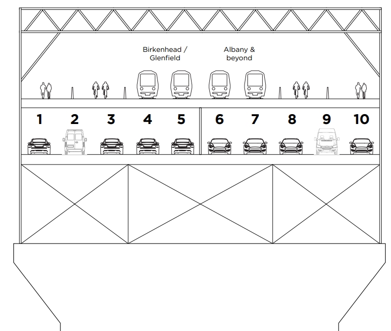
“A new 10 vehicle lane Harbour crossing, which will carry cars, rail, pedestrians and cyclists can be completed within 6 years on the existing bridge piers, replacing the existing bridge,” Tamihere said.
“There will be minimal disruption to traffic
He gives more detail about the idea in a separate document, including this
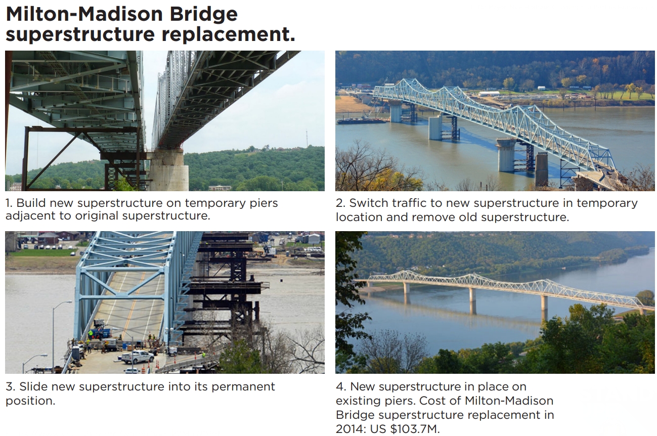
The superstructure replacement process is:
- Build new AHB superstructure on temporary piers to the east ofthe existing bridge;
- Switch road traffic to the new superstructure;
- Remove the old superstructures from the existing piers;
- Slide the new superstructure west, over 24 hours, to its final positionon the existing piers;
- Allow traffic to flow on the 2 footpaths, 2 cycleways, 10 road lanesand 4 rail tracks on the new superstructure in its permanent position.
Full or partial superstructure replacement has been carried out on a number of bridges in the United States including the Milton-Madison Bridge over the Ohio River which was built in 1929. Its superstructure was replaced in 2014 at a cost of USD $103.7m.
Below are some thoughts about the idea.
Is it practical?
As Tamihere has said, this was done on the Milton-Madison Bridge over the Ohio River. However a quick look at Wikipedia suggests this is a significantly difference scale. The Milton-Madison bridge is a two-lane bridge that was replaced with wider two lane bridge (and footpath) and it only carries about 10,000 vehicles as day. By comparison our Harbour Bridge carries about 171,000 vehicles per day but even more people due to around 50,000 people crossing on buses.
It also says they had to close the bridge to all traffic for 15 days while they slid the new superstructure in to place. That’s a lot more than the 24 hours Tamihere claims and would be some serious disruption even if it took place over the quieter Christmas/New Year period.
It’s not a local project
It’s all very well to propose the Harbour Bridge be replaced but this isn’t something the mayor has control over as the bridge is owned and operated by the NZTA. Tamihere claims this isn’t a problem, saying: “Who cares? They do as they’re told. They’re bureaucrats“, however, even if that were true, they’re accountable to the government.
Of course, as Mayor he could advocate for the government to support the idea but who knows how long that could take.
It doesn’t really add any road capacity
The plan is for 10 road lanes, and while that’s more than the eight we have now, the movable barrier means that we already operate the bridge with 5 lanes in the peak direction anyway. This means ultimately, you end up with the same issue the NZTA have with their road crossing proposals. You either add more capacity and make congestion worse as well as undermine goals to improve the city centre or you spend a heap of money to add no real new road capacity, in which case, what’s the point.
It’s also worth remembering that earlier this year the NZTA confirmed the best option for a new crossing was one that was light rail only.
It seems the only real benefit from this proposal is the addition of the PT and active modes but then why not just deal with those on a new dedicated crossing instead of trying to shoehorn them onto the existing bridge with all the compromises that would entail.
How does it connect
Perhaps the biggest issue with the proposal is the question of how it all connects.
- A 10-lane bridge is wider than what we have now, and so the bridge would have even greater impacts have on Northcote Point and St Mary’s Bay? As we’ve seen in the past with Skypath and past widening of the motorway through St Mary’s Bay, those residents aren’t afraid to make their voices heard.
- Adding a second deck to the bridge is one thing but at either end those people and trains up the top somehow need to be able to get on and off the bridge. Once it’s off the bridge, where does the rail line run, and how does it connect to the city and the rest of North Shore? The cost to do those connections, let alone the amount of space that might be needed could be substantially more than a new purpose-built bridge (or tunnel) on a better alignment.For those mode obsessed people out there claiming all new rail lines should be heavy rail connected directly to our existing lines, it’s also worth noting that the existing bridge is too steep and so this would have to be some form of light rail.
- The connection issue also applies to pedestrians and cyclists who would also have to somehow get up above those traffic lanes. This is likely to make it even harder for those with limited mobility.
It’s not all bad
For all its issues, it is probably less crazy than the NZTAs plans for another crossing which their own analysis shows will only make congestion worse. One thing I particularly like about the proposal is the inclusion of four tracks allowing for rail connections to both the busway and perhaps up the western North Shore. This is something we’ve suggested in the past too as it gives a greater opportunity to address future capacity needs and is something that’s much easier to future-proof for with a bridge than a tunnel. There’s also a huge amount of space for cyclists and pedestrians.
I also think it’s good that we have a discussion about the merits of a cheaper bridge for any future (PT + active only) crossing as opposed to a tunnel.
Be more creative
Even if this idea was feasible and affordable, if we were to go to the all the trouble to replace the bridge structure, why would we replace it with something that looks the same as is and not with something less ugly.
Goff’s Response
For his part Mayor Phil Goff is rubbishing the idea saying:
The 18 lane harbour bridge that John Tamihere is proposing would cost over $10 billion to build.
— Phil Goff (@phil_goff) August 16, 2019
It feels like Goff just pulled the number out of thin air given I can’t recall seeing a suggestion like this before in any of the many NZTA studies over the years. The idea is silly enough on it’s own that it doesn’t need made up numbers to make it look worse.
Penlink
The final part of Tamihere’s announcement was that he would commit to building Penlink. Noting:
The 7km Penlink road, consented to run between the Northern motorway and the heart of the Whangaparaoa Peninsula, will reduce traffic flow by an estimated 50,000 vehicles per day through the Silverdale Business area.
Almost 130,000 vehicles a day travel through the heavily congested business area.
A few quick comments on this
- Penlink is already committed to and is listed as a decade 1 project as part of ATAP. The biggest thing that prevents it from happening sooner is the cost, now estimated at around $400 million.
- The text above is almost word for word from a Chamber of Commerce press release. It was wrong then and is wrong now. For example:
- The business case expects just 16,800 vehicles a day to use Penlink in 2046. That’s not close to the 50k claimed.
- Auckland transport’s Traffic count numbers, suggest that fewer than 50k vehicles use the Hibiscus Coast Highway road through the business area daily, even at the motorway end. This is backed up by …
- The NZTAs motorway data shows 38k vehicles use the ramps at Silverdale with most (about 32k) using the south facing ones.

 Processing...
How do the trains make the climb? Stop while the driver gets out and presses a button to summon an elevator?
I think Tamihere must be proposing a funicular, well at least he’ll not have to worry about musical royalties for the upcoming adverts: https://m.youtube.com/watch?v=yTSAZAHiOa8
If you check out this longer version there is a tram at 3.54min which will be all that could be afforded after it’s paid for , and another scene with people receiving walking sticks to cross over it
https://www.youtube.com/watch?v=ybJJ5AIQ_k0
Up and down 5% incline ramps.
Two questions:
1) Even if you did want a new bridge, why wouldn’t you leave the old one alone and build another to supplement it? Or at least build a new bridge alongside and demolish the first if you really couldn’t handle the colossal mindfuck of a city with two bridges across a body of water.
2) Why do politicians feel qualified to do transport engineering? They don’t make the same claims about sewer mains, water reticulation or upgrades to the national power grid. Driving a car doesn’t make you any more qualified to plan bridges than using a toaster makes you qualified to plan power substations.
Yes why bother? The Milton-Madison Bridge was a very specific example & must of had good reason for it.
There was good reason for what was done at Milton-Madison and the problem they faced there is not uncommon. We are facing it in Auckland.
Strikes me that ALL politicians believe they are transport engineering experts. One of the most important reasons for NOT putting AT under direct Council control. Remember how pork-barrel transport decision making was prior to 2010. Important we don’t forget that with all the chatter about “greater acccountability” – which is code for putting it under political control. AT is already under Council control – the ultimate sanction is for AC not to fund projects that are not politically acceptable. We don’t need politicians debating how wide a cycle lane should be or where bus routes should go.
The Waitemata Harbour crossing is, however, important enough a crossing that politicians are inevitably involved in decision making about it.
1) Even if you did want a new bridge, why wouldn’t you leave the old one alone and build another to supplement it? An entirely new bridge would cost at the very least $4 billion, and likely a lot more than that. The superstructure of a new bridge would cost in the order of $2 billion, as in the above costing, but the cost of building the substructure and approaches would be many billions.
Or at least build a new bridge alongside and demolish the first: Building a new bridge alongside the existing presents most of the costs and difficulties as building a new bridge on a new route.
2) The person who decided that the United States should land a man on the moon and return him safely to earth by the end of the 1960s was not a rocket scientist. It was a political decision and the decision was made by a politician after getting advice from the rocket scientists. Whether to spend billions of dollars of public money on a public project is very often a decision for politicians to make.
The rail and pedestrian bits are simply a political focus grouped sop to appeal to as wider cross section of voters as you can, in JT’s road to electoral nirvana. Pure unadulterated cynical politics with all the genuineness of a 2 dollar shop Rolex.
However back on planet earth we have seen that NZTA cannot even get it’s shit together to add a footpath to the bridge so this epic fantasy would be so far behind their collective squabbling bureaucratic ability to make the second coming of our dear lord Jesus Christ a far more likely scenario!
The sequence of thinking behind a proposal that contains so much provision for PT and active transport was not driven by cynicism. The sequence was: more capacity is needed through the bridge alignment for PT and active transport. The clip-ons should, if at all possible, be retired from active duty or replaced, asap. Replacing the superstructure is feasible, affordable, would involve minimal change to communities or land use, other than during construction, and would allow for 10 secure lanes for the foreseeable future. If the superstructure is replaced it would not at all difficult or expensive to include a second deck below the existing deck level for vehicle lanes. The upper deck can be up to 35 metres wide, would not carry vehicular traffic, so there would be all the room ever needed for PT and active transport.
NZTA’s plan is to add a fourth structure to the original piers. Rather than have a house will three ill fitting, incongruent additions, it is a viable option to remove the original structure and the two additions and build one new structure than can do all that is needed of it, but has the same appearance as the original house before the two additions. The Mayor of Auckland is empowered by legislation to advocate policies he or she believe in, get voted in on those policies, and then implement them if they can get the Governing Body’s support. That gives the Mayor the opportunity to cut through any disagreements between bureaucrats, and implement the policies the Mayor was elected on.
Will, are you aware the harbour bridge is a government owned asset and not a council asset?
Yes of course.
Tamihere Mc Cleary from Mike Hosking’s Dairy… This is some cutting edge stuff. It would be great if the bureaucrats who will be delivering this for him could actually provide a basic overview of how impractical this would be. Although we are not talking about building a wall. It has got a similar populist whiff to it; which will unfortunately be lapped up by talk back land. Bonkers.
I wait for John Tamihere to declare Mexico is going to pay for his bridge.
Or that there is going to be an off ramp to Mexico.
If a mayoral candidate can offer an offramp to Mexico (the country), I am in…mmm tacos
The experts, including some who have actually designed and implemented similar projects, advise that it is practical.
Sure it’s technically possible but only at astronomical cost, including long shutdown periods where the bridge wouldn’t be available to traffic at all. Plus no mayor has the authority to tell NZTA what to do with its assets.
What will the bridge replacement cost?
The Milton-Madison bridge replacement project replaced a 6.0 metre wide, 1,000 metre long bridge deck with a 13.5 metre wide bridge deck. The cost was $103.7m in 2014; approx. NZ$ 200 million in 2019 dollars which is approximately NZ$14,000 per square metre (sqm) of bridge deck. The AHB replacement will create 70,000 sqm of deck @ $14,000 per sqm amounts to a total of $980 million. To that we have added 50%, $500 million, to allow for increases in costs over the time of the build and increased costs for the project being in New Zealand; total $1.5 billion. We have also added a 33% contingency, a further $500 million, bringing the total cost to not more than $2 billion. This is a conservative costing. Bridges are usually costed in New Zealand at around $5,000 per sqm of deck including the cost of foundations and piers.
I’d be worried about the “build the new bridge on temporary supports” part. Temporary supports capable of taking the weight of a new bridge are going to have be pretty damn strong – as strong as those existing permanent supports. I don’t know how they got away with it in Ohio, but those steel supports sort of bolted onto the side just don’t cut the mustard with me. If you’re going to be building a bridge, then build it on a decent proper foundation, in which case: why bother to then slide it off that and back onto the old foundations. It’s all pretty dumb thinking.
But plus, of course, we all know that the bridge is not the issue. As has been shown here at GA many times, the restriction is at the CMJ, not the bridge. So: marks of D or E for Tamihere all round as a practical suggestion, although an A for an idea to stir up the general populace who will have as much / as little clue about the feasibility as he does. The idea is half-baked, but it will get votes regardless.
Yes that example is quite a small bridge width to start with (1 lane each way), they obviously wanted to keep the original alignment or why bother?
It was only 6 m wide, but 1,000 metres long with a similar numbers of piers and span lengths as the AHB. They looked at dozens of alignments for a new bridge but, as in Auckland, there was always good reasons for ruling out every new route they came up with. Same thing happened with the Huey P. Long Bridge in New Orleans. Auckland is in the same position. The least expensive, quickest, and least disruptive option is to rebuild what is already there, where it already is, to provide the maximum connectivity through the existing alignment, indefinitely.
There would be some saving on the supports since they won’t need to have an indefinite life but any saving there would be eaten by the cost of the move and all the unnecessary demolition works. I doubt it’s any cheaper than building a new bridge (if not more expensive).
The only reason I can think of to justify doing this is if building an alternative solution was prohibitively expensive. Thankfully for Auckland a new PT + Active bridge would be substantially cheaper than this chimera.
As it happens building permanent bridge foundations in deep water is enormously expensive, but building temporary foundations connected to permanent ones, as can been seen from the Milton-Madison example, is relatively inexpensive. The appearance of the Milton-Madison temporary piers does not inspire confidence in their suitability for the job, though of course they were obviously fit for purpose, and did the job they were designed to do extremely well. The diagrams in the Q&A from a Milton-Madison powerpoint are very reassuring. The temporary piers for the AHB would be equally fit for purpose, but would be designed to inspire the confidence that their effectiveness deserves.
Milton Madison is not equivalent at all to the Harbour Bridge. It’s a piddly little 2 lane bridge.
The clip-ons need a solution in the 2020s, as does new PT and active transport. A solution to address all these criteria, other than the bridge replacement, would likely cost at least 3 times the replacement, and take decades.
The clip ons are fine.
After several reinforcement projects, the clip-ons have decades of life left in them.
Hi Snozzle and Logaramithic Bear. The clip-ons do have a couple of decades left in them, but may have loading restrictions from 2030. As it is 2019 now it is surely time to look at replacement.
[Post deleted by admins as blatant electioneering]
I am more interested in knowing if Tamihere didn’t know the harbour bridge isn’t part of the Council job or if he knew but figured that was a good thing because most people wouldn’t know and it meant he wouldn’t have to build it.
Either way a vote for John Tamihere is a vote for a misogynist.
On the wider issue here – Tamihere is cynically presenting himself as the “rebel” candidate with (nonsensical) “out of the box” thinking that “shakes the tree” of his imaginary establishment conspiracy when in reality he is a Manchurian candidate for the usual hodgepodge of chancers, liars and grifters funded by then usual frustrated plutocrats who used dity politics to get rid of Len Brown and now have themselves a useful idiot to try and get rid of Goff, all in the furthering of a certain agenda tro asset strip the council where they hope they’ll be in line to clip the ticket for fat, fat fees paid for generations of public money.
it is really unfortunate that Trumpist populism is being irresponsibly seized upon by serial losers like Matt McCarten and John Tamihere as their latest lazy attempt to find a way to power.
He’s essentially presenting himself as the candidate of change when he’s actually rallying against change to a more multi-modal transport system:
“Goff is waging war on cars now while promising public transport improvements five years away. He’s backing AT in their anti-car agenda – check out my webpage for proof that there is a planned assault on motorists,”
He will get traction from the pro car campaign of that there can be little doubt. You only have to look at the shambles created for vehicles exiting and entering the greater CBD thanks to the near closure of Quay St. The Strand and all roads feeding it are terrible at and around peak.
I don’t like him or his politics but the constant attacks on the main form of transport in Auckland need to be far better strategised than they are at the moment simply because the alternatives are either non existent or lagging well behind
“…but the constant attacks on the main form of transport in Auckland need to be far better strategized”
Care to elaborate? By and large the SOV continues to be the main priority for AT.
I think that with multiple rail and cycling lanes, this proposal is a huge step forward for multi-modal transport, something that has been conspicuously missing outside of central Auckland. Tamihere seems to understand what Goff does not, which is that all of Auckland is waiting for public transport infrastructure, not just areas with Labour/Green MPs. He could win a lot of support.
There’s a lot of US-style rhetoric coming into this local election. It’s not healthy to see words thrown around on here like misogynist, unhinged, Trumpist, and serial losers when we are in this awful climate emergency. This bridge idea is just one proposed solution and on the face of it is much better than what is currently (not) planned.
With the potential PT upside on offer, this is an idea worth considering if it is at all feasible, and we should probably do proper analysis rather than throwing stones and pointing fingers.
I’ll defend miffy’s use of the word misogynist, because Tamihere is not fit to represent the women and children of this city as mayor. I have been in contact with Christine Fletcher questioning why she has given her support to him, because in doing so she has let down the decent people in my electorate who expect NZers to make progress on the issue of rape and how society deals with it.
David B – Tamihere isn’t planning on building this bridge, he’s just hoping to fool enough people into voting him in where he can blame NZTA for blocking it.
Once in he can get started with selling the port and working on getting traffic lights phased so that car travel is slightly better than it is now and pedestrians have to wait 10 mins to cross.
[Post deleted by admins as blatant electioneering]
re David Bs comment: Well put. The bridge replacement proposal is the only option that is feasible, affordable and can be built in the 2020s. There absolutely needs to be a solution delivered in the 2020s. The current NZTA / Auckland Council plan is to build a tunnel in the 2040s, possibly.
The mayor we need’s a mayor indeed, a mayor with weed is better; a mayor with breasts and all the rest, a mayor who’s dressed in leather.
The Mayor we need’s a Mayor indeed, A Mayor who’ll tease is better
Our thoughts compressed, which makes us blessed, And makes for stormy weather… 😉
I was listening to Placebo. I thought I was listening to something else but it turns out I was in the control group.
excellent…. tres droll…
Part of the Mayor of Auckland’s job to ensure that the partners in the $28 billion Auckland Transport Alignment Project, central government and its agencies and Auckland Council and its CCOs do the jobs that they are each supposed to do. The Mayor of Auckland has as much say in ATAP as anyone.
Given that the mayor can’t even compel AT to do anything, what makes you think they’ll have better luck with NZTA?
The Mayor of Auckland, whoever it is, can’t just tell AT, the NZTA and central government what to do, but they can successfully influence those parties with a mandate from the Auckland public. The legislation provides for it and Len Brown, for example, certainly influenced central government of the time to start funding the Central Rail Link well before they wanted to, which appeared to be never.
Tamihere is not campaigning in a vacuum. There will be “business interests” providing him with finance, and ideas. Obviously the money is better then the ideas. I think the ideas can be best summarised as, any thing opposing any Labour Greens proposals and policies and their candidates. Bit like Hoskins but even more unhinged but the backers are probably largely the same.
I’d like to know who would back such a plan, though. Not Infrastructure NZ:
“But Infrastructure New Zealand CEO Stephen Selwood doubts it’s possible, with major logistical questions hanging over the plan… Selwood says it’s not just the bridge Tamihere will need to pay for – other connections have to be taken into account. “We all know that Spaghetti Junction on the southern side has not got much capacity in it, if any. You’d have to widen the Northern Motorway as well. And where does the light rail corridor go?” ”
Which is kind of telling, don’t you think? They love big expensive infrastructure projects, and were in support of the East West Link at the BOI hearing, even though they accepted it would be one of the most expensive roads in the world per m: “that works out at $327 million per kilometre, exactly the same price as a road which found considerable amusement to much of the world’s media as the most expensive.”
The EW link road will be revisited soon. Just after Penlink starts construction in a few months. Necessary to create the works pipeline. It has been realised the proposed light rail schemes are too future distant to be in the forseeable pipeline.
aka road construction company welfare.
[Post deleted by admins as blatant electioneering]
That was Mr Selwood’s response to the initial media reports which were misleading to say the least. Many in the media somehow managed to imagine that the proposal was to “replace the existing Auckland Harbour Bridge with an 18-lane super structure.” Not replace the superstructure of the bridge, but replace the bridge with a structure that is “super”, a “super sized” “mega-bridge”, a behemoth 2 or 3 times larger than what is there now. What was and is proposed is a replica of the original, but with the same width as the current bridge and with a second deck below the original deck level amongst the supporting steel work, so not obvious to the casual observer. Having now read and discussed the whole policy, if asked for his views by the media, mr Selwood’s response would be different.
[Post deleted by admins as blatant electioneering]
Hi Heidi. Please ask Stephen Selwood again, or suggest to Stuff that they do.
Willy. A double decker bridge is just yet another incredibly expensive proposed construction looking for a problem to solve. There are two sets of existing pinch points that determine the existing cross harbour capacity and neither of these sets of pinch points are above the Waitemata Harbour. These pinch points are around the junctions with SH1 on both the north and south side of the bridge. Increasing vehicle capacity at these points will be massively expensive, financially and environmentally and will at best provide only short term relief as the pinch points just relocate further up the road.
However very substantially increasing people carrying capacity along the route is very achievable at relatively modest comparable cost by increasing the capacity of the existing busway by upgrading multiple connected vehicles, trams infact, and bypassing the existing bridge by a dedicated two lane/track public transport only corridor, tunnel or bridge, for these vehicles to access the CBD. Electrifying this mass transit system would provide significant ongoing emission reductions.
The busway has already shown that carrying people in larger vehicles is the way to go, by being a lot more efficient and cost effective then providing more general traffic lanes.
Advocating for better mass transit would display real leadership towards improving transit, and our responsibilities to our city and to our planet. The last person we need here is yet another populist reactionary, when our world, and more importantly our future world, is already being endangered by too many irresponsible populist politicians, Trump, Johnson, Morrison and Bolsonaro and others. The massive costs of a refusal to institute policies and investment decisions to reverse our increasing climate changing emissions, will be borne by all of our descendants.
Hi Don. Don’t shoot the messenger. The deteriorating clip-ons and the lack of PT and active transport on the AHB are problems looking for a solution. The proposal is to have a 10 lane AHB to match the 10 lanes to the north and south of the bridge. No works on the motorways would be required.
Many candidates have advocated for improved electrified rapid transit. I invite you to read the transport policies of all the candidates and parties contesting the Auckland election.
Lack of PT? That would be the lack of a busway that carries almost half of all people crossing the bridge at peak times?
Yes lack of active modes, which is what Skypath addresses.
Will, it really is great to get more and more candidates proposing for electrified mass transport on high use corridors including across the harbour. And obviously advocating for a pedestrian and cycling crossing as well. So really great and I can assure you I will be examining each candidates proposals before casting my vote, and I really do encourage everybody to do this and most importantly to actually vote.
Totally agree with you Don. Electric traction; supplying the power to move, to a moving vehicle, while the vehicle is moving, is so miraculous that it makes all other forms of non-active transport, including Tesla, look like the Flintstones. Electric traction, made functional by the most under-rated genius of the 19th and 20th centuries Frank Julian Sprague, most conveniently requires steel rails and an overhead live wire. Fortunately, Auckland has many kilometres of just that and it can be extended.
So Will, just to satisfy my own limitations in analysing complex situations I think we both agree that provision is required for the following across the harbour at, or very near the current bridge crossing point;
A double track electrified passenger rail, weight irrelevant.
A high capacity pedestrian and cycle route.
A sufficient number of traffic lanes to maintain the traffic flow to at least the capacity of the existing limiting traffic choke points to the north and south of the bridge.
My observation is that the existing number of lanes acheives this. Currently traffic flow is regulated not by capacity across the bridge but at the junctions approaching the bridge, in spite of there being more available lanes at those points. I would surmise that it is a form of turbulent flow induced by the traffic merging and separating manouevres that junctions entail thus by reducing the capacity at junctions, in this case by the of one lane in ten. Even with the existing complex divided lane availability across the bridge.
Granted though, a permanent 5 lane in each direction would improve the counter peak direction speeds.
So I see it, broken down to the simplest I can manage is, we could either; build the walkway/cycleway as a further addition to the existing pylons and provide a totally separate bridge, or simple double track bored electrified rail tunnel from the Wynyard reclamation, bypassing the space constrained St Mary’s Bay foreshore. I use the term simple, compared to a road tunnel on account of the reduced ventilation and fire suppression required.
I know some parties are promoting the idea that the clip ons are severly time limited but this view is not the current NZTA position, and there does not seem to be any serious engineering expert argument that debunks that view.
Or we could have the Tamihere bridge, which does give an advantage extra lane in the counterflow direction.
But It seems like an extraordinarily complex, disruptive and shockingly expensive option to gain one extra lane.
More electioneering rather the engineering.
[Post deleted by admins as blatant electioneering]
Just a hair-brained idea that is impractical, has little gain, and would be incredibly expensive.
But in elections you can promise anything to get votes.
Structural and bridge engineers say that the replacement proposal is practical. The proposal has tremendous benefits and at $2b from at $28 billion budget is affordable and excellent value for money.
The landing in Northcote Point also looks a bit complicated. There is a substantial stretch of bridge before you reach the truss.
Yes, there is a bit to do on Northcote Point. However it is all very doable, and the result would be a new, compact, high capacity road, rail and active transport corridor that would improve the amenity of Northcote / Stokes Point for residents. The real opportunity is to get the road, rail and active transport traffic through Northcote Point and then down to the huge area around where the toll booths were, and where the elephant house and storage area of various road building equipment is now. With five lanes permanently each way, the area could be completely rationalized and tidied up and rail to Akaranga Station and Seapath built.
While I generally agree with everything Matt wrote, this part “the movable barrier means that we already operate the bridge with 5 lanes in the peak direction anyway” isn’t quite on the money as driving from the North Shore over the bridge late afternoon / evening is usually an absolute nightmare with just 3 lanes heading south.
Optimising the flow with the moveable barriers does mean the counterpeak flow becomes congested. Google traffic shows you’re right:
Typical Monday afternoon at 4:30:
https://i.imgur.com/WXxVvzx.png
Typical Monday morning at 9:10:
https://i.imgur.com/59FOuJr.png
We’ve been sizing roads for the peak flows, and inducing peak traffic in the process. The question then becomes do we add two lanes in order to retain both the peak flow we have and to ensure there’s spare extra capacity for the off peak flows – which will induce more traffic off peak too?
The counter-peak lanes do tend to carry more vehicles per lane than the peak direction lanes. Some details on numbers from a few years ago here
https://www.greaterauckland.org.nz/2015/05/19/breaking-down-harbour-bridge-volumes/
Having five lanes permanently each way may induce a small amount of off peak traffic, but inducing counter-peak traffic to a level that would be of concern is almost certainly not going to happen. What would happen is that it would allow reliable off peak travel, and produce some helpful rebalancing of traffic volumes as the Waterview Tunnel has done.
Please provide evidence. How does an increase in off-peak vehicle travel provide the necessary increase in access for people who don’t drive? It doesn’t, it will undermine the provision of better off-peak public transport services.
Tamihere hasn’t identified the problems that need to be solved.
All the road building projects act to induce traffic. We’re spending money trying to shift the dial the other way, with modeshift away from driving. Any road building project is thus wasting the money on not just its own project but on the projects that are mitigating that induced traffic effect.
Auckland agrees. Heading south over the bridge with 3 lanes is always at least unpleasant, and is often a nightmare.
Not really. Most Aucklanders don’t use the bridge and would see spending huge amounts of money on it as a waste.
That’s not the peak direction
Tamihere says: ” Full or partial superstructure replacement has been carried out on a number of bridges in the United States… The Huey P. Long Bridge in New Orleans is another example.”
Wikipedia says of that bridge https://en.wikipedia.org/wiki/Huey_P._Long_Bridge_(Jefferson_Parish)
“As originally constructed, each roadway deck was 18 feet (5.5 m) wide, with two nine-foot lanes; but because of the railroad component, it is unusually flat. Normally, bridges its height have a hump, but this bridge was designed flat to facilitate rail traffic.”
And here’s what google shows. Hmmm… imagine this scaled up to 4 rail lines, and much higher because our bridge does have a hump:
https://www.google.co.nz/maps/@29.9519428,-90.177237,3a,75y,174.12h,75.11t/data=!3m7!1e1!3m5!1s73DbBBa5d7U1_PzhJEyivQ!2e0!6s%2F%2Fgeo3.ggpht.com%2Fcbk%3Fpanoid%3D73DbBBa5d7U1_PzhJEyivQ%26output%3Dthumbnail%26cb_client%3Dmaps_sv.tactile.gps%26thumb%3D2%26w%3D203%26h%3D100%26yaw%3D237.81972%26pitch%3D0%26thumbfov%3D100!7i16384!8i8192?hl=en
As in the policy document, the replacement bridge would have exactly the same shape and appearance as the existing bridge. As tram-trains will be used, which can go up and down the 5% grades of the AHB, the enormous ramps needed to get 1% incline railroads up and over the Mississippi would not be required. I have been driven over the Huey P. Long and have met with the engineers who designed the renovation project; the renovation of that bridge and the people who did it are extraordinary in every way.
I think he’s basically proposing this as a spoiler for future development. If he gets in then he’ll point to any PT only crossing and say his idea was better so that’s that we’re going with. It will then be found to be infeasible resulting in a delay to a PT crossing at best or cancellation at worst when he doubles down on it. He wants to cancel investment in the city in favour of lowering rates but isn’t prepared to just come out and say that because it could alienate enough of the electorate to prevent his campaign from being viable. At this point I consider him to be campaigning in bad faith.
” campaigning in bad faith.”
Is that any surprise?
He’s a politician like all others
The bridge replacement was determined to be feasible by a number qualified people around 5 years ago and none of them have changed their opinion since so it would be foolish to bet on the project being shown to be infeasible. The replacement is not part of some Machiavellian plot to achieve some hidden purpose. The proposal is what it appears to be and is presented in good faith.
Was expecting this post today. Wow he’s really trying for a big ticket item to win. Ridiculous.
There doesn’t appear to be any mayoral candidate that I can support. I wish Brown would come back.
I agree and at least the right person will get his name on the plague on completion of the CRL not these other idiots that had no input in it to start with
On the plague? That sounds unpleasant.
Sorry that should have read plaque but you must admit most of the mayors are a plague
If he wants to do this, it would be much more simpler to build the new bridge alongside and then demolish the old one. Similar to what they did with the Newmarket viaduct.
Might well cost a whole heap of money though but a new bridge would be so much better to look at than the coathanger monstrosity that is there now.
That method would not be any simpler, but would be at least $2 billion more expensive and would present significant resource consent challenges.
An significant point about the AHB is that it looked dramatically better as built in 1959, the clip-ons disfigures the original bridge. Please google Auckland Harbour Bridge 1950s and see how it looked in its glory days.
I’m not sure anyone can take Tamihere seriously after this crazy idea. A pity as I am not a fan of Goff either, but at least his “promises” are a bit more realistic. Not that they mean anything as noone in local or central government are held accountable. Interesting that Goff is trying to separate himself from his paymaster in Labour by his campaigning being all blue.
Yeah, I noticed that too. Quite symbolic.
Goff won’t fool anyone with his coat of blue paint. Like any elected politician, he must be judged by his actions, not his words. And his actions say that he is a Labour mayor, not an Auckland mayor.
Goff has always been a bit wet – never too excitable. Nice enough fellow and all, but nothing that is going to frighten the cat, which is probably what you want when you are running the city. He’s not bonking on the table in the boardroom, or driving his Rolls Royce around with his nose in the air. Hubbard (remember him) was way too wet for wards, while Banks was…. just a weird choice for a Mayor once, let alone twice.
Tamihere is more down the entertainment route, shocking people by saying words like front bum (easily shocked people – no big deal really), and in this instance, howling loudly at the sky. It gets attention, which is what he wants – attention gets him free publicity.
The proposal is perfectly sane, sensible, realistic, reasonable and feasible. The media did confuse themselves as to what the proposal is and have tried, erroneously, to characterise it as pie in the sky. It isn’t.
I don’t think it’s a good idea.
In any case it could be improved by swapping top and bottom decks which would have the following advantages:
-rain cover for pedestrians and cyclists
-the overhead gantry frames would not be required for rail power as the wires could be supported from the deck above
-a moveable barrier could be used on the vehicle lanes as central columns not required on the top deck
– Covered public areas are problematic. The views from the top level would be utterly spectacular for pedestrians, cyclists and rail passengers and would be wasted on car drivers who should be concentrating on the road.
– Ground level power supply will be used from Esmond Road to Spark Arena.
– The bridge will be permanently 5 lanes each way to match the 5 lanes each way leading up to either end of the bridge so there won’t be a movable barrier.
The real issue the “supercity” of Auckland has is that cars are still seen as the optimum intracity form of transport. In a time when climate change is becoming less and less deniable (although plenty still do), to be considering maintaining or increasing private traffic capacity is a sin. Trains, light rail, bikes and buses need to be the priority for any true leader of this city. Certainly not selling off assets to pay for climate destroying megaprojects. Tamihere in charge would be very scary indeed, at least Goff is relatively harmless.
Yes well said Matthew. Auckland needs a mayor that will provide leadership for our times – a person who is prepared to say, amongst other things, our environment demands that we need to drive less. Then they need to talk about mechanisms to achieve this.
“The last IPCC report stated that global emissions of carbon dioxide need to be halved by 2030, and eliminated by 2050 if global warming was to be halted.”
It’s also not going to happen just by having free bus rides on the weekend on electric buses, whenever that might happen.
On the topic of emissions, I heard that Tamihere responded to a question about climate change (at a meeting in Howick) that Auckland needed to increase speed limits and that we’re spending too much on bike lanes. Any there to hear this, and confirm he really is this misinformed?
[Post deleted by admins as blatant electioneering]
On Q & A last night mayor Phil Goff also stated that 53% of arrivals in the CBD via the Auckland harbor bridge each work day are bus passengers in his attempt to devalue the need for a replacement bridge.
I interpret this to mean that 47% wish to travel beyond the CBD and to do so must use their car or van. This number will continue to increase and the extra lanes will cater for them.
They will not want to spill out onto existing off ramps, another of Goff’s fears, if they are like me they will not want to see the CBD at all. A mix of tunnels and fly-overs will be needed to get these motorists off Tamahere’s bridge and clear of the city.
Remember when the original bridge was built? I do. And I remember how traffic volumes were badly miscalculated to the extent that within a few short years the clip-ons were required. Are we going to repeat the same mistake again or are we going to think ahead and be brave and future-proof our next effort?
Yeah, building more roads and destroying inner City neighbourhoods is definitely forward thinking! We are all stuck in 2019 and you all the way out there is 2119! Roads..the future.
As in previous post, no changes to any motorway is envisioned as part of the bridge replacement project.
“the need for a replacement bridge.”
NZTA is already planning 2x tunnels under the harbour. Most probably for mass transit. Either dedicated bus tunnels or light rail
NZTA is planning tunnels but the construction of them is unfunded and is not expected to happen until mid-century. If future generations decide to build a tunnel or tunnels, having a fit for purpose AHB from 2025 won’t hinder any such plan in any way whatsoever. With a fit for purpose AHB in place in 2025 for $2 billion possibilities such as a rail tunnel between the eastern CBD and Devonport can be explored and the final plan brought forward to complement the fit for purpose AHB.
When building a road, bridge or tunnel, the number of lanes to be built has to be chosen. The recently completed Victoria Park Tunnel and the Waterview tunnel have 6 lanes. The new Newmarket Viaduct has 7 lanes. The advice is that 10 lanes is the right number for the replaced AHB. With five lanes each way 24/7, 2 footpaths, 2 cycle paths and 4 rail tracks, the proposal is future-proofed to provide for the reasonably foreseeable needs of future generations, as required by purpose clause of the RMA.
Something to consider regarding penlink that isn’t taken into consideration with the metrics you mentioned.
A significant amount of the population in Whangaparaoa, Gulf Harbour are retirees and people who generally stick to the area. This is changing as the cost of homes in the area is significantly cheaper than other north shore areas. More and more young families are making it their home and the growth is noticeable from a residents point of view.
Silverdale park and ride is overflowing, already! The ferry service in Gulf Harbour is at capacity for normal business hours and later sailings are getting more crowded. The parking facilities at the ferry are mirroring Silverdale park and ride. Just look at the mud banks and tire tracks.
As more long term residents (2 person sized families) move out they are being replaced by younger families with 3, 4 and 5 person compliments.
So let’s say, hypothetically, that Penlink is fast tracked and built over the next couple of years.
Home buyers who were put off by the 46km distance from Gulf Harbour to the city are now reconsidering the area with Penlink’s reduction to under 30km.
What happens next? More people decide to settle there, house prices increase, established residents capitalise on this, sell up and make way for bigger families, developers notice the growth and increase available accomodation. This all just reinforces itself.
Pretty soon you’ve reached 50k vehicles and if history is anything to go by, surpassed it.
There’s a reason Whangaparaoa locals are demanding Penlink, we know the potential is there.
Have you looked at alternative scenarios, Guy?
Even if Whangaparaoa people allow zoning to intensify, and they’ve shown no interest in doing so, their transport needs can be sustainably met with public transport improvements. Building Penlink would induce a lot of vehicle traffic throughout the whole city, and thus be a terrible outcome for climate change, for our safety crisis, and would keep our children in their current state, of having the lowest independent mobility they have ever had. This extra traffic will have knock on effects of unhealthy streets, low physical activity levels, high levels of traffic injuries and death, and poor social cohesion.
Penlink has a low BCR, and that low BCR appears much higher than it should, due to NZTA’s erroneous transport modelling and evaluation methods used.
If it is built, it will be for purely political reasons, based on misinformation and ignorance, and not for good planning, social or environmental reasons.
Instead of demanding Penlink, I’d like to demand that Whangaparaoa locals learn about induced traffic, healthy streets and the compact city strategy. Whangaparaoa will remain a much nicer place if they do.
Guy, Potential for what? Taxes, including rates are a scarce resource, which should be allocated wisely to acheive maximum benifit to our society as a whole.
I cannot see that a huge allocation of this communal resource, to increase the property values of a very limited area, and to give a quicker access to so very few, and an already relatively privileged group, to such an already highly committed transport corridor, the Northern Mototorway, as communal value. The induced vehicle load can only be to the detriment of the other existing users of that corridor. It is surely better, and a lot cheaper to concentrate on improving the lot of the 53% of the public transport commuters and therefore persuade even more patrons, across the bridge by this spacially efficient means. This can initially be a acheived relatively cheaply by more feeder bus services and providing better roadway priority for those services. The alternative is spending megabucks, and massive damage to inner city areas, by the provision of a mix of tunnels and flyovers just to improve the lot of the current 47% private transport users. A massive financial and environmental expense just to incentivise a declining minority to move away from an already provided public transport option at the expense of enhancing public transport. Madness, in my opinion but feel free to present alternative views.
[Post deleted by admins as blatant electioneering]
It’s not a local project: The $2 billion project would be funded from the $28 billion Auckland Transport Alignment Program, which is reset every year and in which the Mayor or Auckland has a much say in as anyone.
It doesn’t really add any road capacity: The proposal is not intended to raise road capacity, however it does raise counter peak capacity and, more importantly, counter peak reliability, which will help balance traffic on the network as the 3 lane each way Waterview tunnel has. Getting over the bridge on three lanes can take forever. On 5 lanes it will be reliable. The reasons for the replacement are: the need to retire the clip-ons which are not fit for purpose and will eventually need to be replaced or greatly restricted in use, creating 10 lanes to match the motorway configuration and to add the very necessary active transport modes and rail. The reasons for “shoehorning” them all into the existing alignment is that they all fit, and the connection can be done for a fraction of the cost and in a fraction of the time of trying to build new dedicated crossings.
How does it connect? The roadways through Northcote and St Mary’s Bay are already 35 metres wide, plenty wide enough for the needed 10 lanes; St Mary’s Bay already has 10 lanes. Attractive on and off ramps wouldbbe designed for rail, cycle paths and footpaths within the $2 billion budget. The old toll both area is a contender as the main junction point on the Northcote side, and there are a number of options on the St Mary’s Bay side. The eastern and western cycle and pedestrian ways will likely connect to eastern and western sides of the bridge at both ends of the bridge.
Adding a second deck to the bridge is one thing ….: The additional deck would not be 4.5 metres ABOVE the existing deck level, it would be 4.5 metres BELOW the current deck level. The PT and active transport would be at the level of the current deck, so at the same level that Skypath was proposed to be at. The on and off ramps are likely to be the same grade as the bridge, one in 20 / 5% which will present no problem for the tram-trains to ascend and descend.
Once it’s off the bridge, where does the rail line run, and how does it connect to the city and the rest of North Shore? On the city side the line would run on, as in the policy document, Westhaven Drive, Beaumont St, Quay Street then connect with the main line behind the old Auckland Railway Station. On the Shore, initially only one line would be built, as has already been planned, along the alignment of the southbound lane of the Northern Busway and on to the full busway alignment at the Akoranga Station.
The cost to do those connections, let alone the amount of space that might be needed could be substantially more than a new purpose-built bridge (or tunnel) on a better alignment: The land for the connections is available and the cost will be insignificant compared to the cost of a new harbor crossing.
For those mode obsessed people out there…: Fully laden existing Kiwirail freight trains won’t be rolling down Quay Street and climbing over the bridge. However if there is a desire to carry freight, the type of freight trains that operate on, for example, the Bernina Railway in Switzerland with 45m radius curves and 7% inclines, could operate over the bridge and on the North Shore. Yes, in Switzerland some of their trains do run in town and city streets, including freight trains. The “mode obsessed” have seen the John Tamihere transport policy and are pleased to see in it that all rail extensions in the plan will be built to Kiwirail track standards except in the stretches where that is impossible to do because of steep grades or sharp corners. Such stretches of track would take billions of dollars to bypass, but if they are bypassed at some stage in the future, all the other new track is ready to accommodate any Kiwirail train.
It’s not all bad: The provision for rail, pedestrians and cyclists is pleasingly generous as a consequence of the whole upper deck being available for it. The 2008 NZTA study and the rejected ANZAC bridge shows how difficult it is to propose a new bridge, let alone get it built. Making the most of the existing alignment, the existing approaches and the existing bridge design has very many advantages. The proposal is not in the least bit crazy. In fact it’s in the middle of the box, conventional engineering. The foundations of something are good for the foreseeable future; what’s on top of the foundations is not fit for purpose and a waste of the sound-as-can-be foundations and existing supporting infrastructure. Replace what’s on top. Standard stuff.
Be more creative: The replacement proposal is feasible and affordable. Beauty is in the eye of the beholder. There is a compelling need to make the bridge fit for purpose for the rest of the 21st century and beyond, but no need to change the appearance of what has graced the Waitemata Harbour for 60 years.
Goff’s Response: The Mayor believed Todd Niall’s report in Stuff that the bridge is proposed to have 18 lanes. The report was incorrect. The proposal is for a 10 lane bridge to match the number of motorway lanes to the north and south of the bridge. It’s not a silly idea and the only thing the made up numbers make look bad is the person who made them up. The Mayor did pull the $10 billion number out of thin air. The costing done with a method recommended by engineers is $2 billion. The detail of that costing is: The Milton-Madison bridge replacement replaced a single 6 metre wide, 1,000 metre long bridge deck with a 13.5 metre wide bridge deck. The cost was US$103.7m in 2014; approx. NZ$ 200 million in 2019 dollars which is approx. NZ$14,000 per square metre (sqm) of bridge deck. The AHB replacement will create 70,000 sqm of deck @ $14,000 per sqm amounts to a total of $980 million. To that we have added 50%, $500 million, to allow for increases in costs over the time of the build and increased costs for the project being in NZ; total $1.5 billion. We have also added a 33% contingency, a further $500 million, bringing the total cost to not more than $2 billion. This is a conservative costing. Bridges are usually costed in New Zealand at around $5,000 per sqm of deck including the cost of foundations and piers.
So why don’t you just build a new bridge alongside for the rail, walking and cycling? Even include a couple of new traffic lanes if you must.
Temporarily shifting the exiting bridge superstructure so you can keep it open while rebuilding a double deck on the old piers can’t possibly be easier, cheaper, or less disruptive than simply leaving it and building a new one alongside. What possible advantage is there in do that?
And sorry to be blunt, but you are naive to think this scheme would cost anything like $2b, or that it would be in any way easy to consent. You can’t sneak in a new double deck bridge with various approach ramps and roads just because it sits on the foundations of an old one. Have you considered that getting the consent for the temporary piers will be just as arduous as getting them for a permanent set? Seriously “$5,000 per sqm of deck including the cost of foundations and piers”?! You’d be lucky to apply the paving surface for that budget.
We realise that JT has no plans to actually build this thing and is just using it as a big idea to get headlines and bluster, but to claim it’s all been planned out by engineers and is perfectly viable is just dishonest.
+1
Hi Nick
Building a new bridge alongside the existing bridge means putting permanent foundations in the seabed down to bedrock. That triggers all sorts of significant resource consent issues.
You are quite right, the plan IS to simply leave the existing bridge where it is and build the new bridge alongside. However the difference to what is in your post is that the new bridge would be on temporary piers. The temporary pier struts are drilled through to rest on bedrock and attached laterally to the permanent piers. I don’t know how to post the engineering drawing of this, but they are impressively stable looking, as they should be.
The new bridge on the temporary piers would carry 10 lanes of traffic for probably two years while the old bridge is completely removed and the piers prepared for their new resident. Then the new bridge would be slid with high powered pulling jacks along girders into position on the piers that have been there since 1959.
The great advantage, and it is the killer advantage, is that because the bridge and the piers have been there since 1959 a new structure similar to the existing structure, on top of the existing piers, has existing use rights. The motorways either side are already in place so resource consents are not needed as the motorways would remain unchanged.
You CAN sneak a new bridge on to old piers. The second deck is below the original deck so the bridge envelope is no bigger and does not trigger major resource consent issues. If your house burns down, you CAN sneak up a new house within the same footprint and building envelope with minimal resource consent issues. You can even demolish a house down to the floor then rebuild a new house without significant resource consent issues, a friend of mine lives in a house that was built that way.
I work as a resource management lawyer and have consulted with leading resource management barristers about the resource consent issues that temporary piers and the proposed build would raise. There would be issues but building temporary piers has a much lower degree of resource management difficult precisely because the piers are only temporary. Any adverse effect is temporary, for the construction period, so getting resource consent is not difficult in the scheme of things.
Be as blunt as you like Nick. You are quite right; I am naïve, PR naive. I thought it would be straightforward to communicate this proposal to the media and the public and that it would be well received as a sound part of the suite of projects that Auckland needs to consider to accommodate growth. However the engineers I have consulted on this project, who design and build these projects, are not in the least bit naïve about the cost or the buildability of these kind of projects. When it comes to their work they are the most skeptical and risk averse group of people I have ever come across, which is understandable. Having a bridge that you have designed fall down during or after construction, or cost twice as much as you said it would, is a very bad look.
Nick, I kid you not. I have met with engineers who do this kind of thing all day every day. They say it can be done because they have done it. They can point to projects that they said could be done and then did them. They can show you what they estimated the bridge would cost and that the final cost was within their estimate.
The cost of building many things is difficult to predict. The cost of building major infrastructure is notoriously difficult to predict. From the Channel Tunnel to the CRL to Light Rail Projects in Sydney, the final cost so often bears only a faint resemblance to the original estimate. A factor that greatly increases unpredictability is any project that involves permanent structures underground. You can estimate all you like but until you actually dig the hole and get down there you don’t now what you will find.
Replacing the harbour bridge is very much at the lower end of the cost blowout risk scale. Whilst it is a big project, what is proposed to be built is temporary piers and a 1,000 metre long steel structure, 35 metres wide, and about the same number of metres high. Steel structures on this scale have been built since the 1890s. There is no mystery to them and little room for surprise. It would not surprise me if a large construction company gave a fixed price contract on the job because they would know down to nanometer what they would need to do, and what they would need to do it on top of.
Happy to catch up with you anytime to discuss at a venue of your choice and/or provide any material that interests you.
Will
021 899 502
Just a question on how they’d get the current motorway lanes from the old bridge to the temporary bridge Will.
I’m assuming that the temporary bridge would have to go on the eastern side of the harbour bridge given the western side runs straight off into litigationland (that being Northcote with the dozen or so holier than thou residents that have almost singlehandedly held up the skypath for the last 10? or so years).
But then you’ve got a problem at the St Mary’s bay end getting from the current lanes which take a right hand turn around the end of Westhaven onto the eastern side of the bridge.
Is the plan to bulldoze through Westhaven to connect the lanes to the temporary structure?
Or have NZTA, the same NZTA who are now consulting on whether to build stairs and lifts as an entry/exit to the skypath, come up with a better plan?
Which given how they seem to be struggling with a simple bike lane over the bridge seems nigh on impossible to this particular bystander…
All sounds quite convincing in a lot regards Will.
Question: Part of the 13m width includes the clip-on base bit doesn’t it? Would these be replaced with the new bridge idea, I’m guessing this component is not as robust as the the original piers?
To me the biggest problem is the extra general traffic lanes are not what we possibly want.
Aside from that, probably the cost unknown & delaying “Sky Bridge”, it would be better to have the rail as light rail to fit in with other current thinking rather than run heavy rail along Quay St. That is just nuts with what is currently been planned and desirable along the waterfront. I know other cities have odd bod HR running through towns etc but it’s not ideal.
Hi Grant
From what I have seen of the original plans and from what’s there, no. The original deck is 42’wide, around 13 metres, so its wider than that to the outside of the arches and the main piers are a little wider again. The clip-on’s go out substantially further than the original piers as can be seen from photos.
The clip-on brackets would likely be replaced as part of a spruce up of the piers and setting them up to receive the new structure. The new structure would not be any wider, but the clip-on brackets at least don’t look as convincing as you would want them to. The renovated Milton-Madison piers were about doubled in width but the job done in a way such that they look like they were built as they look now.
There are only two extra general traffic lanes, 10 in total, five each way. That doesn’t increase the number of traffic lanes operating at peak times. That would remain at five. Five lanes each way the whole way on undivided carriageways would be a significant improvement on what is there now.
Light Rail is a misleading term as so call “light rail” vehicles frequently weight the same or even more per metre of length as so called “heavy rail” passenger trains. No passenger rail is really heavy rail except in North America which has regulations requiring passenger trains to have a locomotive at the front, or weigh an extraordinary amount if self-propelled. Locomotives and fully laden freight trains are heavy rail.
Tram-trains going up and down Quay Street and the Harbour Bridge, as proposed, is almost exactly the same thing as “Light Rail” doing so, but tram-train is proposed so that services can be integrated with the regions existing rail network. Tram-trains, with ground power supply, would fit perfectly with the people focused Quay Street that has been started being built, but will take till right up to the America’s Cup in March 2021 to complete.
You will either need to widen the corridor along st Mary’s bay or reduce general lanes to accommodate any rail through there. The latter would defeat the purpose or matching lane counts with the bridge approaches. The former is not a good outcome compared to a new separate LRT alignment through or under Wynyard. A separate PT system with good connections gives us resilience rather than one fully connected system for the sake of it.
The plan is not to change the motorway through St Mary’s Bay which is ten lanes. The plan is for the initial pair of rail lines to run along Westhaven Drive, Beaumont Street and Jellicoe Street; through Wynwyard Quarter as you suggest Grant.
Someone with a connection to Greater Auckland has also made the proposition that separate incompatible PT networks provide resilience, whereas an integrated network does not. I have considered that proposition every which way and cannot see anything in it. One integrated network is inherently MORE resilient than numerous independent networks. It is not that case that in an integrated network one failure necessarily brings the whole network down. If there is a failure in one part of an integrated network the failure point can frequently be bypassed by rerouting precisely because the network is integrated, allowing the network to keep operating. That principle is one of the key things that allows the internet to work.
Hi Ma
Yes, the temporary location of the bridge would be on the eastern side. As you say that avoids disturbing the long established residential area to the west of the bridge. The image in the policy doc shows it reasonably well. Traffic heading north would come under the overpass to Ponsonby, around the big right hand bend but keep turning a little bit more, then straighten up to go join the bridge in its temporary position just between the Ponsonby Cruising Club and the existing bridge. The temporary on and off ramps would be made of temporary steelworks.
I suggest that some of the problems that NZTA is having with the Shared Path is that it will be the third clip-on and the fourth structure on the 1959 piers, which is a lot. It would be an extremely difficult job to carry out, and the cost of it could blow out due to the number of unknowns. I have read $100 m, but that could soon become $200 m. As someone else is saying that it is possible to replace the whole bridge for 20 times, possibly only 10 times as much as the Shared Path, it is understandable that NZTA doesn’t want to just promise the world with Rolls-Royce connections.
The thing that not has been said is were all this traffic will go when the Bridge is closed for the 15 plus days while the transfer is made ? , or will they have to go via riverhead or the upper harbour bridge ? . or will they dredge up the old ferries buried under westhaven mariner as at this moment in time there are around 4-5 vehicle carring ferries on Auckland harbour . and the passenger ferries would not have the capacity to handle all the commuters at the peak times . Even if it moved over the holiday period .
So basically all this is a pipe dream unless JT envokes the Waitangi treaty as part of the deal to get it built .
Hi David
The Milton-Madison Bridge replacement involved 15 days of closure over the whole process, not one closure of 15 days. If the Auckland Harbour Bridge is replaced it would involve one closure of 4 to 5 days from 27 December to set up the roadway from the current bridge to the new bridge on temporary piers. A second closure of 4 to 5 days would be required two years later to slide the new bridge into place on the existing piers and reset the approaches to their permanent location.
As you say, in that quiet period, people would use the Upper Harbour Bridge and ferries during those two closures. With a couple of years notice people would be able to suck up the inconvenience, as they did when the Newmarket Viaduct closed for a period during its replacement.
It’s not a pipe-dream. The Treaty of Waitangi would be respected, but would have little particular application.
People have been complaining about no rail services to the North Shore and the fact that you cannot walk across the bridge. There was a lot of excitement over the Skybrige proposal that was actually tacking on something to an old structure that has a limited lifespan and astronomical costs. Building another crossing would be at a huge cost. Engineers are the people who work out whether it is feasible or not and they seem to think it is so why are we saying it is not possible or won’t happen?
The real question is do we want it (the double decker bridge) to happen? I’m sure it is possible to build but it’s better to create a totally separate PT & active only mode bridge or tunnel. A few reasons:
1. This would mean less mode shifting back to cars which would only create more congestion in other parts of the city.
2. The recent fire near the bridge in the morning commute meant only 1 lane passing through blocking the buses as well. A separate structure joining reasonable “apart from it” would allow that part to continue as normal in that situation.
*reasonably apart from the other crossing pinch points.
Also see https://www.greaterauckland.org.nz/2019/09/03/58144/
Hi Jackie and Grant
The About page of this site says: “Greater Auckland was established in 2015 to provide commentary and encourage intelligent debate about transport and urban form issues, with a particular focus on Auckland. We want to make our city a better place for everyone.” I presumed from this that people post their own opinions and comments and that there is no Greater Auckland “we”. I certainly hope that there isn’t.
The Auckland Harbour Bridge bridge replacement proposal is not a manifestation of witchcraft that can be chased down with pitchforks and torches at hand and caught and burned at the stake by a “we”. The Auckland media has had a good try at doing that and haven’t succeeded.
It is an entirely feasible, buildable by 2025, affordable proposal that is on the table for consideration, now. The engineers not only think it is feasible, they know it is feasible. All the elements of the proposal have been proven time and time again over the last 200 years.
The Milton-Madison Bridge is a 1,000 metre long steel girder bridge with a deck 12.8 metres wide and a cantilevered 1.5 metre wide walkway on one side. It was slid 40 metres sideways in around 12 hours on to the piers of the previous bridge which had a 6.0 metre wide deck. The piers had been upgraded for their new tenant.
The original Auckland Harbour Bridge is 1,000 metres long with a deck 12.8 metres wide. The two clip-on’s and the original have a combined width of 35 metres which is wide enough for 10 lanes but the current bridges only carry 8 lanes. Building a 35 metre wide replica of the original on temporary piers to the east of the 3 existing bridges, switching traffic on to it, then later sliding the bridge into its final position is something that Auckland can choose not to do, or choose not to do.
The costing for the bridge, based on Milton-Madison, comes to $2 billion. That costing technique applied to the NZTA Shared Path proposal comes to $140 million. NZTA’s cost estimate for the Shared Path is $100m to $140m. $2 billion is entirely affordable from the $5.1 billion allocated to roads and greenfield infrastructure in ATAP, and the connecting rail can be built from the $8.4 billion in ATAP for rapid transit.
No one has to agree that the harbour bridge should be replaced, but it is an option. A separate tunnel for PT would be great, but that would not provide for active transport. A new bridge on a different alignment for PT and active transport only would also be great, but finding an agreed and consented alignment and design, and getting it paid for is at least mission incredibly difficult and almost certainly mission impossible until who knows when.
It would also be great to have a bridge next to every tunnel, a tunnel next to every bridge, and a spare road next to every road that carries traffic, all sitting there so that if there is an accident traffic can be moved onto the duplicate infrastructure. If someone wants to spend their own money to do that they can. If someone wants to spend other people’s money to do that, they can’t. Public money cannot be used to build redundant infrastructure when it could be used to build necessary infrastructure that would be used all day, every day.
The problem staring Auckland in the face is that NZTA estimates that by 2030 the clip-ons will have heavy vehicle restrictions re-imposed and the Northern Busway will be at full capacity. That situation will slowly strangle Auckland from around 2030.
There are two options on the table. The Auckland Council / NZTA proposal, in the 2018 ATAP document “Current investigation work into an additional Waitemata Harbour Crossing needs to be completed to provide more certainty about the optimal timing, modal mix, configuration and operation of the crossing. Consistent with earlier ATAP work construction is not anticipated to commence until at least the late 2030s.” I.e. the tunnel would not be operating until the mid 2040’s, possibly the late 2040’s.
The other option is to replace the deteriorating and inadequate bridge superstructures with one fit for purpose superstructure that would provide maximum connectivity through the existing corridor for the same period as the lifespan of the piers, indefinitely.
That the proposed replacement bridge has two decks is unremarkable. The replacement bridge would look almost exactly the same as the original bridge, and look better than the existing collection of bridges. The second deck would sit below the level of the current deck. An observer would hardly know it is there unless they knew what to look for. Bridges with two decks are as common as muck. Many of the bridges across the East River in New York have two decks. The now demolished 1933 Bay Bridge in San Francisco had two decks. Because, like the Auckland Harbour Bridge, most of the the Bay Bridge had steelwork above and / or below the decks, the Bay Bridge would have looked little different if it had only one deck.
The Newmarket Viaduct was replaced because it was inadequate, by a different method, but replaced nevertheless. The Auckland Harbour Bridge can also be replaced, if Auckland decides to replace it.
“$2 billion is entirely affordable from the $5.1 billion allocated to roads and greenfield infrastructure in ATAP”
So you want to slash the budget for transport in the growth areas practically in half to fund your pet project that the ATAP identified as not required?
By all means please outline what projects worth $2 billion from the Supporting Growth programme you are going to cut to fund this? Sounds like you’d need to cut supporting infrastructure for half of Auckland’s planned greenfield housing development to fund this.
What gets the chop? Have you consulted with the local boards of the north, nortwest and far south of Auckland that you are going to slash their growth budget? What about the MPs for these areas?
Likewise with the rapid transit, you’ll need to cancel about half the ATAP transit programme to fund your rail links. Which projects will you cut, northwest rapid transit, eastern busway, the CRL, maybe it’s the electrification to Pukekohe? Once again, please outline which projects you are cancelling to use that budget.
Its not a pet project, its a necessary project. Replacing the slowly deteriorating and inadequate Harbour Bridge has to take priority.
The rapid transit project to be cut to fund the $6 billion rail expansion would be the $6 billion Light Rail project.
Except that the Ministry of Transport, NZTA, Auckland Transport and Auckland Council wen’t through a multi-year process of evaluating all transport projects in Auckland, and concluded that it isn’t necessary.
…so let me get this straight, you are proposing to cut building two new train lines to the southwest and northwest, each over 20km long, which adds train stations to more than two dozen suburbs and serves the two main growth areas of the city… so you can build ramps to access train lines on a bridge we don’t need, just to replicate where we already have a busway? Not sure I agree with your priorities or you idea of value for money. Have you told the people of Mangere, Westgate et al that you are going to chop their train lines so that you can double up on the busway instead? Let me know how that sits.
Happy to agree to disagree on anything you like Nick.
NZTA says in its 3 September 2018 Ministerial Briefing Paper; “Auckland Transport’s North Shore Rapid Transit Programme Business Case (2017) …. concludes that a higher capacity PT mode will be required by the mid-2030s.” and “Forecasts indicate that restrictions for heavy vehicles on the AHB may be required by approximately 2030…. restricting heavy vehicle weights on the AHB (clip-ons) to less than 35 tonnes (is) one option.”
NZTA didn’t assessed replacing the harbour bridge as one of the 160 options considered in 2008.
AT predicts the Northern Busway is likely to warrant upgrading to rail by the mid-2030s and NZTA predicts that heavy vehicle restrictions are likely on the clip-ons from 2030. Replacing the Auckland Harbour Bridge by 2025 resolves both the need to upgrade the PT capacity of the Northern Busway corridor likely by the mid-2030s and the issue of the deteriorating clip-ons.
The proposal for 49 km of new rail for $6 billion includes the line through Mangere, so the people of Mangere would be well pleased. The people of the west already have the Western Line which provides good connectivity along that corridor, outstandingly so once the CRL opens. The Western Line does not go through Westgate and a second rail line to the west would be nice but building a first line to the north, southeast and east have obvious higher priority. A regular express bus from Westgate to the CBD utilizing motorway shoulder bus lanes where possible would be faster than travelling by car and would be an adequate interim measure.
Well yes precisely. NZTA have identified there is nothing wrong with the bridge, with the possibility for traffic management being required in two decades, or not.
And yes, a far more pressing need for rapid transit. So why are you proposing to waste all the money on the bridge, to the point of cancelling other rapid transit lines. Why not just build a rapid transit crossing and leave the bride alone?
It’s not really telling the full story saying the existing harbour bridge doesn’t need replacing, or another road crossing isn’t required. The recent work has intentionally be designed to make the need for a 2nd road crossing not needed due to the selected narrative of moving more people to the CBD.
When you take a step back and look at the entire city you will see that the harbour bridge has been at capacity for over 10 years now and the only reason it seems to work is because demand is held back and forced onto other modes.
If you choose to make a study about how best to get more people to the CBD another road crossing is just silly as we don’t want more cars in the CBD. But if you look at a study to improve transport in the region, then a harbour crossing like the one I designed over 10 years ago works a treat in terms of freeing up through movements without increasing demand for people to drive into the CBD.
Another deliberate move to prevent another road crossing making sense was the insistence that it was required to be made in conjunction with a PT crossing. This meant its geometry was contained to that of rail and therefore made it twice as expensive as it needed to be.
From what I’ve seen over the past 10 years or so, is that the recommendation of almost every DBC or IBC has been decided before the project even starts, and it terms into an exercise of selling what you’ve been told to sell while making some straw-man alternatives that are just plain bonkers.
Can you give a link to your design, Richard? I don’t know which one that is. How did it avoid the problems the one they recently showed made everything worse for everyone, including motorists?
Here is a really basic image of it.
If you don’t combine the rail tunnel with the road tunnel it can tie in at Onewa.
The design reduced the road cross section through St Marys bay to two lanes each way plus a busway/tram-line.
https://www.nzta.govt.nz/assets/projects/awhc/docs/2008-report/awhc-study-phase-2-map-preferred-option.pdf
Does that have the clip-ons taken off, or does it keep the same number of lanes on the existing bridge?
My plan back in those days was to keep the clip-ons for general traffic, run the tram/busway and trucks through the central span and then have a shared path added to either side of the bridge.
Doesn’t it just add heaps of capacity, then? Once the bridge fills back up with traffic, that’ll make Herne Bay, Ponsonby, Victoria Park unpleasant… and meanwhile the traffic from the tunnel will fill up spaghetti junction.
If you have a rail connection over the harbour plus a tram/busway on the bridge, you won’t need all those lanes of traffic. And would be far better off without that many. What am I missing?
The only capacity it adds is for PT and active modes. In terms of general traffic it has similar capacity to the current peak capacity. More importantly however it separates through traffic putting it out of sight and allowing to flow much better.
In terms of of the bay, it would have less than half the capacity and traffic as it wouldn’t be carrying through traffic. That allows you to narrow it down from 12 lanes to 4 lanes (plus the busway). That would allow you to greatly enhance the urban form around there, along with removing the flyover which would make the area much nicer.
In terms of a rail line, it would be rather nice as well. However it’s only focused on the CBD and would realistically cost something like $10 to $20 billion.
Does it use the Victoria Park tunnel for both directions, and remove the Victoria Park flyover? That’d be nice.
So how many traffic lanes in each direction would there be?
The design at the time built a 2nd Vic park tunnel that was needed as part of the construction staging but becomes a sound bound ramp to cook St. My thoughts at the time was to make it a bus only ramp, however if there was a desire to get cars away from Fanshaw St you could reverse this.
In total it was 10 lanes, so 5/5 rather than 3/5. This accounts for the fact there has been a very large off-peak flow.
The concern with 5/5 is that it increases peak counterflow, which there is a lot of. People do work on the NS, and they’re more likely to do the chauffeuring thing – drop spouses at work or kids at school – if only one direction is congested, etc. So there would definitely be traffic induced. Plus lots of person trips induced. When putting in public transport, there needs to be a reduction in the general traffic lanes.
If the clip-ons were a structural problem, you could take them off, and then your plan might be worth looking at, because the severance caused by the current connections to the bridge does need fixing. But it appears the clip-ons are good to remain, so it’s probably better to add the PT crossing separately.
If we already had the PT crossing in place, we could reallocate one of the clip-ons to walking and cycling, with a big sound proof barrier.
Well I think we will have to disagree on the “people in cars = bad” thing.
Whilst I can agree you can have too many vehicles, I don’t think intentionally creating as much congestion as possible to force people out of cars is very ideal.
“.. I don’t think intentionally creating as much congestion as possible to force people out of cars is very ideal.”
You could equally argue that people are been “forced” out of public transport & active modes by currently providing too much general traffic lanes all across Auckland. This includes the bridge & its approaches. Ever tried to walk cross Fanshawe St or cycle along Great South Rd for example?
ps my reply below is meant to be in this thread in reply to Heidi at 9:44 am above.
You’ve put words in my mouth, Richard. We can surely agree that fewer cars on the road, with more sustainable and healthy alternatives, is the goal?
There are ways to reduce congestion before reducing the number of general traffic lanes, such as reducing parking, but you don’t like that either. In practice, taking general traffic lanes and reallocating them to modes that are more space-efficient can happen in response to reduced traffic or as a way to reduce the traffic. Either way, it’s about a better, more sustainable transport network with improved choice, and ultimately, less congestion. All good.
Generally I agree with you, we need to give people the freedom to chose from a range of modes.
“Ever tried to walk cross Fanshawe St or cycle along Great South Rd for example?”
I’ve always found it super easy to cross Fanshawe St.
I agree GSR is bad, personally I completely disagree with the idea that cyclists can share a bus lane as it just doesn’t feel safe.
“such as reducing parking, but you don’t like that either.”
Actually I said I was all in favor at reducing parking at the destination.
In the CBD for example, improvements in PT and a reduced provision for parking is a highly effective way of improving mode share.
My issue with parking is removing the rules so developers can create entire suburbs with next to no parking resulting in people parking on footpaths and cycle lanes resulting in a reduced urban form and a much more dangerous road environment.
I think it wouldn’t need to as through route to south would join into motorway from a new tunnel I’m guessing. Is this a tunnel design Richard? It’s not stated I think.
Given the state of the AWHC and its costs (and the car-fixated view of the current govt) now, I wonder if the basic concept of replacing the bridge superstructure on the existing piers does have enough merit to be considered alongside whatever $10 billion boondoggle NACT wants, or Labour’s suite of $15-25 billion options fro m2023.
Of course I do not agree with the bridge being 10 general traffic lanes – most congestion at peak times seems to be entirely due to the lack of lane mathematics at onramps and merging points north and south of the bridge. Nor do i agree with sticking to the dated and austere coathanger design. And Mckenzie’s proposal really sounds like an advertising pitch – I should like to see some realistic-pessimistic costings, engineering assessments, and construction timeframes instead of this magical “$2 billion dollars, 24 hours to move the superstructure across” idea.
But if it stacks up cost, time, and risk wise, hey – why not?
Just build a second bridge and leave the first one alone.