“Let’s make every day in our city feel like a good party,” wrote Connor two and a bit years ago, after an excellent midwinter Matariki celebration on Karangahape Road. A big part of what made that event party involved closing a stretch of the street for a few hours, so people of all ages could fill the space and really relax.
This year, Halloween fell on a Saturday, and once again Karangahape Road was popping off, with a ton of activity along the street and around Beresford Square at the entrance to the new underground station.
Massive kudos to the Karangahape Business Association, who once again brought the vibes. A giant pigeon! A frog band! A dog costume competition! So much to love!
View this post on Instagram
The place was packed from late afternoon to the wee small hours. And yet, the street remained open to traffic. Which feels odd, because if not for this kind of event, then when?
The K Road Halloween party was like this for hours. They're going to need to close the strip to vehicles and open it to the people next time.
— Russell Brown (@publicaddress.bsky.social) 2026-10-31T23:16:58.797Z
The footpaths were so busy that the bike lane became a natural annex, making it more logical for those on wheels to take the street, amongst traffic and buses. Not necessarily ideal.
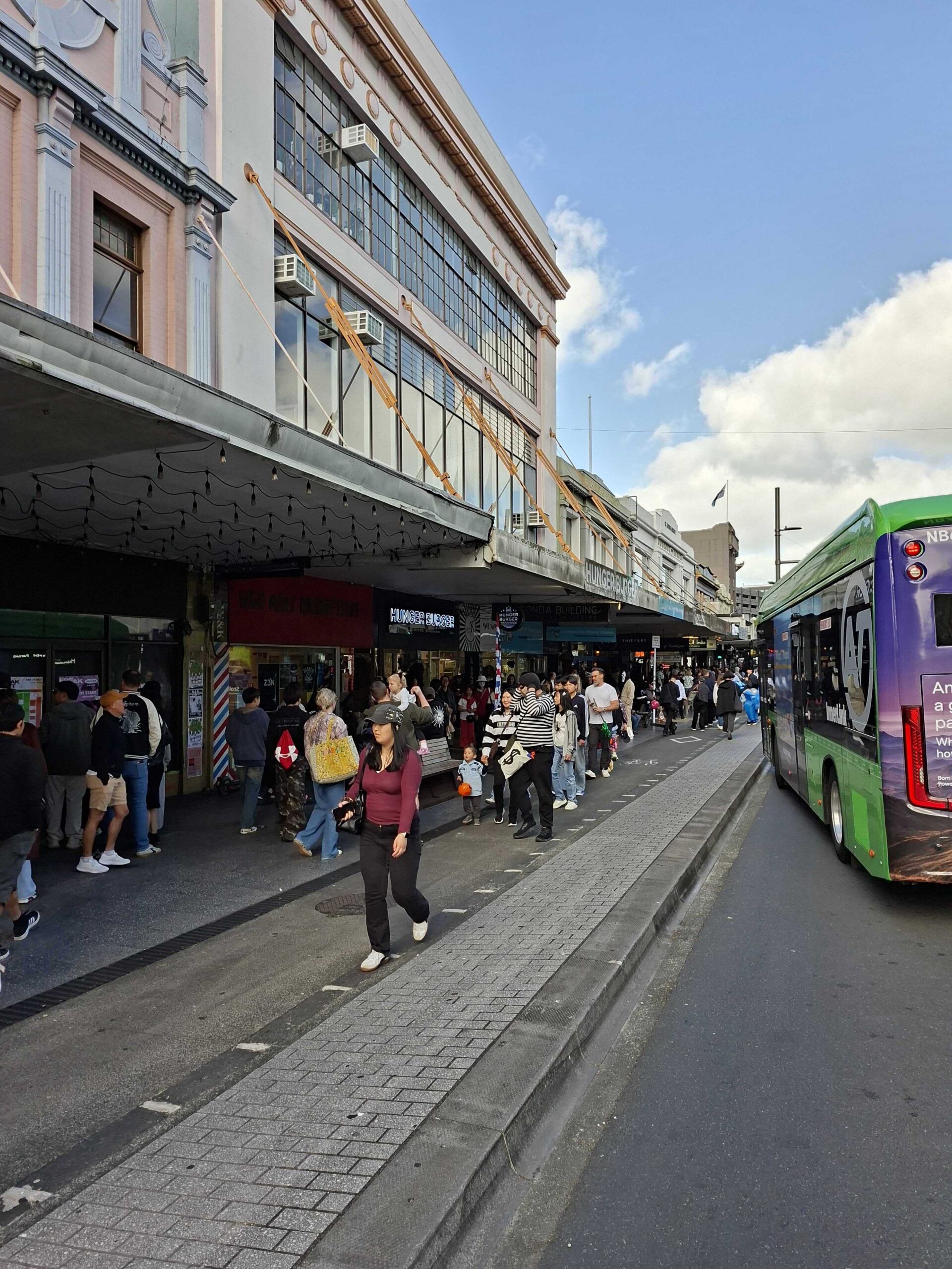
Logical, but not exactly ideal. Image supplied
Another thing we noticed on the night is how the new Beresford St public space both does and doesn’t work. It works, because like Te Komititanga, it’s now it’s a natural locus for events.
But the area out the front of the station entrance is not quite large enough for mass gatherings, with people trying to get through. And the area behind, between the station entrance structure and the ventilation building (where Saturday’s epic dog costume parade happened) can feel quite constrained.
View this post on Instagram
Another 10 or so metres added to either bit might have allowed for more of a public square feeling. On the other hand, nooks and crannies (and lanes and alleyways) – including the church over the road, plus Mercury Lane – allow for more spaces for lots of fun little things to happen. So, swings and roundabouts?
Thinking ahead for more events on Karangahape Road
Opening the stretch of Karangahape between Queen St and Pitt St for people feels like a more immediately solvable issue, and should by now be standard operating process for big social events.
This would mean re-routing the Red and Green Link buses – but that’s totally doable. The Inner Link (green) can be sent down Queen St, Mayoral Drive, and back up to Pitt St.
For the City Link (red), there’s a solution that comes with Patrick’s suggestion to extend the route to the Museum, as outlined in this previous post. The map below shows the City Link route, with potential event detour in red dashes – just add temporary stops at the top of Queen St, near Karangahape Rd.
So, whenever you wanted to close the key middle section of Karangahape Rd for events – which should be an easy and regular occurrence – you’d just keep the City Link on Queen St all the way to Karangahape, where it turns to head across Grafton Bridge and into the Domain, to stop at the Museum and turn around.
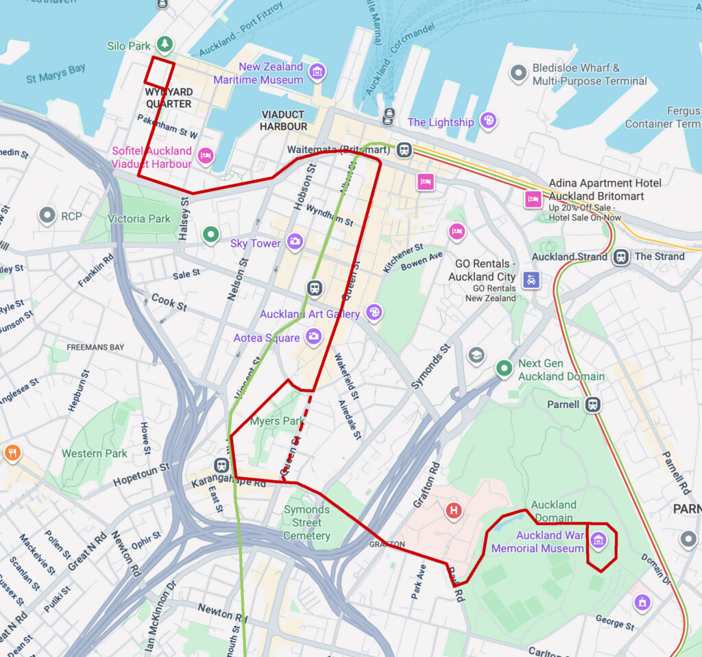
City Link extended to the Museum with alternative route for Karangahape Rd closures (dashed).
For Karangahape Road itself, the longterm vision – as per the City Centre Masterplan – is for the block between Pitt and Queen to become a transit mall. All circulation planning, and for bus routes in particular, should have an eye to effectively pedestrianising this stretch of road within the next decade.
In the meantime, considering we’re already looking at half a dozen event weekends a year – often on Friday and Saturday nights – you could look at the Amsterdam red-light district approach, where daytime access is available for motor vehicles, but bollards come up every evening at 7pm.
At the very least, it would be great to have a good “ready-to-go” street closure plan that could be activated as desired, or even on a regular basis.
Planning ahead for more streets for people
This isn’t just a question for Karangahape Road. Over the weekend, the new Te Waihorotiu station came into its own, bringing heaps of people directly to the Diwali festivities in and around Aotea Square. Notably, Queen St was closed between Wellesley St and Mayoral Drive on both days – so why not Halloween up the hill, too?
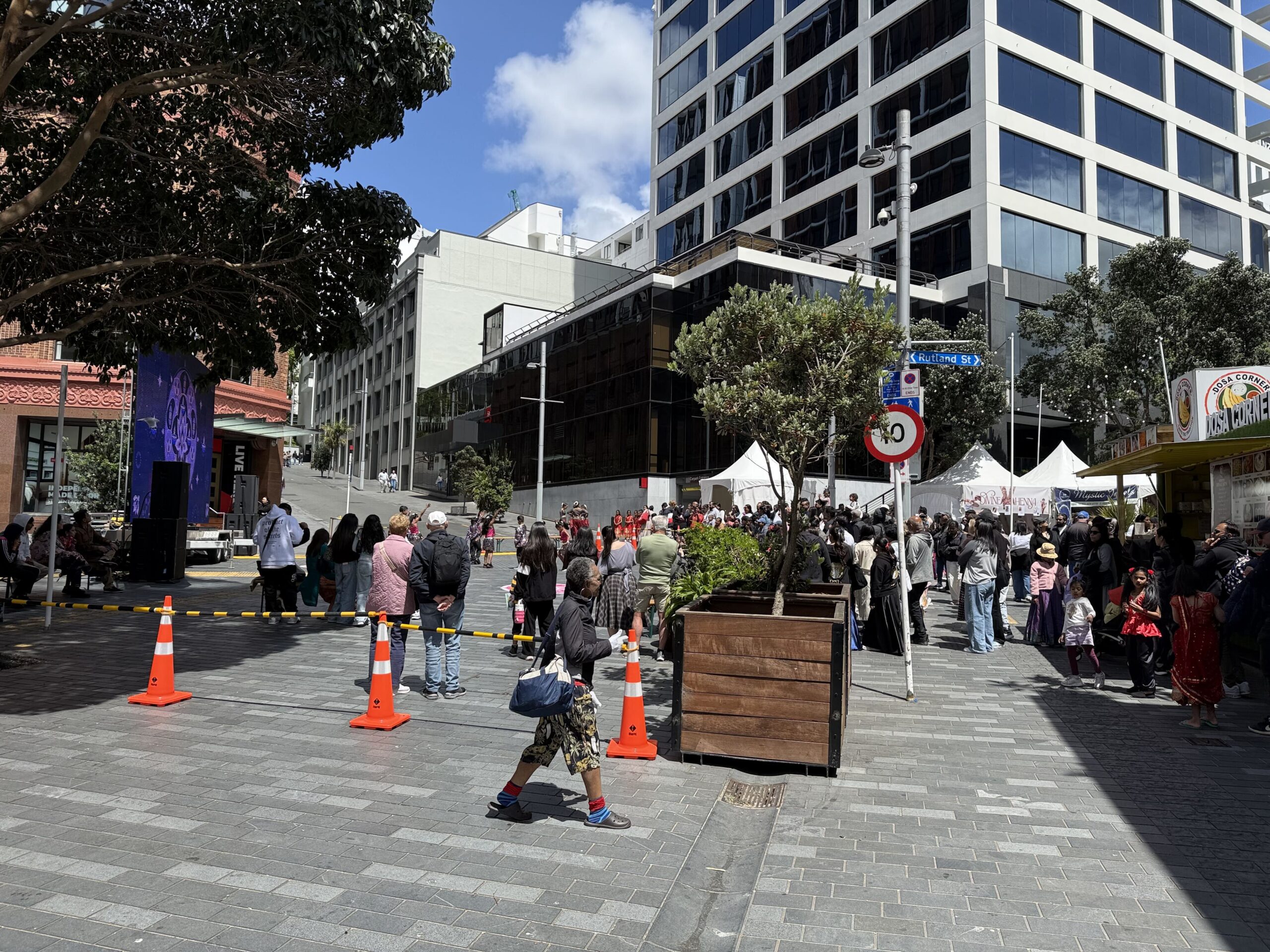
One neat addition to Diwali this year – extending it up into Rutland St. This helped free up room on Queen St, by spreading out the food vendors and space for people. Image supplied.
And every year, the same question hovers over local events – from Santa Parades (the big one in town, and the smaller but no less iconic ones in places like Te Atatū Peninsula), to New Year’s Eve, to Anniversary Weekend, and Waitangi Day, and more…
How can we give our main streets back to people, more easily and for longer, so we can all hang out and enjoy this great city?
A ‘play street’ is a fun thing in your neighbourhood
The question applies on a hyperlocal level, too. Saturday’s festivities also saw streets all over the city full of kids and families (and ghosts and dinosaursand princesses and vampires, etc) roaming around in pursuit of fun.
It goes to show that neighbours are keen to connect – as also shown by the evolution of Neighbours Day from one day, to a month-long celebration, to a year-round initiative, Neighbours Aotearoa.
So, with summer coming up, wouldn’t it be great to see more “Play Streets” in our city?
This winning concept is widely enjoyed overseas – see our earlier coverage of play streets in Berlin – and after a few years of local trials, Auckland Council has picked it up and run with it.
The local Play Streets programme lets residents designate a suitable street (quiet, low-traffic, non-bus-route) as a space where kids can play and neighbours can connect with each other. Who’s keen?
How does a play street work?
For 2–3 daylight hours, traffic on a suitable residential street is temporarily restricted so neighbourhoods can come together, play freely and safely close to home. Kids might ride bikes and scooters, draw chalk art across the asphalt, kick a ball around, build obstacle courses, or invent entirely new games on the spot. No programme, no special equipment – just simple, local fun.
A play street means residents and essential vehicles can still access the street, but at a slow, walking pace, guided by organisers. This approach creates a gentle shift that helps everyone see the streets as a shared space for people, not just cars.
Because play streets are designed for the people who live there, they’re intentionally small and community‑led. They’re not big public events, instead they’re about strengthening the bonds between neighbours and giving tamariki a safe, familiar place to play.
They work best on quiet streets or cul de sacs without heavy traffic, shops, or bus routes. Generally, places where neighbours are supportive and at least two households are keen to help lead this kaupapa.
For more info about Play Streets, and to register your interest, see here.
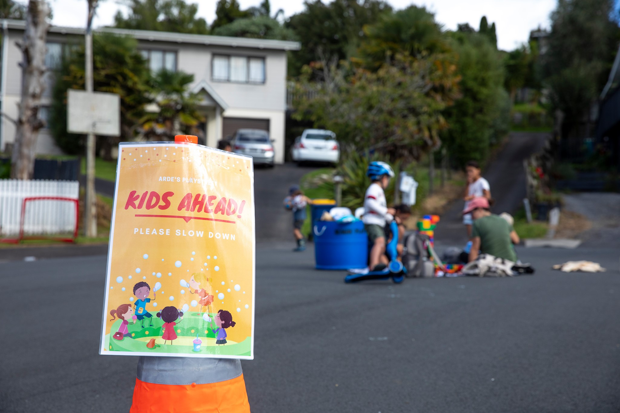
An Auckland Play Street event on a quiet cul de sac. Photo/ story: Chris Lange
How to lighten the load and free the streets everywhere?
The logical extension of this thinking is: what if a people-first street was simply our way of life? That’s the promise – and in some places, the reality – of low-traffic neighbourhoods, a topic we’ve frequently covered over the years. Here are a few posts on the topic:
Forming policy on low-traffic neighbourhoods, by Heidi, November 2020:
It is no surprise that low traffic neighbourhoods are gaining traction. The modeshift and traffic reduction gains are considerable, and quickly dispel myths that cycling and walking have only “fringe” benefits for decarbonisation. What mere “traffic calming” or “safety” project has Auckland implemented that comes close to returning mobility to people on bikes, especially women and children?
Urban playground: the child-friendly city, guest post by Alex Bonham, June 2021:
The iceblock test is a good indicator: could an eight-year-old go from their home to the dairy to buy an iceblock and get home before it melts? If so, then they are living in a child-friendly neighbourhood. For their parents this might also mean that the lovely café or bar with acoustic music is in walking distance too.
A low-traffic neighbourhood by any other name, by Jolisa, September 2021:
I think it’s okay to find some solace in our current quiet streets – a glimmer of active hope, even. They remind us there is a less stressful world for the taking, outside the front gate. The quiet streets of lockdown aren’t normal. But they could be.
You don’t have to time-travel, or fly to Europe, or wait for the holidays (or wish you could afford one), or buy your way into a fancy neighbourhood. We can start right where we are.

Taking the dog for a run, September 2021. Image: Jolisa Gracewood.
Auckland Transport protects children from mandarin hazard, A guest post by Chris Lange, September 2021
Local children were invited to share their ideas during the planning, then we set about implementing as many of their ideas as we could. Turns out they were event planning experts! By the time all the events were done we had done a wide variety of activities. This included lots of sports, a range of new toys, art, and fun with bikes.
Liveable arterials, by Heidi, November 2021
I believe we can recreate these streets so they become “liveable arterials”. I believe they can function much better for all the people that use them, whether they are on foot, in wheelchairs, moving freight, travelling by bus or bike or other small wheeled ‘micromobility’.
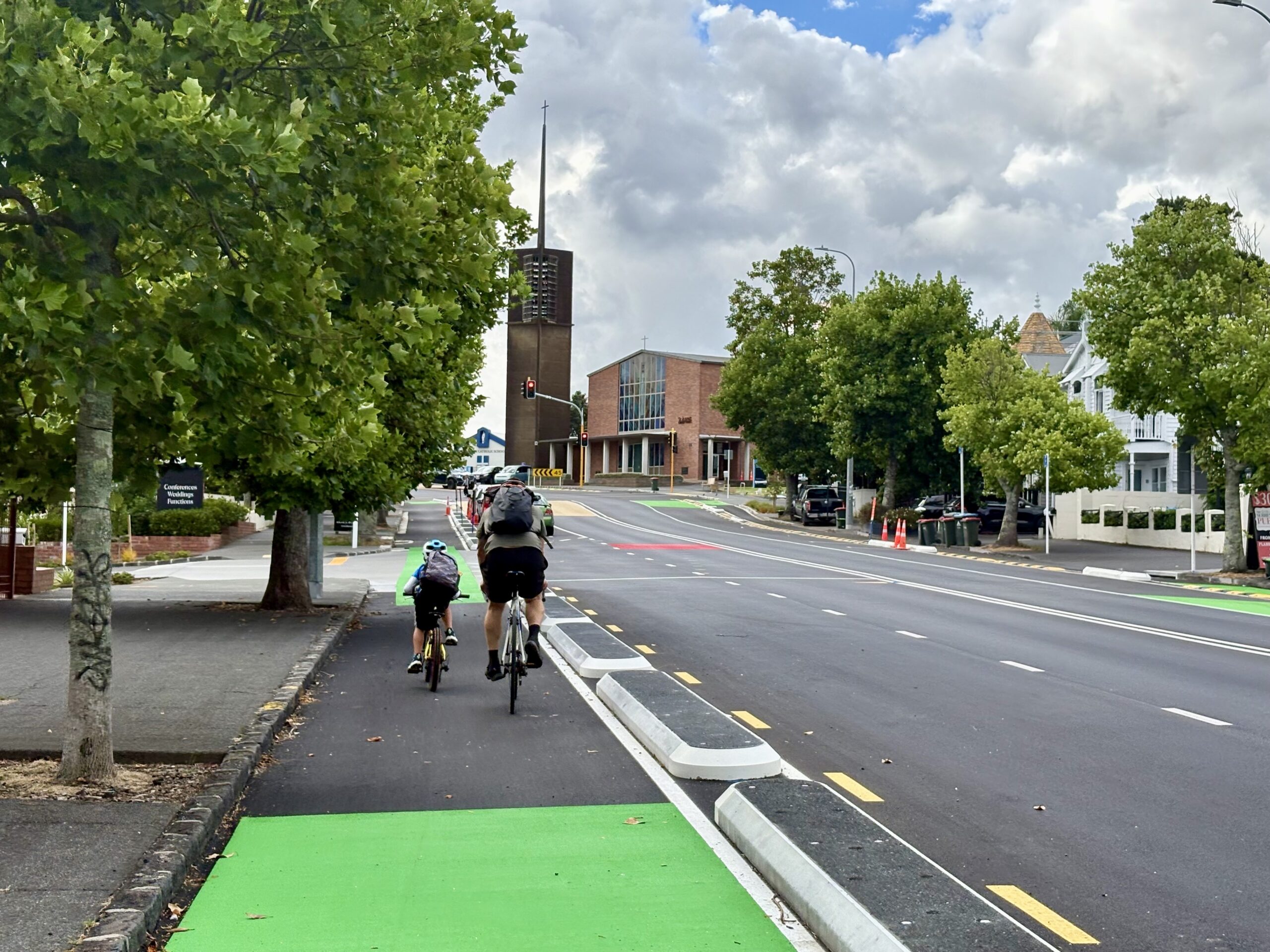
Parent and child using the new protected bike lanes on a major arterial route: Great North Road, 2026. Image: Jolisa Gracewood
What if we freed up our streets again? A guest post by Tommy de Silva, September 2024
True, urban spaces built for people are still the exception and not the rule in Auckland – most places still prioritise planet-heating but paradoxically air-conditioned gas guzzlers. But change – like a bike lane down every major road, safely walkable streets in town centres (and everywhere else for that matter) and frequent, reliable public transport servicing more areas – will inevitably come, as the realities of the climate, economic and equity crises set in.
By shaping the city, we shape ourselves, by Connor, June 2025:
It’s important to note this power to shape our city isn’t limited to the hustle and bustle of the City Centre, nor around these transformational projects like CRL. Auckland is famously a city of connected villages, and each offers a burgeoning opportunity to transform our local streets from rat-running paradises rumbling with vehicles driving past, to quiet cul-de-sacs alive with the sound of birdsong, rustling leaves, kids playing, and the chatter of neighbours.
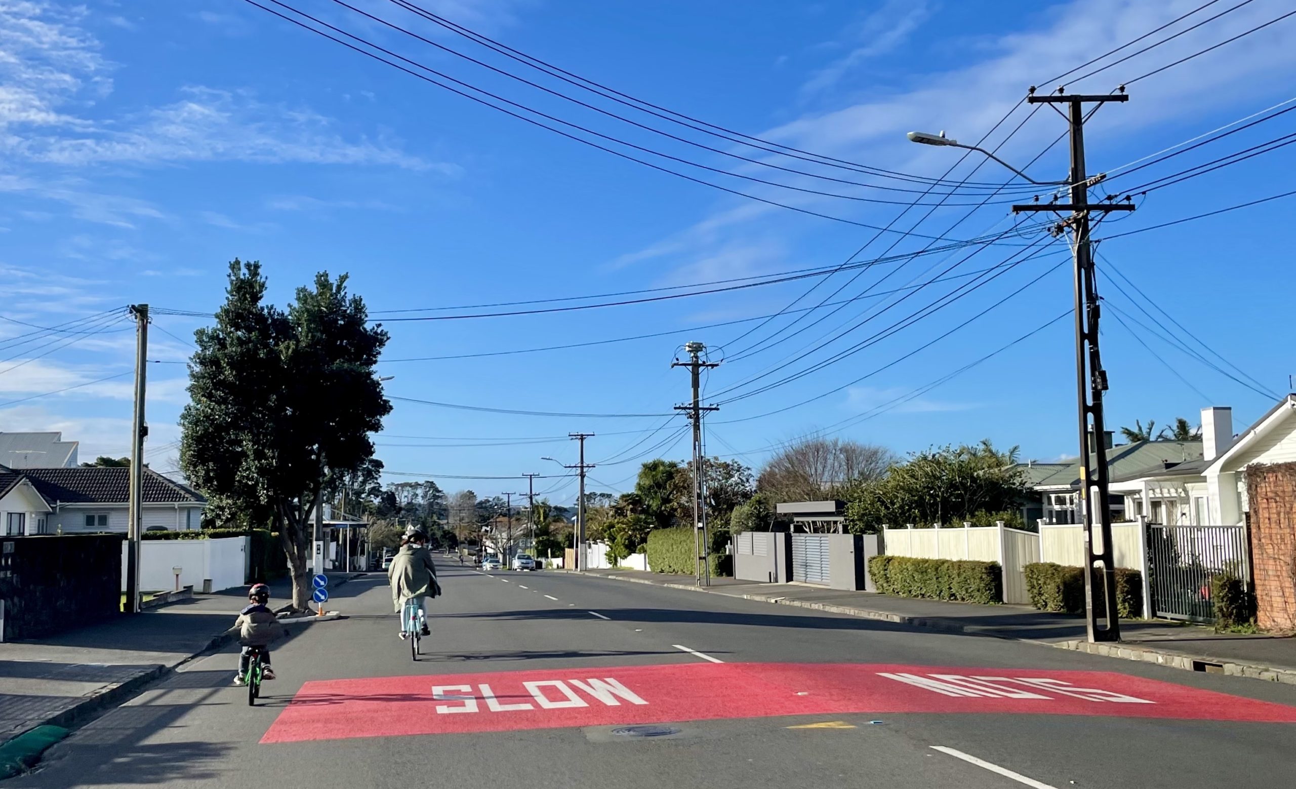
Biking on a quiet but otherwise arterial road: September 2021, but it could be any time we want. Image: Jolisa Gracewood
Greater Auckland’s research and advocacy is powered by hundreds of hours of work each month, and your support helps keep us going! We warmly welcome your donations, and are always open to offers of guest posts, practical help, and pro-bono expertise.
Another great way to support the kaupapa is by purchasing and wearing our Greater Auckland merch. Allow a week for delivery – and remember these are print-on-demand (no returns), so double-check your sizing before ordering!

 Processing...
Playable streets sound sub-optimal but perhaps worth hassle where parks are not proximate or suitable (e.g. it would unfortunately be very irresponsible to encourage children to use Myers Park until something fundamental changes …)
More important to grapple with is our need for more shared space and parklands in the face of the urban degeneration fostered by our intensification policies. This is a problem being kicked down the road.
3-30-300 rule – 3 mature trees visible from every dwelling, 30% canopy cover in every neighbourhood, and every dwelling at most 300 metres away from the nearest park or green space.
AC should be buying up lots to turn into parks roughly 300 metres from each other
If love to see some mapping on this. I think 90+% of sites in almost any suburb would achieve the 300m
My daughter and friends enjoyed the Karangahape Rd events on Saturday -unfortunately as you mention the road was still open to traffic- meaning when they came to come home their WX bus took ages to get along the road and onto the motorway -obviously meaning there were no connecting buses still operating at Te Atatū.
Please don’t post links to Instagram, or other social media. I block all these – particularly Meta – in my browser.
Thanks!
Queen St was fantastic on saturday during the day with the Diwali celebrations. Would love to see that section of Q closed every saturday for markets and stalls!
K Rd was sick on saturday afternoon, seeing all these people dressed up coming in and out of the station was spectacular.
Then it was absolutely frickin lit at night, still hundreds of people hanging around when I left at 4:30am lol.
Then the marathon runners started to come in as we all left.
It felt like the culmination of a decade of struggle coming to fruition.
Still more to do but my god,
Auckland is so back!!!