Last week’s announcement that the Government plans to punt a decision on the next Waitematā Harbour Crossing out beyond the election included an offer – or a barbed hook, depending on your point of view – to Mayor Wayne Brown.
The Mayor remains inexplicably fixated on the notion of building a road bridge from Meola Reef to the North Shore. Perhaps in effort to finally put it to bed, the Government is offering to co-fund one more study. To the tune of a million dollars, as long as Auckland Council puts up half.
What’s another million bucks, when $106m has already been expended on reports from consultants? On the other hand, the idea has been discounted several times already, making this a pretty expensive and pointless sop. As RNZ notes:
An extract from a July 2025 briefing by NZTA on the Meola Reef option, that was released under the Official Information Act, showed that option has had multiple studies since the 1990s, and was discounted because “it doesn’t address the issues of resilience, growth and public transport reliability”, would have “severe environmental and community impacts with poor terrain to negotiate and highly developed urban areas”, and it was “highly likely that poor ground conditions beneath Meola Reef would still require deep piles to support a bridge pier or causeway”.
Moreover, the NZ Herald reports that councillors from across the spectrum aren’t keen; and the Mayor himself says it would be “ridiculous” to spend that money.
So far, we haven’t analysed the Mayor’s idea, because there really isn’t anything to analyse: no actual proposal, just a location. But in the interests of helping save everyone a million bucks, let’s walk through the basics and ask if there’s any value in it at all?
Spoiler: No, because – and this may surprise you – we’ve already built the thing he’s describing! And there’s a better location for a brilliant bridge. Read on for more…
The Problem Case
First things first: let’s reiterate the problem to be solved, as we’ve already covered in detail. In short, and in this order:
- Add the missing modes between the Shore and the City Centre
- Provide resilience for the current ‘single point of failure’ on SH1
- Alleviate the network imbalance
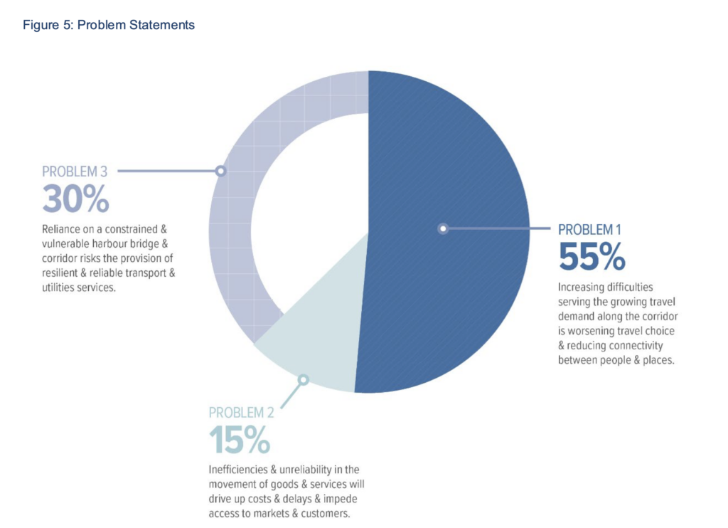
Harbour Crossing Problem Statement, from NZTA’s Strategic Business case 2020.
Critically, these issues occur specifically between the North Shore and the City Centre, along SH1.
A huge highway network design flaw, which we are stuck with, is the way SH1 traffic is routed via the Auckland Harbour Bridge and thus is funnelled through (the edge of) the central city.
This pressure is somewhat relieved by the Upper Harbour crossing and SH18, which togethr with SH16 form the Western Ring Route (WRR) – an important bypass for regional and inter-regional traffic, as well as providing local access to the west and northwest.
But the WRR doesn’t really address the critical demand axis, i.e. the fact that so many people want to travel between the City Centre and the North Shore.
Even so, it is one of three very clever interventions that enable the now 70-year-old Harbour Bridge to still function as well as it does despite its glaring deficiencies (most obviously, the mono-modality – that you can only cross the harbour in traffic).
Those three interventions are:
- The clever movable barrier, enabling tidal lane distribution
- The Western Ring Route bypass
- The Northern Busway plus Onewa Rd buses, relieving up to 50% of peak direction demand to the city centre.
So, the first problem with the Meola Reef idea – if it were even buildable – is that it would essentially add a second Upper Harbour Crossing. A Middle Harbour Crossing, if you like. A bypass for some vehicle traffic, for a minority of trips not using the key demand axis. It simply doesn’t address the core of the problem case.
And for a project of this magnitude, with a budget of the expected magnitude, we really need something that fully addresses the actual problems, otherwise we’re throwing precious money away.
But for argument’s sake, let’s set that point aside, and take a deeper look at the location, to highlight why the Mayor is “not even wrong”. Or indeed, why he’s quite right – just looking in the wrong place.
The Meola Axis
The thing about this idea, and what presumably makes it so very sticky and hard to let go of, is that it is primarily an engineering-led idea. It “makes sense” in a technical sense, when looking at a map rather than the full picture.
Which is to say, because of the shape of Meola Reef, this place looks like it might be an easier location to add a crossing, from a constructibility point of view.
Even though this is a relatively wide part of the harbour, the 2km reef, formed by a lava flow from the Mt St John eruption, is visible at low tide, making this look like an easier place to cross – as clearly visible below.
(The tantalising nature of this possibility has been around for a very long time, as is clear from the story of the patupaiarehe attempting to build a bridge from one shore to the other in one night.)
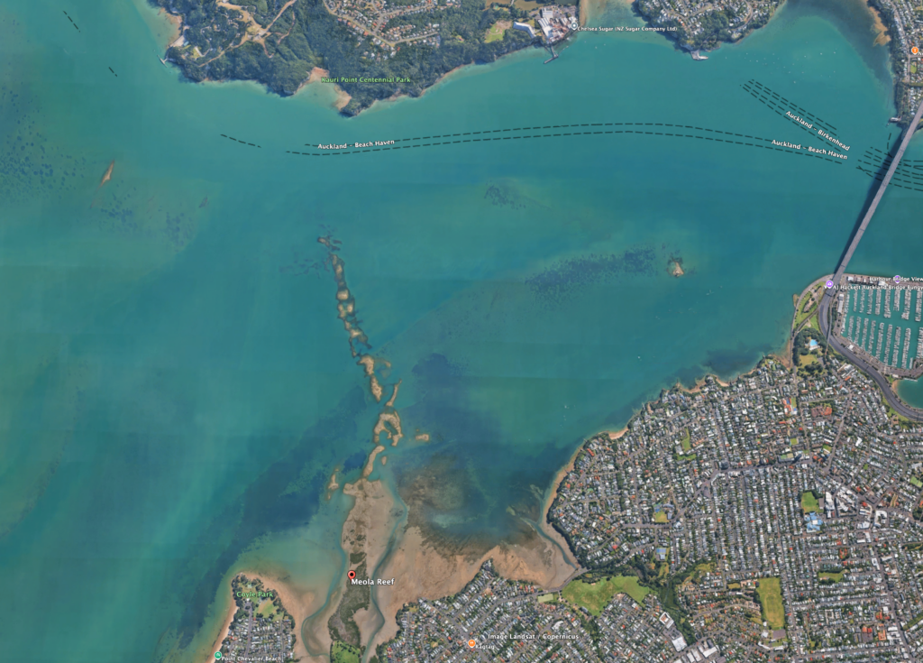
Meola Reef, as seen on Google Maps.
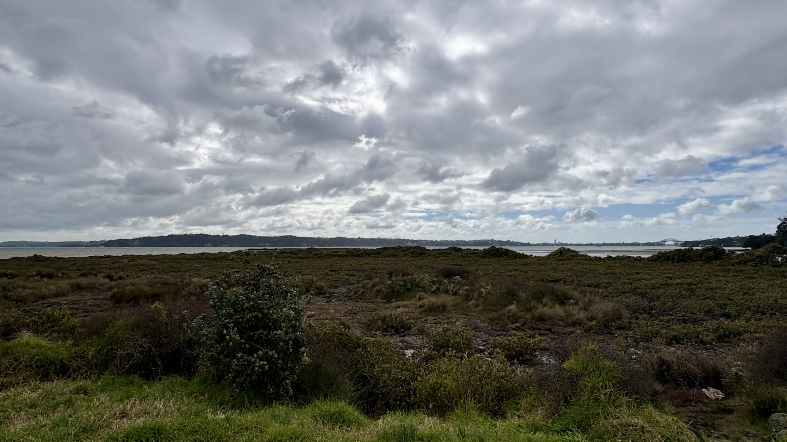
From Meola Reef / Te Tokaroa Reserve, looking out across the lava flow towards the North Shore. Photo by Jolisa Gracewood
Beyond the reef itself, there is another 700-1000m of deeper channel to span. And then there is the question of how useful a layer of basalt over mudflats actually is to build on, it has been described as a Crème Brûlée – a thin crust on soft mush.
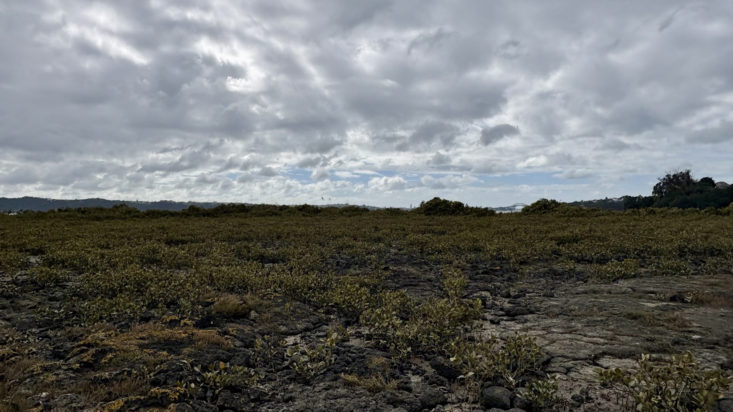
Standing on the lava flow at the top end of Meola Reef Reserve/ Te Tokaroa. Photo by Jolisa Gracewood
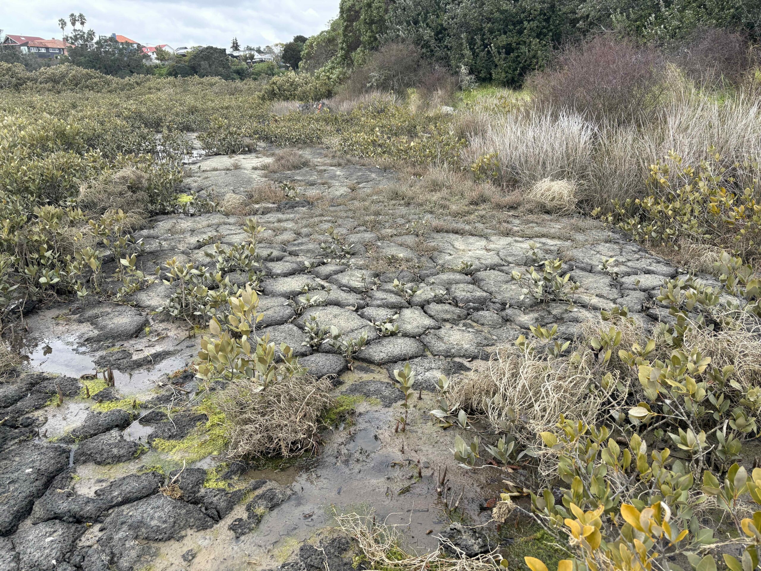
Mmmmm, crème brûlée anyone? Photo by Jolisa Gracewood
Geology aside, there are many other concerns. What is on either side of this route? What would it connect to? Which modes would use it? And does it actually address the key problems?
So let’s take these in turn.
The Mayor’s route would connect Western Springs/Pt Chevalier on the south side to the cliffs of Kauri Pt Centennial Park, the Chatswood subdivision, and the Defence Armament Depot, then the wider Kaipātiki region.
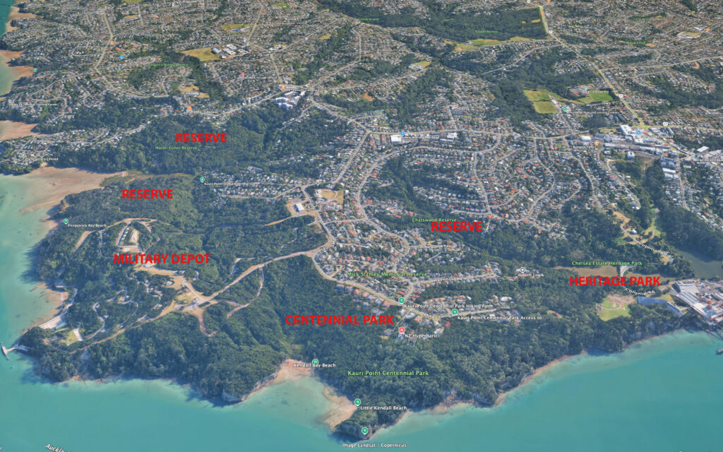
Kauri Point and environs, where the putative Meola bridge would land.
And here’s the southern section, showing Meola Reef Reserve – which includes a popular off-leash dog park – covering a capped old rubbish dump.
Then, on the south side of the recently rebuild Meola Road, you have MOTAT 2 and the Seddon Fields sports grounds, two schools (Western Springs College and Pasadena Intermediate), the Auckland Zoo, and the much loved Western Springs Park, with the new Auckland Bowl stadium arena.
The reef itself is flanked by two waterways: Meola Creek/ Waitītiko, and Waiōrea/Motions Creek (not named for what you think!).
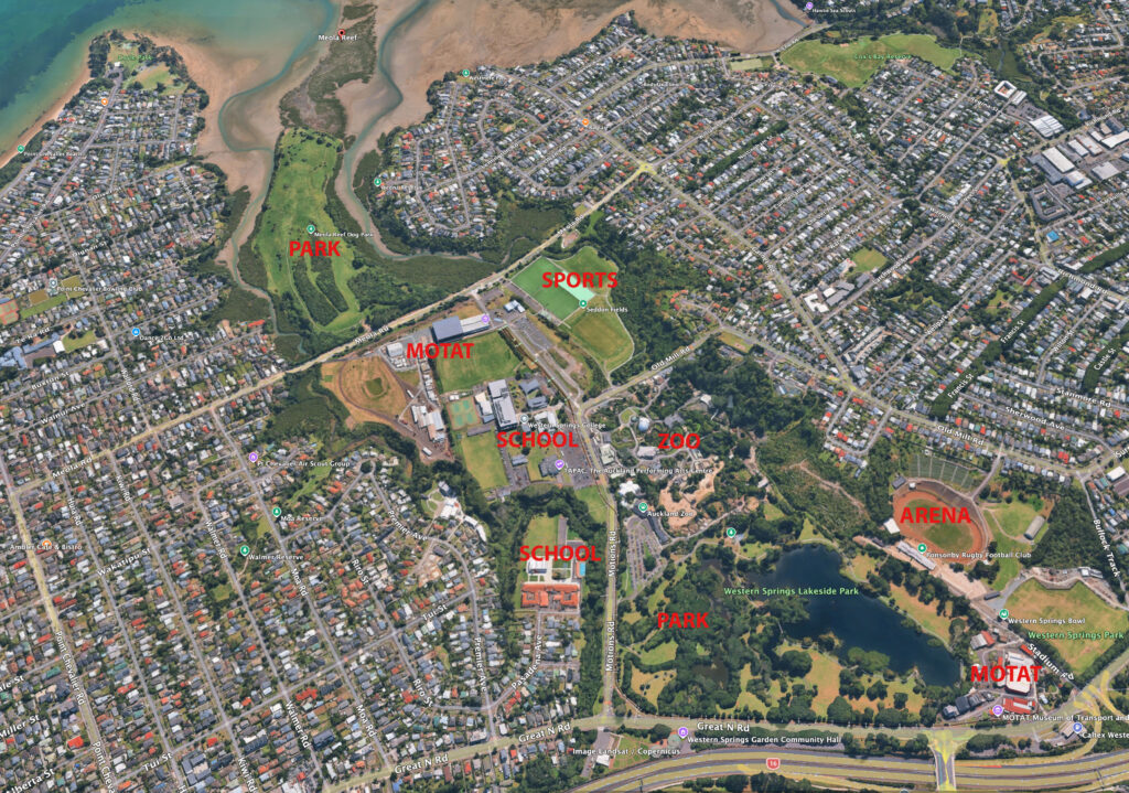
Meola Reef, flanked by Meola Creek and Motions Creek, showing existing amenities and surrounding suburbs.
A Brief History of the Meola idea
So where did this idea come from?
Actually it is from the very Ur-text of Auckland transport planning, the 1965 De Leuw Cather Motorway Plan,
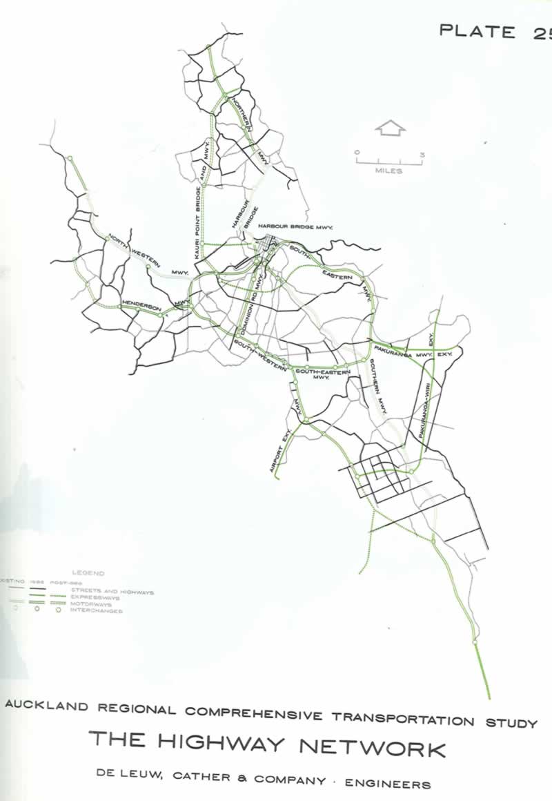
A page from the 1965 De Leuw Cather & Company Highway report.
There it is! The Kauri Point Bridge and Motorway.
But there are two important things to be aware of here.
Firstly, there are many proposed motorways on this plan (due for completion by 1986) that were never built, and never will be built (Dominion Road, anyone?).
More to the point, there is one motorway not on this plan that we have built.
That’s the Upper Harbour Motorway, SH18, including the Upper Harbour Bridge (as shown below), which links SH1 north to SH16, and connects to SH20, to make the Western Ring Route. (See Wikipedia, and also NZTA for a short history).
So this is key problem with the Mayor’s idea, we’ve already done it! A traffic bypass for the Harbour Bridge has been built as envisaged – but just on a more northerly alignment, tucked in behind Hobsonville Point. And it’s effective for serving inter-regional and intra-regional vehicle journeys looking to bypass the central part of SH1 over the harbour and through the city.
It’s already there, having been built over many decades and at great expense. We are not going to do this again.
The road networks
Here’s the wider picture, showing SH18, the Upper Harbour Crossing, and the Western Ring Route:
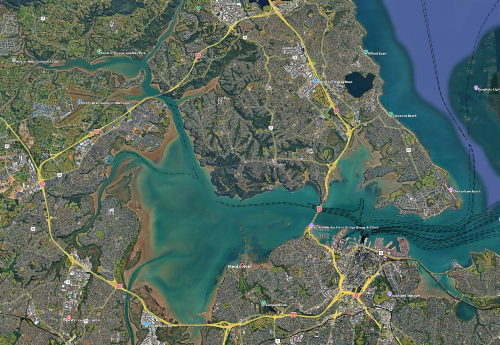
Waitematā Harbour and State Highway network
What would a Meola crossing – if it were even technically possible – add to this picture? More connection to State Highways? A sort of middle rung?
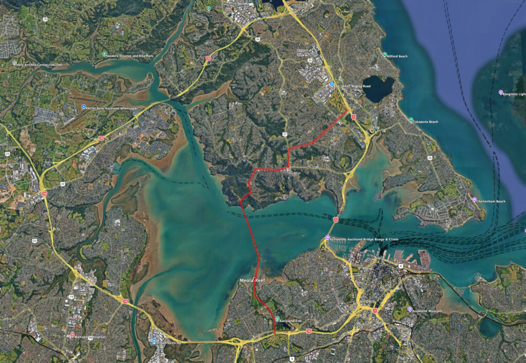
Meola Crossing to existing motorways – what’s to be gained, exactly?
On the southern side, the reef is only about 2km from SH16, which looks appealingly simple on a map. However, actually connecting to SH16 anywhere in Western Springs is unworkable, as there is nowhere for the necessary interchange – and this would pour more traffic onto an already full motorway. The network effects would be chaotic, and the local impacts horrendous.
To the north, any bridge would land on the edge of nowhere, and many difficult kilometres from the state highway network.
Furthermore, on both sides the land is already intensely used, in one way and another. So quite apart from the issues with distance and geography, there is literally nowhere to add more connecting motorways on the surface.
And tunnelling this route instead would surely defeat the cost-savings that seem a major motivation for the Mayor.
Which is not to say that hasn’t been considered (and chucked out) already! In 1997, the Meola axis made it onto a shortlist of crossing options – see below, where options 9.1 and 16 are sketched out as extremely long tunnels connecting into the motorway network. Let’s get serious: just as tunneled light rail across the whole isthmus wasn’t viable or affordable, no way would this have been either.

All right, you might think, no tunnels no how, and no room for new motorways on either side. Then how about just connecting into existing local roads?
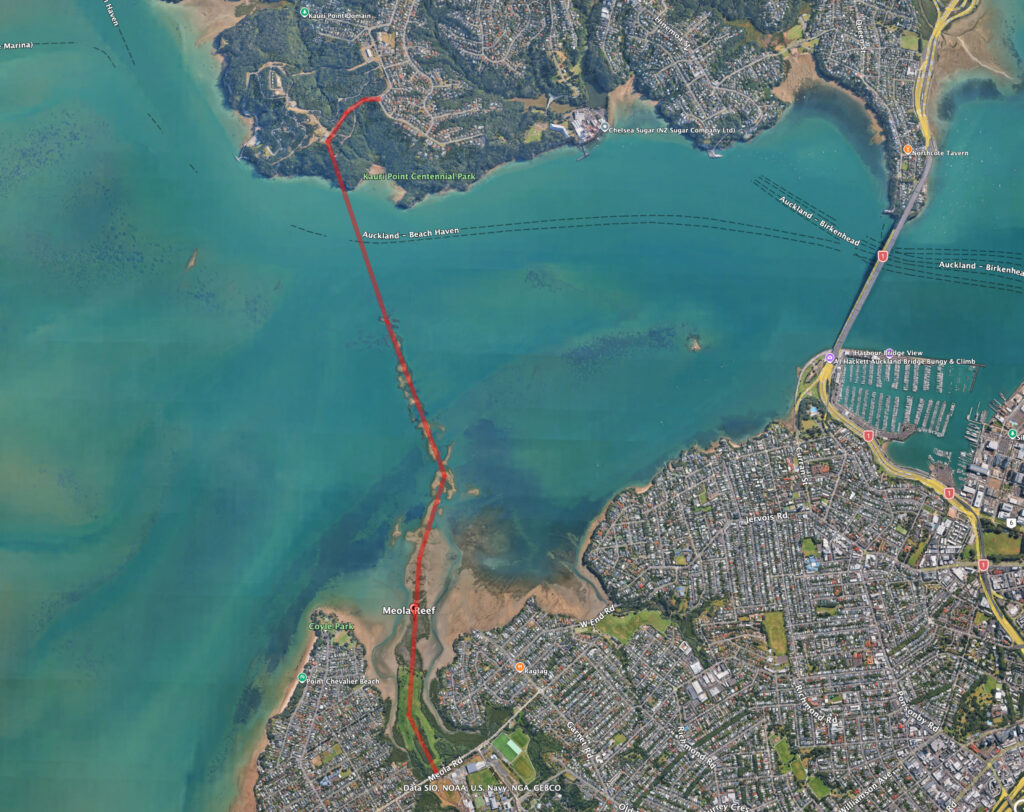
Meola Crossing to local roads
The above sketch shows a 5km crossing from Meola Rd on the south, to Onetaunga Rd on Kauri Pt, via the Military Depot (avoiding Centennial Park).
These are minor one-lane-each-way local street networks, suitable for residential suburbs. So, either those streets and neighbourhoods would be completely overwhelmed with traffic, or the bridge would achieve very little in terms of effective transport outcomes. Probably both; truly the worst of both worlds.
Moreover, to the south, as already noted, there are parks, schools, a museum, a zoo, and sensitive ecologies. On the northern side there are cliffs, parks, a military base, and residential suburbs to negotiate.
All of this helps explain NZTA’s disinterest in this location. There’s no chance of efficiently connecting into the motorway system, let alone delivering the missing Rapid Transit route between the spine of the North Shore and the City Centre.
So the Meola axis simply doesn’t address the three key needs of the next harbour crossing.
On the bright side: if you could consent, fund, and build it, this axis could make for a very pleasant recreational walking and cycling route over the harbour.
On the other hand: if a Mayor had a whim to build something like that, as his legacy – surely it’d smarter and more achievable to secure funding for finishing something that’s already under way and wildly popular, like say Te Whau Pathway? Plenty of places around town where a spare million bucks wouldn’t go amiss.
What about housing?
In interviews, the Mayor has claimed that his idea would unlock land currently occupied by the military depot on the North Shore, enabling it to be converted to housing.
There is no information on whether the military are interested in selling this rugged site for housing. In theory, if available, it likely could support some housing – as any land could – but how much isn’t clear. Nor is it immediately obvious that such a bridge would be necessary to achieve this.
The larger point is that this would be exactly the sort of out of sequence housing growth that the Mayor has been quite correctly opposing for some time. The land in question is not within the area covered by the Central Interceptor or the Rapid Transit Network that he has rightly been promoting as the right places for housing development.
Look at what’s possible: the Waitematā Bridge
But really, please, can we move our eyes back towards the real problem, and seize the true potential here. Instead of wasting a million bucks on a repetitive report to no good end, the Mayor and Council have a much more meaningful opportunity to assertively intervene in this conversation, and make a real difference to the outcome for Auckland.
The Government has said it will assess “market-led proposals” in the new evaluation process.
We believe that must include the bridge proposal we are backing, as described here, and as presented to Council, here.
This proposal meets the problem case fully, and at the lowest possible cost. It gives our city a beautiful new icon to grace its glorious harbour, for us all to experience via every mode of travel. And it’s future-proofed for any future rail system to the Shore.
All it needs is confident and tenacious political champions who can sing of its value, as Len Brown did with the CRL.
The Waitematā Bridge in a nutshell
The proposal is for a new six-lane bridge across the harbour, designed to work in conjunction with the existing harbour bridge to separate motorway and local traffic, while also adding rapid transit and bus lanes, and walking and cycling paths.
It’s aimed at adding the missing modes while also adding missing counter-peak capacity to the state highway. The plan balances the lanes either side of the harbour and separates city commuter traffic from motorway through-traffic, providing resilience and the ability to manage lane closures better.
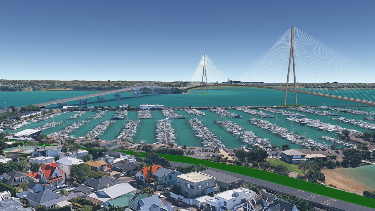
The proposed Waitematā Bridge, as backed by Greater Auckland. More here.
There is one thing we do wholeheartedly agree with the Mayor about: it’s bonkers that NZTA insists any additional bridge crossing has to be strictly parallel to the existing one.
We have never been able to make any sense out of this, especially as it seems to make the whole idea of a new bridge both less desirable and effective. Why on earth would you further pave over St Marys Bay and Northcote Point, when you can just skip them both by swinging a little to the east and using a shorter and more direct alignment?
Funnily enough, this more sensible alignment appeared in an earlier official proposal (from 2008?), albeit with a wholly unnecessary and absurdly large interchange at the city end (likely due to an obsession with tunnelling under Victoria Park).
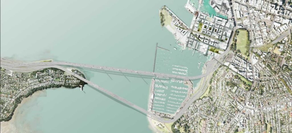
NZTA/BECA 2008 https://www.greaterauckland.org.nz/2019/06/05/a-history-of-harbour-crossing-options/
Whereas, the proposal we endorse takes the far simpler approach of tying in with the existing viaducts, having sailed over Westhaven, preserving St Mary’s Bay and leaving Victoria Park undisturbed.
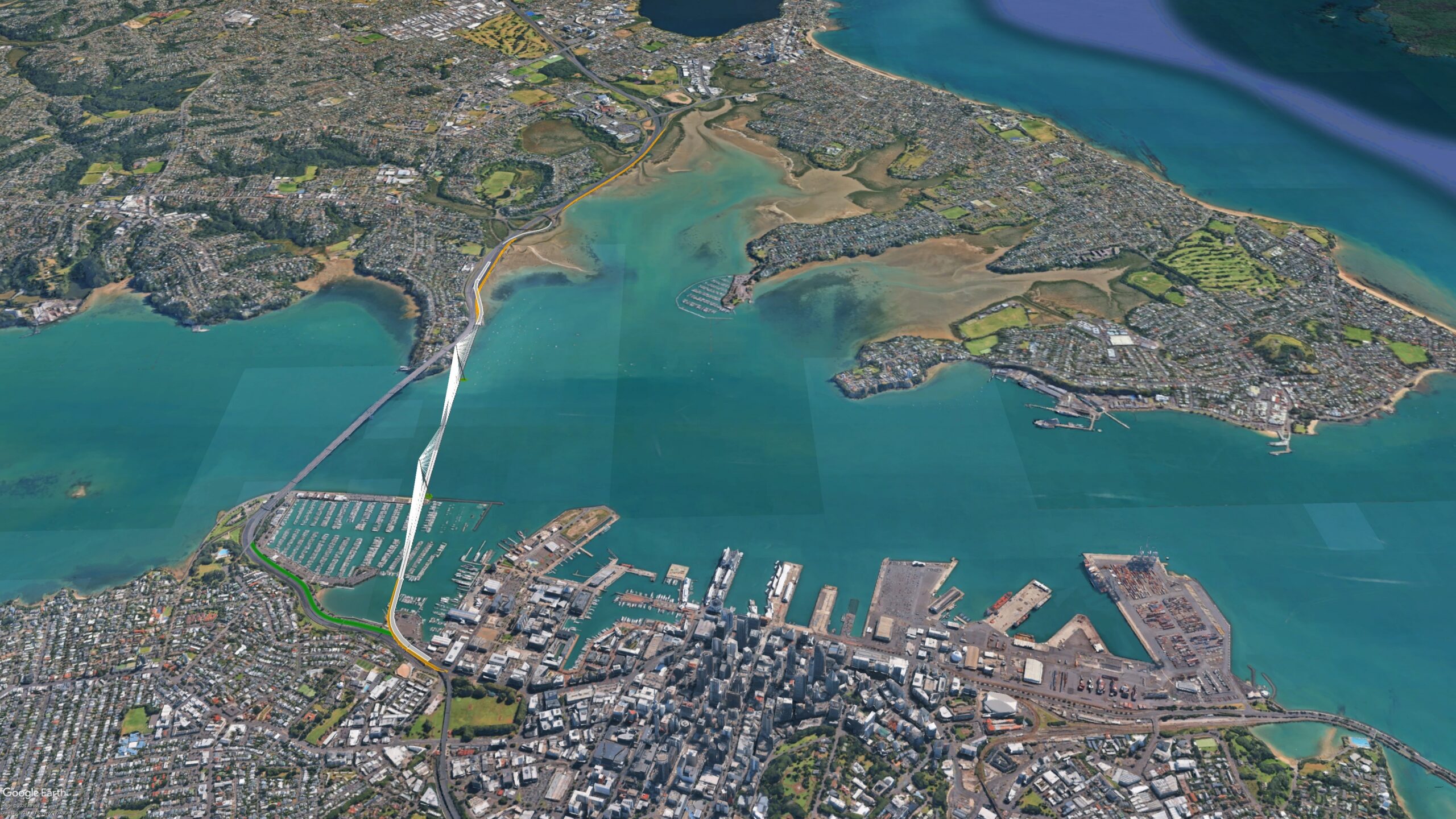
The Waitematā Bridge – not parallel, but landing to the east of the current bridge. Image: Nicolas Reid/ MRCagney
If the Mayor can see his way clear to letting go of the Meola notion, and guiding Council towards the more practical solution to the existing problem statement, then we’ll finally be getting somewhere.
Done
Ok who do we send the invoice to? $1m, 50/50 government and the Mayor’s Office? Anyone have the purchase order number?

 Processing...
What would be good is if our local and central government representatives could learn from the past. Along with realising that what they decide for projects of this size will not bear fruit until they are possible long gone.
Look at the CRL. 100 years to get something built that was obviously needed for all that time. True what we ended up with is different to what was first planned but that’s because we waited so long things needed to change.
In any case please can we all agree this is for next generations and deal with not being able to cut the ribbons.
Also who ever decided to put red text on green needs to remember there are colour blind people.
In fact the first official study of the Meola Reef bridge idea was published by the Auckland Harbour Bridge Authority in 1974. Freeman Fox (designers of the original harbour bridge) were commissioned to investigate that route and produced a 58 page report. They in turn hired local engineering company to investigate the geo-technical issues. T&T drilled 9 test bores through the northern part of the reef verifying that the hard basalt of the reef was 3-15 metres thick, but tested on many metres of soft marine mud and sandstone so any structure built over the reef would need deep piled foundations anchored in the underlying Waitemata series bedrock, though they figured that the reef would provide lateral stability. So, rather than offering the narrowest part of the harbour to bridge builders – this is actually one of the widest. The proposed bridge would have a main span of only 300 metres but with associated viaducts North and South the overall structure from Meola Road to Balmain Road would be about 5 kilometres. Curiously Wayne Brown claims that existing roads could handle the traffic which is obviously nonsense. There is no point building a crossing unless it is going to carry tens of thousands of vehicles each day, well above the capacity of the local network. So up to 15 kilometres of new motorway connections would be required and a new interchange with SH16. Nuts.
Actually do send the invoice along with a nicely printed and bound copy of the above. Send copies to Granny Herald and all the usual outlets with a copy of your invoice and challenge Brown and Bishop to show what further information would come from their $1m consultancy spend. Call it out any consultancy that takes on this gig as having their snout in the public trough for no good or justifiable reason other that Brown and Bishop seem intent on having a $1m Mexican standoff at our expense and someone might as well collect on it.
In fact there was a far earlier study commissioned by the Auckland Harbour Bridge Authority in 1973-74.
Would be a great idea to have a major motorway going pass a Defence location stacked with high explosives…not!
(as well as all the other reasons)
If it’s not already in their radar a few emails to Chris Bishop, Mayor Wayne Brown, and local councillors about this bridge proposal could be helpful to secure support
On the point of Council paying for this – every cent of Council expenditure requires authorisation in one form or another. Usually this is done either through the publicly consulted LTP (Long Term Plan) or a specific resolution of the Governing Body (or one of its committees acting within its delegated powers) to authorise an item of “unbudgeted expenditure”. Senior officials have access to “discretionary funding” to approve relatively minor spending (usually capped in the thousands) themselves rather than clutter agendas and meetings with trivial decisions. The Mayor also has discretionary funding, nominally to run his office (largely to pay his staff, but also for things like travel and professional advice from consultants). Last year he spent a record-breaking $4.4 million, but I very much doubt that he can draw on a spare $500k from this source which is presumably already pre-allocated. If Wayne Briwn attempts a “swiftly” to sneak this item through in Council’s name without explicit Council approval I expect the Chief Executive to be dragged into a messy and public argument.
Already seen some stories that it will come from the Mayor’s fund.
Good post.
Why do politicians insist on promoting “solutions” before actually defining and prioritising the actual problems to be addressed.
The first PROBLEM is that capacity for moving even more PEOPLE across the harbour on the existing bridge using the existing mix of modes is finite.
But the current mix of modes is not inviolate.
And even the actual modes could be varied.
The second PROBLEM is lack of resilience of a single structure, and partial lack of availabity during inevitable maintenance.
The harbour crossing cannot be looked at in isolation from the scarce land at both ends. The defining failing of the Meola proposal.
But also a failing of at least the same magnitude, of any proposal based on just increasing motor vehicle capacity.
The current roads at both ends, are already near capacity and there is zero land available for wider roads without wholesale demolition of high value residential and commercial occupancies.
And more motor vehicles require more daytime storage, thus diluting the extremely scarce land available in the CBD for far more productive commercial activity.
Perhaps Bishop’s study, is just a politically expedient of appearing to do something, when really the current best thing is just more buses and more bus priority.
Can somebody in the Mayor’s office put this in front of him. How can an engineer not have read the previous reports?
I agree with this article – Meola bridge makes no sense when compared to a bridge aligned with the currently Auckland Harbour bridge corridor in the manner described above.
But taking a step further back this additional Auckland harbour crossing process of starting with the ‘what project’ rather than ‘how will it be funded’ question is very distorting, inefficient and relies on bad faith arguments.
An example of the bad faith argument is Wellington politicians like Nicola Willis the finance minister come down to Canterbury and said we could get our fair share of transport spending (i.e. what we contribute in transport taxes to the National Land Transport Fund) if only all parts of Canterbury collectively support without division a particular set of new transport initiatives. Yet for some reason Auckland (and other regions) are not held to this high standard. The government and finance minister is willing to spend $100m (from general taxes) on investigative studies for the additional crossing. I know in the future the next excuse for not building transport projects in Canterbury or the South Island will be the excuse that the detailed design or business cases have not been done.
P.S. I am a supporter of Auckland and especially the congestion free network. as a nation we should have created processes that allowed this to be built decades ago, especially in the big growth phases after WW2. I think Cantabrians making JAFA type comments are another example of bad faith arguments. But once the bad faith pandora box is opened…
I don’t see how paving over some of Auckland’s few remaining inner city reserves will somehow make the city a better place to live
A few more fun facts about this route: that the entire road between Birkenhead and Verrans corner sits at almost 100m elevation. If you pick a random bit of street in that area you can expect it to have a slope of over 5%. In comparison, Ponsonby is flat as a pancake.