With Mill Road back in the news, as a campaign headline from the National Party (see our Tuesday coverage), it’s the perfect time for a look back at our previous coverage of this overscaled project.
The post below, by Harriet Gale, first ran in February 2018, and attracted vigorous discussion, with over a hundred comments. It was followed in March 2018 by a post from Matt Lowrie outlining a sensible quick fix.
We revisited the topic in late 2020, after the project was revived as part of Labour’s New Zealand Upgrade Programme. Once again, we questioned the need and pushed for a rethink (December 2020), and followed up by proposing a sensible and affordable alternative (February 2021).
The cost of the proposed project continues to soar, along with average temperatures and the likelihood of dangerous weather events – but our prescription remains the same.
If you really want to improve things, fix the risky intersections, and expand and improve the bus and bike connections. Job done, with plenty of funding left over for other far more urgent priorities, in transport and elsewhere.
NOTE: the following post was first published in February 2018. Minor editorial corrections have been made. Some external links and materials may no longer be available. Just as well we save the receipts!
One of the projects that has come into the spotlight again recently is the Mill Road corridor project. At the moment it is split into two key projects, though each contains several distinct sections:
- Mill Road North – This is the project that bizarrely topped the RLTP priority list, despite costing over $500 million. The northern section of this is actually along Redoubt Road, and involves capacity upgrades to the existing road, partially to cope with growth in Flat Bush. The southern section is basically a de-facto expressway with two viaducts and a largely offline realignment from Redoubt Rd to a paddock in Popes Rd (Takaanini);
- Mill Road South – From Popes Rd all the way to Pukehoke, via Drury. The RLTP costed the two separate Takaanini to Drury sections at $700 million alone. Given it is another 10km plus to Pukekohe, this will probably cost about as much money again.
This could put the total cost of the project at an astounding $2 billion, and possibly much more given further required arterial road connections. Therefore, a very high degree of scrutiny is required of the reasoning for each section of the project.

The South area of TFUG [ed: Transport for Future Urban Growth, now known as Te Tupu Ngātahi/ Supporting Future Growth]. The Mill Road Corridor is number 7.
I think the Mill Rd corridor needs upgrading, but it would be remiss if we didn’t go into the many flaws of the project, mainly around the northern section which is fixable.
De Facto Expressway
The big problem I have is the cost, which is between $800 million to $1 billion. This is caused by the fact the current design is a de facto expressway with major offline realignments, as well as two viaducts. It seems like Auckland Transport is trying to do a RoNS [Road of National Significance] of their own!
Interestingly, just like some of the RoNS, this also has a major impact on a significant stand of native bush, and was subject to an appeal by Forest and Bird amongst others.
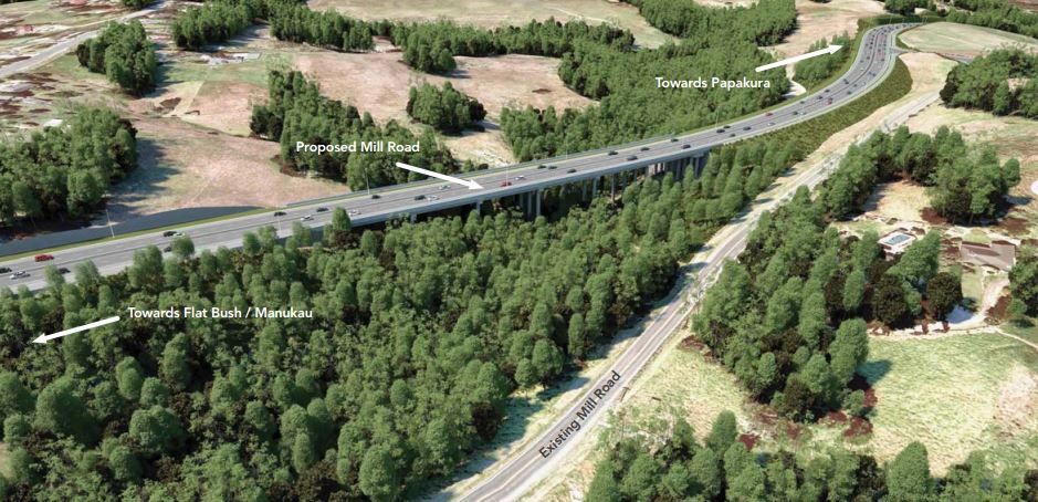
New proposed Mill Rd Viaduct parallel to existing Mill Road
Just like many RONS projects, the existing corridor has many issues, including safety. I question if the project needs to be so gold plated, and I feel we could fix much of the problem by upgrading the existing road to more suburban arterial level than an expressway. This could be done in a more staged manner, and save many hundreds of millions of dollars, while actually delivering important safety improvements.
Also again, what is with Auckland Transport’s obsession with flush medians. Seriously, I am half expecting the Dominion Rd Light Rail design to have a flush median between the two tracks! So strange having wide flush medians, where there are no driveways, just a pointless added cost!
Poor Cycle Design
There are also issues with some of the more detailed design areas of the proposal, with one of them being the cycle infrastructure proposed. The cycling is well behind what it should be for an upgrade of this size. The following is a typical cross section for the high speed rural section.
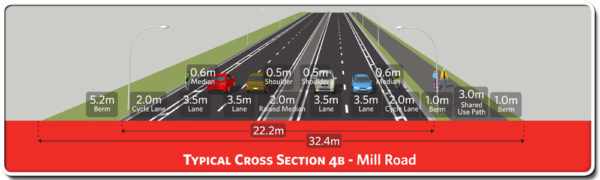
- Why are protected cycle lanes not included? The cross sections show 2.0m cycle lanes plus a 0.6m buffer. On a residential street this would be acceptable [Ed: in fact, AT’s design standards require physically protected lanes at speeds above 30km/h], but on a road which will be 80 or 100kmh, paint-only separation is just not acceptable;
- The wide corner radii on side streets means that speeds [of vehicles moving] on and off side streets will be high, which is not good for people walking or cycling;
- Instead of making the cycle lanes protected they also add a shared path on one side for vulnerable users. Here is a better idea, just do it properly!;
- The roundabouts here will be dangerous for those walking and cycling, especially with the turning radii conducive to speed as well as double-stacking lanes. To be honest in this high-speed environment, even a Dutch at-grade cycling design would not be safe – and given the roundabouts are being built from scratch, surely grade separation of cycling/traffic should be strongly considered;
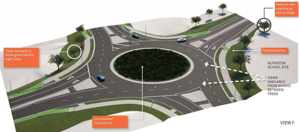
Mill Road Roundabout, as proposed
Bus Infrastructure
The project talks about bus infrastructure – but this doesn’t need a Mill Rd Expressway to deliver. It feels like PT-washing, to make the project sound more multi-modal. No bus services are proposed along most of the corridor, and it is not a sensible place to run buses given the street network.
The improvements referred to below all occur in the urban section of the corridor closest to Manukau City Centre, where changes are welcome but only cost a small fraction of the major changes further south.
- Public transport improvements to the Mill Road Corridor will provide more frequent and more reliable public transport services. Bus priority facilities will be provided at the Hollyford Drive/Redoubt Road intersection, including a dedicated right turn lane for buses turning out of Hollyford Drive into Redoubt Road.
- A new west-bound bus lane is proposed between Hollyford Drive and SH1 intersection. The proposed bus lane will allow buses to travel unimpeded between Hollyford Drive and Diorella Drive, and between Diorella Drive and the motorway.
Future Urban Land Supply
The latest Future Urban Land Supply Strategy has pushed back live zoning the future urban zone of Takaanini until the 2040s due to flood risk. This makes it basically the last area in the whole of Auckland that’s sequenced for greenfield growth.
Given that supporting the growth of Takaanini was the original key driver for the project, now that the area it is serving isn’t set to grow until much later, it now seems truly bizarre for this project to remain such a high priority.
Importantly, the priority for much of this corridor should be much lower than other areas, where infrastructure is needed to support growth that’s happening now.
The Big Issue – How do they connect?
This is the major issue with this project, and it has not been explained: how will the two projects actually connect, given there is a built-up area in-between?
The map at the start of this post indicates the plan is to upgrade Dominion Road (yes, there’s one in Papakura too), which makes sense as that is the only clear way to get from the north to the south between the two projects.
I guess this is the classic engineer’s trick: build two easy ends of something and people will inevitably ask for the middle to be done.
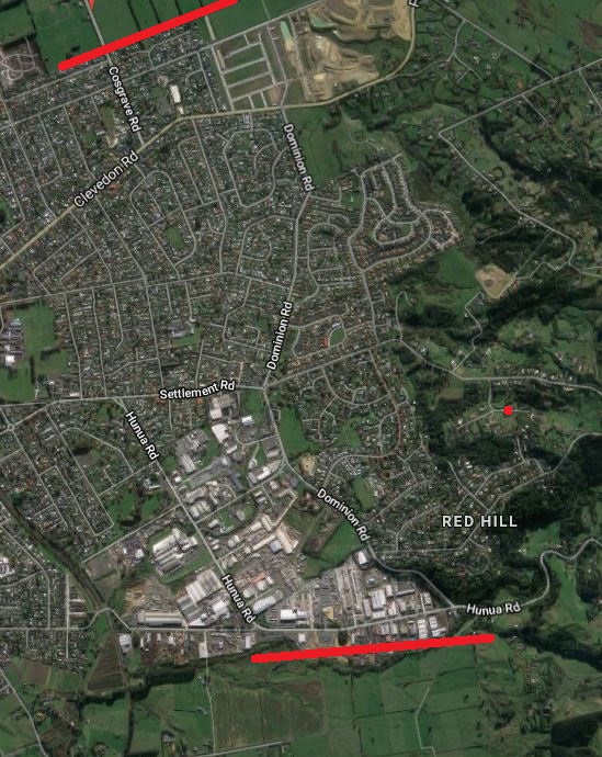
How do you get from one side to the other?
Dominion Road, Papakura, is currently a normal quiet residential street. Running a four-lane expressway down this road would be a truly awful outcome for anyone living on the street or in the wider neighbourhood. This is something we would do in the 1970’s, but is not acceptable any more. Linking via Dominion Road will also likely require demolition of dozens of brand new houses, which are seen on the aerial map above as the new street network, where houses have since been built.

Dominion Road today (Google Streetview)
An alternative solution
Again, the solution is similar to ones proposed for some of the RoNS projects. Mill Road should be staged as a variety of smaller projects, as the work does not need to be done all at once. As long as the corridor itself is protected from encroachment, and smart property purchases are made where needed over time, future options can be preserved while short-term improvements are made.
I personally think the best way to go about the corridor is:
2018-2028 – First Decade
- Upgrade the Redoubt/Murphys section of the corridor (closer to the Manukau/Flat Bush growth area), however, scale it down a bit as there are just too many lanes for a residential area;
- Smart safety upgrades on the existing Mill Rd between Murphys Rd and Papakura. This could include rumble strips, shoulder widening, curve easements, and potentially median barriers where appropriate;
- The Drury section –connecting the industrial area south of Papakura to the Ramarama interchange – should proceed, given the proposed heavy industrial area near the quarry (Drury South Crossing), the planned greenfield growth, and existing industrial and development east of Papakura. This is being funded through the Special Purpose Vehicle created last year;
- Safety upgrades for the existing SH22 between SH1 and Pukekohe, including any level crossing removals.
Post-2028 – Second or Third Decade
- Consider extensions towards to Pukekohe, if upgrading SH22 doesn’t make sense;
- Upgrade the Murphys Road – Papakura section (including Dominion Road) to be major suburban arterial standard.
[Editorial note: The link to the related video no longer works]
In summary
Something needs to be done about the Mill Road corridor, but some major changes to the plan are required to focus effort on solving urgent safety and congestion issues, reduce impacts on existing areas and ensure limited budgets are used efficiently.
So we propose:
- Needs best practice cycling infrastructure;
- Needs to be staged over a much longer period of time with focus on important areas and safety first: we can protect the corridor for the future, it doesn’t need to be done all at once;
- Need to bring the cost down by upgrading the existing corridor into a more suburban arterial corridor, instead of building a gold-plated offline new expressway. Some sections may potentially warrant this treatment, such as the Ramarama – Pukekohe section, but most of the corridor doesn’t.
More information, including pictures of the project can be found here. [Editorial note: alas, that link no longer works]

 Processing...