In June the government announced changes to their NZ Upgrade Progamme (NZUP) which saw the cost blow out on many projects. Second to the media’s huge double standard focus on the Northern Pathway has been their coverage of the decision to cut back Mill Rd. This was highlighted again on the weekend with a full page article dedicated to complaining about it.
A brief history
The name Mill Rd actually represents a 21km corridor runs parallel to SH1 from Manukau to south of Drury and is actually made up of a number of new and existing roads. It has been on plans for a long time, originating under the former Manukau City Council which liked planning lots of big roads. The project continued on under Auckland Transport and around 2016 they obtained consent for the northernmost section, running from SH1 along Redoubt Rd and then Mill Rd through to about Alfriston Rd. It also included the southernmost section of Murphys Rd.
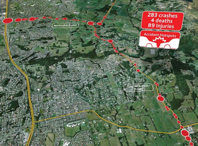
There are significant safety issues with this section with the map below showing the crashes that occurred over the 4 years to 2013, clearly something that needs to be addressed but the big problem with the proposal is it was a large pseudo-highway designed for speed and not a modern urban arterial.
The 2018 update to the Auckland Transport Alignment project, suggested the following as the course ahead.
It is clear that some improvements need to be made along the Mill Road corridor over the next decade, to improve the resilience of Auckland’s transport system and to support growth areas along the route. While further work needs to be done to identify where these improvements should be targeted, key priority areas for investment include:
- Improve intersections to address the most severe congestion
- Improve parts of the northern end to address the most severe safety issues
- Construct sections that pass directly through former Special Housing Areas at the time these areas grow
- Construct the new Drury South interchange
- Undertake route protection and land purchase of the southern section.
Auckland Transport has advised that these improvements will cost around $500 million.
This suggestion was reasonable, address the most urgent issues during the first decade of that plan and look at the rest of the corridor in future decades as needed.
Then in early 2020, the government surprisingly announced they would fund the entire 21km corridor for $1.35 billion and that Waka Kotahi would build it.

No one knows why the government decided to bring forward parts of the project so far forward given:
- there are so many other and more pressing areas that money could be spent – ATAP even included a list of the next priorities.
- the increased emissions outcome it would have given everything that’s known these days about the impact of building large roads.
- they’re also busy widening the existing SH1 corridor at the same time.
Then in June the government announced it would scale back the project after the project blew out to a massive $3.5 billion, or around $166 million per km – making it more expensive than even our most expensive motorways. Perhaps one reason for this is my understand the plans were to not upgrade the existing roads but build a massive new corridor right next to it that likely would have ended up something a bit like Wairere Dr in Hamilton.
While the full project has been scaled back, there will still be some changes.
Mill Road will become a smaller scale project, with a focus on addressing safety issues. It is expected to involve an upgrade of two lanes instead of four between Flat Bush and Alfriston tying in the existing urban Redoubt Road dynamic lanes. There will also be targeted safety improvements between Alfriston and Papakura.
The Argument for Mill Rd
Other than safety, the main argument for Mill Rd is about enabling more housing and supporting the housing that has already gone in near the corridor – though Deputy Mayor Bill Cashmore also tells anyone who will listen it’s also needed for trucks accessing the four quarries in the area.
There is certainly a lot of housing planned for the area in the future but part of the issue with Mill Rd is will further lock in auto-dependency as it does nothing to improve public transport in the area.
Part of the issue with Mill Rd is that while most people agree we need to address climate change, the corridor is already congested at times and that has impacts on people living in the area. As for why they’re driving, below a couple of comments in the Herald article from the weekend.
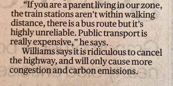
Local school principal Matt Williams

This from Papakura Local Board Chair Brent Catchpole
If public transport is inadequate, which it is, the solution isn’t to build a massive new highway, it’s to build better public transport.
Furthermore, as Jenny Cooper, QC of Lawyers for Climate Change and All Aboard Aotearoa said, “the reality is you cannot negotiate with climate change”. She also said “the challenge now is to decarbonise Mill Rd and make far greater use of rapid buses and upgraded rail services”.
Options for biking isn’t much better and where bike lanes exist they’re just paint for the brave, not suitable for families or those less confident with lots of cars and trucks around.
An alternative option
A big part of the solution then needs to be about how we make those buses and bike options better so the residents of the existing and future homes have valid alternatives.
The two key drivers to getting people to use public transport is frequency and reliability and on that count public transport in the area fails on both counts. With the exception of the 33 along Gt South Rd, buses in this part of South Auckland are infrequent and there’s little often priority meaning those buses are stuck in traffic.
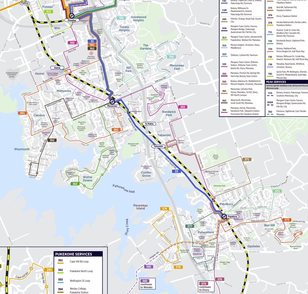
Panmure and stations on the Northern Busway have shown that Aucklanders aren’t allergic to transferring between services where it’s made easy. So a critical part of a solution is to do just that and to get people transferring more between trains and buses. For that to work we need both bus and train services to be more frequent and reliable.
Perhaps we could also look to straighten some of those routes out a bit. One thing that also strikes me about the area in and around Takanini is the grid that already exists with many ‘east-west’ streets that exist and which pass train stations, streets such as Browns Rd, Weymouth Rd, Mahia Rd and Airfield Rd. Interestingly the most notable one that is missing/broken is Mahia Rd to the other side of the motorway. However that has been proposed as part of the Supporting Growth work.
The bigger challenge is how to provide priority for all of this. If we follow the idea of using the east-west streets, some road reallocation and possibly even some limited and localised road widening might be needed. This would also need to provide for so much safer facilities for walking and cycling.
Those are some of the kinds of solutions the planners and engineers should be focused on instead of another parallel corridor.

 Processing...
A lot of those bus routes are just a complete mess, looking at that map.
I agree Kraut! This is outragous! #HECKAUCKLAND
+1
Agreed, very uneffective routes which happen to last at least 25 mins
“Most people agree we need to address climate change”! What evidence do you have for that statement? Since climate change is occurring very slowly, and seems to have 95% natural causes, attempts by humans to effect any change are extremely arrogant. Our “experts” do not even know whether it is warming or cooling!
Wow, are you still living in the 1980s? How are you on the internet?
It’s just a sad troll who doesn’t mind negative attention so long as it’s attention.
I don’t know why NZ has so much climate change denial. Even the UKs fairly right leaning government is doing vastly more than we are here.
Anecdotally I was watching some farming YouTube videos about a new battery or hydrogen tractor and almost every single comment was saying this looks a bit annoying but it has to be done. Can’t imagine that same conversation here. Can’t even people to buy less utes, let alone hydrogen tractors.
My point is, I really have no idea why NZ is so backwards in terms of climate change conversation.
I think we have more denial here because the effects were more immediately obvious elsewhere. We saw little weather change in the 90’s and early 2000’s but the UK already had. The changes here required a bit of effort to see, like shrinking glaciers or Lake Tasman which didn’t exist the first time I went to Mt Cook but is now several km long. A lot of denial is based on magical thinking, we have a lot of people like that.
It’s got to the point where people don’t even bother arguing with climate trolls like this dude, they just laugh and move on.
Yes, its like arguing with flat earthers. If they are truly that utterly stupid, they are probably impervious to education. And if they are saying they believe it for fun or personal gain, they are dishonest and/or predatory and don’t deserve your time.
Climate change deniers may be in the same camp, but it might also just be because they want to justify the suffering their actions are causing their great great grandchildren. So you can add selfish to their list of possible “qualities” too. There’s really no excuse at all.
Another issue are the level crossings on the rail line that need to go for safety and rail growth and efficiency. So clearly what the area urgently needs is a still big project that creates a series of east-west bus and active mode corridors connecting to new or upgraded interchange stations crossing over the rail line and the new housing areas.
It’s a potentially great project. The rail service with super modern electric trains is already there. The 3rd main is underway to add capacity. A direct north-south line intersected by frequent buses at good stations is exactly what both the long thin form of Auckland here is begging for, and is what already works brilliantly on the Shore, which is a similar shape. I know cos i use it everyday, and surely the people of south AKL deserve that standard too.
This ought to be obvious for our agencies, there’s already the bones in place; complete the job. A series of Puhinuis, or Panmures and straighten and speed up those feeder services across the already existing RT line.
Would be able to be done under $3b for sure and have lasting value, as well as leave budget for making the local roads safer, without overbuilding them. Unlike a parallel m’way which will just trap all people in cars forever and in way worse congestion over time.
Yes, this is a way better use of the money.
I would transform the area; give people options. I hope the local politicians can see this.
No good adding more stations without more tracks, it needs 4 lines from Papakura to Westfield at least. In fact they were needed as soon as the electric train service started but as per usual non road projects move at a glacial pace in NZ. That’s if they happen at all.
1. They are adding more track.
2. This is about improving existing stations so they interchange directly with buses as we elsewhere in the city. Maybe moving them somewhat in line with level crossing work.
3. Improve what ever can be improved; we are way past the perfect moment to improve things, it’s all way overdue.
We need our transport system just like Singapore and Tokyo where there network is just absolutely fantastic!
A few more pedestrian and cycle bridges over and under the motorway and railway could help. I can’t tell you exactly where as I am not that familiar with the area. Waka Kotahi cycleway along the motorway isn’t attracting to many punters yet but its early days. I feel like inventing a new transport mode let’s call it light trackless Trams to run down there to get people used to using it. Peddle assisted electric passenger cargo trikes.
Went past it a week ago, ona Sunday, and there would have been 25+ people using it as we went past.
The problem is the Southern Pathway, good as it is, doesn’t go anywhere, it’s marooned in a hostile sea of traffic at both ends. At the moment it’s really only good for local walkers and getting to Te Maihia rail station.
*Te Mahia
They never built the local links to connect it though; it’s just the superhighway bit with very limited ways to access it. At very least it needs a good safe direct way to cross the motorway at the northern end.
Please finish the job properly; it’s like a motorway with not enough on or off ramps.
I do see a fair number of families and teens walking on it on the weekends so it’s getting local use at least and it’s now in place so that gives imperative to connect to it and extend it to make it more useful for all trips. It certainly provides a connection that would have otherwise been an impossible barrier.
Royce, probably good to wait until we have numbers for the new path (I’ve heard they are looking very healthy).
Nah, the Southern Path is definitely missing an overbridge… we don’t need numbers to say that.
At the moment you have to double back some 4km along the Great South Road to get to Takanini. This could easily be solved by (a) putting in an overbridge here, though I’m not sure what its design would have to be like to connect with (b) the bizarrely unpaved inlet walk that already exists (the blue line in the first link; also, a picture of its unpavedness), but I will note the substantial curvature of the current bridge.
I expect this would created a 1.5km walk, which is less than half the distance of the current set up.
That being said, I’ve been there, what, four times now, at all times of the day and every time there’ve been plenty of people. It’s entirely useless for pretty much all of Papakura, but if you live in the new sprawl in Karaka or Conifer Grove, it’s practical. It’s a shame it deposits people into this nightmare at the Manurewa end, because aside from that I’d almost call it extremely useful for anyone that can get to it safely and conveniently who travels between Manurewa and Karaka.
Link to the images, in case my html failed: https://imgur.com/a/4ua46Rj
My argument for why the Southern Path very clearly needs an additional overbridge, regardless of the numbers (tl;dr, it turns a 4km double back along the Great South Rd into a pleasantly scenic 1.5km walk).
https://imgur.com/a/4ua46Rj
Wait until the Papakura-Drury three laning is completed. The Southern Path is being extended at the same time
Unfortunately, Drury is, like Papakura, also east of the motorway (though not as far over). It’ll probably work out for the new development (sprawl) at Auranga.
Maybe they’d put a bridge in around Slippery Creek…
The motorway and the Great South Road might be parallel but every established settlement is on the Great South Road’s alignment. As much as I like the Southern Path, it really seems like an alternative to making it safe to cycle along the Great South Road.
NZ Herald is reporting Waka Kotahi will only give Auckland $2.3billion of the $2.7billion needed for transport over the next 3 years leaving AT short $400million which will impact many road, safety and PT projects.
Given Goff’s statements on Thursday, I hope he realises he is now facing a “hard decision” (hard because it’ll get him out of his groove).
This is a chance to trim the emissions-creating projects and retain the safety and ones, to rebalance things and head the TERP towards the -64% emissions by 2030 required.
He might have to tell Government that Penlink’s money should be reallocated. And fight for that, for the future.
Sadly ,Phil’s mind is on sipping cocktails in Washington,another career politician,that gets elected ,does nothing,leaves others to fix his/her lack of direction,and rides on up the gravy train. Auckland needs better,but l guess money precludes inspiring people from standing, we will be left in another leader less vacuum,right when we need it.
AT are incapable ,and need political pressure, elected officials will be hunkering down ,to present themselves as electable for next term,meanwhile progress is mired in more reports,a tactical political move
Chlöe Swarbrick for mayor please
She’s also a career politician, we’ve had enough of them.
I’m of two minds about career politicians.
You need some set of skills to play the right political game in order to get what you want done done. It’s like a whole different job. If you put me up there (and assume for arguments sake that I will do what is “best”), I would get absolutely shredded, and not get done what I would want pushed through at all.
The politicians need to listen to some technocrats in each field they want to make rules / funding for, and go to war to get done what those technocrats think is right. Which is kind of what we do now.
Perhaps it would be better to have people in politics who were both, they developed skills in a hands on field, and then “retrained” later to become a politician. But they’re always going to have a disadvantage compared to someone who spent all their time only developing only the politics skills.
It also seems that the non-career politicians that do any good, tend to be the most opinionated, populist, impossible to have listen to reason, or think things through people out there.
But with the career politicians you can also end up with garbage too. People making decisions based on their experience which is totally out of line with what they are making the decisions about.
The only think worse than a career politician is some ‘business leader’ or restauranteur that knows nothing about being a politician trying to do politics.
Isn’t that just the same as other Councils have faced this year with WK reducing previously-signalled contributions?
During rush hours, and also a fair bit of the weekend this whole area is approaching a grid locked mess. If there were buses running east-west or pretty much anywhere, they’d also be held up.
If I was living in the new sprawl area east of Takanini/Papakura, and working in Wiri or East Tamaki, I don’t think I’d want to face trying to get there in winter by PT, probably at least two transfers and a lot of walking required. And driving is obviously no pleasure.
Really, I can’t see a way of fixing it. The sprawl should just be stopped and 30-50 story high apartment buildings built on the rail corridor.
The buses out there are completely uncompetitive with the private car. The Southern line has been very unrealiable for the past year and is still running slow.
Once the CRL opens, there will be a express line for the southern, but will go through the eastern line too.
People thinking we can’t fix these problems is probably the worst legacy of our car dependent planning. Of course we can.
Fix the bus frequency and priority then. And connections to stations, as I said above. Ticks every box: climate, equity, housing, safety…
Fixing bus priority is easy to say but politically extremely difficult to do.
Especially when AT are involved
Why does the 365 run that route south of Manurewa? It should just go straight up Porchester, turn left on Alfriston and head to the station and onwards.
Every deviation towards the rail line looks walking distance from Porchester. In fact, that part of the route looks like its intended to get people to the rail station and alot of the catchment looks within walking distance of some stations.
Better walking cycling access to stations and a mode direct bus route to Manurewa looks an easy win.
Possibly not as walkable as it first appears:
https://app.traveltime.com/search/0-lng=174.90615&0-tt=15&0-color=%23f7941d&0-mode=ferry&0-title=Te%20Mahia%2C%20Ferguson%20Street%2C%20Manurewa%2C%20Auckland%2C%202105%2C%20New%20Zealand&0-lat=-37.03125&1-lng=174.91106&1-tt=10&1-color=%23d60064&1-mode=ferry&1-title=99%2C%20Shifnal%20Drive%2C%20Randwick%20Park%2C%20Manurewa%2C%20Auckland%2C%202105%2C%20New%20Zealand&1-lat=-37.02737&2-lng=174.91105&2-tt=15&2-mode=walking&2-title=99%2C%20Shifnal%20Drive%2C%20Randwick%20Park%2C%20Manurewa%2C%20Auckland%2C%202105%2C%20New%20Zealand&2-lat=-37.02737
And one doesn’t walk far in Manurewa East.
How much would it cost to extend the Eastern Line from Manukau down Mill Rd? Surely more expensive but also probably better value for money. I mean, if they were suggesting building a pseudo-motorway right next to it, then this isn’t a crazy idea and would enable better growth.
Interesting idea. No doubt hugely expensive but probably good value, as you say.
I’d say start with dedicated buslanes, same on some key east-west routes, and work up to rail if demand follows.
Definitely agree, though if it’s going to be a growth area, might be a good idea to get the land while it’s ‘cheap’.
Billions upon billions.
The Eastern Line would have to crawl up the substantial slope of Redoubt Road and then take a right angle into Mill Road, which undulates until it becomes flat.
Alternatively, tunnels.
The solution is simple… whack down some buslanes on the shoulders of Mill Road and Murphys Road, take away the median on the intervening stretch of Redoubt Road to accommodate bus lanes, and run the 371 to Botany.
Shift the 35 over to Te Irirangi Drive or preserve its current alignment, but without the dogleg to Flat Bush because the 371 now runs through there. (Bus lanes will probably be required on Te Irirangi and Chapel.)
Two busses fixed. The only problem is that parts of Mill, Redoubt and Murphys Rd don’t have good shoulders for easy conversion to bus lanes and they do get congested during peak so bus lanes are needed.
Why, Whirsler? As you say, there aren’t easy shoulders there for this anyway… so it would need widening. Why not connect to the RTN with EW routes instead?
EW?
East west?
I like the idea of extending 371 up, but instead of to Botany, terminate it at Manukau. If people want to go to Botany, they can xfer to A2B line.
The benefit here is that as the area gets built up, 371 would become frequent, which will probably never happen for EW routes.
Why would you create another Papakura/Manukau line? It’s pointless and doesn’t fix the Flat Bush issue:
https://www.greaterauckland.org.nz/2020/09/16/airport-to-botany-and-the-problem-of-flat-bush/
I seriously doubt it’s possible to make Papakura/East Auckland viable by PT without either making it the only option or going along Mill Road. As I’ve written elsewhere:
Right now, South-East journeys might just be the most brutal ones you can undertake by public transport on a time/distance basis. Take that Papakura High/Botany Downs Secondary College trip, by car it’s about 21 minutes without congestion (40 minutes during peak) to travel 17.5km by road but to allow a PT comparison, we’ll use the 14.67km straight line. By my measure of convenience, that’s a score of 1.43 minutes/km (2.73 during peak). By PT it’s 4.70 minutes/kilometre. Note that Papakura High/Rangitoto College takes nearly 50 minutes longer at 1hr57min, but the rating is “just” 2.86. As I said, brutal.
A2B is currently a bus scheme intending on delivering a 35-40 minute end to end journey, so subtract off 10-12 minutes for the Airport to Puhinui leg and that gives us 23-30 minutes for the eastern leg. I’m not sure what the post-CRL Papakura/Puhinui journey time is meant to be so let’s take that as being 13-18 minutes (13 minutes is an 18% improvement on the present fast timetabled time, 18 is the long time). Adding those together and we have 36-48 minutes, which, without any allowances for transfer times, gives us raw convenience scores of 2.45-3.28. If we assume a 30 second to 2 minute transfer and ten minutes walking, we thus end up with a final score of 3.12-4.09. Both of those are worse than the current Rangitoto time (4.7) but are a substantial improvement on the current convenience. Perhaps more concerningly, the upper estimate is only a nine minute saving on the current fastest journey of 1hr9min (according to Google Maps). Mind you, the fastest version would be a 22.5 minute saving.
….
Note that the 371 is intended to serve people who’d have to catch the 371, 365 or 372 to Papakura (or possibly Takanini or Manukau) which would mean the convenience scores would increase further (which is bad)… Papakura High is a short walk past Massey Park and across the train tracks from the train station.
Because neither of route is meant to connect Papakura & Manukau to one another, they are meant to serve the destinations in between and connect those destinations with the major transfer points on the ends and in between, where they exist.
I’d have to spend more time reviewing O-D data than I’m willing to do in my free time on break, but on the surface I’d expect way more people would be wanting to get to Manukau and the train than to Botany. If 371 went to Botany, the only alternative would be to take some infrequent connector (note, I’m assuming the 371 would become frequent with developments along Mill Rd), which is unlikely to ever become frequent due to its short length.
A lot of that A2B travel time is spent wiggling around Manukau, so that would be skipped for anyone transferring at Redoubt Rd. I see what you’re saying though about that making any journeys from the south to E Auckland cumbersome. Are you suggesting duplicating the A2B or running on Murphys? The former seems like a waste of service (and doesn’t address Fbush) while the latter is not very useful for most people on Mill Rd because they won’t have anywhere to connect to transfer into Manukau and even if they did, it’s now a 3-leg journey if they’re getting on the train. Another alternative would be to run 371 to Manukau, with another frequent service from Manukau to Botany via Murphys. This would pump a lot of buses down Manukau Station Rd and probably be a bit redundant for that stretch but may be worth it, again, depending on where people actually want to go.
A2B isn’t going to go anywhere near Redoubt Rd.
https://i1.wp.com/www.greaterauckland.org.nz/wp-content/uploads/2019/11/2019-11-Airport-to-Botany-Map.jpg?ssl=1
SH1 is labelled… Redoubt Rd is the horizontal line intersecting it about where the Manukau label is.
“O-D data”
I don’t know what this is.
“on the surface I’d expect way more people would be wanting to get to Manukau and the train than to Botany.”
I doubt it. Firstly, the problem with the 371 is that basically none of its route is exclusively served by the 371. If you extended it to Manukau, that wouldn’t change because (a) one of the duplicating busses is the 365 that already does that with substantially greater frequency, and (b) you’d be travelling along what is, even now, still mostly farmland… there isn’t, functionally, anywhere in between. (This makes the 371 as currently designed pointless.) Secondly, for anyone able to get to Papakura station, they already have three alternatives to get to Manukau (the 33, the 365 and a transfer at Puhinui) but there is no direct route to Botany. And, thirdly, as I have pointed out, interchanging will never be quick.
“the latter is not very useful for most people on Mill Rd ”
Redoubt Rd gets congested, yes, but so does Murphys Rd… the congestion on Mill Road is the result of both streams of traffic.
People going from Papakura to Manukau are inhibited by the lack of bus lanes on the Great South Rd (making the 33 a slog) and the low frequency of trains (making transferring a slog). Fixing those problems solves Redoubt Road. It is possible to have convenient travel to Manukau. The very first 33 of the day does it in 22 minutes, which is a convenience score of 2.22. The 17:10 33 from Manukau takes an hour to get to Papakura, scoring 6.01 (which is worse than that fast trip to Botany… hmm). Along most of that route, there’s space for bus lanes.
Flat Bush might not be in a good alignment for busses from Manukau, but you have to actively avoid it if you come from Mill Road. The 371 has a problem where it does nothing particularly useful for anyone, but runs along Mill (well, Cosgrave) Road. People want to get from Papakura to East Auckland so much they create congestion. I don’t understand why people don’t see the obvious solution.
(Well, yes, the awkward shoulders but to my lay eye, they’re not that bad: https://imgur.com/a/kfXGHvH)
“A2B isn’t going to go anywhere near Redoubt Rd.”
Right, for some reason I was thinking Redoubt intersected TI, but that’s Hollyford. That makes that whole connection a bit more challenging.
O-D = origin-destination data, which is based on travel surveys of where people actually travel. When projecting into the future we can only rely on models.
““on the surface I’d expect way more people would be wanting to get to Manukau and the train than to Botany.”
I doubt it.”
Well, I doubt your doubt. There are just way more things accessible from Manukau (train network, Airport, Manukau itself) than just Botany. But a good plan shouldn’t be based on our reckons so let’s not discuss this any further.
“(a) one of the duplicating busses is the 365 that already does that with substantially greater frequency,”
365 is 1.6km from Mill Rd, not a viable alternative for anyone on Mill Rd.
“(b) you’d be travelling along what is, even now, still mostly farmland”
I’m talking about planning for the future when Mill Rd is developed, not what we have now, so maybe we’re having different conversations here. You’re right, at the moment, 371 to Botany via Mill, Murphys would be a great way to get from Papakura to (some of) E Auckland. But it would be a waste of money as it’s passing through empty farmland for most of the time so it would essentially be a peak express service, which is exactly what the New Network was designed to get rid of.
“People going from Papakura to Manukau are inhibited by the lack of bus lanes on the Great South Rd (making the 33 a slog)”
Agree, reallocating car lanes to bus lanes the entire length should be done no matter what.
“People want to get from Papakura to East Auckland so much they create congestion. I don’t understand why people don’t see the obvious solution.”
Be careful stating things in complex systems as ‘obvious’ or you’ll start to sound like a right winger saying it’s ‘common sense’ to build another motorway 🙂
People create congestion everywhere. Just because people congest the road a bus would run along doesn’t mean a bus would serve their needs. Again, the data could help answer that question.
I don’t necessarily think a bus service from Papakura to Botany along Mill Rd, Murphys would be a bad idea in the future but it would still leave the gap of serving the future population along Mill Rd who, in my professional opinion, would be more likely to need to connect to all the things they can connect to at Manukau than at Botany. Maybe if that area is built as high-density, mixed use, then there would be enough demand to provide two overlapping frequent services, one going to Botany from Papakura, another going to Manukau from a new mixed use centre at, say Alfriston Rd or Airfield. But then, you’re risking another Flatbush, which is why an extension of the Eastern Line could be good, if it’s combined with creating a string of high-density mixed use nodes at the train stations. These could even support frequent EW service to connect between the train lines. It could be funded by value capture financing. Again, I’m just kind of flinging things at the paper here to see what sticks so I appreciate your input as you’ve obviously spent a lot of time thinking about it.
I don’t think funky shoulders should be considered too big a problem, at least in the medium-long term.
We cancelled the mill road project when the government announce cycle bridge.
Now the cycle bridge is cancelled, but the mill road project is dead.
So now we have neither.
Today news talks about 400m deficit.
It is a matter of time another project get cancelled. (hint: botany busway)
That project is being delayed by 2 years, announced a little while ago
The issue is more than Mill Rd.
If we had full transport pricing
a) congestion tolls
b) dynamic parking pricing & no free or time restricted parking
c) air pollution tax
d) carbon tax (we have ETS)
e) full payment of crash costs
f) removal of ratepayer subsidy for roading
&
i) a fully flexible and elastic land use law
ii) a combined land use / transport authority
then a series of TODs + BRT(or other mass transit) could result along Mill Rd.
Instead we will end up with yet more mainly car dependent suburbia.
Most of the bus services either start or finish at Manukau, Manurewa or Papakura and are probably designed to serve these town centres. Bus route 33 also serves the almost continual retail south of Te Mahia station. A change to East West bus routes suits travel to the city but turns a trip to the local shops into a two stage journey. Also it might create a lot of empty bus movements. But I could envisage bus stops at station with electric buses connected to their charges waiting for passengers to disembark from their train ready to whisk them off to their destination. So we would have a bus system where layovers would be at the centre of the route rather than the end.
The next thing is do we require any passengers from the South to Botany to transit through Manukau or Puhinui and Manukau. This seems a bit of an excuse to take a car. But it would be hopeless sending a bus along a congested Mill road anyway whether it goes to Manukau or not. So maybe Matt.L is suggesting we do.
My other plan for a motorway bus from Puhinui to Westgate via Onehunga fits into this its just a pity I can’t think how to connect it easily to the Western line along its way.
How about making the the corridor from RamaRama to Ormiston Road, or to Ti Rakau Drive. Would make more sense. This would also divert most of the traffic off the SH1.
Not sure what you mean exactly. Are you talking about rail or bus – or just another road project?