Currently, Local Boards in Auckland are being asked to consider two different options when it comes to PC120. In our view, Option B is ideal as it focuses upzoning around existing infrastructure and strong transport links, within the central isthmus. (By contrast, Option A does only the bare legal minimum.)
That means the endorsement of Option B by the two most centrally located local boards, Waitematā and Albert-Eden, will be extremely important.
This post is a copy of a document we’ve sent to those two local boards. We’re sharing it here as we felt it may be useful for anyone who is interested in emailing their local representatives about the housing choices ahead..
Summary of feedback
Greater Auckland encourages the local board to support Option B, with any amendments the board sees as necessary due to local context.
In comparison to Option A, Option B is the best choice as it will do more to improve affordability, reduce Auckland’s transport emissions, create a more walkable and liveable city, make the most out of our existing and new infrastructure, and deliver the greatest economical benefits.
The two options
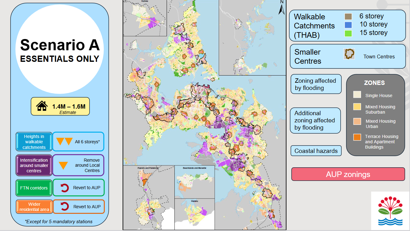
Option A would deliver the absolute bare legal minimum. Based on Auckland Council’s own analysis, of the scenarios originally proposed, it would result in the least amount of additional housing supply, and therefore have minimal impact on housing affordability (at best a 1-2% reduction in future house prices, compared to status quo settings).
Crucially, Option A wastes enormous potential for smart leveraging of existing infrastructure, because it fails to upzone in the areas around and along frequent transport links, and around local centres. It will only upzone beyond 6-storeys around a handful of inner-city rail stations as required under the law change, missing the wider benefits of the CRL investment.
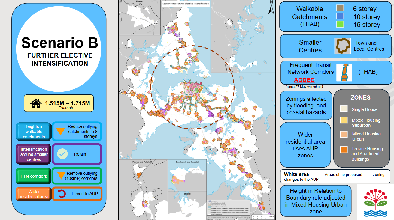
Option B, by comparison, will concentrate upzoning where it’s most beneficial: in the central isthmus, focusing on greater density around and along the frequent transport network, and adding more homes within walkable distance of local hubs and town centres.
In contrast to Option A, which only does what is legally required, Option B will upzone to at least 10 stories around the rail stations within 10km of the City Centre set to benefit the most from CRL. This will lead to more affordable homes, closer to where people most want to live.
The Evidence is Clear: Option B is Better
Historically, Auckland’s central isthmus developed along the tram lines. This meant that neighbourhoods in our city’s more central areas were originally conceived and built as mixed-use local centres, where people could easily get to and from public transport and daily amenities – shops, work, play and more – all before the widespread adoption of the car.
Today, the central isthmus still has the best public transport coverage in Auckland, and also retains easy local access to abundant amenities. This makes the central isthmus ideal for “density done well”: providing more homes closer to where people want to live.
The evidence supports this, as we can see in three pieces of research.
Car dependency
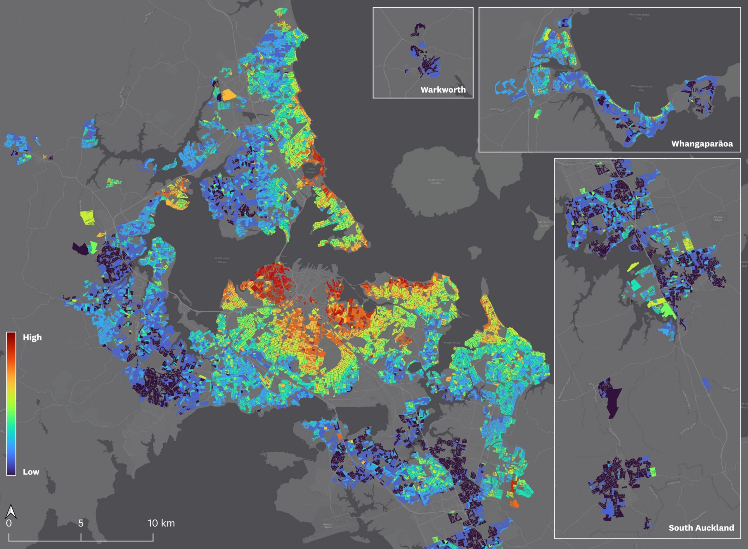
Firstly, Dr Tim Welch, Senior Lecturer in Architecture and Planning at the University of Auckland, has created the Auckland Transport Access Atlas to show the accessibility of different areas in Auckland by different transport modes.
Especially relevant to local boards – and very good information you can help communicate to the public more widely – is the map showing car dependency. Car dependency is a measure of how obliged people are to rely on driving in order to access basic everyday needs such as jobs, shops and education.
The red-shaded areas on the map below have high car dependency. Whereas, blue shading shows the areas where people can equally and easily access everyday needs by using public transport, walking, or cycling.
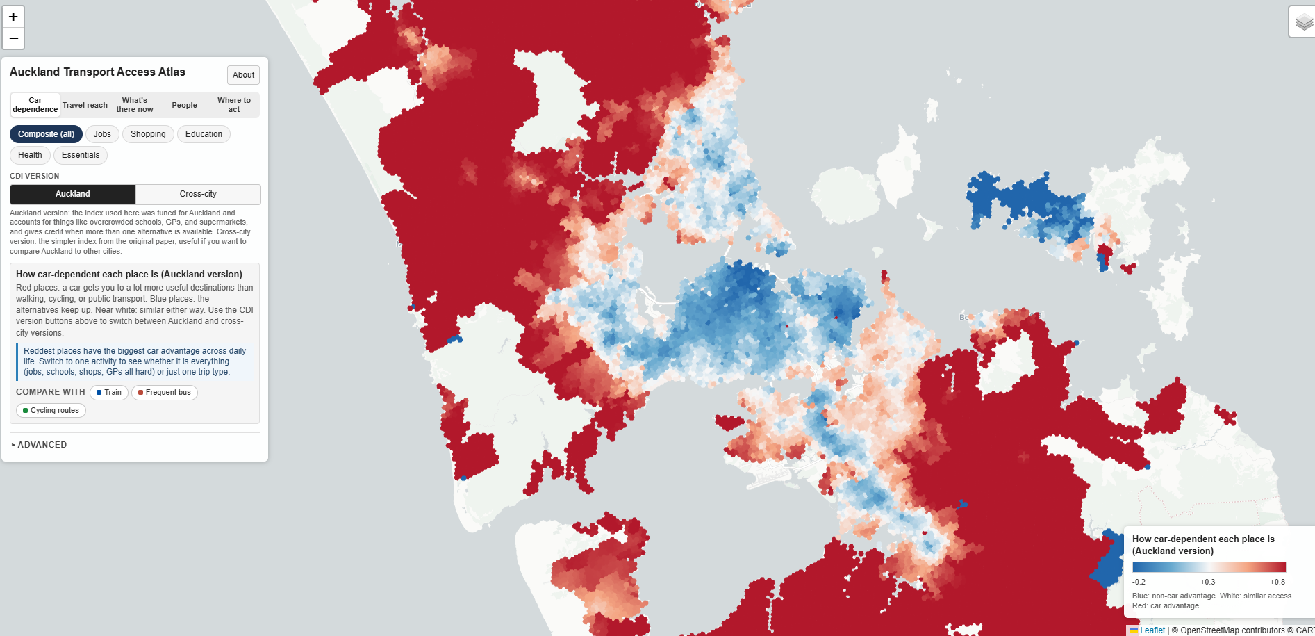
Car dependency across Auckland, as shown on a map developed by Dr Tim Welch. Source.
This is important to this conversation, as areas where it’s easy to get around by walking, cycling, and public transport are far more suited to more housing through upzoning that enables apartments and townhouses, as seen in other successful quality compact cities. As you can see, the central isthmus, and areas around our train lines, are the most blue.
If you compare Auckland Council’s Option B with Dr Tim Welch’s car dependency map, you see that Option B’s areas of upzoning (which make the most of the already-existing Rapid and Frequent Public Transport networks) overlap tidily with the areas in blue.
Water infrastructure capacity
Secondly, Watercare has updated its maps showing where the water network has capacity for more housing development, and where it doesn’t. Again, you can see at a glance that the central isthmus (and a few outlying areas) is where the existing pipes can actually handle more housing, with the lowest need for investment in new and improved water infrastructure to add more homes.
While acknowledging there can be capacity limitations at the hyperlocal level, these overview maps are another powerful resource that local boards can and should share with the public. The question of overloaded pipes and waterways often comes up in housing debates, and for top quality conversations, we all need to be across the latest and best evidence.
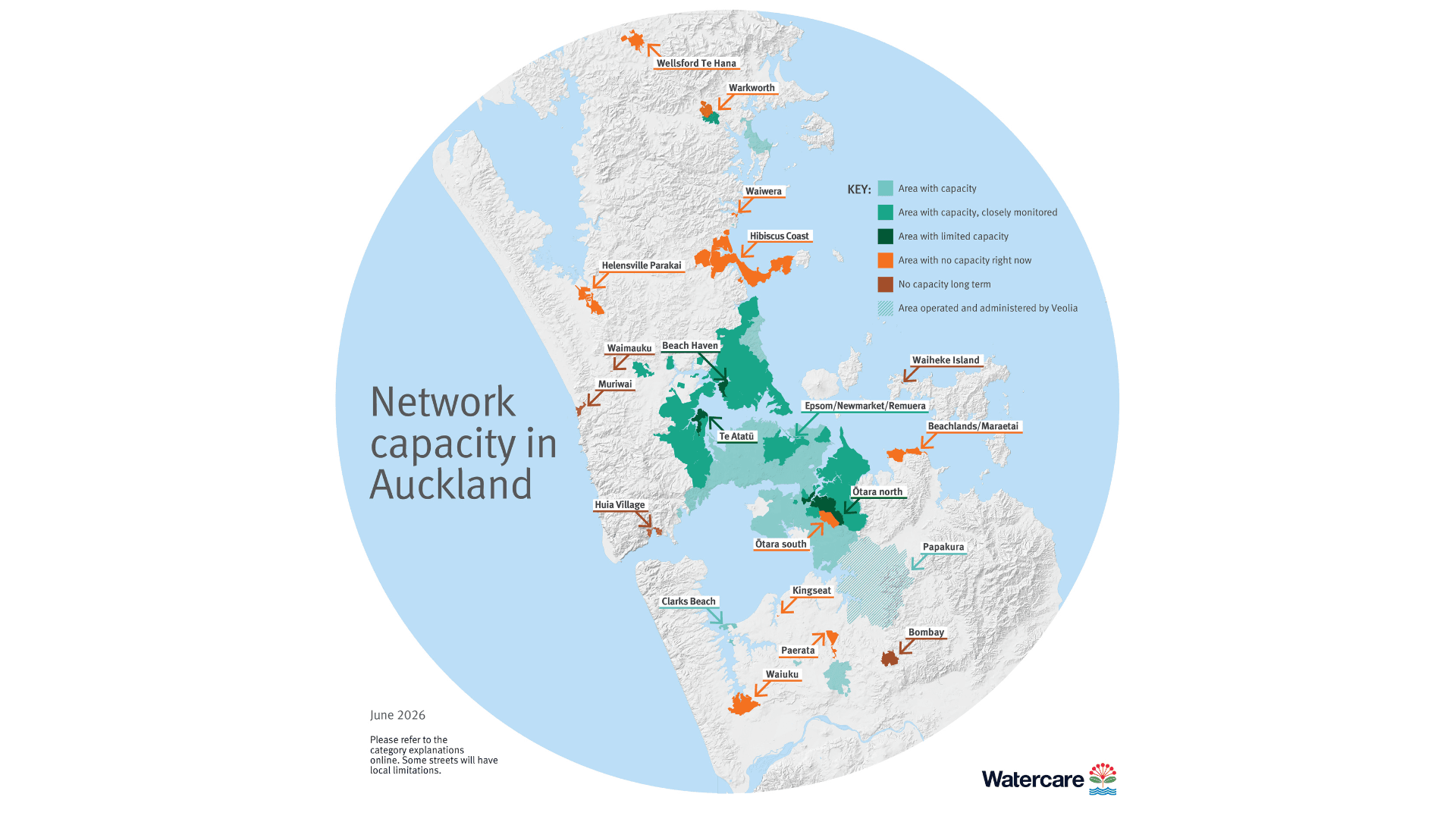
Water network capacity in Auckland. Source: Watercare.
Affordability and other economic benefits
Finally, in 2025, Auckland Council, through its Chief Economist Gary Blick, looked at land values. They found that areas closer to the city centre had substantially higher demand and thus higher land prices – meaning, in simple terms, more people want to live there.
Again, we would ask the local boards to share this information in all of your public discussions of the options available to you, so that everyone can see you are committed to making evidence-based decisions in the public interest.
Estimated residential land values per square metre. Source: Auckland Council Chief Economist Unit
Land value is an important factor in housing development, as the areas with higher land prices are much better suited to higher density housing. Essentially, upzoning means you can create more homes on a given piece of land – and, as a consequence, these homes will be cheaper per unit to construct and thus ideally more affordable to homebuyers.
Further supporting this point, Council’s economic work in December 2025 on the benefits of PC120 (which lives on in new form as Council’s “Option D”) found that concentrating more housing in central locations would also have the effect of reducing development pressure (and thus pressure on infrastructure) in peripheral areas further from amenities, e.g. Kumeu.
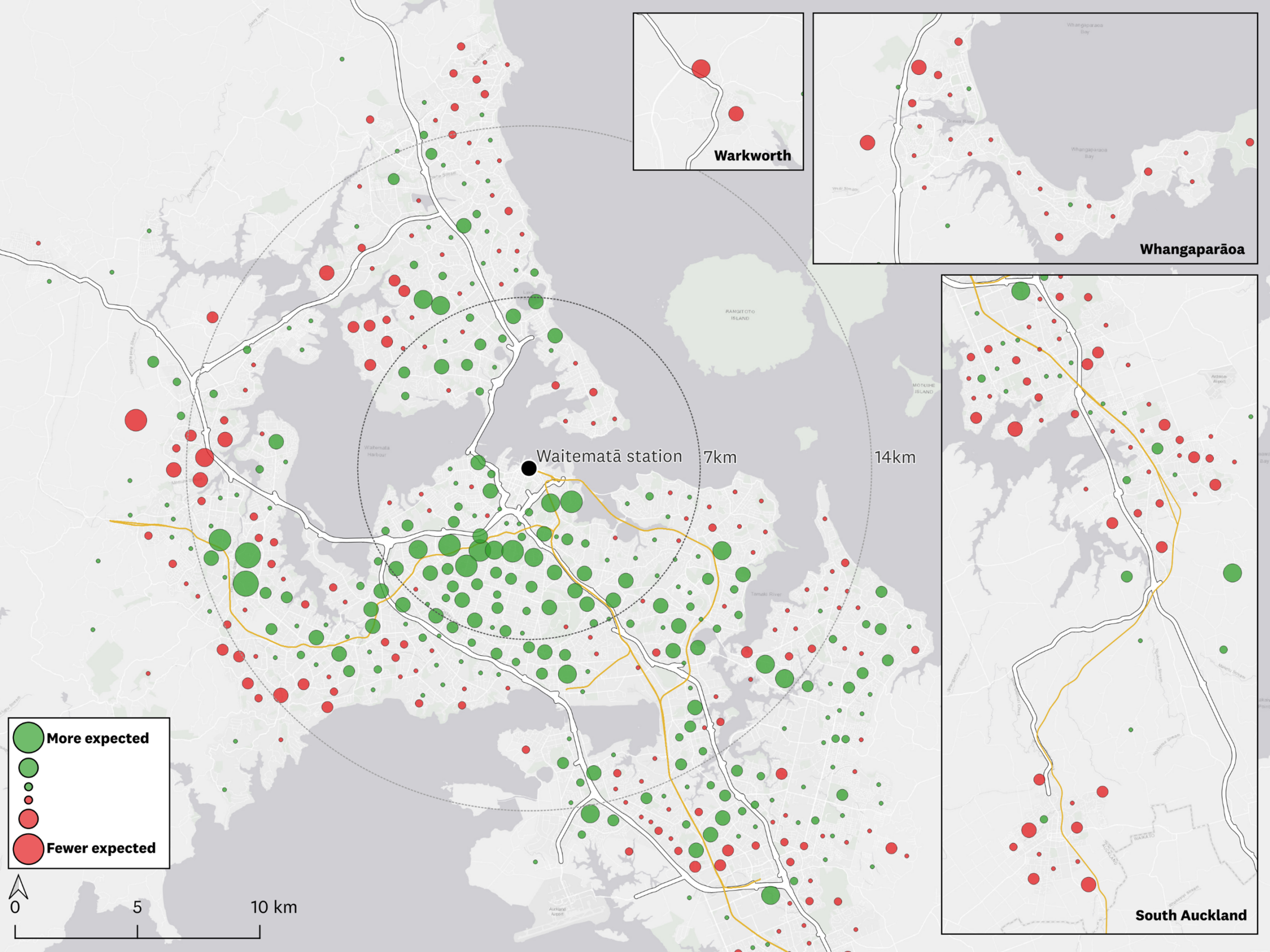
Forecast change in new homes over 10 years under Plan Change 120 (which is now Option D) relative to Plan Change 78. Source: Auckland Council Chief Economist Unit.
Option B, currently with you for consideration, is a much more targeted version of the original PC120. The outcome will be that we see more houses closer to where people want to live.
Moreover, the City Centre itself remains – and will always be – Auckland’s major hub of amenities, employment, education, as well as a place that Aucklanders want to live in or close to, work and study in, and visit for shopping and fun. So enabling more intensification and homes in places that are well connected to the City Centre is simply good economics.
Five key benefits of Option B
Firstly, it reduces Auckland’s climate impact. Transport emissions make up the largest single source of emissions in Auckland. A more compact city where more people are able to get around by walking, cycling, and public transport, rather than driving, will reduce those emissions. It will also reduce the accompanying pollution of our air (which has health and life expectancy impacts around ten times higher than the road toll) and water.
Focusing development around existing public transport nodes is one of the most powerful ways you and Auckland Council can contribute to tackling climate change, as well as helping to keep our waterways, harbour, and beaches clean and healthy for all.
Secondly, more homes will help address the housing affordability crisis. Sufficient supply is a fundamental necessity for housing affordability. Council’s original economic analysis found Option B strongly outweighs Option A for affordability, with a 1.7 benefit cost ratio (now likely much higher, due to improvements since the earlier version was presented) compared to Option A at 0.7.
Thirdly, housing density in walkable neighbourhoods helps promote economic prosperity as people have better and more frequent access to shops and leisure activities. This proximity, to people and to other business and amenities, makes it more feasible to establish more businesses and social infrastructure. Studies show that better cycling infrastructure and public transport connections are extremely beneficial to the vibrancy of businesses, as well as being essential for all-ages travel. In other words, density should be accompanied by accessible street environments.
Fourthly, building housing near existing infrastructure means less expensive expansion across greenfields. The average greenfield house development requires a subsidy of $150,000 per house. By concentrating development in existing urban areas, you can spread the rates burden across more households, while enabling more efficient use of our existing infrastructure, and also reducing the need for new public investment in expanding water, electricity, and other key infrastructure out into the rural greenbelt.
Finally, intensification around town centres and local hubs diversifies housing options, providing a wider range of housing options for all stages of life. It creates opportunities for older people to downsize while remaining in their own communities, thus freeing up equity, and releasing homes for younger people and families – allowing them as well the ability to afford to stay and live in our city and communities. It also means more versatile options for first-time home-buyers of any age, beyond single-family houses on large sections.
This is a virtuous circle, quite literally bringing different generations of Aucklanders back together and revitalising communities. The alternative, as current demographic trends show, is younger families will continue to be pushed to the outer suburbs, unable to afford homes in inner communities, a less ideal outcome for everyone.
Option B will contribute to all of these benefits if adopted. Whereas Option A actively backs away from all of this potential, and represents the do minimum approach to PC120.
As always, of course there will be local nuances to take into consideration, and we look forward to your work and supporting evidence. With two options in front of you for feedback and endorsement, only Option B puts housing where it makes the most sense.
A local example
Auckland has an exemplary and ongoing case of “density done well” in Point Chevalier. The suburb has seen significant recent growth in apartments and townhouses, some public and some private. At the same time, a wholesale rebuild of Point Chevalier and Meola Roads – and, crucially, the stormwater infrastructure underneath – has created a walkable and bikeable suburb.
As well as frequent public transport, Point Chevalier is now well-connected for car-free travel (locally, and beyond) with safe all-ages cycleways, new pedestrian crossings at key bus stops, shops and parks. There are new trees, rain gardens and other improvements, which with the stormwater upgrades will help reduce pollution of local waterways and regional-attraction green spaces, with hopes the popular beach (re-sanded by Council in 2008) will also be more swimmable, more often. A win-win virtuous circle!
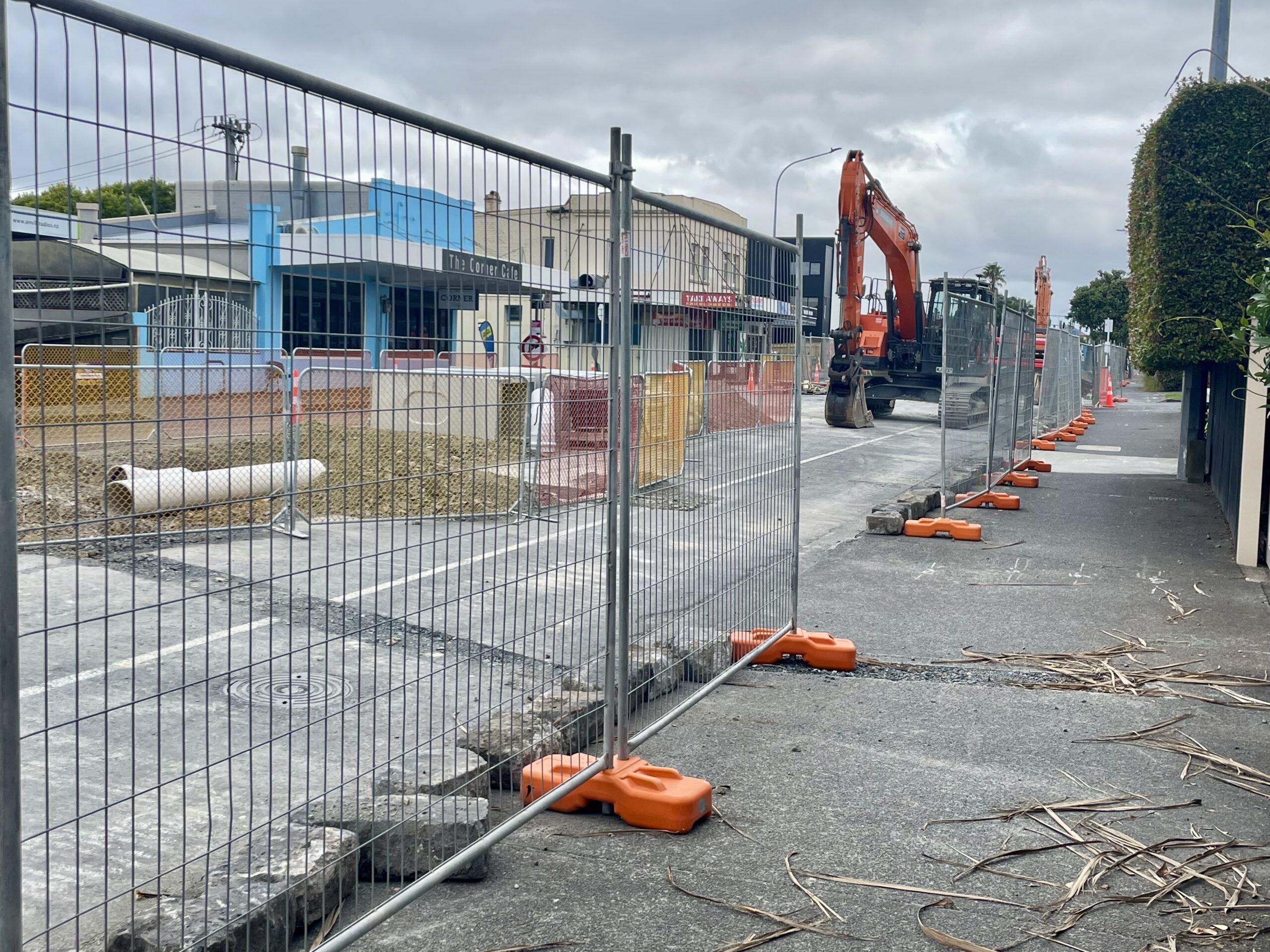
Pt Chevalier Road works, 2024
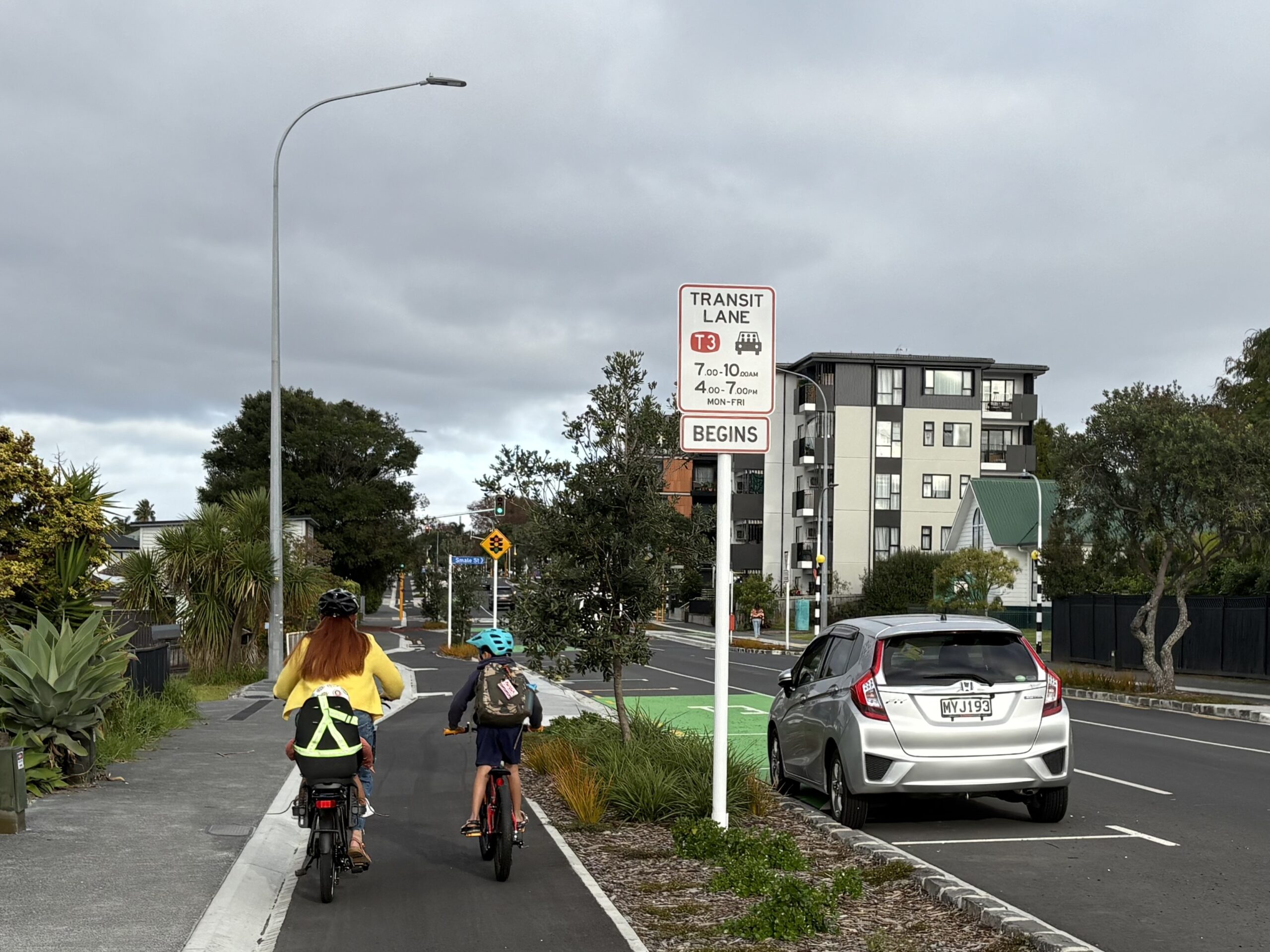
The results, 2025
While there are always further improvements – including expanding the infrastructure improvements and safe cycling connections north of Meola Road, towards the primary school, the beach and Coyle Park, the suburb is now a great exemplar – a “model village” – that the local board can proudly point to, which can and should be used to guide improvements wherever intensification is occurring.
We would also note, by way of example, the similarly thoughtful and beneficial integration of new housing with improvements to streets and greenspaces in the Kāinga Ora-initiated Ōwairaka development and others within the central isthmus.
Additional points
We think it’s important to note a few more things:
- Option B still leaves large swathes of single house zones and “Special Character Areas”, including in central locations and walkable catchments, while ensuring the best locations for intensification are upzoned.
- In our view, protection of heritage is better achieved through Historic Heritage areas, rather than Special Character Areas
- Unlike the Medium Density Residential Standards (MDRS), which applied upzoning universally across the city as a whole, Option B concentrates development where it makes most sense to do so.
- Flooding hazards are often better addressed through targeted qualifying matters and other rules, rather than via broad downzoning
- Design is important, and well-designed new housing is best addressed through design and quality standards, rather than zoning rules.
- Auckland Transport has robust tools to identify where the best public transport networks in Auckland exist. We therefore know where it makes sense to intensify around transport, so let’s choose planning rules that reflect this knowledge.
Suggested amendments
We encourage the local board to support some amendments to Option B – to ensure it truly delivers the maximum potential for good quality, affordable housing options where people most want to live:
- Firstly, we recommend exploring an amendment in which the 6-storey limit is instead replaced with an 8-storey limit. We understand that it is often more economical for developers to build 8-storey developments rather than 6-storey, so providing this flexibility could lead to more housing. We encourage you to confirm this understanding with experts in the field.
- Secondly, where “Special Character Areas” remain, we would encourage the board to support upzoning to the level of what would otherwise be in place. For example, if a walkable catchment due to proximity of frequent transport stops would otherwise lead to upzoning for 10-15 stories, then the underlying zone should reflect that.
We also note that, while the evidence in our document speaks to the high-level overview, there will of course be specific local contexts that may require changes. We would encourage the board to take this into consideration and seek out and apply local knowledge, while also keeping the bigger picture in mind.
Conclusion
We encourage the Local Board to support Option B along with any local changes the board deems important, and to advocate for increasing the height limit from 6 to 8 storeys.
Greater Auckland’s work is made possible by generous donations from our readers and fans. We’re now a registered charity, so your donations are tax-deductible. If you’d like to support our work you can join our circle of supporters here.

 Processing...
Thanks, Connor. Great work.
Being the cynic I am, it is a worry that a lot of your good points could be read as negatives by the leafy NIMBYs. House values, up not down thanks! Cycleways, as long as I can park my car in them.
Let’s all hope that the greater good overcomes narrow self interest.
Pt Chev might have been done well, but to hear Pt Chev residents talk, the Carrington development is quickly becoming a planning-blight disaster
BTW, CRL is officially handed over to KiwiRail today, according to popular report
Hold on – the price of land is higher because more people want to live there? Maybe the price of land is higher because there is less of it towards the centre. If you look at circles from the centre the area increase at the square of the radius. If you go five times further out you have 25 times the area. If you really want to go down the revealed preference route then get rid of the land use rules and Rural Urban Boundary and have a look at where people actually choose to live.