NOTE: on Friday 27 February we received an update on this project from Auckland Transport – you can scroll to the bottom of the post to read it.
Picture this.
You’re a Council, keen for more housing in a compact, liveable city. A chunk of former horse-racing land is up for grabs, on a major route across the heart of the isthmus, close to a park, schools, hospital, frequent buses and a train station. It ticks all the boxes.
Obviously, you zone it for shops and apartments, and invite developers to go for it.
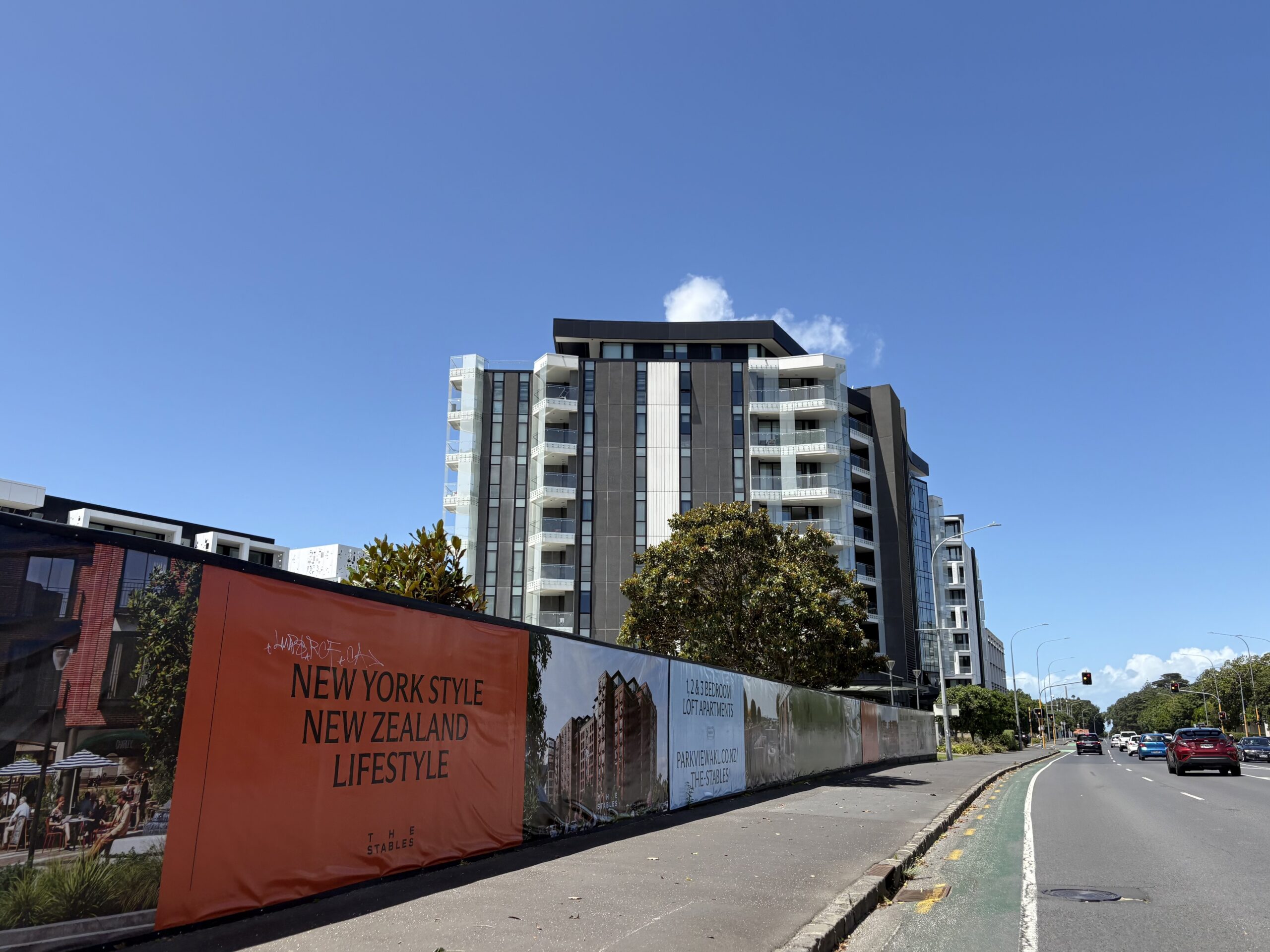
Work in progress: new apartments with ground level shops, taking shape at Alexandra Park on Green Lane West alongside the city’s most miserly painted bike lane.
You’re a developer, and you know what sells people on apartments: location, location, location! Plus layout, views, balconies, storage, etc. And to meet the market – and secure consent – you know you also need an appealing transport plan for the hundreds of people who’ll be moving in.
Obviously, you lean in: shared car fleet! Bike parking! A bike workshop, even! Consent unlocked!
You’re a Local Board, and you’ve been calling for safe cycling along this major route for a decade. How about now? More intense housing, more people riding bikes… also, it’s a climate emergency.
Obviously, you expect your transport agency to pounce on this opportunity.
You’re a transport agency. Your mission – should you choose to accept it – is to move more people more efficiently and safely. In this case, along Green Lane West, the four-lane road that runs past the front gate of the new development.
From a transport perspective: it’s a major bus route, leads to a nearby train station, and is a strategic regional route on your cycle network. Incredibly, though, it has no bus lanes, the city’s measliest painted bike lanes, and stop-start footpaths with dangerous (or no) crossings at key access points.
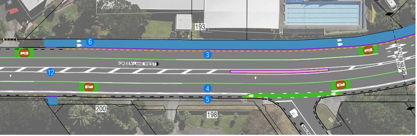
Obviously, you create a design with transit lanes, better footpaths, and a protected cycleway for people on bikes. You extend it west to St Andrews Rd to maximise the benefits for everyone already using this route, plus the hundreds of new residents. Like so:
AT’s 2023 design for Green Lane West, featuring a bi-directional cycleway, obtained via LGOIMA
And then you take that design out for public consultation, so you can get on with building it.
Right?
…right?
Wrong. Just before Christmas, Auckland Transport instead went to consultation with a different design for “Better Journeys on Green Lane West“. It has no protection for people on bikes – just a combo of painted lanes and shared paths, which pit bikes, buses and pedestrians against each other.
If that design goes ahead, by the time it’s constructed the transport governance changes will have kicked in, meaning the Mayor and Councillors will “own” Green Lane West, and any fallout thereof.
Yikes.
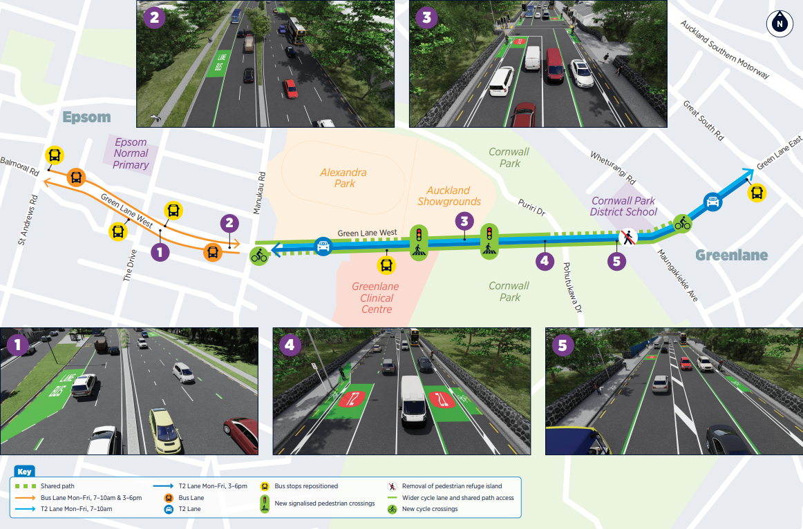
AT’s December 2025 design for consultation: painted bike lanes, shared paths, and nothing for safety to the west of Manukau Road.
The good news is that Auckland Council, Albert-Eden Local Board, and the developers are on the same page here. There’s a clear consensus on smartly integrating new housing with great transport choices, for a more resilient and healthy city and just a nicer life all round.
And a chorus of stakeholders and community voices – including Healthy Auckland Together (of which both Council and AT are members!) – are also calling for a smarter, safer design for Green Lane West.
For now, Auckland Transport stands alone. They need a nudge to find a better way forward.
Join the call to action – see details at the end of this post!
So what went wrong at Auckland Transport’s end?
Three key points to bear in mind, as we try to work out what sent AT down this lonely path:
- In 2023, AT designed a multi-modal layout for Green Lane West that includes transit lanes, and a separated, bi-directional cycleway all the way from Wheturangi Rd to St Andrews Rd. We have daylighted this design via a request under the Local Government Official Information Act (LGOIMA)
- Consultation was planned for 2024, but then paused with “further modelling requested”. We know this from another document received via LGOIMA: an (incomplete) Optioneering Workshop presentation dated 28 February 2025. (The original 2023 multi-modal design matches “Option 1” in this document.)
- As far as we are aware, that 2023 design was not shared with key stakeholders and decision-makers like councillors, the Albert-Eden Local Board, Bike Auckland, Cornwall Park Trust Board, local schools, and the hospital.
Another key point: the 2023 design confirms that it’s possible to include dedicated and protected space for people on bikes on Green Lane West, in the form of a two-way protected bike path on one side of the road.
Also: stretches of bidirectional bike path (with safe crossings along the way, and connections at each end) are a familiar design. You see them alongside greenspace, waterfronts, and routes where there aren’t a lot of houses or destinations – see for example Tamaki Drive, Meola Road, Quay St.
AT’s public reasons for ditching the safe bike facilities
In their 9 February 2026 reply to the LGOIMA request about earlier designs, AT says it all comes down to “space” – the final frontier:
To accommodate protected bidirectional cycle lanes, the width of the traffic lanes outside Cornwall Park would become too narrow for an arterial route used by buses and freight.
They also say they can’t make the northern footpath too narrow, that the heritage walls can’t be touched, and that changing the kerbs would cost too much.
But finding space is what transport engineers do! This is a totally solvable problem, if you want to solve it. Remember, similar spatial worries were expressed about adding a proper cycleway to Tamaki Drive, and AT found a satisfactory solution there.
Moreover, looking at the design AT took out to consultation in December 2025:
- The 2025 consulted design also compromises on lane widths.
- The 2025 consulted design also changes the kerbs – and across a greater length.
If AT can do these things for one design, they can surely do them for the other. Especially if it saves lives.
One other detail from the letter (emphasis added):
As a multimodal project within a constrained corridor with existing heritage infrastructure, the intent is to deliver improvements for all users where practical. It is not possible to meet all elements of the Auckland Transport Design Manual to a “gold plated” standard in this location.
Hang on. Is this conflating basic safety for the most vulnerable modes with being “gold-plated”? If so, that’s both worrying and inaccurate.
The two-way cycleway in the 2023 design a) uses concrete tim-tams and b) works almost entirely within the existing kerbs. That’s a safe and perfectly adequate standard that’s efficient, effective, and affordable, and not “gold-plated” by any earthly measure.
If anything, it’s a textbook “better, cheaper, faster’ approach.
AT’s internal reasons for ditching safe bike facilities
The Optioneering Workshop presentation (dated 28 Feb 2025) notes that the 2024 consultation was paused because “further modelling [was] requested”.
It does not say by whom.
Page 7 of that presentation shows the results of “productivity” modelling – and somehow Option 1, the design with a protected two-way cycleway, gets the worst results.
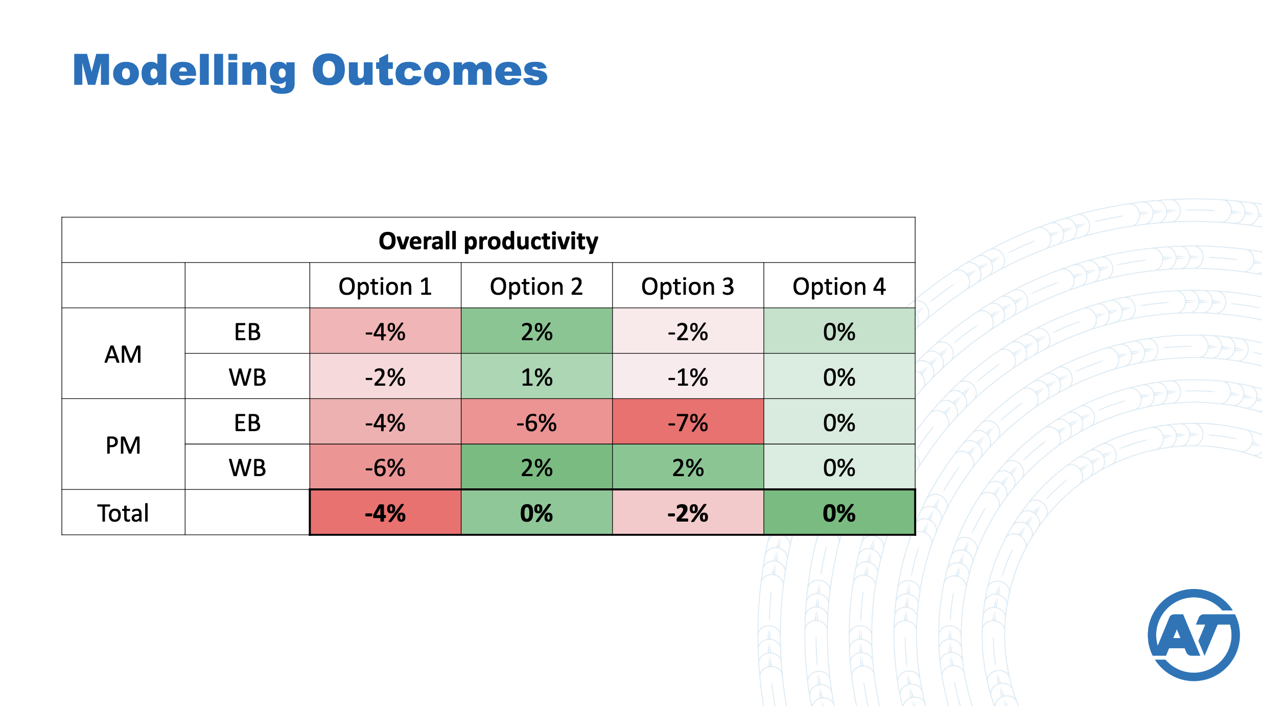
You have to wonder: what “productivity” modelling was used to arrive at this result?
Was safety for people cycling on Green Lane West the first victim of AT’s new target of “being able to travel, on average, 10 kilometres on our arterials in 20 minutes or less” (AT’s 2025 Annual Report)?
If so, then AT’s approach here isn’t just anti-Vision Zero. It’s also playing a fruitless zero-sum game, by chasing travel-time savings for driving due to the Downs-Thomson paradox, aka the Jevons effect, aka ‘induced demand”, familiar to transport engineers.
(If this is news to you, the Utopia explainer remains the gold standard.)
And by the way, focusing on minor travel-time savings is specifically warned against in the Transport Emissions Reduction Pathway, aka the TERP (see p66 here).
AT’s approach contradicts Council’s (and AT’s!) plans and policies
On a road with the traffic speeds and volumes of Green Lane West, AT’s own Urban Street and Road Design Guide says you must have separated cycling facilities (see p40 here).
![]()
The screenshot above is from AT’s 9 February 2026 letter in reply to our LGOIMA, which quoted the escape clause highlighted in the image:
“In some constrained cases, facilities providing a limited Quality of Service may be accepted.”
but conveniently omits what follows:
“This may be as interim investment as a connected network is developed over time, or where a network provides alternative desirable routes.”
Show us these alternative desirable routes – we guarantee there aren’t any!
Moreover, Green Lane West is identified as a strategic regional route on Auckland Transport’s Cycle and Micromobility Strategic Network. And the Transport Emissions Reduction Pathway requires walking and cycling networks to be largely delivered by 2030 (see page 29 here).
So, missing this opportunity would be quite the own-goal, given the city will just have to come back in a few years and deliver proper cycleways, at greater expense.
And, given the impending governance changes, it’ll be the Mayor and Councillors holding the ball – with AT having walked off the field.
A prime opportunity to build the bike network, fast and affordably
The 2023 design (Option 1) would create 2.3km of new fully protected cycleway, along the south side of Green Lane West, from Wheturangi Rd to St Andrews Rd.
It would dramatically improve safety and access for people on bikes in the heart of the isthmus, an area currently dubbed the “Bike Bermuda Triangle” for its lack of safe infrastructure.
Moreover, it would connect Green Lane West to the wider bike network via the roads through Cornwall Park and the planned Onehunga cycle connection beyond.
Plus, it would allow for safer onward journeys to the city, via Melville Park and the University of Auckland’s Epsom campus.
This is a prime opportunity to deliver a prioritised bike route, via an efficient and affordable “dig once” approach as prized by Council, leveraging the existing infrastructure to amplify the network effect. A thrifty engineer’s dream!
AT’s Onehunga Cycle Connection, towards Cornwall Park: under investigation.
An easy win, desired by local stakeholders…
In terms of stakeholder support, you couldn’t find an easier slam-dunk. For one thing, Green Lane West has no street parking and no on-street businesses or residents who could claim to be negatively affected.
You also have a supportive local board, which for the last decade has consistently – and bipartisanly – advocated for regional funding of a safe crosstown cycling route along this alignment (see RLTP/ LTP feedback from 2018, 2021, and 2024).
You also have plentiful public amenities and destinations along the route, like Cornwall Park itself, the Cornwall Cricket Club, Greenlane Clinical Centre, the Auckland Showgrounds, and several major supermarkets – all of which will benefit immensely from safer access for people walking and riding.
And there are two large primary schools, Epsom Normal Primary School, and Cornwall Park District School – the latter of which apparently has, as well as walking school buses, a bike bus that rides through Cornwall Park and along Green Lane West.
Option 1 would give these kids a dedicated cycleway (plus a signalised pedestrian crossing where a minimal “refuge’ now exists). Whereas AT’s 2025 design offers a shared path past the school (pitting primary school kids against e-bikes), and no crossing at all.
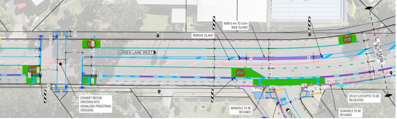
From the 2023 design, showing the two-way cycleway on the south side of Green Lane West, and a signalised crossing towards Cornwall Park District School.
From the 2025 design: no crossing to the school, and a long stretch of shared path (in blue).
…not to mention, required by hundreds of new neighbours!
Then there’s the new apartments at Alexandra Park, which is where we started this post.
The first stage of the development opened in 2021, with 246 apartments housing some 700 residents. Resource consent has been given for the next stage, comprising a further 193 apartments with 164 car parks… and 204 bike parks.
Based on the consent documents, those 204 bike parks are the minimum required under the Auckland Unitary Plan. They reflect Council’s express policy of supporting more cycling by requiring larger developments to provide bike parking (see page 6 here).
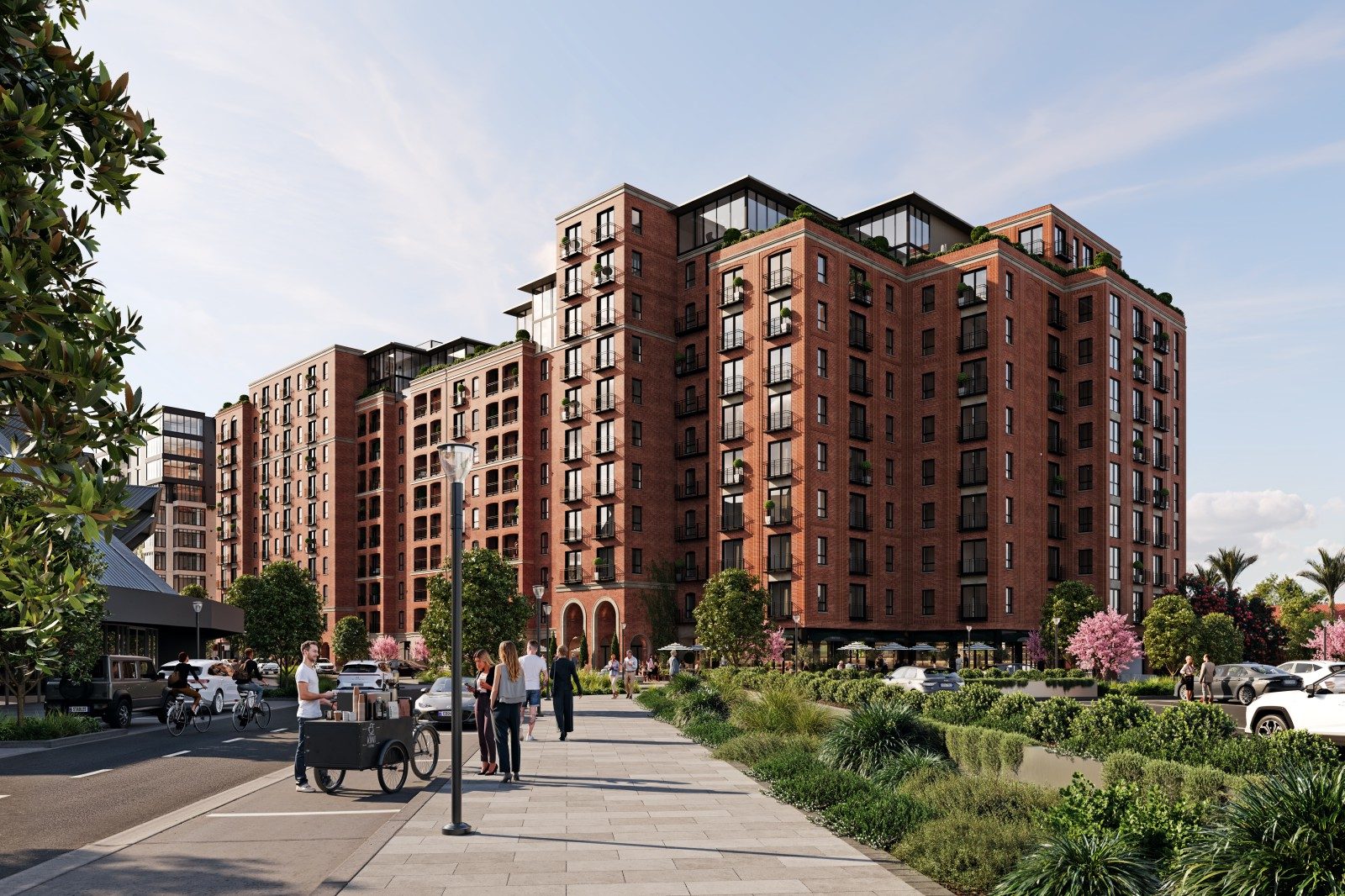
A render of apartments at Alexandra Park, including happy people on bikes. (Source)
The developer’s website leans into the transport options, enthusing about the “boutique fleet of Suzuki Jimnys that apartment owners can rent for short periods instead of the hassle of owning a car”, and highlighting the bespoke bike facilities:
Those that are dedicated to bikes can store them in their own storage locker and spend time in The Stables Bike Workshop. Situated on the ground floor right next to the car park entrance, the Bike Workshop will feature a work bench, bike stands, lighting and shelving for you to repair and tinker to your heart’s content.
As for where these happy people will ride, the NZ Herald quotes the resource consent application (emphasis added):
The heritage gates, wall, ticket booths and turnstile building are proposed to be refurbished and retained at the Green Lane West street frontage of the site and will provide the main pedestrian and bicycle access and entrance to the site.
So Auckland Council is requiring the developer to provide bike facilities – which the developers are enthusiastically delivering – but Auckland Transport is declining to provide the vital infrastructure for residents to get anywhere!
It seems the left hand has no idea what the right hand is doing, leaving Aucklanders stranded in the middle. This needs sorting.
Time to take action!
A fully protected bike route is both possible and essential on Green Lane West, for everyone’s sake.
You only revamp a boulevard like this once a decade, if at all. So there’s a huge opportunity cost if Auckland Transport go ahead with the current design.
But by the same token, there’s a huge opportunity to get it right, including revisiting Option 1 – now that we can all see it. So, let’s help AT avoid landing a sizzling hot potato in Council’s lap…
UPDATE: On Friday 27 February, we received an update from Auckland Transport, which is posted in full at the bottom of this article.
In short: they’re listening, and they hear loud and clear that safety for people on bikes is important. This is positive! And they say:
…we are committed to reviewing the design again to identify any opportunities for cycle lane separation on the current uni-directional design as well as improving the proposed crossings and bus stops for cyclists.
Yes, and: we’re confident the 2023 bidirectional design has strong merits for this location, and is technically feasible. So we’d still like to see that option properly assessed as part of the design review.
Thanks to everyone who’s already taken a moment to contact AT about this – together, we’ve put this opportunity back on the table.
And if you haven’t yet written, now’s the time to let AT know it’s fantastic that they’re listening, that all options should be considered, and that we all want the best outcome!
How to take action
Drop a line to:
- Dean Kimpton, Chief Executive – chief.executive@at.govt.nz
- Melanie Alexander, Acting Director Network Performance – melanie.alexander@at.govt.nz
- Stacey van der Putten, Director Public Transport and Active Modes – stacey.vanderputten@at.govt.nz
And copy in:
- Margi Watson, Chairperson, Albert-Eden Local Board, margi.watson@aucklandcouncil.govt.nz
- Christina Robertson, Deputy Chairperson, Albert-Eden Local Board, christina.robertson@aucklandcouncil.govt.nz
What to say?
Keep it simple – and be polite, encouraging and clear.
- Green Lane West can and should have protected, dedicated space for people on bikes.
- The 2023 design was on the right track, is feasible, and has wide support.
- Building the wrong (or a subpar) design will put people at risk, and waste resources.
- Doing the right thing now is always more affordable than doing it later.
Feel free to share your own experiences of (and expectations for) Green Lane West.
And do share this with others who may be keen to join the call for a great result.
UPDATE: RESPONSE FROM AUCKLAND TRANSPORT, Received Friday 27 February
From Chris Martin, AT Acting Group Manager Road Network Operations
Auckland Transport (AT) would like to provide an update on the Green Lane West Corridor Improvement Project in respect to your article published yesterday: Help Auckland Transport get it right on Green Lane West – Greater Auckland.
We would like to confirm the next steps for the project as we work through public engagement feedback and revising the design based on this.
The project aim is to optimise Green Lane West, within the current road boundaries, to improve the overall productivity of the corridor. This means improving facilities for public transport, high occupancy vehicles, cyclists, and pedestrians to give customers viable and safe mode choices.
A number of options were developed as part of the design process, and subsequently subject to robust and lengthy review by subject matter experts. Some of these options (including the introduction of a bi-directional cycle lane) were not advanced due to being technically unfeasible or misaligned with project outcomes.
We have now received around 700 submissions including from key stakeholders including Bike Auckland. At this early stage we can advise that the improvement of cycle facilities and cyclist safety is a key theme in approximately 40% of the submissions.
As part of listening and responding to public feedback, we are committed to reviewing the design again to identify any opportunities for cycle lane separation on the current uni-directional design as well as improving the proposed crossings and bus stops for cyclists.
We are also investigating whether the extension of cycle facilities to St Andrews Road can be included in the project. We are confident we will be able to refine the design to provide better facilities for cyclists which is supported by a clear desire for cycling on this route coming through from the public feedback.
We are currently working through feedback themes and planning to share feedback first with the Albert-Eden Local Board in April. This will include the feedback summary and any changes we are considering to the design as a result. Once we have done this, we will circulate this information to those who submitted during the public engagement and publish this on the project webpage.
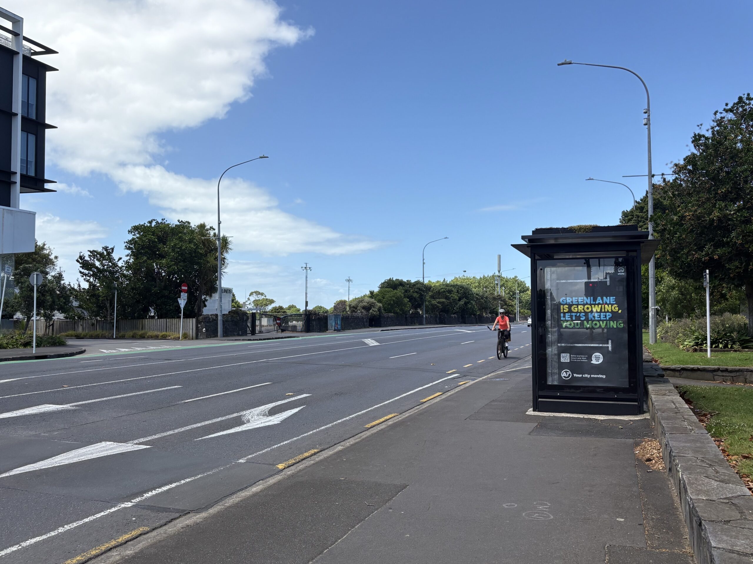
The state of it: Green Lane West as it currently stands, only the bravest brave the bike lanes. The 2025 design makes the painted lanes a bit wider, with sections of shared paths. The 2023 design would have a two-way protected cycleway on that side of the road.
Greater Auckland’s work is made possible by generous donations from our readers and fans. We’re now a registered charity, so your donations are tax-deductible. If you’d like to support our work you can join our circle of supporters here.

 Processing...
Pool vehicles are an interesting topic, we have a whole carpark of pool cars to use at work (air-conditioned, built-in stereo, zero effort, etc.), and then we have 2x pool bicycles (share the road with everyone else and risk getting run over on your way to a site visit).
It’s easy to see how the car brain thinking starts, “what idiot would pick the bike?”
This is prime example of waste.
AT invest in a whole design, one that complies with higher order strategies and plans, is economical, and evidence based. Then someone or someones unknown, either management or governance, determines they must be expensively done over, for a poorer outcome, all under the ever useful screen of “modelling”. On the sly, anonymously and secretly.
In order to, presumably, either comply-in-advance of anticipated political level anti-cycling push back, or because they themselves preference culture-war based reckons over safety, efficiency, and actual evidence.
Will this waste and manipulation end with AT now in house?
Only if the decision-makers (Councillors, Local Board members, and Senior managers) are better educated.
Can we arrange regular snappy presentations on a key topic in the public section of their meetings?
I will gladly donate some time to help create material like slides/handouts if that would help, to back up speakers who know the topics inside and out. GA, you know how to reach me.
I’ve never known moving transport planning closer to politicians to make things go smoother and decision-making more logical…
The left hand knows quite well what the right hand is doing, and hates it, undermining it at every opportunity. But in this case, the decision to first “model” the better design – using outdated models, in order to ignore it – was made under a senior manager who’s now left.
Council needs to step up in these cases towards the end of the current arrangement with AT, and call total bullshit.
There’s no excuse not to return to that earlier design. If any technical issue arose, AT has the opportunity to switch to something much better. These isthmus intersections can, typically, fit the single lane Dutch roundabout for all modes. The straights on the arterials can fit properly wide footpaths, trees, protected ample bike lanes, one traffic lane in each direction, along with stretches of bus lane to allow the buses to overtake congestion. You could even allow some classes of commercial vehicles in, where there aren’t so many bus services. Such a design would improve access and traffic flow, cut out the huge intersection distances that the multiple stacking lanes at intersections create, and therefore reduce the delays everyone experiences waiting for long traffic light phases.
Doing this in combination with other VKT-reducing measures, of which there are many, simply constitutes modern transport planning. Auckland hasn’t seen it yet, because the automotive and oil industry shills in AT have been preventing it.
Proper adoption of the TERP would have seen anyone using the outdated modelling, in service of car dependence, stripped of strategic decision-making (and professionally ridiculed).
Rephrase; “The right hand knows quite well what the left hand is doing”
Outside pressure to achieve a particular definition of productivity is the big problem. If there is enough concensus on what place a productivity measurement should have in making a decision, then better can be possible.
One other problem is the bottleneck of the heritage walls and the Cornwall Park Trust land ownership. Is there room for something useful behind the wall? Could that make for a good result?
All hail the almighty car, none shall encroach on our precious roads. But nothing is sacred when talking about what to demolish in the name of building more lanes
Reminds me of that classic quote: “You aren’t stuck in traffic, you are traffic.”
The earlier tika AT design did not jump the stone wall, so while it may be worthwhile engaging with the trust to explore some sort of path, maybe just a pedestrian one, on their side of the wall as an option, it isn’t relevant to the issue of the sneaky abandonment of the first scheme.
The idea of a “heritage wall” is very funny.
Was the wall built under Emperor Hadrian? Was it built to keep the Mongols out of China? No? Then it’s probably not significant enough to make the street design worse.
And here we see the lack of the secret sauce that makes bicycling in the Netherlands so good even on arterials.
The secret sauce is 50m wide corridors for arterials.
The thing is you just can’t fit car lanes, bus lanes, bike lanes and footpaths into one chain of width. So if you want bike lanes, you’ll have to also say which of those other things to drop.
And yet, the 2023 design evidently manages this? So…
Yes so the answers there are:
On the slightly wider sections it has a bidirectional bike lane on one side instead of bike lanes on both sides, which I guess is OK.
On the narrower sections near Great South Road the thing that gets dropped are the bike lanes — you’re effectively asked to ride on the footpath there. That can work if there aren’t many pedestrians and cyclists. We’ll see.
There’s already an off-road cycle path between GSR and Wheturangi Rd, which is why the design stops at Wheturangi.
Drop on-street parking first.
Medians and general traffic lanes next.
Then turning lanes.
Then bus lanes.
Then bike lanes.
Lastly footpaths.
Minimum viable product is a shared space accessway that will squeeze a bin lorry, but that’s not exactly an arterial.
The Dutch secret sauce isn’t the width of the big arterials.
Look at Groningen: anything which isn’t a limited access highway has all modes covered, typically within 20m width, with on-street parking to boot.
You want to cross town? The quickest way to drive is probably to hit the ringroad highway and come back in the other side.
This. Thanks.
We have 50m wide corridors on our arterial roads. Look at Ti Rakau, Te Irirangi, the motorways, sh20B. The difference in the Netherlands is that they dont provide four car lanes on every single collector road.
Yes these exist but they are a bit unusual. Most have the usual 1 chain width (20.1m). Notably, former tram lines like Mt Eden Road and Dominion Road. There needs to be a standard design for that width. Maybe it will involve having bus lanes on only one side (perhaps 50/50 in the direction towards traffic lights).
And indeed Green Lane appears to be a bit wider. A lot wider in the curvy bit but I think they achieved that by demolishing the houses on one side across a few blocks. That was proposed as an option on Dominion Road, but eh maybe not.
And on Ti Rakau drive, yes good point, that should be plenty of width but we can’t even bring ourselves to use some of that space for the busway.
I wonder if the bike lane and footpath can go through Cornwall Park instead of staying on the side of the road. That isn’t much detour and will give some reprieve from being on a busy road.
Somebody mentioned that possibility here last year. Would require also persuading the park’s trust board, but a much more pleasant prospect for that part of the route.
Doesn’t help people who’ll live on this stretch of Green Lane or going to some of the businesses.
GA article: can we please build some cycle infrastructure that was proposed and designed years ago without re-doing the planning to water down and remove the best parts of it?
GA comments: how can we re-do these plans to water them down and make them more complicated and expensive?
You lot are exemplary of the exact planning loop issue government is experiencing that makes it impossible to build anything. Also experience tells if this was to be built, all the local car owners would be outraged and demand the cycle lanes be removed effective immediately.
And every time plans like this have to go through a new iteration, guess what – it’s your rates that are paying for the re-design process.
There’s perhaps one commenter dubious that the design will fit everything, but clearly eager to see it done. Another commenter saying there’s “no excuse not to return to that earlier design” and questioning the transport paradigm.
There’s literally nobody suggesting AT should go through a new iteration.
Sounds like we’re all in agreement then
re “AT’s Onehunga cycle connection – under investigation”
Despite years of conversations with AT and Panuku (that was) now AUDO around reopening the Onehunga public wharf to the … public …, here again we see investigations of Onehunga cycling connection with no regard to the Onehunga fast ferry service that, if public were able to use the publicly owned wharf, services would be enabled.
Commuters from massive new greenfields developments around the Manukau harbour are getting sick of crawling into the city on the choked up autobahns, and have been asking for the ferry service since it was cancelled in the 1950’s (when the roads were faster)
This is news to AT, clearly.
Onehunga fast ferry?
I’m so sick of AT hiding the good stuff from view and going ahead with crap.
Greenlane and Mt Albert Road are the two that need work for isthmus cycling to be viable. The roads into the city all have bus lanes, which while not ideal, are much better than riding in car lanes.
Mt Albert Road requires the stupid Royal Oak Roundabout to go, but AT seem to have no money for something as simple as that, it’s all spent on billion dollar mega projects.
Great summary, thank you!
FTR at least one councillor supports too
I wonder if the decision to ditch it was made by [former senior AT executive] back in the day… I would not be surprised.
I would suggest that whatever they design , they continue at last to Potyors Park. The most dangerous part of Greenland/Balmoral is the bit between St Andrew’s and Mt Eden Rd
Not many potholes but many many metal covers that are worse than potholes all over the lanes on this area of GL Rd W…Lousy finishing by the rad sealers…bang bang bang…
Bruce M
The update letter from February you added above states AT are “planning to share feedback first with the Albert-Eden Local Board in April…. Once we have done this, we will circulate this information to those who submitted during the public engagement and publish this on the project webpage.”
Now it is May, so presumably they’ve shared it with the AELB, but it’s not yet on the website.
Anyone heard anything?