The government have announced more details about their plans to require even more density around some train stations to make the most of the City Rail Link.
A few weeks ago, Chris Bishop who is the minister for both transport and housing, announced changes to how Auckland processes its zoning changes in response to government requirements for allowing intensification. As part of that, he also said new rules were to come in to require even more density in the areas around the Maungawhau, Kingsland, and Morningside train stations to make the most of the City Rail Link, saying
“As I’ve indicated, the Government is keen to see greater density around public transport, particularly City Rail Link stations. The Bill therefore now also requires Auckland to allow for greater density around the key CRL stations of Maungawhau (Mount Eden), Kingsland, and Morningside.
“Auckland Council must enable within a walkable distance from these stations heights and densities reflective of the higher demand for housing and business in these areas. This requirement goes further than the existing requirements under the NPS-UD, and I expect heights and densities that ensure we make the most of the opportunities offered by this transformational transport project.
“The government is also considering whether further amendments to the Bill to fully maximise development opportunities around other CRL stations as necessary, and I will have more to say in due course.”
Yesterday he and Minister for Auckland Simeon Brown announced the more detail around this.
“The Bill currently provides that Auckland Council must enable within a walkable distance from these stations heights and densities reflective of the higher demand for housing and business in these areas, and at a minimum, no less than six storeys.
“The Government has decided that these requirements, while a step forward, don’t go far enough. The Government will therefore move an amendment to the Bill at the Committee of the Whole House stage, which will do the following:
- Extend the requirement to enable heights and densities reflective of the demand for housing and business to two additional stations: Mt Albert and Baldwin Avenue.
- Require upzoning allowing buildings of at least 15 storeys high around the stations of Maungawhau (Mount Eden), Kingsland, and Morningside.
- Require upzoning allowing buildings of at least 10 storeys high around Mt Albert and Baldwin Avenue stations.
“Both Mt Albert and Baldwin stations are ripe for development, sitting close to Unitec’s campus and Mt Albert’s popular shops and cafes. Increasing development capacity in the area will allow for more commuters and more students to live close to the stations, adding vibrance to these suburbs.
“The Government is determined to fix our housing crisis and a key step toward that is unlocking housing capacity in Auckland. The best place to start is by building housing around high quality public transport.”
“The City Rail Link is a game-changing investment in the future of Auckland. It will unlock significant economic opportunity, but only if we have a planning system to allow businesses and residents to take advantage of it,” Minister Brown says.
First up, this is great, allowing more density around some of the closest train stations to the city centre makes a lot of sense. We also know it’s simply not something Auckland’s planners and politicians would ever do on their own – which is exactly why requirements like the National Policy Statement on Urban Development (NPS-UD) and later the Medium Density Residential Standards (MDRS) were introduced. I do have a few concerns though.
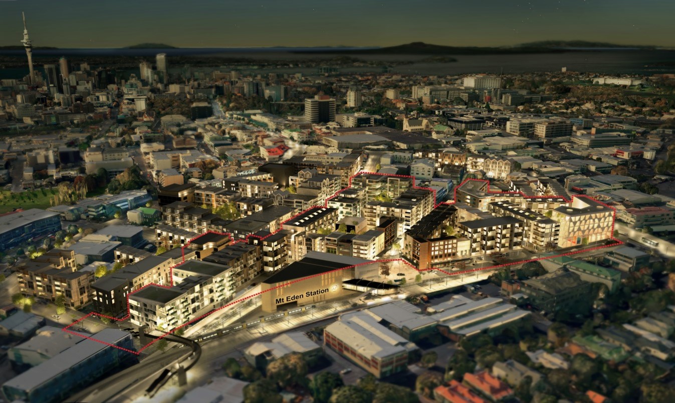
An old render of what might be possible on the CRL site at Maungawhau. The new rules are intended to allow more density all around the station.
Application of the Planning Rules
Given we’ve seen councils tend to be quite conservative with their definition of what walkable is, it would have been good if the government also put some more detail around that. Regardless, we can see the council’s interpretation of that for around the Mt Albert and Baldwin Ave stations from what was proposed by the council for Plan Change 78 which was implementing the NPS-UD and MDRS.
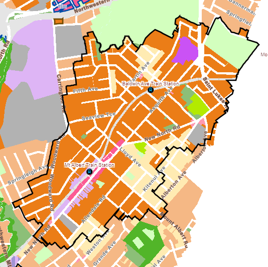
We can’t see what it would be for the other three stations as they were excluded while waiting for the now cancelled Light Rail project but as a guide, the areas are generally around 800m from the station.
The big question will be whether council’s planners try subvert the intent of these requirements through tools like viewshafts and the use of special character areas.
Below is the Unitary Plan condition for these two station areas. Spots show sites with a character overlay, V indicate the viewshafts. It isn’t explicit in the Minister’s text that council is being instructed to over-rule these overlays as well as zoning controls, but without doing so the mandated heights and densities won’t be possible. At this stage it isn’t clear what the process for review or removal of these controls might look like?
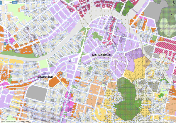
Unitary Plan planning controls inner Isthmus
Train Capacity
These new requirements are about what is allowed, they’re not minimum standards and it doesn’t mean developers will build to 10 or 15 storeys in these areas. Change will also not happen overnight, regardless, even partially delivered it will mean thousands more people could be living in these areas and catching the train, and there’s an issue with that.
While all of our train lines will be benefit from the CRL, thanks to the new stations in the city centre and improved frequencies, the western line gets the additional benefit of a shorter route delivering additional travel time savings of around 10 minutes for trips to Britomart. A trip from Mt Albert to Te Waihorotiu in the middle of town will be only around 15 minutes.
I think it means trains are going be incredibly popular from stations all along the Western Line. Yet AT’s plans and even the current long term rail planning seems to be based around not as much growth in usage from the west as other parts of the network – I think they’re wrong about their demand modelling and will cover it in more detail in a separate post. As such, the west will see fewer improvements in train frequency compared to the other lines and while it won’t be an issue day one, over time, thousands more people wanting to use will put additional pressure on services.
Those plans can (and will) change over time but it will be challenging here due to ….
Level crossings
One of the key constraints to improving frequencies is the need to remove level crossings. Current plans put removing the first western line crossings many years away and it could take decades to remove all of them. However, there are just four between Maungawhau and Mt Albert – George St, Morningside Dr, Asquith Ave and Rossgrove Tce. Removing those and adding an extra platform at Mt Albert (as per existing long term plans) would give the ability to run more trains on the inner parts of the network to address this.
Paradoxically, this announcement could actually make that harder. That’s because land values will go up on the sites close to stations and that is likely to be some of the land Auckland Transport will need to purchase to be able to grade separate some of these crossings.
Especially now that Eke Panuku is being folded into the council structure – and transport planning eventually too, perhaps Council should spend some time to come up with some plans that will enable both the removal of level crossings along with development that makes use of these rules and could even help fund the crossing removal.
What about other isthmus train stations
As mentioned, Mt Albert will be around 15 minutes from the centre of the city. So why aren’t these rules being applied to other stations similarly close, like Parnell, Grafton, Newmarket, Remuera, Greenlane and Ellerslie on the Southern Line or Orakei, Meadowbank, Glen Innes and Panmure on the Eastern Line.
Surely it’s not just because those stations happen to be electorates held by either National or ACT MPs.
This post, like all our work, is brought to you by the Greater Auckland crew and made possible by generous donations from our readers and fans. If you’d like to support our work, you can join our circle of supporters here, or support us on Substack!

 Processing...
100% only being applied to Mt Albert ward because it’s (usually) a Labour strong hold, that said it’s almost shooting yourself in the foot as eventually the less people living in specific wards, the more likely they are going to get pulled into a bigger ward and potentially losing your seat (see Epsom).
Anyway, politics aside and the fact that all stations where its 15 minutes to the City should have the rules applied, its a great start. Would love to see those old rickety Asian Suppermarkets that run between NNR and the train line in Mt Albert turned into a dense TOD. With all this said, Kingsland and Morningside have had multiple consents for apartments approved only for them th stall or fail, so its more than the consenting system thats the problem and we need more than just Ockham to build apartments.
Ironically Labour needs intensification in Mt Albert to avoid gentrification and it voting for the right.
Chris Bishop has indicated he thinks poorer people should live in outlying suburbs.
It does appear blatantly density-for-thee-not-for-me that they are not applying these rules to stations/lines which will have higher frequency services in particular once the grade separation is complete, while the Western line grade separation is literally kicked to decades away. Why can’t they look at low hanging fruit in the interim, some of these crossings can be separated or closed without spending 100 million dollars at each surely.
There are some easy ones on the Western Line (such as George St between Dominion Road and the New North Road); however I don’t think removing them will do much for increasing train frequency (due to the importance to traffic of other crossings on the line).
The changes needed to Morningside and around Baldwin Avenue (Rossgrove terrace and Asquith Avenue) will be pretty substantial. Their importance to movement patterns (whether for the wider area in Morningside’s respect; or the local neighbourhood for the Baldwin ones) means that simply removing them isn’t obviously the best solution.
Morningside should be done for Eden Park and events. Whether it’s vehicle or not should depend mostly on $$$s – I’d say yes for vehicles except I’ve got no faith we can do it affordably. The main importance of the crossing is to handle event crowds, and access to the station. Cars it’s annoying but not too difficult to drive around the block.
Baldwin Ave crossings could be if needed taking some land from neighbours for a path from Rossgrove to Asquith on the north side of the tracks, then closing 3 crossings and putting in a ped bridge and calling the surrounds a LTN – as the cost of keeping locals happy isn’t worth hundreds of millions, they can drive around.
Ideally they’d put a ped bridge where the existing ped crossing is, then if they wanted to keep the vehicle access, buy up a few houses to connect Rossgrove/Asquith then bridge as a lot cheaper than building 2 bridges there.
only ones that really need grade separation are Morningside Dr and Woodward Rd anyway imo.
Unfortunately most of the more important ones on the western line also seem to be the most hardest to remove – St Jude, Morningside, Glenview. At least Portage and Woodward would be relatively cheap (though disruptive)
Sorting out St Jude is going to be the stuff of nightmares to fix.
I have a plan, but yes is expensive and disruptive.
Full closure between NL and Mt Albert.
Both St Jude and Woodward road over, a combo of lowering track and road bridge. Do at the same time. Buses between NL and Mt A. Run outer west and inner west as separate networks for the duration.
Will mean Avondale station rebuild at lower level, opportunity for over station development? A lot of track will also need lowering especially in the city direction. Build pedestrian only crossings at Portage, Chalmers, and St Georges.
Once St Jude is reopened, close other 3 level crossings between Avondale and NL to traffic. This creates a bunch of lovely quiet low traffic neighbourhoods. There are so many new road crossings in NL from when that station was lowered, Portage will be fine in two halves.
Many Asian cities such as Singapore, Seoul, Shanghai, Mumbai have been building large apartments close to stations over decades and benefiting.
There are many studies showing the benefits. The cost of infrastructure in the CBD is much less per dwelling than in distant suburbs. Wellington did such study in 2023. A 2021 study by the city of Ottawa showed that servicing low density greenfield development was $470 per person per year while high density infill or brownfields benefits the city $620 per person per year.
Sprawl has been been very high cost to NZ. People commuting for hours a day. Families owning and maintaining several cars and resulting in NZ having the highest car ownership in the world. Infrastructure cost of building pipes, paths, roads out to greenfields has been very high for struggling councils.
It is disappointing that there is too much angst towards apartment living. Several people I know who are living in the city say they are happy there and appreciate the vibrancy and culture.
Penthouse apartments are the most popular and around the world are most sought after
“So why aren’t these rules being applied to other stations similarly close, like… Panmure.”
Is there any more news on moves to get rid of the viewshafts, which I understand is what’s blocking the land around Panmure station?
I had a look around some old AT and Ministry of Transport documents yesterday out of interest.
Those discussed either 800m or 400m radius from Maungawhau, Kingsland and Morningside. Unsure whether the amendment to the RMA will stick with that.
The devil will be in the detail and I suspect the government to come up with something cack-handed that will favour low spec developers rather than responsible ones like Ockham or Simplicity.
We’ll see though; I hope to be wrong.
I do think it is problematic that nobody seems to enumerate walking distances in these statements. Yes, it is generally accepted that for high frequency PT services, 800m is a good value – but we should really have that be part of the formal statements, or it’s just another matter of debate and argument that can be gamed by everyone.
I would happily train to drive one of those heavy rollers Who Framed Roger Rabbit machines to begin flattening some of those leaky houses impeding progress.
We can create homes for so many more persons, in warm, dry, well designed apartment blocks, creating new communities, and creating a city comparable to the best on the planet.
For those of us who have traveled, we are always waiting patiently for our home motu to catch up, and in my fifth decade my home town may finally become a CITY. A real city, not a “supercity”. Cities are defined by their shining towers of ivory, and although we must only use fake ivory to build ours, let us construct a modern marvel based around our fancy new subway metro rail lines!
bah humbug
The streets around the stations need bike lanes and wider footpaths too. You can’t have that many apartments without providing much better active transport.
So Chris Bishop will need to replace Simeon Brown’s hysterical GPS with something reasonable.
And then give direction that’s unambiguous.
Well yes, but “we can’t do X until Z happens” is just one way that NIMBYs block progress. So I am perfectly fine with density permitted increasing first. Improving access immediately would be lovely, but reality isn’t perfect.
Stumbling incrementalism is what always happens with physical changes – only planning and policy can (sometimes) create sudden changes by throwing out the old and putting in new assumptions.
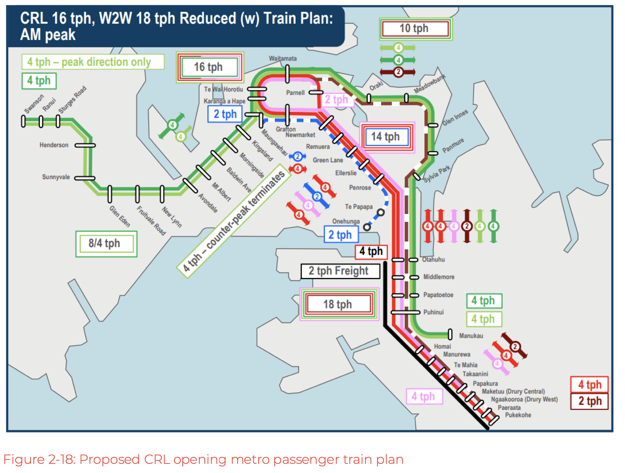
That train plan for sure looks very confusing. Having lines loop over themselves or having “variants” that either go one way or the other depending on the time of the day will not make it easy to use.
There are 3 lines so less than at present. Western that goes through CRL and becomes the Eastern.
Southern which will start Otahuhu, go round the CRL, then end up in Pukekohe. The Southern will have 1 train going clockwise, then 1 anticlockwise and so on from Newmarket purely so they can fit more trains in the CRL.
Finally the Onehunga line which will extend to Grafton (as Mt Eden is missing the platforms) and possibly to Henderson.
The other complexity on the diagram is just about them running more trains at peak.
It’s really only 2 core lines.
I think the southern line folding back on itself is especially confusing and inefficient.
West to MC via CRL and Parnell plus South East to Otahuhu via Grafton and CRL seems both more legible and less wasteful of train movements.
thoughts?
Sounds like this requires (another) post on its own.
MC = Manukau right?
I think the Southern line is fine, but I agree with MP about it better for it’s own post about the post CRL network.
That diagram contradicts others that I’ve seen. Do we have word on what the preferred option actually is?
One option that is much more legible (no confusing double backs) and efficient (less dead running) is:
West-CRL-Parnell-MC
South-Grafton-CRL-Panmure-Otahuhu
Yes, inner west is going to get popular to live around. Good move.
“Surely it’s not just because those stations happen to be electorates held by either National or ACT MPs.” – it has to be doesn’t it, Seymour and van Velden electorates.
Maybe their new red tape ministry can cut the red tape that ACT is applying? Why prevent people developing their own land near train stations?
Don’t let perfect be the enemy of good. It can always be fixed later. Besides, in the long run if they don’t densify their electorates they’ll lose their electorate when it’s merged into another to keep the relative population even.
The sites needed for serious density will require accumulation of private lots – a job for a public agency, empowered to purchase from unwilling owners. Good luck with that.
Also, the question of value capture to fund essential infrastructure still needs to be tackled.
Otherwise, this will just be windfall wealth for lucky landowners who are happy to sell up and move on, at the expense of all rate and tax payers.
Value capture will never happen. Many land owners are NIMBYs that don’t want this change. Sending them a massive bill as well will not go down well.
The Public Works Act can be used for urban regeneration
That was the intent of Kainga ora, they have eminent domain powers.
National and Labour parties both empowered them under the “Kāinga Ora–Homes and Communities Act 2019”
The ability to value capture, was given to them under the “Urban Development Act 2020”, look at sub part 2 of the act.
Central government has the powers right now to force through density now.
Maungawhau station is covered with view shafts. Where are these 15 story buildings going? And that’s before all the other “qualifying matters” are rolled out. Is this just another announcement that leads nowhere?
It is a good idea. So Auckland Council will find a way to wreck it.
There was some urgency about Mt Albert due to these properties recently being sold. Hopefully they were bought by a developer with deep pockets and real ambition.
https://www.bayleys.co.nz/listings/commercial/auckland/auckland/12-mt-albert-road-3-allendale-road-and-878-new-north-road-mt-albert-1699125
Those Mount Albert shops are not popular.
They have great potential to be revitalised by an increasing population though (and increased access). A lovely urban village mostly owned by cheap landlords. Care needs to be taken with these proposed changes that we enhance our neighbourhoods rather than simply flatten and replace them (otherwise the benefits of CRL will purely be enjoyed by property speculators).
Around peak the western trains are already stressed, especially the 3-unit ones. I wonder if their reluctance to increase frequency is more about the number of level crossings on the western line. Especially those like Glen Eden, to lesser degree Avondale/Ranui, where the station/crossing proximity means train arrival and dwell causes lengthy crossing closures. Saint Jude St is bad now, lethal for cyclists trying to navigate the dismal (criminal I think) non-crossing provided for the bike path there.
Add more trains <10min frequency, plus any sort of inbound/outbound offset, and might as well perminently close those level crossings.
https://www.stuff.co.nz/nz-news/360593811/west-auckland-citys-poor-cousin-no-funds-remove-level-crossings-ahead-crl-opening
100% is the case. Basically instead of sorting the crossings or changing the rules, they’re just going to reduce the frequency of trains out west. Reason they’re focusing on the southern line is that’s where the majority of freight trains go.
I think its misleading to refer to these stations as ‘inner west’ inner west is henderson / swanson.
According to who? AT has their ‘inner west’ projects referring to projects in Grey Lynn, Pt Chev, Westmere etc. Similar with media coverage. Henderson is just west.
The inner refers to the inner suburbs (think old Auckland boundaries), then West to show the subset, Western suburbs of the inner suburbs.
I live in Swanson, it is definitely outer west. Anything beyond Waitakere township is Northwest (just like Kumeu). Inner west has always been Avondale and Blockhouse Bay, the western extent of the isthmus, i.e. the old Auckland City boundary.
I’m wondering about plot ratios, required set backs and how they’d increase with height.
We’d had some terrible apartment planning in the CBD. Rules have been changed but I suspect they’re still not good. For neighborhoods of 15+ storey towers, we’d better get it right. Copy the rules in Singapore, where this type of building has been common for a long time, and towers have plenty of space between them.
Slightly tangential question – if travelling from Otahuhu to Waitemata will there be options that go via Karangahape and Parnell? Or will all services go only one way round the loop?
Sadly it looks like there will be both, which will be confusing.
I think it would be much better if there is an unchanging service pattern in a direction on a certain service. But because of the double back on itself by the southern line every train will need some additional identifier about which way it is going through the CRL. It looks like it’s going to be as stupid and un-understandable as the Melbourne city loop patterns.
Even more confusing with one direction only peak service terminating in the city overlayed as well.
Plus of course from Otahuhu you can go to Waitemata and rest of the CRL via the eastern line. Otahuhu will always be the absolute heart of the network, no matter what service pattern is selected. Time to improve its’ surroundings and access.
Thanks for the reply Patrick. Love your guys work by the way.
Finally time saw change!!!! Good start National, but not enough to get more high density sitting in ‘walkable station catchments’ in Auckland! There’s a real need for more to done! Auckland needs more ‘New Density Rules’ implemented in Eastern & Southern line suburbs. For Eastern line, Glen Innes, Panmure & Sylvia Park. For Southern line, Newmarket, Greenlane, Ellerslie & Otahuhu.
To add, National needs to actually focus tackling the ‘Cost of Living’ if wants to survive another term in parliament instead of being too ‘Business centric’! Everyday Aucklanders particularly need ‘Cost of Living’ to go down. Building more ‘rapid transit’ whatever it maybe would significantly help ‘Cost of Living’! Lots of commuters are asking for more faster rapid transit to commute to work due to the enormous congestion during peak hrs. During weekends the main streets are clogged with traffic every weekend! A focus on building on more rapid transits that doesn’t include Northwestern Busway, Eastern Busway Stage 2-3, Botany to Airport and Southdown-Avondale (Southwestern line) would help everyday Aucklanders right now! Building Northwestern Busway, Eastern Busway Stage 2-3, Botany to Airport and Southdown-Avondale (Southwestern line) will only reduce bottleneck in their areas, but won’t help other areas in Auckland which are bottlenecked due to other services over-capacity and are in-need of ‘rapid transit’. There are main road corridors in Auckland which get heavily congested due to no fast rapid-transit getting built to fully diagnose the congestion problem. Congestion is interfering with commuters daily lives, particularly couples with kids & old couples by taking away their quality of life meaning less private life/meaningful life. Building more ‘rapid transits’ would improve commuters quality of life. Price of using PT would reduce too if Auckland was building more ‘rapid transits’.
Rapid Transits that government needs to look into is North Shore Heavy Rail, Dominion RD Heavy Rail, Onewa Rd Busway and SH18 Busway.
With the Northern Busway, Building an extended version of the current Northern Busway to Fanshawe St will only temporarily reduce congestion within 10 year timeframe and be back to same issue all over again. It’ll increase bus-use, as years go by, the Busway will be back to same issue of amount of buses using in an hr during peak. Building a North Shore Heavy Rail line only solution to fully diagnose the bottleneck/congestion issue! Same goes for Dominion RD and other main corridors which need rapid transit due to their corridor being bottlenecked/over-capacity. Takapuna not going to see more high density residential complexes and become a Metropolitan anytime soon since its not convenient to commute or quick commute via public transport from CBD and currently one bus only goes directly to Takapuna from Midtown, not from Britomart, Newmarket & K Road. Which makes residential investing in Takapuna undesirable due to lack of flexibility and direct options of PT routes for potential residential buyers to live/stay.
Another with Auckland suburbs, we don’t have a single ‘Connection point station’ that has more than three or four rapid transits at one ‘Connection point station. Which is key reason why property investors wanting to invest in high density residential complexes and construct in our ‘Connection point station’ suburbs, due to lack of flexibility and direct options of PT routes for potential residential buyers to live/stay.
should be
– North Shore automated light metro
– Northwestern automated light metro
– Dominion Road light rail (i repeat, surface light rail every 5 minutes has far superior capacity and convenience than your tunnelled heavy rail every 20-30 minutes with deep stations that take minutes to get from street level to platform level.)
– Airport to Botany as green tracked surface light rail instead of busway
– Onehunga to Airport could be heavy rail, light metro, or light rail; depends on whether rebuilding the Penrose-Onehunga branch, connecting to the surface light rail at Mt Roskill, or a light metro tunnel to meet the North Shore & Northwest lines in the central city, is the best value.
for someone who bangs on about rapid transit you still don’t realise that FREQUENCY not speed is the cornerstone of rapid transit. A train/tram/metro/bus every 10 minutes off-peak, minimum, on each line.
– North Shore will be Heavy Rail from Britomart
– Northwestern Busway converts to Heavy Rail joins into Kingsland
– Dominion Road Heavy Rail, Mt Roskill residents emphasized they don’t want 4 tracks corridor in Southdown-Avondale due to kids safety, only room for Heavy Rail
“rapid transit you still don’t realise that FREQUENCY not speed is the cornerstone of rapid transit”
SPEED IS KEY! FREQUENCY A BIG NO, NO! Commuters only really care about PT duration and determining the speed based by time of commuting from A to B! Commuters don’t want slow granny vehicle that takes up your personal time!
Commuters don’t want to wait half an hour at a station either. That absolutely cancels out any speed advantages of heavy rail (and when the current network operates so slowly, with painful dwell times, i doubt
How is that such a difficult concept for you to understand?
oh, and light metro and light rail both can run up to 100km/h. don’t know where you’re getting this “granny vehicle” idea from – the PTUA’s anti light rail propaganda?
let’s say your hypothetical $7 billion magic heavy rail tunnel under Dominion Rd takes 15 minutes from Te Waihorotiu to Mt Roskill. But with a 20 minute frequency, that means the trip could be as long as 35 minutes if you miss your train.
Meanwhile surface light rail was calculated in 2018 to take 20 minutes midtown to Mt Roskill. But with a frequency of every 4-5 minutes at peak, if you missed your train your journey time would take 24-25 minutes. So on average; light rail would be quicker for most people.
And that’s not even including the 1-3 minutes it takes to get from an underground station to the street level, at both ends of the trip; while surface light rail lets you get on and off closer to where people need to go… your heavy rail is looking more like 20-40 minutes range of travel times from Mt Roskill, while light rail would be 20-25.
Facts are just not on your side Anon. This nonsense opposition to light rail and driverless light metro is illogical, and your inability to understand that frequency equals convenience and faster travel does not do transit advocacy any favours. 10 minutes is the maximum that most people are prepared to wait for a train if they miss the previous one. And they shouldn’t need to work around a timetable. Turn-up-and-go frequency means someone can go catch a train, metro, tram or bus anytime without checking a timetable. it makes public transport as convenient and attractive as driving
National, if you want to win the next election cycle, you need to set a focus on more build on ‘rapid transits’, letting go some current roading project for next election cycle for ‘more rapid transits’ which is badly needed in Auckland! Most people Auckland fed up with lack of rapid transits present in our suburbs due to no alternative faster public transport option that bypasses general traffic and PT vehicle riding designated rapid transit corridor. People are fed up with the long commutes 3-4 hr commutes each day and lack of multidirectional fast, direct PT services to get into CBD area. There’s a need for more Rapid Transits in Auckland!
https://www.rnz.co.nz/news/business/532079/construction-of-300-build-to-rent-houses-in-remuera-set-to-begin
Great to see this near Greenlane station. But to put some perspective on this, 330 appartments in a $280 million development. Not many development companies in NZ can do that.
“Not many development companies in NZ can do that.”
Exactly my point! Many NZ property investors/developers don’t want to take massive risk incase property units, later to find ones vacant long period of time and not get sold at all cause of lack of 3 or 4 rapid transits at single ‘Connection point station’ in Auckland! Many NZ property investors/developers know for potential residential buyers to live/stay expect flexible, versatile and direct options of PT routes to get to work.
15 stories around Kingsland heading down Sandringham road will be a difficult sell to developers. There has been the ability to build up to 6 stories between Kingsland and Balmoral Road for years along the Sandringham Road corridor, and only one building above 2 stories has been built (corner Sandringham and Truro Road).
The whole area sits on the Mt Eden lava flow, and has unpredictable geology (layering of basalt). It was a swamp up until 1930’s (suprisingly it suffered in the 2023 floods).
This leads to high geological surveying and foundation costs to enable these taller (high pile load) buildings.
In addition, any upgrades existing services to existing services will be extremely expensive (the area still has overhead power lines, and some fibre is delivered above ground), and no storm water system.