With a public holiday for Matariki tomorrow we’re kicking off our weekly roundup a day early. While it may be a short week there’s no shortage of news that caught our attention.
This week in Greater Auckland
- On Tuesday Connor revealed the last government’s light rail switch.
- On Wednesday Matt covered Auckland Transports announcement of an expansion of their bikes on NX1 bus trial.
This post, like all our work, is brought to you by the Greater Auckland crew and made possible by generous donations from our readers and fans. If you’d like to support our work, you can join our circle of supporters here, or support us on Substack!
Ticketing Challenges
Is there a public transport ticketing roll-out that hasn’t encountered huge problems and delays? Moto Move, the nationwide transport ticketing system is having issues.
“No options are off the table” to get the National Ticketing Solution back on track, the Transport Minister says.
There has been $1.4 billion set aside for the New Zealand Transport Agency (NZTA) Waka Kotahi project named Motu Move that would allow commuters to easily tag onto public transport anywhere nationwide.
It had been beset with delays and councils covering regions such as Wellington and Auckland have raised concerns about the project.
NZTA Waka Kotahi planned to announce a delayed rollout plan for the National Ticketing Solution for areas outside of Canterbury where it was being trialled.
That was expected to be announced in August.
At Tuesday’s transport and infrastructure committee meeting Transport Minister Chris Bishop said he was “worried” about the project.
“I had the governance group in my office ten days or so ago and made it really clear to them that it is a government priority to get the project back on track.
“It is not on track at the moment.”
…..
Bishop said that part of the “challenge” for the project was that public transport authorities were pushing to retain their fare concessions.
“There are really niche, bespoke concessions arrangements in some PTAs (public transport authorities).”
All of that raised cost and time, Bishop said.
He said the other problem was the governance group.
“The way it’s structured is you know unless everyone agrees nothing moves forward.”
We recall having to HOP having similar issues in trying to accommodate all of the various ticketing structures that existed at the time. Both then and now I wonder if some effort should have been spent upfront to standardise fare structures to make the technology implementation easer.
As mentioned, New Zealand isn’t alone here. This week we also saw a reporting that Perth’s efforts to upgrade it’s ticketing system to allow passengers to use credit/debit cards and phones to tag on, like was implemented by Auckland Transport for HOP last year, is six-and-a-half years behind schedule and way over budget.
Strand Optimisation Stage 2
Improving The Strand is an important project but there were concerns after stage one kicked off without the shared path that was originally planned, especially as later stages have a bad tendency to never happen and the then Minister of Transport’s aversion to any improvements for walking and cycling.
So some good news that works started this week to deliver it.
Construction of the Strand Optimisation Project – stage 2 improvements will begin on Monday 16 June, with a shared use path along the footpath and berm of the eastbound (city side) of State Highway 16 The Strand in Parnell.
This will improve safety, road efficiency and productivity along this busy corridor as both pedestrians and cyclists will have a separated path from the busy road.
Most of the construction will be carried out from 7am – 5pm, Monday to Friday and will not affect traffic travelling along SH16 The Strand. However, there may be occasional shoulder closures. Pedestrians will still be able to walk along The Strand but there may be traffic control in the sections we’re working in.
The shared use path will connect to the existing Grafton Gully path just prior to Alten Road. It will follow the existing path on Churchill Street to the new signalised crossing (to be installed by Commercial Safety Vehicle Programme), then run along Beach Road and The Strand, connecting to the rail overbridge.
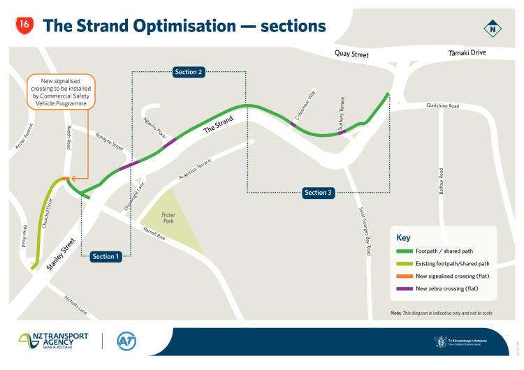
The work is expected to be completed in October.
Watercare Capacity Maps Updated
Last year Watercare caused a housing stir after they released maps showing where capacity constraints were on their network. They’ve now released an updated version to better reflect the constraints.
Head of wastewater planning Andrew Deutschle says the map was first published in November last year to show developers where there is capacity to support growth, and where there are limitations.
“However, there’s been a misperception that any area identified as having a limitation was closed for development. This is not the case. In fact, of the more than 3400 queries we’ve responded to since publishing the maps, we’ve confirmed capacity is available in more than 3000 cases.”
Previously, some areas on the map were displayed as having either a water or wastewater limitation, or both.
“We recognise it’s more useful for potential developers to understand the status of each area, rather than the particular limitation, so as part of our commitment to regularly review and update the map, we’ve changed the way each area is labelled and provided more explanation on our website,” Deutschle says.
“We have also further analysed our network data, including the frequency of wastewater overflows, to ensure we have the right areas noted on the map, and appropriate controls in place to protect the environment.”
As a result of this work, the map shows new zones where our team is closely monitoring capacity. These include Glendowie, Otāhuhu, East Tāmaki/Flat Bush and the Epsom/Newmarket/Remuera area.
“These areas generally have capacity in the bulk infrastructure – that’s our treatment plants and large pipes – but we’re keeping a close eye on them as they may be experiencing more overflows from the network, or there may be limitations in the water supply network in the future,” Deutschle says. “We may need to decline some larger developments at resource consent stage, depending on the specific location and impact to our networks.
“It’s possible that these areas could have capacity limitations in the future, so we wanted to give developers as much notice as possible by including them on the map. We are developing our infrastructure programmes to support future growth in these areas.”
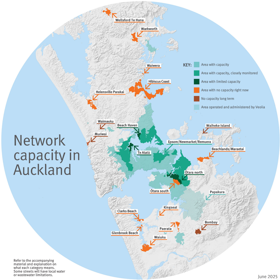
As a reminder, this was the original map and one thing that remains unchanged is there’s plenty of capacity in the central isthmus, if only the council allowed housing there.

Art and the City
Emily Trent is Head of Arts and Culture at Auckland Council so she knows why a city needs art, and how art contributes to the quality of our regenerating midtown.
The Auckland Council group is reinventing midtown, ensuring it’s ready to serve the city well ahead of the City Rail Link opening in 2026.
…..
Against a backdrop of the city’s magnificent, multi-sensory artwork Waimahara in Myers Park, we ask Emily why art is important in any urban regeneration, and in this regeneration in particular.
This Q&A is part of an occasional series shining light on the regeneration of midtown and some of the people who are playing a part in it. The Auckland Council group announced an investment of $155 million in multiple projects to regenerate midtown in September 2021. Many are delivered already.
Our Q&A with Emily Trent:
Why does a city need public art?
Art is the way a city tells its story. Art defines who we are in the world. It delights and surprises. And right now Auckland’s midtown is a living example of that.

Finishing the CRL
Stuff’s Lloyd Burr takes a look inside the CRL and why it is still some time away from opening
The tunnels were completed more than two years ago, trains are running through them already, and the stations have branding installed – so why won’t it be open until some time in 2026? Explainer Editor Lloyd Burr heads underground to find some answers.
…..
But given the tunnels were completed more than two years ago, the tracks have long been installed, and test trains have been going up and down the route, why is the opening still so far away?
The answer: There are a lot of moving parts that have to work together. Let’s look at them.
And as a reminder, the rail network will be shut down this weekend for more works to get it ready for the CRL.
Speaking of underground stations
Climate Crossroads
Perhaps we should listen to the insurers?
IAG NZ chief executive Amanda Whiting said the country was approaching a crossroads and faced having to make key decisions.
“We can commit to reducing risk and investing in resilience and adaptation to help keep insurance available and affordable for as many people as possible.
“Or we can keep doing what we are doing and risk rising costs, reduced coverage, and the possibility that some homes may become too risky or expensive to insure.”
Seventy-five percent of respondents said it was the government’s responsibility to act on climate change, but Bryce Davies said that while government does have a responsibility around infrastructure, it was not a simple of question of money.
He said the survey highlighted that people believe central and local government, business and individuals all have a role to in climate action. But what is needed from central government is good leadership, ensuring that good decisions are made around areas such as urban planning.
Reframing speed
Meanwhile from Tasman, an interesting question of what signs will lower speeds the most, a speed limit sign or a speed advisory sign.
Are you more likely to obey a speed limit sign or a yellow advisory sign?
That question is at the heart of Tasman District Council’s final round of speed limit consultation, which has now opened.
The focus of this consultation is on narrow and winding unsealed roads, rural residential roads, urban roads without footpaths, and a selection of other specific roads.
…..
The key piece of data driving the question is that the average speed on Tasman’s narrow and winding unsealed roads was between 17 and 42kph – already far below 60kph.
While driving on these roads at 100kph is generally unsafe, it is legally allowed.
Bringing the speed limit down to 60kph would ensure the legal speed limit was more appropriate but would still be faster than most of the existing speeds.
Before consultation opened, Tasman’s mayor expressed reservations about lowering the speed limits, which would require more speed signs to be installed, “given we know that people treat speed limit signs as targets”.
“The question for us is ‘what form of information will most likely result in a reduction in speed on those roads?’” Tim King said.
“Because at the moment there is no sign on the road, nothing… People are driving at 25[kph] or 31 or 42 because of the conditions.”
He instead wondered if putting up more yellow advisory signs would be more effective in ensuring drivers continue travelling at safe speeds.
OPEX eats CAPEX over time
If this reporting is correct, it really highlights how we often put short term costs ahead of long term savings.
A mandated transition to electric buses from central Government and “zero dollars” in funding has Waikato Regional Council leaders grappling with how to tackle a bill of up to $330 million.
And the burden looks likely to fall on ratepayers.
In January 2021, the Government announced it would require only zero-emission public transport buses to be purchased from 2025, with the target to complete decarbonisation of the public transport bus fleet by 2035.
…..
“We’ve got a mandate, but there’s no funding.”
The $136.95 million the Government agreed to through Budget 2022 to support decarbonisation of the fleet has now gone, said Hansen.
…..
Modelling put the cost at $45 million to roll-over the contracts as they are now with no new diesel buses, or $282 million in capital expenditure to transition all buses to electric in 2028, or $330 million over the next 30 years.
“The diesel scenario currently has the lowest cost but that’s not something we can do”, said Hansen.
But the operational costs were far lower for electric compared to diesel, costing $784 million compared to $2.5 billion over 30 years for diesel.
Up to a $330m upfront cost to save $1.7 billion over a 30 year period sounds like a no-brainer.
Have a great Matariki long weekend

 Processing...
The osyter card went from 90% of transactions in 2015 to less than 40% today with tap-on/tap-off becoming the majority in ~2020, why bother with a nationwide card for $1.4 billion?
Thanks for the Roundup. No mention of Chris Bishops announcment around Government taking back power in terms overruling council planning permissions. I’m all for it but I doubt those people who argued about ‘Stop 3 Waters’ on the count of it removing local control would actually care..after it all it was never anything to do with local control.
Re OPEX v CAPEX: Another example of why the poor (councils) stay poor. You have to have money to access all the savings.
What exactly is wrong with Ōtara South, water-wise?
Great to see the teething problems with the new 12 bus from Henderson to Constellation have been solved by…..padding out the timetable by 22 minutes
Incredible
Waikato faces a hefty $330 million bill to electrify its bus fleet by 2035, a mandate without funding. Ratepayers may bear the brunt. The government’s zero-emission bus policy from 2025 leaves the council in a bind. Transitioning to electric buses offers lower operational costs long-term but requires significant upfront investment. It feels like playing Uno Online, dealt a bad hand but forced to make the best play possible.