It’s been nearly five years since the NPS-UD directed councils to enable more apartment-style housing in high-access areas. After years of delay, Auckland’s response — Plan Change 78 (PC78) — is finally up for a key vote before the Planning Committee on May 22.
The plan has positives but remains underwhelming. With further intensification plans on hold, this is the city’s last real chance to get it right.
This post will cover the most important issues at play and highlight places where Council’s plan and IHP differ.
Heights in the City
The NPS-UD is clear: City Centre district plans should “enable building heights and density of urban form to realise as much development capacity as possible, to maximise the benefits of intensification”.
Under the Unitary Plan, the city is riddled with a variety of height limits in different precincts – PC78 unifies these into the “Special Height Area” in the city core and the “General Height Area” in most other parts of the city.

PC78 Height Modelling. Special Height Area in green, General Height Area in purple
The Special Height Area does not have specific height limits and are only affected by broadly reasonable and permissive controls to allow sunlight into Aotea and Freyberg squares. In particular this is a massive improvement over the Unitary Plan as this drops the floor area ratio caps, which placed a hard limit on the amount of floor area a tower could provide.
In this way, the Special Height Area take the NPS-UD direction to heart. The General Height Area, unfortunately, does not. Outside of the city core, the General Height Area now imposes a blanket height limit of 72.5 meters – the same as metropolitan centres like Botany and Westgate.
Although this is more permissive than the status quo, it raises a big question: Why?
Who is fine with a 72 meter building but harmed by a 90, 150, 200 meter building? If someone wants to build a tower on the vacant site on Vincent Street (a mere two minute walk from Te Waihorotiu Station), why would we say no?
This is the question everyone from the Mayor to the Minister was asking when RMA commissioners recently declined an 11-storey office tower at the end of K Road.
Council planners submitted in PC78 that the answer is “the importance of the City Centre’s sense of place and visual identity as informed by its natural heritage”.
As a life-long Aucklander and current City Centre resident, I’ve always felt that the City Centre’s sense of place and visual identity is rooted in tall buildings, but Council disagreed – and seems to have thrown enough “urban design speak” at the IHP that they relented, recommending only a small expansion of the Special Height Area to include the block bordered by Queen and Mayoral.
Planning Committee members should vote to accept this IHP recommendation, but push for greater expansion.
Slender Towers
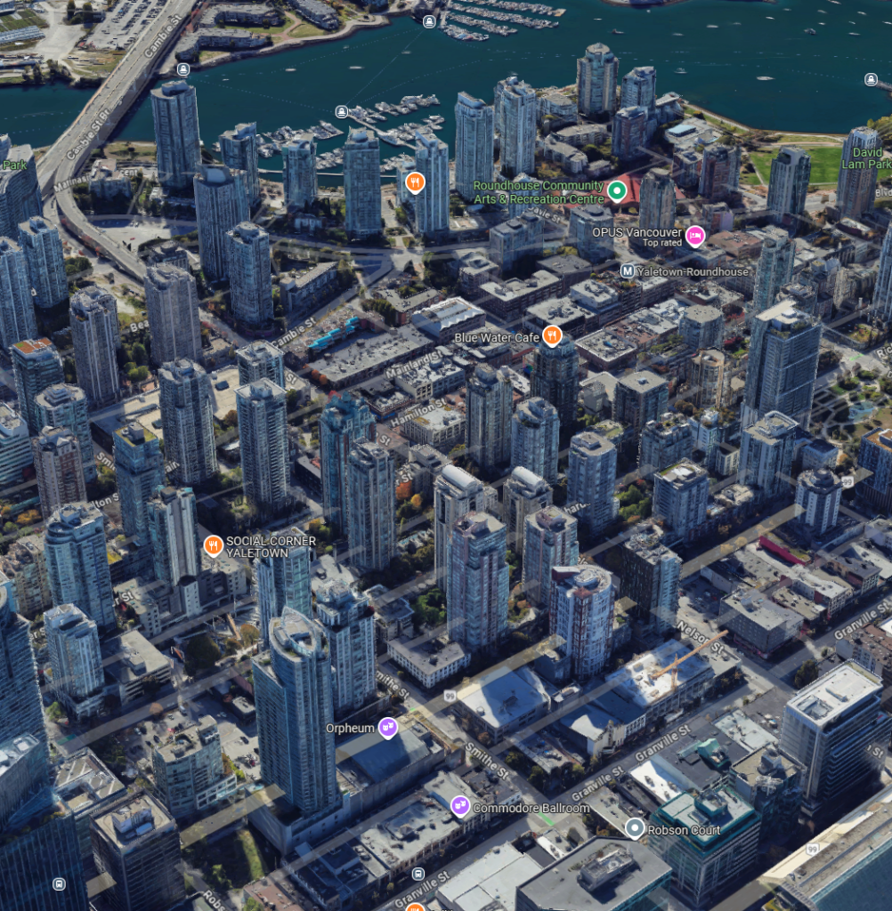
Tower over podium developments in Vancouver
When submitting the plan, Council planners fretted that unleashing more towers upon the slither of the city would create problems, and sought to solve these pre-emptively with a “slender tower over podium” strategy, an urban form where you have a full-block podium for the first 20 or 30 meters, and then a tower above.
This approach mandates a podium up to 28 metres, above which a tower must:
- Maximum Tower Dimension – a tower development’s floor plate should fit within a 50 meter diameter circle
- East-West Tower Dimension – a tower development’s floor plate should not be wider than 30 meters
- Tower Setbacks – a tower must be setback from the edge of the site by the greatest of 6 meters or 6% of the height of the building
While these may sound benign, the combined effect is highly restrictive. Warren and Mahoney’s analysis for Precinct Properties of these restrictions on behalf of Precinct which they presented during the IHP process. What they found is that there is less feasible tower development in the city core under PC78 than if they kept the controls from the Auckland Unitary Plan – leaving us very far from NPS-UD’s maximum density directive.
The setback requirement was identified in particular as a tower-killer: it effectively re-introduced height limits, and only made development feasible on larger sites.
More absurdly, Auckland Council’s own HQ wouldn’t comply with the 30m width rule. Nor would many prominent international towers often held up as design exemplars.
Thankfully, the IHP has walked back the Councils proposal somewhat:
- Maximum Tower Dimension – 50m -> 55m
- East-West Tower Dimension – 30m -> 45m
- Tower Setbacks – the greatest of 6m or 6% of the height of the building -> 6m
Planning Committee members should at least accept the IHP’s recommendations, but also ask, do we need these at all?
Auckland has urbanised happily without them, cities like Manhattan thrive with wall-to-wall thick towers, while other cities like Vancouver have been reviled for their strangely spaced towers.
Karanga-a-hape Station Precinct
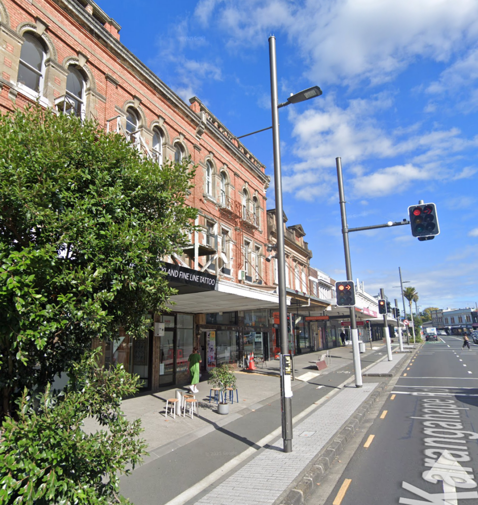
Old, unique brick buildings found at the Intersection of Karangahape and Howe
Possibly the worst missed opportunity (other than untouchables like E10) is the failure to leverage the $5bn investment we’re making in CRL.
This is acutely true for the Karanga-a-hape station area, where some of the city’s strictest height limits and least flexible heritage overlays remain intact — despite a $5 billion investment in underground rail.
Nowhere is the mismatch between planning and infrastructure clearer. A proposed 11-storey office building on a gravel pit near the station was recently declined for reasons including “height and bulk,” based on the Karangahape Historic Heritage Area controls — which PC78 leaves untouched.
Karangahape Road has genuine character in its built form, but more importantly it has vibrant character from the people who inhabit it. Making the area accessible to more people without a commensurate increase in the amount of housing, offices, shops, bars and clubs risks displacement and gentrification of the area – and it’s not worth protecting the built form of Karangahape if we cannot protect its people.
These controls go well beyond protecting genuinely historic buildings. They require new buildings to be “compatible” in style and scale, to “respect” the existing built form, and to avoid “dominance.” The effect is to freeze the character of the area in time, even as the world changes around it.
Instead, our historic heritage controls should be focusing on preserving the genuine heritage that exists but allowing new development – because our city will be more interesting and more prosperous from the contrast of new and old.
Conclusion
The Auckland City Centre should aspire to be a big, shining city on the Pacific, but nothing in this plan indicates we’re heading in that direction. Councillors should accept the IHP recommendations, but plan for Round Two.

 Processing...
This is so visionless. The IHP, like the council planners, are still in thrall of last century’s city-hating vibe. Making up word salads to bend reality that will prevent it thriving.
This is a tiny area, even just within the artificial constraint of the motorway noose is only 4.5 hectares, and yet they want to constraints it further.
We need more city not less. This is the most productive small patch of the country, by concentrating more here we take pressure off the beautiful and productive countryside at the edges. These are sprawl inducing arbitrary restrictions born of fear and prejudice.
Enabling cities to live their best life, to be more true to their internal economic and social logic of efficiency and concentration, is our best hope for dealing with the pernicious problems of the age: climate change and its effects, inequality of access and opportunity, and social dysfunction through isolation and separation.
No one is forced to live in the middle of them, but equally those who it suits shouldn’t be prevented from doing so either. These restrictions make development less likely, reduces choice and ensures what is build ids only at the higher cost end of the market.
As for the aesthetic pearl-clutching so evident here: The city is not in the way of the view: it is the view.
Gah.
“This is a tiny area, even just within the artificial constraint of the motorway noose is only 4.5 hectares, and yet they want to constraints it further.”
I think you mean square kilometres.
Yes indeed, quite right, is 4.3 square kilometres.
Apologies for the typos too- spat out over morning coffee!
The independent planners mostly seem to be a certain age and mindset, and work very hard to prevent future development. The rules should be focused on ‘you can do everything but this’ rather than ‘you can do this, this and this and nothing else’.
Re K Rd, it should be towers and neon lights, along with anything inside the motorway cordon of the CBD. Similarly Mt Eden should be closer to Britomart and Aotea stations in terms of development rather than the more suburban stations.
Newmarket however I’m fine with the density not being massively increased yet, because KR is going to have to come in with bulldozers at some point soon to turn the junction into a flying one/future proof it for the next 100+ years and fix the station. All of which threading through more towers would make it more difficult than it already is going to be.
Re heritage, I think it should be based on specific buildings and nothing more, as these overlays are just used as an excuse to stop density.
PC78 is essentially dead. The Council staff are masters at holding off central government changes. This time they just delayed and delayed hoping everyone would lose interest. The recommendations from the panel just mirror what the Council or Panuku asked for. So why bother wasting everyone’s time and money submitting?
AT should learn the delay tactics from Council for their speed increases.
Great post.
Also really sad that ACC aren’t strongly encouraging high density in other rail-mode suburbs. Manukau’s density was essentially set in motion under Sir Barry Curtis. And fully agree re the Wider Economic Benefit loss from CRL.
When the first section of CRL was done up to the District Court, nearly all land parcels changed hands and were turned into massive multi-storey developments. Anyone remember the CBD in 2018? It was one big building site.
It amazes me that state agencies could do something as massive as Hobsonville or the Avondale rebuild but not integrate the same ambition around rail nodes.
Sorry it’s Auckland Council not ACC apologies.
Vancouver’s oddly spaced podium towers are a function of a “80 foot” separation rule for any part of the building that exceeds 70 foot in height..
– This has been ascribed to ensuring sunlight between the buildings,
Although the unofficial history is that a long past town planner determined that this was the minimum distance needed to ensure you could safely stand naked in an apartment and not bring undue attention to yourself (This is Vancouver)
Stepping back, I do find it odd that we are looking to Vancouver for land use policies, given it has some of the most expensive housing in the world.
I think that reveals something about the preferences of planners at Auckland Council.
Vancouver is a planners dream. The desperate shortage and high demand creates endless opportunities for planning work and experimentation.
I can’t emphasise how shoddy the Council analysis is.
To prove that their Provisions enabled “as much development capacity as possible…” they have assumed that you could just demolish every single building in the city centre and start again, maximising floor area in a new theoretical building envelope. Fun examples included an assumption of a 27 storey office tower replacing the heritage listed St Patrick’s Cathedral, a new office tower on the heritage listed High Court, and an additional building with more floor space than the Commercial Bay Building on the Commercial Bay site itself. The results were so hypothetical as to be absurd/ impossible to realise. Each of these examples was explained to the IHP.
I would like to see residential apartments increase up to 50% providing the footprint reduces to reflect this change thereby providing a small amount of land for garden, or outdoor activities.
Ockham founder, Mark Todd, had some interesting views about regulatory issues currently holding back quality apartment building construction.
I don’t agree with all of what he said, however it seems pretty clear we have managed to cock up our growth settings by listening to the wrong interests (interestingly, not entirely NIMBYs but primarily the construction and property speculating industries).
I’d be very interested in a link to Mark Todd’s thoughts on the matter. I’ve always had an inkling that a weakness in YIMBY politics is giving the construction industry too easy a ride
Here you go:
https://www.oneroof.co.nz/news/apartment-boss-effing-rage-how-planning-rules-stuffed-new-zealands-housing-market-47574
Daphne, they might be referring to the interview he did with OneRoof a day or so ago if you google his name it should show up. I think he makes some good points, but of course one has to remember he has an angle too, being an apartment property developer.
Whoops, too slow – beat by Rob!
I (blithely) didn’t realise I could simply post that link, sorry.
Of particular interest is his strong views against the MDRS standards.
When driving around parts of Auckland where these new ‘townhouses’ feature prominently (particularly West Auckland); it’s hard to take the view that these standards are the unmitigated success that many articles on this hold them up as.
They have been a success in that they’ve been built, but without any guiding framework most developers have been more than happy to view the land use in isolation and purely with respect to return on investment which means no consideration for the surrounding area, common amenities, etc. This is not universally the case, but as you note in some areas the infill doesn’t paint the picture of success that people might be imagining. It’s a real shame and I view some of these infill sites are squandered opportunity.
An endless repeat of 5 or 6 sausage McMansions with just one cat-swinging space at their sunny backs and only a shared driveway at the shady fronts with no space to turn or park without using a private garage, hanging off successive vehicle crossings on arterial roads. these are always approved, even if it means visitors or delivery trucks reversing onto the arterial. Success for developers and banks, not so much for residents.
Success for
Streetguy, even if we took that as true (I don’t) it is still undeniably a better situation than the status quo, of no additional houses delivered.
As always the solution is simply to allow something better to be (economically) built. Which AC are desperately trying to avoid.
He did few interviews including one for The Post talking about putting a higher rate for underdeveloped land
https://archive.is/20250519172328/https://www.thepost.co.nz/business/360686704/owners-low-rise-buildings-around-transport-hubs-need-be-rated-out-ownership
Our NZSA group visited Precinct properties last week and the CEO told us that the university is short of several thousand rooms to accommodate students. I hope our city supports the university as it is very important to our economy and culture.
We are creating a city centre of giant toilet brushes in their holders; an arbitrary height to the podium and a ‘slender’ tower – why? We confuse the need for daylight in public space with sunlight. If you’ve been to Aotea Square or Freyberg Place (or any other public space) in the summer you’ll see that people seek out the edges of the space where it is shaded or under the trees. Sunlight can be harmful and designing a building to perform gymnastics to maintain sunlight into a very large public space only makes the building worse. We consistently sacrifice quality for ease of planning rules and we are worse off for it. The Urban Room hosted the model of the city centre from the 1960s-1980s. It showed many towers proposed but not built. Had a few of them been realised our city centre and planning rules would have been very different. Auckland needs a much better debate about what a quality city looks like.
In winter however sunlight, not just daylight is very very much wanted, as it is at the beginning and the end of the day.
Sunlight to the city centre’s public open spaces during times of greatest use throughout the year. Sunlight gives pleasure to visitors and provides valuable health and well-being benefits for workers and most importantly, the large number of residents living in the city centre. Furthermore, plants, trees and turf require minimum year round solar access levels to thrive in our open spaces, helping to reduce the impact of climate change and heat Island effects (e.g.trees for shade, biodiversity). The planning controls were carefully crafted in the 1980s to optimize sunlight at times of greatest use while still enabling substantial levels of development on the periphery – such as The Metropolis building which is adjacent to two public open spaces. These controls are sacrosanct and have never been successfully challenged which is testimony to their value to Aucklanders. A mid-winter lunchtime visit to Wellington’s Midland Park on Lambton Quay, cast in deep cold shadows of tall buildings and devoid of people, is a salient reminder of why protecting sunlight to public spaces must be a priority for urban densification in Auckland.
Excuse my ignorance, will this process include any changes to density around transit stations (I have a personal vendetta against Kingsland having basically no density) or is that still to come?
Still to come, but it is stuck in a bureaucratic nightmare of Auckland Council’s making and central government’s flip flopping.
I always liked the Waitakere City approach to height limits in their pre-supercity district plan. There were no explicit height limits in town centres, just the regressions planes for sun light applied from the boundaries of residential properties.
So if your commercial/industrial property was at the edge of the town centre close to the adjacent residential areas you were height limited to roughly the same height as the distance you were away from the residential area. But once you were in the middle of a town centre the regression plane was so high that project economics was likely to be the limiting factor.
“Ah, but…” a creative planner would look at that and say “…nowadays, our progressive zoning rules allows residential in mixed use zones, so really, pretty much everything is residential now!”
I recently walked up the city from Britomart to K road and took a turn onto Greys Avenue on my way there.
It became apparent to me that so many of these apartment/office towers have no (or very little) street frontages or active edges. Many of them had driveways to underground car parks, Ramps to the front door and solid block walls facing the street.
There are a few shops here and there but very few generally speaking.
Upon further walks around the city, I’ve noticed just how many of our city centre buildings serve very one dimensional purposes, and offer very little to the street below it.
As a younger reader (24) I can only assume that many of these towers were built in a boom where glass and concrete were the be all and end all, and everyone drove everywhere.
I would hate to imagine what old grand buildings were demolished to make way without consideration for what the building offers the street.
That mid-town block around Myers Park; Greys Ave, Vincent St, Mayoral Dr is littered with tall towers that are actually isolated from the street below.
Whatever changes are made to planning regulations, I can only hope that we make the buildings interact with the street, which hopefully could bring back much needed life to the city.
No need to imagine it was documented at the time Matt did post on here about it, I can’t remember the title of it so can’t link to it.
But can link to the Kaleidoscope episode
https://www.nzonscreen.com/title/kaleidoscope-town-planning-1985
That was a really great TV series. Mrs mfwic had Heath Lees as a lecturer and I would bunk off engineering to sit with her. He taught in one of the old houses in Princes Street and he would sit at a piano and illustrate the points he was making by playing tunes. It was an hour of entertainment where you also learnt something.
Funny my Grandmother knew Verne Warren. Certainty some characters on that episode and old Broomhead lived so long he was still somewhat of a public figure in my lifetime. Interesting how the movers and shakers got swept aside so quickly
Vern was the boss of the Planning Department when I was there. He was appointed to get more consents through and he achieved that. The people who didn’t like development in that episode got their way and slowly but surely more rules came in and an Urban Design Panel to add cost and delay to every project. The result was the money went elsewhere.
I am glad for just a few weeks to be out of Auckland where the attitude to urban change seems to be either, we can’t, or we won’t. Refreshingly every city or town that we have visited has a pedestrianised area. Shopping has never been a priority for me, but it’s great to be able to stroll around in safety, unlike the abominations that we called shared streets. If any car driver accepts that they have to share the street, it sure as hell isn’t an even share. (Of course I should acknowledge Auckland’s pedestrianised area – Albert Park.)
We have arrived in Bologna, a city of about 800,000 people and I have discovered another SUMP project (Sustainable Urban Mobility Plan). For Bologna that is 4 new tram lines stretching over 57kms, with the first two being built simultaneously. Significant parts of the city are under construction.
It still seems incomprehensible that the Dominion Road project was canned. Only in Auckland does it seem that significant portions have to run underground; that the line needs expensive stations; that those stations are so spaced that they discourage walk up traffic; and that we have little disposition to build higher than three storeys around our public transport corridors.
Patrick. I share your frustration about all the issues that you have raised regarding our current city form. Unfortunately I think the worst is that the current model is economically sub-optimal, that the benefits of scale cannot be achieved by far flung suburban developments.
Te Komititanga is properly pedestrianised, and works brilliantly. Brilliantly and instantly, no one needed telling what to do.
Right location, right form.
Yeah Bologna, and Florence, when I lived there it had no trams, it has two lines now and two more on the way, these cities keep improving, maybe they have no ‘special character’?!
With issue of water and wastewater constraints you know the areas that still have capacity for growth that’s right the central city and inner central
https://www.rnz.co.nz/news/national/561275/demand-increasing-for-land-unaffected-by-auckland-s-water-infrastructure-constraints
Possible K Road reprieve for one building/block but what a waste of everyone’s time and money. And given the rest of the restrictions are set to remain we are so cooked.
And how can someone like this actually be in charge of something?
Alex Bonham saying too much glass and “not enough parking” next to the CRL station – is this real life?
https://businessdesk.co.nz/article/property/james-kirkpatricks-k-rd-development-may-get-reprieve
Ah hello there, the problem is real, 73,000 parking infringements in Ponsonby area last year (Newmarket in contrast is just over 10k). Servicing and loading kerbside can also be tricky where there is very little parking space. My role on the local board is to raise issues so they can be addressed. The planners recommend a traffic demand plan for the landlord to work through with tenants, which seemed a good solution. Yes, the building is 8 minutes walk from the station, it is also one minute from the motorway on-ramp. I would love 95% of staff to get there by bike or bus, but that needs some thinking through on how it is to be achieved.
Did they vote?
Yes
https://infocouncil.aucklandcouncil.govt.nz/Open/2025/05/20250522_PEPCC_MIN_13501_EXTRA.PDF
I’m surprised to see Vancouver referred to as “reviled” since it’s pretty widely praised as one of the best-developed cities, including by experts like Jan Gehl. It’s a place that feels densely built while also not feeling like a windswept sunless canyon. Alas…
I feel like the area around K road can be developed while keeping the character of the streetfront. There don’t need to be towers on the main strip or anything, here’s plenty of space just off of it that can be built up and not affect the pedestrian experience. The Church-Wellesley Village in Toronto is being developed like that.
one thing i’ve found stupid about uptown akl is the amount of space taken up by the water reservoirs on the newton ridge. surely there’s a way to replace them, say, move them underground and free up some significant square meterage for inner-city development?
They are located above ground on the ridge as part of the system that maintains water pressure, moving them lower would reduce the pressure head and require extra pumps running around the clock etc. That would affect the ability to fight fires during a major emergency, among other things.