Auckland has a long history of transport mistakes, and one of the major recent ones (as outlined by Darren Davis here) was to not build a Northwest busway at the same time as rebuilding most of the Northwestern motorway a decade ago.
One of the few areas where Greater Aucklnad is in strong agreement with the government is the need for rapid transit to the Northwest. Because, while the interim bus improvements that finally went live last November have helped – and Auckland Transport report that usage is already exceeding expectations by around 50% – there’s still a lot of improvement needed and that can only come with a proper rapid transit route.
In July, Transport Minister Simeon Brown confirmed the next steps for this were underway.
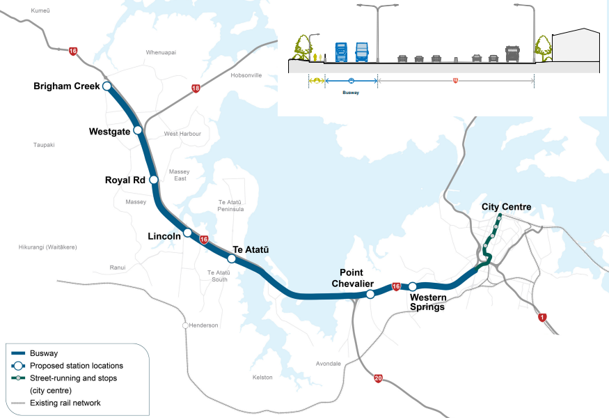
Transport Minister Simeon Brown has welcomed progress on Northwest Rapid Transit, as the NZ Transport Agency (NZTA) confirms next steps on the preferred option, a busway alongside State Highway 16 from Brigham Creek to Auckland City Centre.
“The Government is committed to a rapid transit system that will support urban development, housing growth, and provide commuters with real choice in how they get around our biggest city. That is why Northwest Rapid Transit was recently designated as a priority in the recently released Government Policy Statement on land transport,” Mr Brown says.
“With more than 100,000 extra people expected to be living in the northwest of Auckland by 2051, we need to provide more reliable public transport choices that reduce travel times, congestion, and emissions in Auckland.
“The preferred option for a busway includes a proposed park and ride station at Brigham Creek, with stations in the west including at Westgate, Royal Road, Lincoln Road and Te Atatū. There will be further connections heading into the city centre where people will be able to seamlessly connect with the wider transport network.
The Minister also said that Waka Kotahi/ NZTA would soon be speaking more about the preferred option. This is now about to happen, with the agency set to hold a number of community sessions.
We are holding community information sessions over the next few weeks to talk through the investigations into rapid transit along the Northwestern Motorway, State Highway 16, from Brigham Creek to the city centre.
The events will be opportunity to meet the project team, learn more about our investigations, ask any questions you have and tell us what’s important to you.
Venue Date / time St Lukes Westfield Mall
Wednesday 28 August (11am – 2pm)
Thursday 29 August (4pm – 7pm)
Friday 30 August (4pm-7pm)
Saturday 31 August (10am – 1pm)Pt Chev Woolworths (Town Centre) Wednesday 4 September (3pm-5pm) Henderson Night Markets Thursday 5 September (5pm-8pm) Catalina Farmers Market Saturday 7 September (8.30am-12.30pm) Avondale Markets Sunday 8 September (8am-12pm) North West Mall Tuesday 10 September (12pm-3pm)
Wednesday 11 September (12pm-3pm)
Thursday 12 September (4pm-7pm)
Saturday 14 September (10am-2pm)Te Atatū Peninsula Community Centre Wednesday 18 September (10am – 1pm)
They’ve also released this new video of the project
This graphic in the video is interesting: it’s not clear if this is just a generic illustration, or a proposed Lincoln Rd station?
Westgate Station
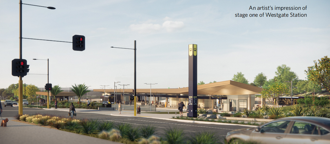
The first step for the busway is the Westgate Bus Station which was meant to be part of the interim improvements project. Waka Kotahi has taken over the project from Auckland Transport, and it is now meant to start construction early next year and be completed in mid-2026. There’s not a lot of detail about the design other than the new image below.
It does seem the design has changed from the AT version, though. The AT design in the video below showed the station making more use of Gunton Dr for stops, whereas the image above seems to be more of an off-line station (though still with at-grade crossings). That probably aligns more with the long term plans to eventually extend the busway all the way to Kumeu.
There are a couple of other things about this project and the current plans that I’ve been thinking about a bit recently.
Additional Stations
On any public transport route, there is always a balance between how many stops/stations you build to provide access to the services and the impact that has on the speed of the services. I think there’s potential for a couple more stations to boost ridership without causing too much impact on overall travel times, especially as current planning rules allow for more housing around stations. At the very least, it would be good to see these locations investigated:
Westgate South
The new Westgate Station as proposed will be useful, but much like Albany, it is in an isolated location, away from much of the local housing and commercial activity. In Westgate itself, the older and newer commercial areas are also separated by very hostile stroad of Fred Taylor Dr. Even if we assume a busway will also see an extension of the NW cycleway, this still puts the older commercial area mostly outside of comfortable walking distance. Also outside of that walking distance is pretty much any existing residential area.
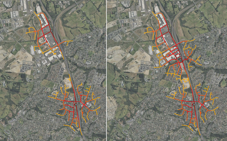
I suggest a Westgate South station would both solve this issue and greatly increase the walk-up catchment (while the currently planned station could continue to be the interchange destination for local bus routes).
The maps below show the 800m walking catchment with and without a potential Westgate South station, potentially located just in behind the Woolworths.
Huruhuru Rd
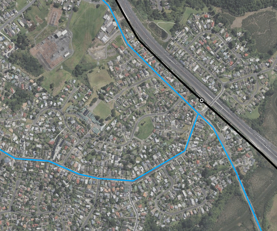
I haven’t made a map for this one, but a similar issue exists between Royal Rd and Lincoln Rd where there’s a residential pocket that with redevelopment, could led to a decent population of walk-up ridership. The two branches of the 11 bus route (11T and 11W) do combine here and go through to Lincoln Rd and the city, but Triangle Rd can also be quite congested – so a local station would be much more attractive. The big issue here is likely to be that there’s just not that much land north of the motorway that’s able to be redeveloped.
Bond St
One thing notably missing from the route map shared at the top of this post is a station closer to the city, somewhere around Bond St. This is something that has been on earlier plans, such as the business case from 2017:
Staging and the planned busway extension
The big question now is how this busway will be staged. The previous business case suggested building the first section of busway between Lincoln and Te Atatu. However, with the interim bus improvements in place, perhaps the focus should be on other areas, like Westgate to Lincoln, seeing as it would also add at least one new station (or more, based on my suggestions above).
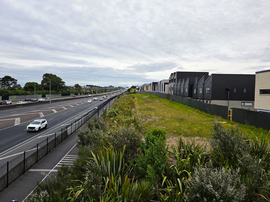
Notably, the section just south of Westgate is the only one where land has been reserved for a rapid transit corridor – I believe this was due to Auckland Transport stepping in, as otherwise the developer had planned to build those houses right up to the motorway boundary.
Work has also been underway on planning and securing land for the busway to extend to Huapai/Kumeu, with Notices of Requirement lodged for them a few months ago. Given there is significant traffic on SH16 between Kumeu and Brigham Creek, building this section early could be key for giving those residents a realistic alternative.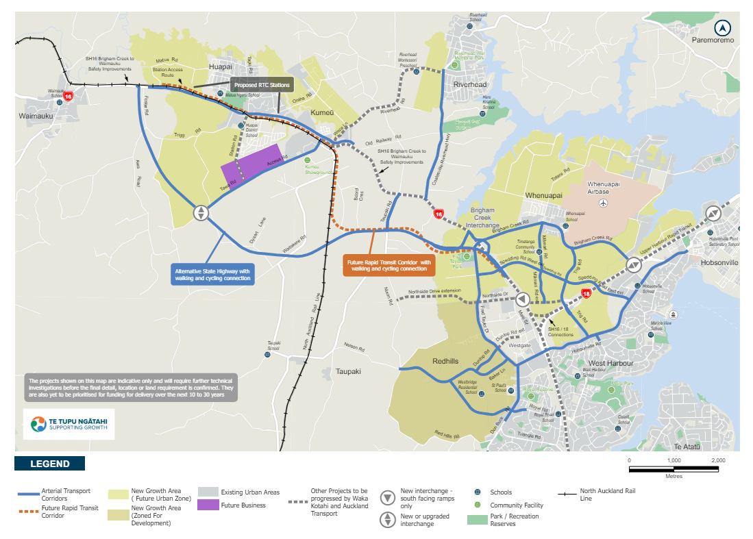
Interestingly, the business case for that section suggests the busway be built before the motorway is extended:
The City Centre Conundrum
One of the hardest pieces of the puzzle is what to do when these rapid-transit buses arrive at the city centre. For the Northern Busway, this is fairly easy as they emerge from the motorway onto Fanshawe St – but for the Northwestern, it will mean navigating though a lot more local streets and intersections.
The maps released so far seem to suggest buses would follow Ian McKinnon Dr to Upper Queen St, then travel along Karangahape Rd and down Pitt St, and then though to Albert St. I’ve got a few concerns with that, including:
- While light rail is dormant for now, the spatial realities of city-centre access will likely mean it will come back again in the future – and Ian McKinnon Dr is likely to be needed for that access.
- Sending a rapid transit route through the Pitt St to Queen St section of Karangahape Rd seems far from ideal. Even just sending buses down Queen St and then around Mayoral Dr to Albert St seems like it would provide a better, more reliable outcome.
Waka Kotahi say there’s a new business case to come – and, if approved, a lot of design work still to do – but the current plan is for the first stages of the busway itself to start construction in 2027. I wouldn’t hold my breath for it, though.
Hey there, and thank you for reading! If you value this post – and Matt’s tireless attention to proactive transport solutions for our city – you can always support Greater Auckland’s work with a one-off or recurring donation to keep the kaupapa rolling. Thanks to our donors and subscribers for making posts like this possible!



 Processing...
So soon it will be quicker to get from Hobsonville to the city than from Sandringham / Mt Roskill / Hillsborough / Lynfield / Blockhouse Bay / etc. Between Auckland council’s zoning rules and the governments transport priorities, there seems to be no incentive at all for a more compact city, just endless sprawl.
Yeah it is completely ridiculous. Yes great that there might be a NW Busway but these suburbs are so far from the city. Just look at those aerial photos, there’s barely anyone living there.
Sprawl sucks
“So soon it will be quicker to get from Hobsonville to the city”
Soon? I wish I had your confidence that the stuff described here will actually happen in the next decade. It hasn’t been talked about as long as improving Dom Road, true, but it’s been about 20+ years for this one too, already.
Things are a lot more concrete and moving forward now. Personally, I would of gone straight to a lightrail or metro solution but …
I guess if its swamped relatively early on it will be trackless trams or a LR/LM solution. But that will prove the point for future corridors to go straight to the latter. Otherwise, Northern Busway services, with a better solution once in the CBD, will be more than suitable.
Bus priority (24/7 lanes, busways on major corridors) are our immediate future and that’s perfectly fine. After 2030, Kiwirail can chip in with Avondale-Southdown HR, lol.
Hobsonville is part of the city. There’s no sprawl going on there. It’s already been built. Some bits of Hobsonville are the very model of what compact development should look like.
If you want to look at ‘sprawl’ the watershed is now somewhere between Huapai and Helensville. Anything between Huapai and the Sky Tower is basically just infill now. The city is is already that big and has been for some time. The fact we’re only just adding the PT bits in we should have had here the whole time doesn’t change that.
when the 252 and 253 are running the journey into the city from Roskill South is less than half an hour. Unfortunately the 25L and 25B gets sent off on a wild goose chase down suburban streets.
Sounds like it’s going to be 20 min from Westgate to K Rd, then another 20 min from there to Britomart.
Some of these routes should be designed to run straight to the city via the port motorway exit to Beach Rd. Perhaps every second or third bus could do this.
Run them all via port motorway then Wellesley street?
That would seem the most logical given that by the time it opens the CRL will be running and it would be easy to catch a train to K Rd or Britomart.
Yes, run light rail/metro instead to Wellesley St, big uni catchment there & it’s the city ctr. Keeps it out of the way of slow streets leaving K’rd etc for other buses that are still likely needed to be interlaced with a metro.
Why can’t there be 24×7 buslanes along Great North Road with bus signal priority, less stops, close K Road to cars and make it a transit mall then down a Queen Street transit mall? We talk about doing this for Dominion Road etc but on an even easier route we are talking about just sticking to the motorway. Then all you need to do is convert it to Light Rail and connect it to the North Shore
https://www.rnz.co.nz/news/national/526228/hundreds-of-new-homes-in-massey-not-connected-to-sewerage.
Sprawl sucks literally.
“Just open up more land”
Nearly 2030 and our biggest transport project will be another bus way along a motorway that should have been done as default 20 years before that. Classic Auckland.
And given the lead-up time (no spade in the ground till 2027, completion around 2030?) we need to start the planning on our next RT corridor.
I don’t know the timeline on Airport to Botany but am guessing it will finish just after the NW starts. The same should happen for something like Avondale-Southdown/Onehunga; should be kicking off just as NW finishes.
It’s that mythical infrastructure pipeline everyone is talking about at the moment.
Had AT proposed this as the first light rail line they might have got it off the ground. Instead they proposed light rail and a very expensive replacement for some buses on Dominion Rd, as if that were needed.
Can someone please show miffy the abundance of twitter images of crowded and jammed-up buses on Dominion Rd and Mt Eden Rd stretching back to the mid-2010s?
I’ll accept staging, ambition, and political will as an argument that NW light rail should have been put forward first but the idea that buses are sufficient to cope with current demand on the Isthmus has a lot of evidence against it, and that’s not even getting into the impacts of the intensification that should be happening in the villa belt.
A queue stretching back to the mid 2010s sounds even worse than that shopping centre in Newmarket. I hope the Council is providing toilets.
It was all going well until someone mentioned “AiRPort”.
Reminds me of that interview with the city rail link boss mentioning we should have a ‘pipeline’ of such projects. Imagine the line on Dominion Road was actually started back then, it may have been finished by now and the extension to Mangere or the line to Westgate may have been under construction by now.
None of this makes much sense if AT cannot get it head around implementing effective bus priority on Te Atatu Road, Lincoln Road and Hobsonville Road to feed the current “pop-up busway” or the longer-term busway. Experienced the joy of a connective journey via Lincoln Interchange last week rocketed up the northwestern at 2pm, then spend 30 minutes waiting for a 14 at Lincoln Interchange due to the gridlock on Lincoln Road and around the interchange. Not impressed. I pity those who have to endure this on a daily basis.
Exactly this. The slowest part of the 110 is along triangle Rd.
My guess is you wouldn’t need to go along Triangle Road, you’d get off/on at Royal Road and catch a connecting service from there.
The experience from the Shore seems to be the connecting services are almost as important as the busway itself, so perhaps you could run Massey-specific loops from the Royal Road stop and then back along Huruhuru to link up with Don Buck Road? You would need to sort out the roundabout at Red Hills which is already overwhelmed by traffic heading out to the new developments.
You have to use the 110 from Royal Rd or else you need to catch the 111 which takes you back to Westgate to then catch the express bus. Roll on the expanded bus way so we get a stop on Royal Rd. You are right to say the connecting bus service is just as important as the busway itself.
Westgate South Station idea should be called Massey for starters. Yes, good connecting buses are important.
Very much so and without bus priority for the connector services people will keep driving cars because that is what is still prioritised. So many people on local FB are asking that busways come with huge Park N Rides since they have never been able to experience a system that actually makes PT work well.
Yes I hear this all the time. I try to tell them you will just clog up the access roads with cars but they don’t get it. We have to start charging the true cost of park and ride but also make priority for connector buses so that they are quicker than the car and then people might finally get it.
Just send them to Albany and they can see for themselves how it turns out
While the surface light rail into city has been pushed back by the cock-up of the Labour government, progressing the Northwest busway should hopefully highlight the main need of light rail – address the bus congestion into the city.
Anyone else notice the trackless tram?
Looks to me like a Van Hool Exquicity, like the one used in the Airport to Botany rapid transit animation
Also interesting to note the Kumeu Station concept art includes a very wide railway platform and electrification? An actual firm plan, or something to get the ‘heavy rail or bust’ dogmatists on board?
We should be looking for RT network connectivity gains where we can get them. Some sort of integrated transit hub there should at least be future proofed.
We’re too late — Van Hool went bust.
The Westgate South bit is interesting. There was also likewise a similar buffer at the bottom of Triangle Road but that has now been infilled by housing.
I wonder to what extent the AT/Westgate Development dispute disrupted plans for a better integrated corridor and what we could have had (years ago, mind you) if that had actually gone ahead.
A Westgate South station should be a no-brainer; maybe the old Westgate big box shops can be redeveloped as a more residential-mixed use ToD befitting a metropolitan centre.
I remember the 2014 NW busway concept indicated a third potential station at Mawera St? But it seems like the catchment and development opportunity for that area right up against the Waikumete are limited
Genuine question – is there any opportunity to reallocate motorway lane space to develop a busway?
Not without making sure the busway doesn’t get built for another 20 years.
Looks like all the imagery has a 3 lane each way motorway – so maybe some of the 4 and 5 lane wide sections of the inner North West will be reallocated.
Although I doubt it.
Well yes really, because there are already 2 lanes for buses for the most part anyway. you just shift the centre median either way. But NZTA have this obsession with providing an emergency shoulder, despite many sections of the motorway having none anyway, and coping fine.
Hell, you could even kill off some general lanes if you really wanted to, there were plenty extra added in only 2015, and it hasn’t really helped the congestion situation anyway, you just push everything closer to the city but make zero change to journey time. But NZTA don’t understand transport science and are ideologically attached to faulty concepts like more lanes and flow.
Yes that would make it a lot easier and cheaper to build bus or metro. Gets some mode shift happening. During construction you could allow the current buses to use a general lane in effect perhaps in peak direction only.
The thoughts above about using Wellesley st are interesting as it’s quite a squeeze of roads under Upper Queen St including long on/off ramps. There is probably not the case to take lanes here so easily so I wonder if quick up and over or tunnel under to avoid this. But “ca-ching, ca-ching” $$. Over sounds cheaper and gives a better lookout and wouldn’t be that hard surely if you ran an elevated centre running system closer to the city end.
The construction pipeline looks more like a garden hose with kinks in it. It was the last National government that missed the bus with the NW. Let’s hope they can plan an express delivery now. It took us frantic effort to protect even a little space for the future RTN up near Westgate. NZTA let go the land reserved for Lincoln and Te Atatu interchanges, so space has to be found from scratch.
SGA has now lodged NoRs to protect for future RTN, but the funding for it is still needed. Auckland to Mangere is still in dreamland, with ALR cancelled. Do-minimum Road still awaits….
The city portions really need serious thought, with Pitt St choke point and a slow slog through the centre. Queen St or Grafton Gully-Wellesley St as alternatives? That will come later in development, so the NW end needs focus first.
I wonder if people from Kumeu, Huapai or Riverhead will be able to get to any of the planned info sessions?
After many minutes of contemplation, I have an idea for the city side of the connection. End the busway attached to the Northwestern Motorway in Kingsland at Central Road next to Nixon Park (which would have bus lanes). Buses would cross New North Road to an area reminiscent of Lower Albert St, where Edendale Rd currently is. This connects the Northwest busway to Kingsland Train Station.
Once City Rail Link is complete, this will connect the Northwest to the existing transport network by the EWL and OWL lines, with the option to transfer to SHL only two stops away.
I hope that by the time this project would be complete that our bus fleet will be all electric, minimising the noise pollution at Central Road.
I am not familiar with this area and would be very interested to see what you all think of this idea 🙂
What’s the distance from Brigham Creek to the edge of the CBD….20kms?
Interesting that Sydney just built their latest metro link – almost 16kms, tunnels, stations and all, in 7yrs. This is going to take half that time.
Happy if it happens. Obviously I’d prefer a light metro/REM like solution (preferably by the NZ Superfund etc), but as long as it goes to the CBD (or at least Mercury Lane if the CBD is too hard as easy transfer to CRL until capacity is eventually reached), has a stop at Western Springs (Motat, Zoo, 2 schools, 65, 18, 11T/W, 132, 195), Pt Chev Shops (Outer Link, 66, 1 school, 18, 65, 11T/W, 132, 195, Unitec, Unitec housing development), Te Atatu, Lincoln Rd, Westgate, and is future proofed to keep going westwards along SH16 I’m happy.
It’s a great route/corridor, with tons of links to great places and frequent feeder services. Only thing the route is missing is a UHEX express from Westgate to Constellation. 12 fulfils the local bus, but if you’re going from West to North or vice versa, you don’t want to go to the CBD or be stuck going through suburbia on the 12.
We need more stops in the outer west than the central west suburbs. No one will bother with a bus that still has to crawl through the bit of the journey that’s already slow – it’s a busway for West Auckland, after all, not the inner city bits that already have things like bus lanes on their main roads.
The city end of the NW Busway should go down Grafton Gully and onto Wellesley St, then onto Mayoral Drive (and perhaps back via Hobson St).
There is a whole empty lane (on the right side of the motorway) from Newton Road to the Symond St overbridge that they could use.
More evidence that our transport planners are clueless, treating PT projects as if they are just an extension of roading or motorway projects that try to get people from A to B.
Every PT station should be a PLACE and destination in itself. Hardly something achieved by PT stations being next to motorways which present a massive barrier to pedestrian accessibility and completely degrade the amenity surrounding the stations.
D grade at best.
Why?
Busway stations don’t have to be a place, they’re just an interchange to get to places
So what’s going to happen to the NW cycleway? Is it going to be between the motorway and bus lanes?