As I reported about the city centre, Auckland’s rail network is also going through a difficult and disruptive period which is rapidly approaching a culmination, which will result in a significant upgrade to the whole network. Hallelujah.
Also like the city centre, this is an upgrade predicated on the City Rail Link. Through 2025 and certainly by early/mid 2026 we should all be experiencing a hugely improved railway; much more reliable, with higher capacity, and potentially higher frequency. Maybe even an all-day turn-up-and-go Metro style urban system, though that depends on choices made about how to run and manage the competing services on the rebuilt network.
Both the CRL and the Pukekohe overhead wires are going live, with testing starting very soon. The inner core of all three main lines – New Lynn to Ōtāhuhu – is now all rebuilt, and should be functioning near faultlessly (once teething troubles are over). This is all getting very real.
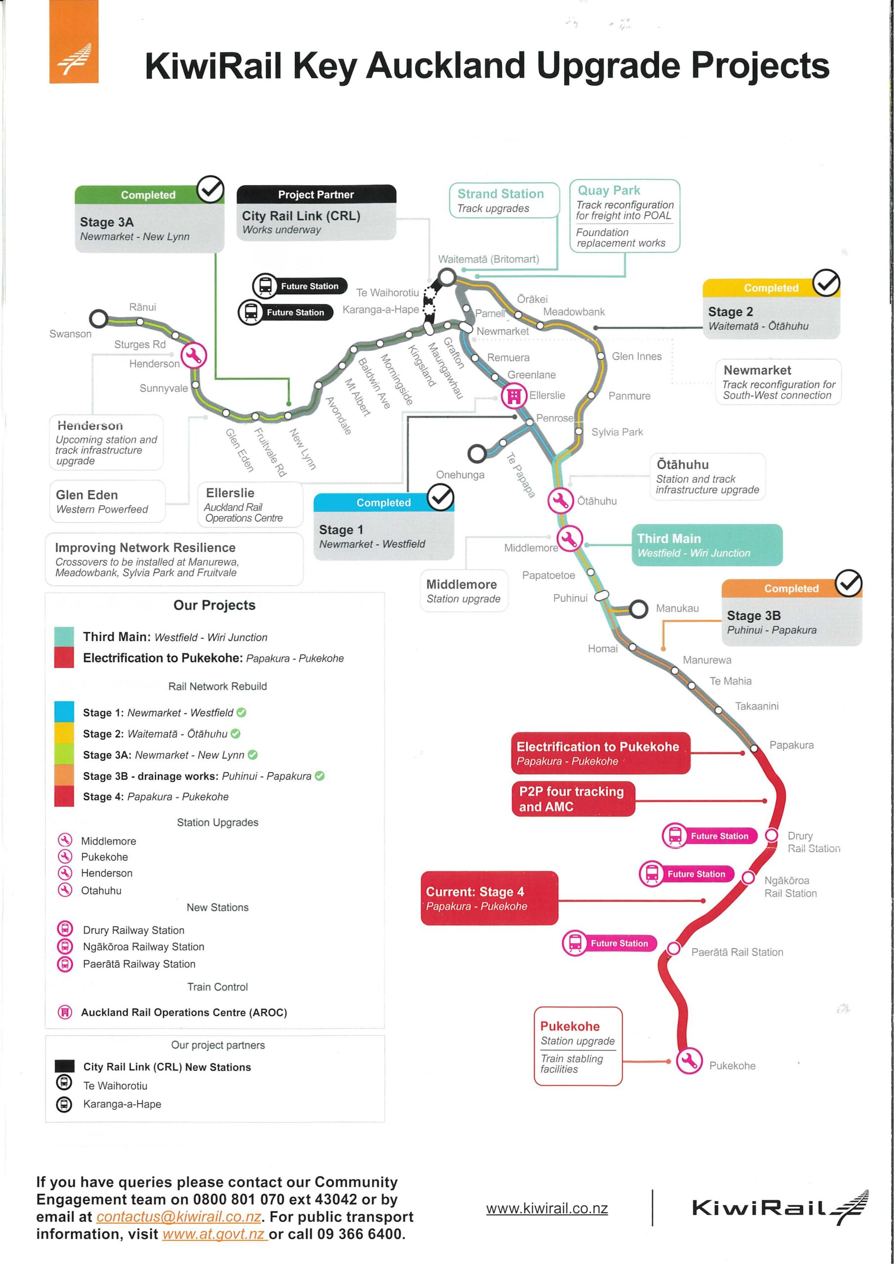
The Third Main, along the busiest section of track in the nation, is approaching completion at Middlemore, and while it is the shortest possible bit of meaningful duplication, its critical location means it will have very real positive impacts on all rail services. See the benefits below.

This section – from the Manukau City Branch line and Metro depot up to the Westfield Junction, where the Southern and Eastern lines meet, and with both Auckland freight depots, Metroport and Wiri, on its length – really needs be four tracks. This is where the Southern and Manukau City lines overlap, as well as all freighters and Intercity trains from the south. So it is very good to see Kiwi Rail pursuing designation for quad-tracking all the way from Pukekohe to the Westfield junction.
The next section, south of Wiri to Papakura, would also benefit hugely from getting a dedicated freight/ Intercity/ express track, or ideally two. This area is the subject of today’s post.
As these projects above are completed, investment is due to wind down for rail given the new government’s priorities are elsewhere, as we know. However, the RLTP includes one more major project:

Looking at this project as currently proposed, I feel it could productively be redesigned to align more with future rail plans, particularly extending the third main through here. There is time for consideration, as noted in the snippet above: this is to happen ‘in the outer years’ of the 10 year RLTP.
Let’s have a look.
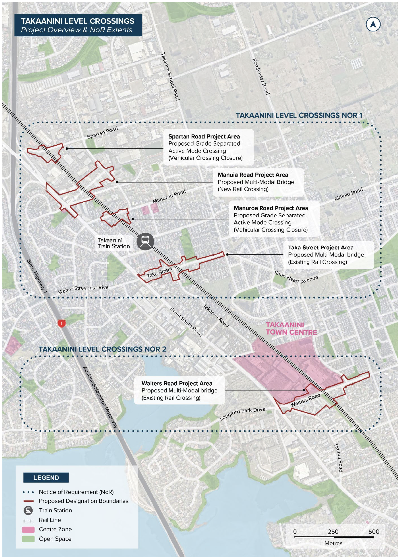
Level crossing removal [LXR] absolutely improves rail performance, but the primary benefit goes to road users who no longer have to give way to rail traffic that has priority.
In fact, the main way LXR improves rail performance is that it removes the artificial constraints imposed on rail traffic to not delay drivers so much, i.e. by having barrier arms down. There are other safety and crash reduction impacts on both road and rail networks, too.
But, as can be seen very clearly from the designation outlines above, currently this is imagined very much as a big roading project, with significant land take along roads. This land acquisition does not widen the rail corridor for additional track.
There is another significant impact that I feel we do not take into sufficient consideration in our usual processes: place quality outcomes. I will write more about this for the Western line LXR in the future, where there are really a lot of opportunities. But as this is the more urgent group of level crossings to remove, let’s start here.
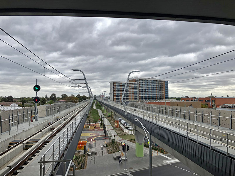
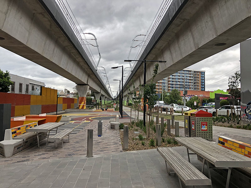
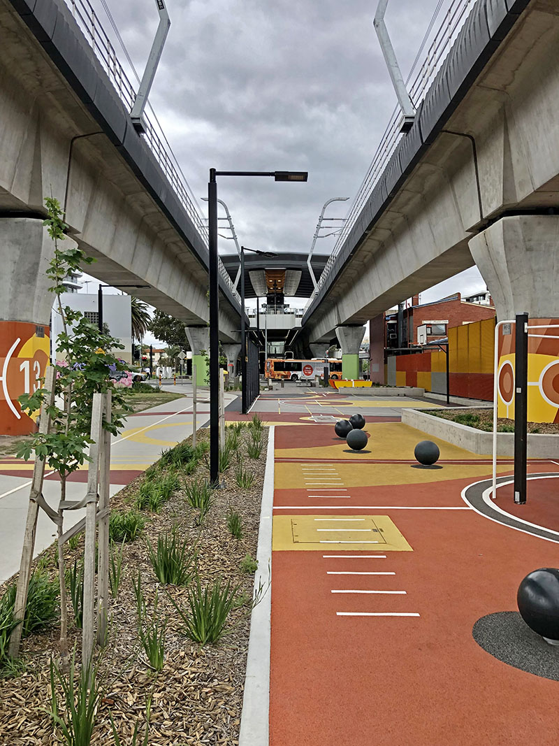
And let’s start with an example from a peer city. Melbourne is deep into a huge, and hugely successful, LXR programme. I have visited a number of these locations, and by far the most successful are when the rail line has been elevated over that mostly flat city.
This works so well in so many ways – not least for the rail passenger, as the view from the elevated trains and platforms are such an upgrade on being at ground level, let alone in a trench of tunnel. Elevation also allows for great bus and bike connections and creates public space under the stations on the contiguous ground plane. It heals the severance previously caused by long uninterrupted lengths of rail line, and allows a whole new public realm and connecting active mode paths.
Here’s a few shots I took on a nasty day in 2019 at the Carnegie Station on the Cranbourne-Packenham line:
Coming back to our city: the terrain is largely flat on this area of the North Island Main Trunk line (NIMT), and it would be great to free up space like this through South Auckland for local use. As described above this is a core line for freight and Intercity services, as well a Metro route, so it desperately needs to be quad tracked.
Building elevated structures for four tracks through here, plus stations, I assume would be prohibitively expensive. So the design calls for road-over.
Let’s look at the planned outcomes as assessed by the Supporting Growth Alliance:
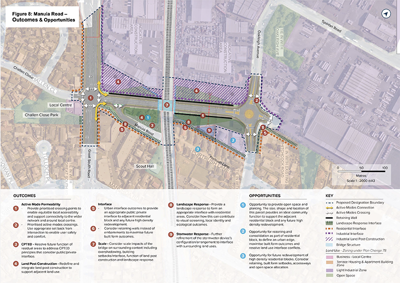
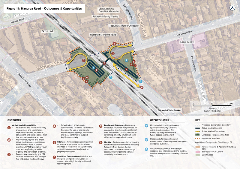
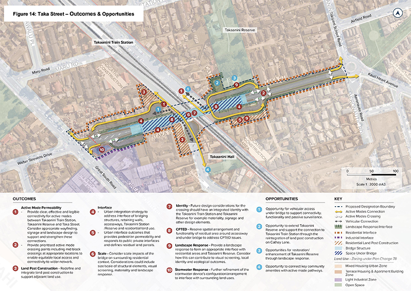
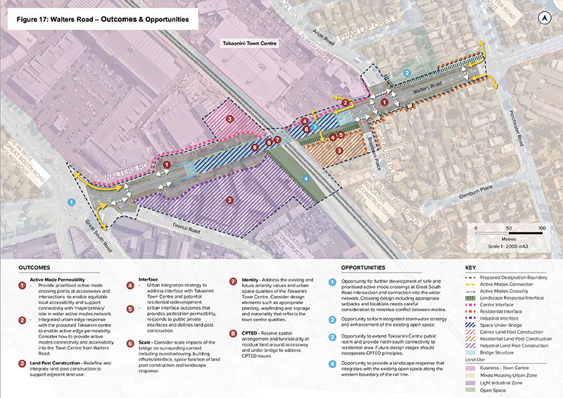
This is a big road project. Building these bridges to carry vehicles over the railway line involves taking a lot of land and buildings, and leaves a whole lot of either embankments or retaining walls, or even at-grade parallel access roads and nasty under-bridge spaces.
I note these are called out in the report as needing resolution of ‘CPTED issues’ – i.e., they will look and feel unsafe for people passing through the area, and that will require addressing.
A particular mystery is why Takaanini Station is not moved a little north or south so the overbridges can get double value as grade-separated platform access?
The Manuroa pedestrian overbridge would surely be more useful if it also offered access to the platform currently 124m away. Or perhaps it would be better to shift the station south, given it is more than 3.5km south to Papakura Station, but 1.6km north to Manuroa. (Ever since the closure of the Tironui station there is a big gap here, and this should be re-evaluated as housing grows in the area).
It certainly seems odd to grade-separate the roads but not the stations themselves – especially while building elevated structures. Why would you miss that opportunity? Though of course I know the answer to this, my old adversary; scope. Whoever controls the scope controls the project, and clearly station access grade-separation was not included in this road project.
For all the efforts of the authors of the urban design evaluation report, this whole approach looks ghastly, very land-hungry, and not inexpensive:
I wonder if there is an option to revisit other alternatives? Perhaps trenching the rail line – after all, piling a space wide enough for four tracks shouldn’t cost much more than for two.
And the process of discounting this option looks to have been fairly cursory. It appears to pretty much be the following MCA, without any detailed engineering analysis. Indeed, the DBC describes the rail trench as having ‘perhaps the best outcomes in terms of visual effects’. Here’s the documented process:
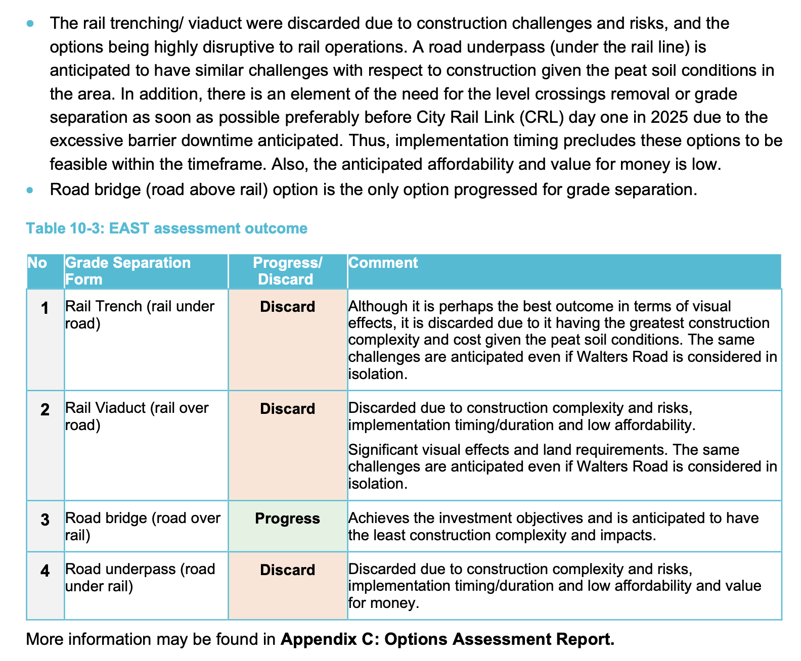
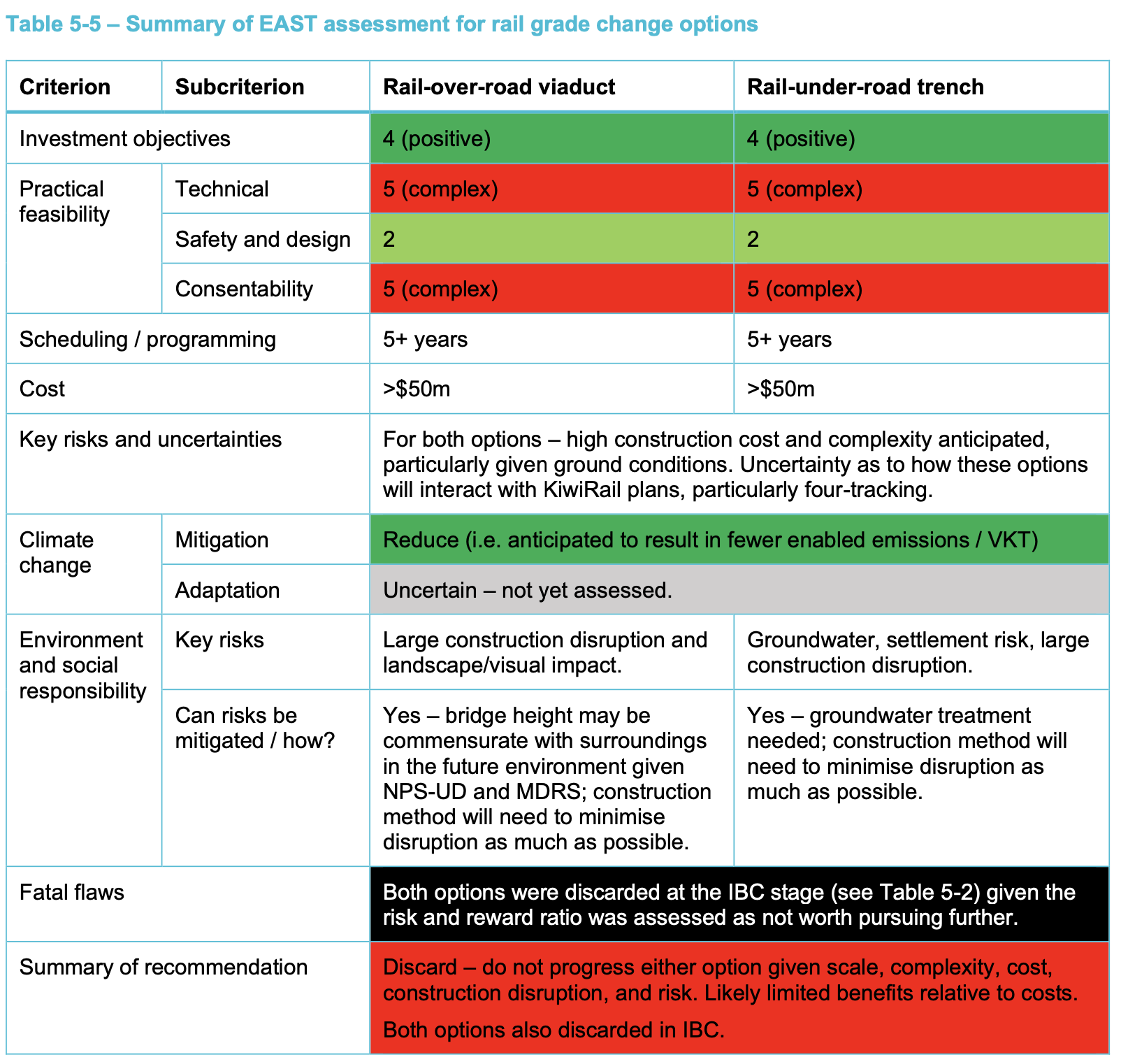
DBC Appendix C
To summarise. It’s great this level crossing removal (LXR) programme is funded, and I hope it can be accelerated in this RLTP period. I hope that it can also accelerate the delivery of the third and fourth mains, and deliver improved place quality – nicer, safer public realm – and much better local access for all modes, enabling bus and bike connections to the rail services.
Improving throughput, reliability, and speed through the core NIMT will really help unlock the currently nearly-there rail programme to deliver us a much more capable urban network.


 Processing...
What about opening the second south exit at Te Mahia station to provide safer access and allowing utilization of the underhighway passage to reach the station? This would be cost-effective but would require consultations.
Also, is there a possibility of reopening the Tironui railway station between Takanini and Papakura?
Better yet, add a station at Glenora Road or Walters Road next to Southgate like what was originally planned.
Hearings for the Notices of Requirement for the Takanini Grade Separations were completed on 7th June so the designations should be in place shortly. However, as AT indicated, the Resource Consenting Process has yet to begin – they and the SGA were unwilling to commit to that until funding was assured – during the hearing they suggested that this might not happen for a long time so asked for the Designations to have a 15 year lapse period – i.e. extending out to 2039! But the Council has now adopted its LTP which includes $600 million for level crossing removals with the four in Takanini having first priority. Given that this work will have to be staged to avoid disrupting the tracks at multiple points all at once, hopefully a decision will be made very soon after the Designations are confirmed to make a start on detailed planning/consenting for whichever crossing point is going to be first – perhaps at Manuia Road as this is the least disruptive site (no existing level crossing) plus it would be a logical precursor to closing the Spartan Road crossing and replacing it with a pedestrian overbridge.
PS – the discussion and illustration for the Walters Road overbridge have been superceded by a new design which was deminbstrated during the NOR hearings. The amended design is asymmetric – retaining the existing Walters Road between Great South Road and the railway as a one-way slip road (so having no impact on access to the businesses and pre-school on the North side). The ramped embankment and overbridge are moved about 15-20 metres to the South, passing over the slip road as it bends South to connect with Tironui Road. I think that an illustration of this new design can be obtained from the Supporting Growth Alliance. While it requires acquisition of commercial properties along the South side of Walters Road, it does resolve a lot of the opposition from neighbouring property owners.
Last thing we need is more disruption on the network let’s give things time to settle down after the current work is completed before starting anymore grandiose schemes. Let passengers get used to using it and let the numbers build. Also give Kiwirail time to try and make the freight network work rather than distracting management with more vast engineering projects. Freight tonnages must increase to justify the vast expenditure that the Labour Govt showed on them. Time for results. No more rail buses.
Patrick, are you suggesting that above or below ground should be re-investigated as part of the detail design process.
If yes, I support above ground as much easier to do. First, build two tracks above ground to one side of the existing two tracks, with raised stations etc. Second, Move all trains up onto this viaduct. Third, build a second viaduct alongside with two further tracks. We now have grade separation at all the roadways plus the 3rd & 4th main plus new space under the raised tracks.
Only tricky bit getting over or under the motorway at the northern end.
Oh, and the cost.
The motorway, and the stream, at the northern end is solved by closing the Spatan Rd and remaining at grade here, as proposed.
For the rest I don’t have an answer, as I don’t know. I am asking for a clearer look for a solution that accelerates desperately need additional track and improved place quality for this investment through here. Ambitious I know, but the DBC itself confesses it was done in haste.
I love clever engineering, the word after all is from the same root word as ingenious. Creative problem solving.
Additionally I note this is a very road focussed programme (not even grade separating the stations) yet is funded 100% from the PT activity class.
It’s very clearly stated that the options were discarded due to the peat soil and its effects on construction. Engineering analyses were carried out to analyse this and found that it just isn’t feasible to proceed with those approaches. I don’t see why you would ignore their comments in favour of anecdotal evidence.
If it’s ghastly and land-hungry or double the cost, which one are you picking? We could leave it as it is or try to get as many benefits with the smallest cost possible.
Designs for the bridges will include space for the 4-track Designation.
Any works here have to deal with groundwater and flood flows, in ground like a soggy trifle.
Soggy trifle is right.
Much of Chinas flat areas are similar.
They have a lot of elevated rail, assume with very large deep piles.
So it could be done but not cheaply, and with many demands for money elsewhere its a good reason for the selected option.
Unulating elevation changes to the railway will have devastating effect on freight haulage, so whether we go up or down (or even remain where we are) level operation is important.
l spend half a year in Asia every year where l notice that elevation is the major method of grade separation and taking out gradients in the track.
Also, China has successfuly conquered soggy spongy ground numerous times, as have Singapore, Taiwan and Japan.
lf we can’t learn from those that have gone before us, we are doomed to make the same errors, again.
l support an elevating or trenching (even covered were community’s ask) a four track pathway (even if not used initially).
l am reminded of discussions regarding the number of entry tracks into Britomart and how designers were deaf to our calls (with extensive
examples, encluding our own Wellington station) for four lines minimum. l read in the Herald some years later that the the head of what would become AT headlining “lf only someone had told us that two lines would not be enough….”
Well two is still not enough.
Thank you
The only way to officially get funds for any project to start is to make it look inexpensive.
Once funds are dedicated for 2 lines and work begins, you can request additional funding for a wider one. This can be done after the initial stages are completed.
than 3rd line.
And finally the 4th
Eventually, you might secure 3-4 times more funding, which should be sufficient.
If they do go for a Melbourne style Skyrail solution I hope they don’t make the mistake made on the Caulfield Dandenong section (thru Carnegie) where they only provided two tracks (and no future proofing from what I can tell). Cranbourne/Pakenham metro services, Gippsland Vline services with severely limited possibly for freight thru the corridor. A lot of logs on the parallel princess highway unfortunately.
Elevated, yes could be a good proper idea if it was given a chance.
Supporting Growth were not interested in the future of the Takaanini Train Station as it was outside the scope of the project. They propose building an expensive pedestrian/cycling overbridge at Manuroa Road which will then be duplicated one hundred metres away at the new Takaanini Station required for four tracking.
Lets try a thought experiment on that then.
The replacement Newmarket Viaduct cost $244m, was finished in 2011, is 690m long and 28.7m wide with double four traffic lanes . It is built on twinned piers, has two curves and the build included the cost of dismantling the old viaduct.
It’s 3.5 Km from Tironui Reserve (south of Walters Road) to Te Mahia station.
that’s five times the length of NMKT viaduuct, so let’s start with
– five times $244m – say $1.2B
– reduce by 40% because it’s half the width = $732M
– halving the number of piers probably cancelled out by deeper piers – no change
– reduce by another 15% because there are no curves = $622M
– double because of inflation = $1.25B
– then add elevated stations ($500M) = $1.75B
Three times what is allocated but it does not require heaps of land acquisition and contributes to place making.
I’d vote for it.
What effect does earthquake requirements have on elevated rail? What happens if in the future the specs change? There’s plenty of now useless buildings in NZ that are lying derelict solely because EQ regs changed and they’re not viable anymore.
That’s exactly what happened to the old Newmarket viaduct and yes it could happen again. It’s just like buying the latest phone, you can wait and wait and wait until the perfect phone arrives but you’ve lost so much usability in wait time.
buy Samsung, Apple is not worth waiting
I’m sorry but disruptive period doesn’t cover the nonsense AT is doing with the trains. After suffering through NINE MONTHS of no trains and a joke of a rail replacement bus (20 minute frequency and it got stuck in traffic constantly with massive delays), the weekend shutdowns seem like a slap in the face. With nine months of work, I expect that all the track, wires, signals, ballast and everything has been replaced – of course this isn’t the case and AT just messed around for that time. At this point I just assume that the trains aren’t working and now try to avoid using them because a signal might fail or it might just be too hot. Driving just doesn’t have the same issues and is so much easier. All of this work should have been done 15 years ago when ridership was tiny and the consequences less. I would be incredibly surprised if CRL opens and there are no more problems on our rail network. I’d expect the issues to increase due to the increase in complexity. This just isn’t a proper transit system and it is ridiculous how AT still receives central government funding for rails when they don’t even provide a good service for people.
I don’t even care if AT blames Kiwirail, if the situation isn’t working then talk to central government and sort it out. It is AT’s logo on the side of the train so I’m blaming them. Kiwirail are clearly useless (just look at the ferries) and AT just need to sort out the issues themselves.
What if the passenger service (essentially creating 2 new lines) were elevated with new stations – and leave the freight at level crossings? Much less frequency then.
Probably silly but could be looked at
Westfield – Wiri will eventually need 8 tracks (4 local with Eastern and Southern overlapping there, 2 regional, 2 freight). But at a bare minimum it should have 5, so local trains aren’t slowed by freight/regional services.
Reopen Tironui station , Purchase the units on Tironui Station Road , This will tie in with the slip road and Tironui reserve plus add the needed carparking for the reopened station and room for the extra tracks .