One of the few public transport projects the current government have said they support is the Airport to Botany project (A2B) and it’s one we haven’t covered in a while so worth looking at where things are at.
A business case for the project was completed in 2021 before being confirmed by the boards of both Waka Kotahi and Auckland Transport and like the Eastern busway it will connect to, includes some big roading components too.

The key features of the A2B recommended option are:
An 18 km rapid transit route connecting the Airport and its employment areas with two major urban centres (Manukau and Botany). The route connects to four existing and proposed rapid transit lines and 24 local bus services, some of which intersect multiple times, resulting in more connections and increasing the variety of public transport opportunities for customers in South and East Auckland.
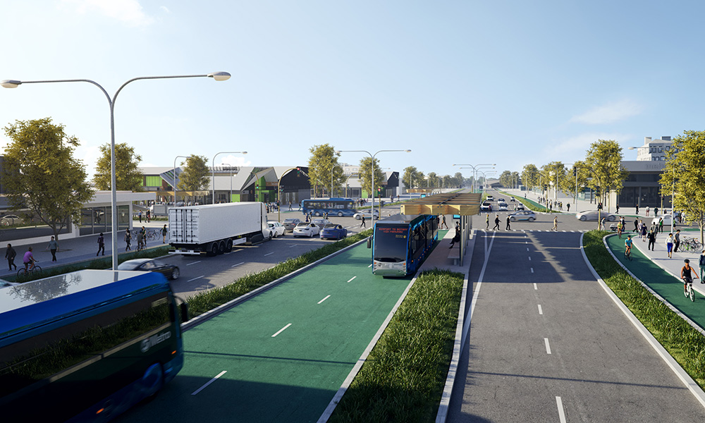
The preferred option for the rapid transit is a BRT system that can be scaled to meet demand as it grows and includes:
- Dedicated running ways, with at-grade intersections
- Twelve stations with off-board ticketing, level boarding and all-door boarding (all provided to reduce vehicle dwell times, and more reliable and accessible services)
- Connections to four existing and proposed rapid transit lines, including the proposed City Centre to Mangere (CC2M) LRT at the Airport.
- A single bi-directional service between the Airport and Botany (designed with flexibility to incorporate future additional services) with headways of as short as three minutes during peak times
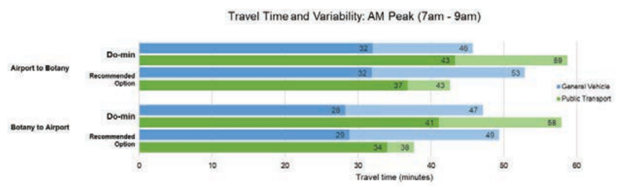
- Fast, reliable journey times of 37-43 minutes (Airport to Botany) and 34-38 minutes (Botany to Airport)
- Potential to promote and support transit-oriented development at key centres
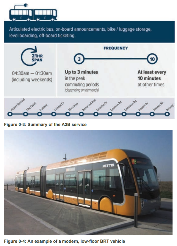
Figure 0-3 and Figure 0-4 illustrate the recommended mode of operation for the rapid transit component. The span of service is proposed to be as long as possible to meet the needs of shift workers and travelers.
The recommended A2B option comprises the following active mode elements:
- A separated walking and cycling route along the entire corridor, running parallel with all upgraded sections of the route.
- Walking, cycling and multi-modal interventions and opportunities, including bike storage facilities and footpath improvements, providing quality access to stations and potential expansion to further improve accessibility in the area.
State highway infrastructure improvements, which include improvements to SH20 (between Mangere Bridge and Manukau), SH20B and the northern section of SH20A. These improvements will provide for more general traffic and freight movements, including those traversing the strategically significant Western Ring Route, reduce the use of local roads and protect access to and around the Airport and Southwest Auckland.
The preferred option for the highway elements of the A2B and 20Connect includes the following treatments:
- Widening SH20B to 4 lanes expressway with at-grade intersections and operating on the existing alignment. In particular, the SH20B section includes:
- The four programme partners are working together in relation to a review of the multi-modal capacity of the Pūkaki Creek Bridge within the Airport RCA area, to cater for predicted growth and development in the southeast
- Rapid transit corridor on the south side of SH20B, enabling the rapid transit route
- New SH20B to SH20 southbound ramp at Puhinui motorway Interchange (includes widening of SH20 south of SH20B southbound to Lambie Drive), removing a significant movement conflict point between general traffic and rapid transit – resulting in improved journey reliability
- New SH20A to SH20 southbound ramp (includes widening of SH20A northbound from Kirkbride Interchange) removing general traffic and freight from local roads in Mangere
- Widening SH20 north of SH20A to eight lanes, improving journey time reliability on the Western Ring Route
- Widening SH20 between SH20A and SH20B to six lanes, to better integrate the new SH20A to SH20 ramp and improve resilience of the network
It already feels like this is more information than we got from most of the Light Rail Project – for which we still haven’t even seen a confirmed route or station locations. I also like that they’ve highlighted articulated buses with level all door boarding to help minimise dwell times. Our trains and Double deckers often have terrible dwell times and it’s an area that we need to do a lot better at.
That’s also quite a significant road component, including widening almost all of SH20 from the Mangere Bridge through to Lambie Dr and building a dedicated busway alongside SH20B – that was just widened for buses a few years ago.
The two new lanes that were added to SH20B will presumably become general traffic lanes and one nitpicky concern I have around it is that Waka Kotahi raided the public transport budget to pay for it, which is one of the reasons Labours increases to the PT budget didn’t seem to achieve much. Given a full busway will undoubtedly also come from the public transport budget, especially with this government, we will end up with motorway widening paid for by public transport.
The business case also recommended a staged delivery. The first stage, which included things like the Puhinui Interchange, SH20B widening and the AirportLink bus has been completed so the remaining proposed stages are below.
- Horizon 2 (H2) (2025) – A2B medium term premium bus service – a premium pre-rapid transit connection supported by relatively low capital-investment bus priority interventions, particularly between Manukau and Botany, to extend the ‘AirportLink’ bus service from Airport to Botany, with stations established at their long term locations prior to their upgrading and completion in Horizon 4.
- Horizon 3 (H3) (2030) – Opening of the A2B rapid transit service – targeted infrastructure upgrades on SH20B and SH20 south of SH20B to Manukau, including a four-lane expressway, a dedicated busway on SH20B, a shared path along SH20B, a new southbound SH20B to SH20 connection, a bridge for A2B over the rail lines at Puhinui, and ultimate A2B busway infrastructure and two stations in Manukau City Centre to support central and local government urban regeneration initiatives. Also includes Botany Station Stage 2 upgrade.
- Horizon 4 (H4) (2035) – Full A2B rapid transit service and infrastructure. Dedicated running way for BRT between SH20/SH20B interchange and Botany. Establishment of new A2B stations between Manukau and Botany and at Lambie Drive. Walking and cycling facilities extended to Botany.
- Horizon 5 (H5) (2040) – SWGP final implementation – completion of the SH20 and SH20A upgrades, which involves highway widening and a new southbound SH20A to SH20 connection. Shared path alongside SH20, between Mangere Bridge and SH20B.
Staged capacity increases rather than trying to build everything at once, another thing Auckland Light Rail could have learnt from and at least most of the motorway widening is part the last stage.
Looking at that staging on the impact to public transport capacity.
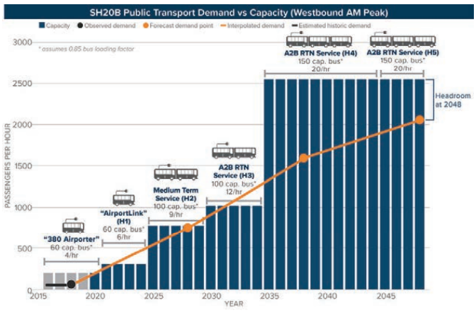
Along with increased capacity comes faster journeys and increased reliability. The chart below shows travel times at both peak and off-peak for vehicles and public transport.
The business case also notes that the design does allow for potential conversion to light rail in the long term.
The estimated cost of the project has been redacted but are already likely out of date with the recent inflationary impacts of transport projects. However, National’s transport policy claims the project is about $2.1 billion and they want half to come from the Council.
Despite the cost, the project has a decent Benefit Cost Ratio (BCR).
The BCR is 2.5 for the A2B rapid transit and SH20B sections and 3.0 for the full programme, including the later state highway components (Horizon 5)
Following on from the business case, though the Supporting Growth Alliance, a notice of requirement (NoR) was lodged just over a year ago. During 2023 the project went through the consent process and late last year a decision to approve it was made. A month ago, Waka Kotahi and Auckland Transport announced they had accepted the recommendations
NZ Transport Agency Waka Kotahi (NZTA) and Auckland Transport have now lodged decisions on the Notices of Requirement with Auckland Council for the Airport to Botany Rapid Transit project.
[…..]
The decisions on the NoRs follows NZTA and Auckland Transport receiving Council’s recommendation from their independent hearings panel. The hearing was held in August 2023 and Council’s recommendation was issued last December.
Auckland Council will now inform submitters and other interested parties of the decisions and the 15-day appeal period. It is anticipated that the designations should be finalised by the end of 2024, subject to resolution of any appeals that are filed.
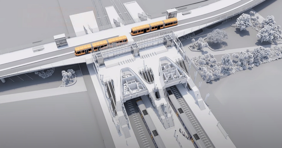
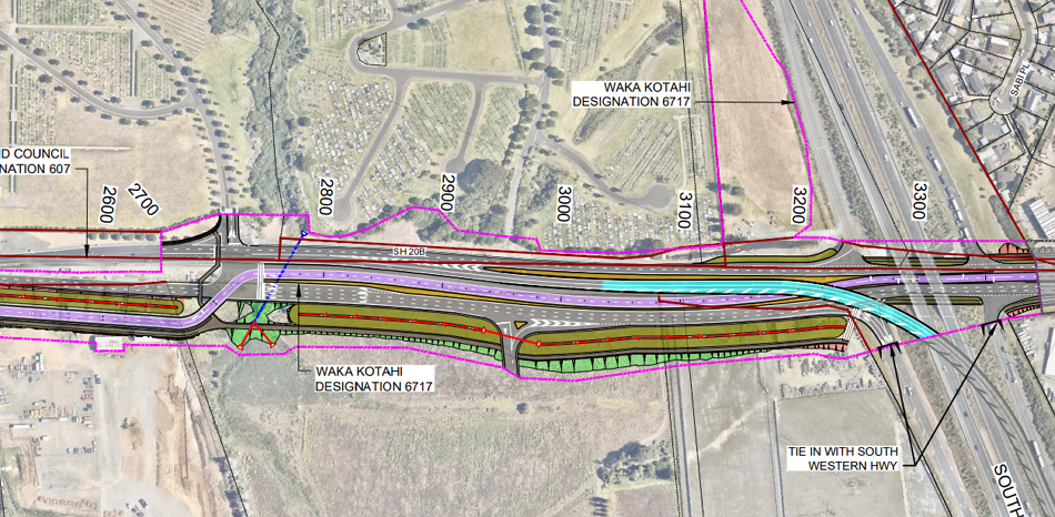
Those NoRs confirm that the plan is for a centre running busway along Te Irirangi Dr where the existing median will be replaced with a busway. It also shows that stops along this section will be split over the intersection – much like is going to be happening with the Eastern Busway.
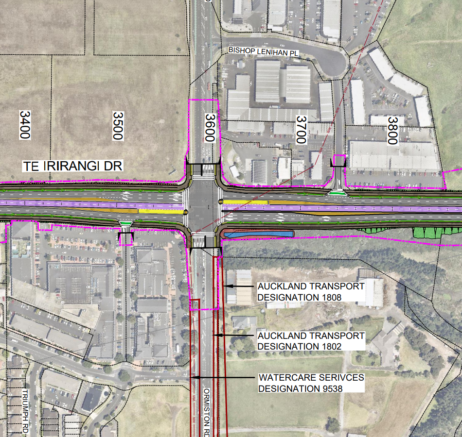
Along SH20 the busway would be the southern side and needs to cross the westbound traffic lanes to do that. You can also see that part of the project includes a ramp between SH20B and SH20 southbound.
The project looks ready to be able to move to the next stage. As part of the recent announcement about the NoR, Waka Kotahi and AT said
Current priorities for NZTA include finalising construction of the Eastern Busway, and alongside this planning will also be undertaken in the next three years for the delivery of the Airport to Botany Busway.
Project planning, funding and construction timeframes will be confirmed with the release of the National Land Transport Programme (NLTP) later this year.

 Processing...
Those BRT buses look to be exactly what Auckland needs. Considering Dominion Road / Queen Street is virtually straight (a couple of bends on Ian McKinnon), why not buy some tomorrow, make the bus lanes 24×7, and get most of the benefits of LR for a few bucks in a few months? Surely a $150 million solution would have a better business case than a $15 billion one, unless LRT has 100x the benefits of BRT.
Where are all the knockers who have in the past labelled BRT (whether autonomous or driven) to be a “toy” technology which should never be allowed to darken Auckland streets? It’s good to see that people can now see the technology as being as unthreatening: it’s just a large double-articulated electric bus. I believe it could easily find a place on other routes like (dare I say) the Northern and NW Express and Dominion Road, also from Ellerslie to Botany. Because, let’s face it, LR is out of the picture for a generation after the last few fiasco years. Thanks, Labour. Not.
Agree, at a minimum its just a bigger bus that is tricked out more like a train, I used to catch something similar in London 20 years ago. Boris Johnson banned them from London, but London has much tighter streets than here, and also he is a moron.
Still not quite the labour (& wear and tear?) efficiency a larger LRT vehicle would bring but it’s getting there.
As a current daily user of them in West London, they are just a longer bus with a higher potential for fare evasion which was the real reason TfL got rid.
Given fare evasion issues Auckland already has, this is the last thing that’s needed.
If everyone uses a plastic card or phone to board, buses Double Deckers take no longer then these do as you’ll find the back doors will be closed off for boarding.
The different is the A2B project did propose large double articulated electric buses…. and not the so called trackless trams which don’t fit NZ design rules.
Can you turn those around in the city? This is a key reason they use the double-deckers on city terminating routes. Of course, they could make the Dominion Rd (25) route continuous with the Northern Busway one (NX1) to solve that problem & also use it to replace the City Link. Run it early and late into the night. Could it even become the southern link to the airport ie replacing the 38?
The CBD should not be the termination of any route. We are spending 6 billion to fix that for rail!
Yes the 25 -> NEX seems like a good fit. If the NEX needs more frequency than the 25 they could do the Sandringham and/or Mt Eden as well.
Yes, the route getting quite long, but could just operate on a headway system or have extra short runner ones as well.
At the Mt Roskill to Onehunga end it could go via the current 670 route rather than waste it’s time on the motorway with not stops. Upgrades later for light rail or special route & stations next to the motorway.
The Hibiscus Coast & NX2 routes could handle the split of the 25 to Blockhouse Bay (25L) & Lynfield (25L). Hmm that would be too much to one or the other so perhaps the NX2 is better to join with the 36 to Manukau.
I hadn’t really considered taking it all the way to Mangere. Maybe Mangere would be better served by another route such as Manukau Road. Could easily do 20+ routes for the price of one tunnelled LRT.
Yeah looking into it more and looking back on this older post:
https://www.greaterauckland.org.nz/2022/04/19/through-routing-buses-2/
Matt L suggested linking the 82 with the 30 (& I think the frequencies align better now they have reduced the 82). You could then make this continue to the airport 38.
Regarding NX services, you could run:
1. NX1 – City (City Link) – 25 (Dominion via Ian McKinnon).
Would be a boost for the city & Dominion Rd legs at peak, or could split it to Sandringham and Mt Eden Rd’s I guess)
2. Hibiscus Coast – NX1 – City – 25B (via Ian McKinnon).
3. NX2 – City (Uni/Wellesley/Symonds St) – 25L (Dominion via View Rd perhaps).
Then *peak direction only*:
4. Hibiscus Coast – NX2 – City (Uni) – 25 (via Ian McKinnon) – 36 (Manukau via Carr Rd, Onehunga Transport Ctr) & Station.
Auckland has previously had bendy buses and in theory these should be more manoeuvrable than them. Also through running, we don’t really have many really tight spaces that buses need to go to.
Double deck buses have advantages in many cases, but these could also be part of the solution. Routes like the NEX could even look at articulated double decker buses – double the capacity, still 1 driver.
Double decker buses are very slow to load/unload, and not good on routes where there are people getting on/off at a large number of stops. The route I’m on has them and they take ages at peak times.
Yes, and just landed this video about using the right bus for the right job:
Double decker buses are better for enjoying a can of beer on compared to bendy buses. There is usually a security camera blind spot on the front seat on the top deck.
This project seems another water or money like the eastern busway. Will only make traffic worse and help almost no one. Most people in botany aren’t going to the airport each day. The new lanes should be for cars and focus getting rid of all the lights on ti irirangi. Make it more like the south eastern Highway linking with motorway and airport exit. This is what is needed. Plus those silly buses are going to be expensive, just use what we have already.
There should be flyovers (or underground tunnels) constructs in every intersections from SH1 to Te Rakau Dr with three lines each directions and two lines each directions for all flyovers, variable time bus lines can be implement and bus stops can be placed under flyovers to stop and interchange (with bus prioritise traffic signal for the intersections under the flyovers). Speed limit can back to 80kph or even 90kph (or with variable speed zone). This will build the BRT while also increase speed and efficiency for Te Irirangi Dr.
That sounds very expensive, and very awful.
2035 for proper BRT is far too slow surely
As both our prime minister and minister of transport / Auckland are ostensibly Botany residents; and the former a former aeroplane enthusiast; this project must surely be their predicted legacy?
For other residents of the eastern sector of our city it is very important also, especially those beyond walking distance of a ferry.
bah humbug
I still don’t get why an extension of the Metro train network isn’t being seriously considered? Obviously it will be more expensive up front, but you get much cheaper maintenance costs in the long run and much greater capacity. Considering the opening of CRL next year wouldn’t we want to maximise the use of this investment as much as possible? Imagine how great it would be to have a route directly from the airport to the city centre with times competitive with driving. While BRT can be used effectively, it just doesn’t make sense why we’re so afraid of expanding our train network
I think our leaders need to go and have a look at the railway lines in all the capital. cities across the ditch they just hate trains in Auckland and New Zealand our railway system is pathetic
Amen to that. NZ is stuck in 1955.
Even the USA is leaving that way of thinking behind.
The current CEO of NZ (read PM) didn’t have a clue about aviation while boss of Air NZ so how could he have a clue about light and heavy rail.
The BRT with multi-door boarding looks good.
Public transport delivery needs a sensible stepped system – increasing frequency, introducing, improving, then separating bus lanes as patronage grows. The advantage of BRT would seem to be that is a good end product and, if light rail becomes desirable later, the BRT buses can presumably use the roads while the changeover to light rail is happening – and then be redeployed to the next route that is growing enough to need them.
Why didn’t they just do this instead of nothing with the proposed light rail?
So that ramp between SH20B and SH20 southbound is another motorway (non public transport) component also paid for out of the PT budget by the looks.
A2B is a straightforward case for RONS funding with perhaps a little Auckland Council top-up for a few elements. With Mill Road Stage 1 reducing some of the intersection delays it should work well except for having to follow a route through Manukau Centre like Worm with stomach cramps.
Have they taken into consideration that many parts of the median strip
on Te Irirangi Drive are not wide enough to take two bus lanes and bus stops?
Yes, they’ve designed and consented it already.
Does it have to be so elaborate and does it have to dog leg to Manukau bus station. How would the articulated buses fit in there anyway. I am not keen on mega projects my type of project is something similar to what has already being done with the airport link buses to Manukau City. Only thing I don’t like about it is Puhinui Station is a bit of a wind tunnel if you are waiting for any length of time. But the layout of the roads and the bus and T3 lanes are quite clever. Surely a similar sort of thing could be done extending it along Puhinui road and over the motorway then along Boundary road the onto Te Irirangi drive. Other buses can and do connect between Botany and Manukau.
Maybe a monorail would make more sense?
As it is they will have to remove hundreds of homes
To make sense, an elevated monorail would need to be running through an area of multi-storey buildings, like this in Japan: https://commons.wikimedia.org/wiki/File:Naha_Okinawa_Japan_Monorail-01.jpg.
I’m not sure any part of Auckland has that kind of density – or plans to.
It doesn’t, Its just needs a corridor & suspended from or straddle a narrow guide way.
Ideally in a perfect world, Monorail would make more sense than BRT. Avoids traffic lights, crossing intersections, general traffic, ability to gain more frequency and faster.
Cost wise though, does it stack up against street level if you have the room at street level?
I tend to think of it as a “next stage” when you run out of street space and assume the cost would need higher density to justify it.
Are buses are the government’s preferred PT option because they don’t pull funds away from roads?
It does look like a good system, those bi-articulated units would be wasted in a part-time bus lane or general traffic.
I see conflict between crossings to access the stops and general traffic flows. Lets hope the pedestrian phases are long enough for non-athletes to reach those buses.
Massive motorway widening? Fine, so long as I get to say ‘slinkybus’.
Off topic but is it only in NZ where anything to do with rail is quite often referred to as a train set? Seems to only be an NZ thing as i don’t recall hearing this term in other countries but I could be wrong?
We’re bumpkins
you are correct.
Ive not heard it once in my time living in North America or Europe.
That’s what I thought.
“Given a full busway will undoubtedly also come from the public transport budget, especially with this government, we will end up with motorway widening paid for BUT public transport.”
I think the but is a typo.
Thanks, fixed
I am seriously worried that our new transport minister will respond to any funding issues with this project by just taking out any multi-modal elements. Especially in tight sections, they could argue that that will save a lot of land acquisition, and hey if there’s not enough cash in the (totally raided) walking and cycling budget to pay for that, surely that shows that bikes and walking ain’t worth it.
The fact that it’s already consented with facilities will help – but given their track record so far, I’d not rule out such actions by them.
National seem obsessed with bus rapid transit, one thing I have found that brt doesn’t attract urban development like rail based transit.
Yes, by introducing new bus services is reason for constructing new road & highway-based transportation infrastructure. Stealth Mode for more roads at the expense of creating multi-modal transportation & rapid transit systems.
Widening SH20B from 4 to 6 Lanes makes no sense unless the issues preventing any more than 2 Lanes across Pukaki Creek is resolved. If AT is going to spend two billion bucks building a fully separated busway, the only suitable solution if the bridge issue can’t be resolved might be to restrict the current bridge solely to buses only.
The complex issues around the 1990s agreement involving MCC, Transit and local iwi was still unresolved at the time the business case was published if my memory serves me correctly, and I don’t think there’s been any public updates on the situation since then.
A LTN design for the area around Puhinui Rd could have prevented the need for widening the road altogether, removing the problem of the pinch point. Instead, AT are acting like bullies on the issue of the bridge. Probably emboldened by the coalition’s regressive views about (dis)honouring Te Tiriti.
So they’re widening the motorways again. Haven’t we been here before? Improvements to SH20, SH20A and SH20B. Climate deniers, you’re out of control.
This significant road widening and property purchase comes at huge cost, while the active modes improvements on A2B consist of an inadequate, non-compliant, “shared path” – delivered late and in piecemeal fashion. All on a corridor that is already wide, when official direction is to reallocate space and stop using the predict and provide planning that is the reason for thinking the extra space is required.
This is not how climate planning is done, AT. It is complete failure.
AT lacks
– Vision.
– Financial management capability.
– Climate planning capability.
– Professionalism. Staff are not keeping abreast of developments in their fields.
– Governance. No one at Board or Governing Body level seem willing to require Council’s official direction about planning approach to be followed.
Please share your wisdom. What is your 10 year plan to overcome congestion in Auckland and at what cost. Please be specific
From experience
If it is suggested $2B
It will be more like $6B or more
An example the CRL
From experience
If it is suggested $2B
It will be more like $6B or more
New comment
An example the CRL
In theory rail would be better but not with the people we have running the ship
Replaced the rails in Auckland then lifted the tracks to replace the ballast?
To me it just looks like the public transit users are getting the portaloo equivalent of transit, that is bus transit, cheap to implement but expensive to operate, no one likes using them, and the next day it might just not exist. But road users get the gold plated throne equivalent, all plumbed in, auto bum washing included. This would be the multi lane freeway. I think toilets and transport have more in common then you think.
Problem is we are starting with nothing for PT – so basically pooing in the woods. At least with a portaloo we get something on/in the ground. And then in time perhaps the portaloo is upgraded to a Japanese bum washer (ie light rail, etc).
If only all this happened 60 years ago with iterations/expansions along the way we might all be riding the clean toilet revolution by now
At least if we have buses people will be able to poo and pee in bus shelters.
never understand this mindset, buses are great, they’re more popular than rail, they are growing faster than rail, the most used transit line in the country is BRT (Northern busway).
As a former frequent user of the northern busway and then moving to somewhere on a rail line I was disappointed. Busway has dramatically better frequencies, longer running hours, and direct access to much more of the CBD. If anything busway users should take pity on Auckland rail users!
Yes the northern busway is popular, I have used it many times, but so is a row of portaloos at a concert event.
Buses to me feel very temporary, for many reasons I have never enjoyed using them, I never quite got used to sitting at the stop on the side of the road watching everyone in there car zooming by while I sit there wasting time, I never liked waving down a bus I always felt guilty for stopping a bus load of people, it was always made worse when you enter swipe your card and look down the isle and see 20 or so people looking towards you, well half are steering at there phone but still sets in stage fright for me, but before i have even thought about putting my card away the driver has slammed his foot of the throttle and swinging hard right, if you don’t grab a bar you will end up on some poor old ladies lap, not that drivers should wait for people to sit before they pull away, but I find buses to be quite a jostling ride anyway, empty buses have no suspension not to mention all the idiot drivers the bus driver needs to avoid. There’s also the who do I sit with situation, obviously I would take a the empty spaces before sitting next to a stranger. But generally I would rather just stay standing, being a middle aged male I don’t take spaces next to other passengers, especially female’s as I don’t want people to feel uncomfortable.
Buses to me feel very invasive. It’s not an experience the typical car driver can get used to. Yes after a few years using the bus most of the things I mentioned above don’t bother me.
But unless you often take flights solo, there is a steep learning curve.
Trains on the other hand feel more like an escalator or lift, you just get on and stand there until your ride is over, and step off.
… and step off into a station. First you have to get out of the station, and then you find yourself in a neighbourhood severed by the rail line, because in Auckland, reducing that severance hasn’t taken priority. This can be fixed; and trains have lots of great characteristics, and even more potential.
But buses are wonderful too. It’s nice to hop off a bus straight onto the footpath. The problem with A2B is that it’s cementing a hostile environment in that corridor when buses could offer so much more, done well. The widening ruins the whole environment, worsening severance.
If you don’t like buses, there’s no need to assume those opinions are held by the majority of people.
You are suffering from Aucklandism/NZism.
If you were in a real city with more reliable, frequent rail transport you’d only look on the bus as the last resort as it is the slowest form of public transport in most cities. It’s quicker to walk in London then take the bus a lot of the time!
People say this, but then you look at stats for a city like Singapore, a typical rail success story. More trips are done via bus than the MRT. And have bus users report better satisfaction than the rail riders there too. I found the buses fantastic when I was there. Never in congestion despite a lot of mixed traffic running (congestion charging), great stop infrastructure.
https://www.straitstimes.com/singapore/more-spore-residents-take-trains-and-buses-to-work-fewer-drive-to-the-office-population
CRL is good, the investments being made in rail in Auckland is good. Rail will support a huge amount of growth more than any politician or most planners think IMO.
But the bus network in Auckland does and always will carry the lion’s share of PT trips. Way more focus should be given to buses and their infrastructure, its simplay more important, a far larger source of ridership and mode shift than rail can be.
Yes but the bus system in Singapore wouldn’t be anywhere near as successful without the MRT.
Most people will be using buses to take short local trips, many will be to the train station, without the MRT people will be needing to buy a car to travel longer distances, the government may be forced to reduce its car import tax and remove its expensive car licensing fees so people can get around the city.
Basically rail or metro systems are the equivalent for public transport as freeways ar for cars, Imagine Auckland without its highway network, we wouldn’t have the congregation problem we have now, but imagine Singapore without its metro network, it will have congregation far worse then Auckland.
Or increase car licensing fees and introduce congestion charging, to encourage single occupancy car users to change their behaviour..
I agree, Jack, and improving the bus network is low-hanging fruit. We have lots of street space that can be used much better.
This is normal with even very good subway/rail networks to have more bus use than train users. They complement each other.
Yes I agree, poor quality transit brings poor results, you can dress it up all like, but in a car centric city like Auckland buses are really only there to support our car centric city, that’s likely why national are happy to build BRT infrastructure.
Buses and cars Go together like poos in a potty.
Rail infrastructure tends to require town density that makes car access difficult.
But I live in Auckland, a bus lane really is all we can get excited about these days.
Trains by contrast are like the Central Interceptor, one potentially high capacity sewer that still doesn’t do anything useful without all the sewers feeding into it from where people actually live, work and poop.
(apparently it’s also useful for transporting giraffes and rhinos and emptying olympic swimming pools)
Mode-share between train and bus is heavily influenced by what services are provided. You cannot ride a train that doesn’t exist, no matter how great your preference for using trains might be.
Buses may carry a larger share of passenger-trips in Auckland than trains, but if you factor-in the lengths of those trips, you find that trains tend to carry people for longer distances. So, measured by passenger-kms rather than straight passenger-numbers, rail’s mode-share rises.
For much of Auckland, rail is not an option. If you restrict your bus-rail comparison to those catchments where both are available, you get a clearer picture of people’s actual preference. Conversely, if rail was provided to areas that are currently not rail-served, the overall mode-share of trains across the region would likely rise dramatically.
Still the obsession with getting to the airport. Most people don’t go there every day – or even every month. Most people want to get efficiently to work or study every day. They want their children to get safely to school and back without crossing major roads. Looping high capacity public transport between residential and commercial/industrial areas will help more people every day. Politicians in cars think the airport is the place everyone wants to go.
Less than 3% of trips to and from the airport start in the CBD, however, you still need to connect Botany, the wider airport precinct, Ascot Park and MTC with the suburbs that work there. The airport recently released figures of how many total trips are made each day, to or from the airport precinct, including, travellers, friends and family and workers.
PS there were 15.9 million passenger trips through Auckland Airport in 2023, not including the wider industrial precinct, workers, friends and family and crew.
The airport precinct is one of the biggest industrial areas in the city…
It has been a year since the press release from NZTA and I feel like we haven’t heard a peep since.
Is it something I can ask AT about?