Tomorrow the AT board have their first meeting of the year. it will also be the first meeting for new chair Richard Leggat.
You can watch the open session on this Teams link with the meeting due to start at 10am.
As usual, I’ve taken a look through the reports to see what stands out. The agenda for the open session is here. Unfortunately no agenda has yet been published for the Closed session.
Board Report
The board report isn’t quite what it used to be but there are still some interesting nuggets in there.
Review of raised pedestrian crossings – following the ongoing and often error-laden attacks on raised crossings by the Herald, and despite their own evidence on the superior safety benefits they offer, AT have been reviewing them across the region and say they’ll reduce the number to be delivered by a third:
the Road Safety Engineering Programme is the only programme that is specifically focused on addressing high-risk corridors or intersections. The programme is co-designed with New Zealand Transport Agency Waka Kotahi (NZTA) and is aligned with the Road to Zero Strategic model and has had a focus on implementing safe system solutions to maximise the reduction of deaths and serious injuries. A review of their use was undertaken across the business, and acceptable safe system alternatives. As part of this review, Transport Safety has completed a stock take of the Road Safety Engineering Programme. Following the review, the number of proposed raised pedestrian crossings has been reduced by approximately a third, and alternatives proposed.
Western Express – AT say:
the service has achieved 100,000 boardings in its first ten weeks of operation. This is well on track to meet its patronage target of 600,000 for the year
That will just be for the new service, so it would be more useful to understand the overall impact of the changes to western buses.
They also note:
Bus priority to support Northwestern motorway service changes: we are seeking commitment from NZTA for the delivery of on-ramp bus priority at peak times. Until agreement is reached, these services remain at high risk of delay at Newton and Westgate
Airport to Botany – AT say that commissioners have confirmed with some modifications their notice of requirement for the Airport to Botany busway. They don’t say what those modifications are.
Transport Funding – AT have been more vocal about funding issues for a while now, and they’re noting it again in a couple of ways.
- They indicate that the quality of roads will get worse.
Road asset maintenance and renewals: our road network has and is deteriorating as a result of underfunding, which is increasing maintenance costs and the extent and cost of pre-seal repairs. Once funding under the GPS and Auckland Councils LTP are confirmed we will update the board on what if any impact there is on the scale and rate of deterioration of our assets.
If I were them, I wouldn’t be holding out hope that the upcoming GPS (Government Policy Statement) will make things any better. We’re more likely to see the maintenance budgets raided to help pay for National’s promised new roads.
- The removal of the Regional Fuel Tax means they need to reconsider what continues to get funded. Which kinds of projects and programmes will remain untouchable, and which will be thrown under the bus?
This means delivery of some of our programmes and projects to improve our roads and public transport will need to be scaled back or deferred.The board will reconsider in the confidential agenda which capital programmes and projects we should prioritise.
CRL/Rail – AT are warning that as part of testing and commissioning for the CRL, further closures of the rail network will be required. What kind of closures and disruption from testing can we expect?
They also say they’re still waiting on Kiwirail to approve their plans for the day-one operations of the CRL.
 Finally, they say they will be going ahead with the removal of level crossings at Corbans Estate and Tironui Station Road East. I guess that means other pedestrian crossings on their list, such as O’Neill Rd and Lloyd Ave, are still under review.
Sustainability Strategy
AT are asking the board to approve their Sustainability Strategy 2024-2031. The strategy is really just a set of nice words and targets that covers not just climate change but also other environmental as well as Social and Economic outcomes.
My main concern with it, aside from the fact it doesn’t seem to grapple with the existing Climate Plan and Transport Emissions Reduction Pathway, is that as with so many plans and strategies from AT, it looks okay on paper but will largely just sit on shelf somewhere until it’s forgotten.

Speed Limits
Late last year, just two weeks after being sworn in, Minister of Transport Simeon Brown wrote to Auckland Transport about changes he was making to the rules for how speed limits are set. The rules were changed by the previous government in 2022.
The Rule has been amended to revoke the deadlines set by the NZTA, including the 29 March 2024 deadline for submitting the final draft speed management plans for certification. The deadlines and targets for reviewing speed limits, including around schools, have also been revoked. The Rule no longer requires RTCs and RCAs to develop speed management plans, and instead allows them to choose to do so.
As part of the Government’s 100-day commitments, I intend to replace the current Rule.
This new Rule will ensure that when speed limits are set, economic impacts – including travel times – and the views of road users and local communities are taken into account, alongside safety.
The new Rule will also implement requirements for variable speed limits on roads approaching schools during pick up and drop off times, rather than permanent reductions, to keep young New Zealanders safe when they are arriving at, or leaving, school.
I consider it is undesirable for RTCs and RCAs to apply public money and resources in developing speed management plans only to have to revisit the plans when the new Rule takes effect. Given this, if you have not already finalised your speed management plan, I encourage you to consider the new Rule before making final decisions
AT had already made changes to speed limits on 39% of roads across the region under previous rules, and seen significant improvement in lives saved and injuries avoided:
Between June 2020 and February 2023 three phases of the Safe Speed Programme introduced safe and appropriate speed limits to approximately 39% of the network. In the Auckland areas where speed limits were changed on 30 June 2020, road deaths have decreased by 30%, compared to a 9% increase on roads where speed limits were not changed. (Calculated over the 24-month period July 2020 to June 2022).
The speed management plan that sits under the rules the Minister is changing is known as Katoa, Ka Ora, and was nearing completion after having been through significant rounds of public consultation. It looks to change speeds on another 24% of the network. meaning speeds on around 63% of Auckland’s network have been reviewed to improve safety.
The priority of Katoa, Ka Ora is to install safe and appropriate speed limits outside all Auckland schools by the end of 2027. Schools that have not been included in this round of proposed changes, or previous phases of the Safe Speeds Programme, will be included in the next phase of the programme. The draft plan includes speed limit changes covering 359 schools, 13 town centres and 982km of rural roads.
The changes proposed in Katoa, Ka Ora will:
- Be easy-to-understand
- Add less than 15 seconds to an average urban 20-minute car trip
- Have simple signs and colourful road markings
- Make school neighbourhoods safer for families so kids can walk to school
- Make rural, unsealed and no exit roads safer for country people
We will keep the current permanent speeds on our largest and busiest urban roads
To give a scale of how much consultation had been undertaken, AT say:
Katoa, Ka Ora is AT’s first speed management plan under the Land Transport Rule: Setting of Speed Limits 2022 (Rule). It follows three phases being implemented under previous legislation. Safe speed limit setting is evidence-based and with regular assessments demonstrating benefits.
The draft plan is the culmination of a high engagement consultation approach where communities and local boards have worked for more than two years to develop an agreed approach to managing speed, particularly near schools. The project team surveyed 200 schools, held 64 workshops, including 21 local boards, mana whenua, 170 partners, stakeholders and community members.
Public consultation on the draft Katoa, Ka Ora: Auckland SMP was completed over the months of July and August 2023, with approximately 8,000 feedback submissions received. (Attachment 4)
The majority (16) of local boards supported the proposed changes after they received summaries of public consultation feedback for their area.
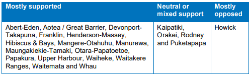
It’s notable that the only local board mostly opposed to the changes is the one where the minister is based. I wonder if that’s been tainting his perception of the issue?
Despite safer speeds now only being discretionary, AT plan to push ahead with at least some parts of the plan, saying:
the draft Katoa, Ka Ora: Auckland speed management plan has an updated targeted focus on safe and appropriate speed limits near schools, marae, and Karioitahi Beach. These all have strong community support
As part of the reasoning for continuing, they note that because of other statutory requirements on them, they “should act promptly once it has reviewed a speed limit and determined it to be unsafe“. They are also concerned that waiting for the change in requirements to come through would also require them to repeat the public consultation – which may add at least a two to three year delay.
It’s good that AT are pushing ahead with this, but it’s not entirely clear just how much of that original draft plan remains. Is it still 24% of the network (or close to it) or just the bits around near schools, marae, and Karioitahi Beach?
If you’ve looked through the documents, was there anything else that stood out?

 Processing...
Why don’t the documents show what remains in Katoa Ka Ora properly?
The rumours are dire; that AT is currying favour with the new government by gutting the programme unnecessarily. Too weak to stand up for us.
Check the Consultation plan on the AT website for Katoa, Ka Ora and you can make your own judgement. It looks like Howick may remain as the outstanding ‘kill zone’ for the region.
So the RFT item says “. The board will reconsider in the confidential agenda which capital programmes and projects we should prioritise.”
What would quality decision-making look like, behind those closed doors?
Most importantly, it would reverse the poor approach used in last year’s annual budget reprioritisation exercise following the Anniversary Day storms. At that time, AT slashed small-budget safety and modeshift projects in favour of large road-widening projects like Eastern Busway, which could have been modified to become a better project at a vastly reduced budget.
We will know that AT has succeeded in overcoming their blind spots if the Airport to Botany Notices of Requirement are rejected. The amount of money being spent on widening Te Irirangi Drive could and should be used to further our actual goals for the city. There is NO reason for widening Te Irirangi Drive.
The Councillors need to take this up, and pronto, because the TERP has already directed AT to stop using inappropriate traffic modelling as the basis for these sorts of decisions. AT’s planning is in error; widening Te Irirangi Drive is not necessary. We shouldn’t be wasting money on property purchase.
I won’t hold my breath. AT’s approach is impoverishing the city, but there’s no sign of an improvement in their decision-making.
Wait…..does A2B involve widening the road? Isn’t the busway/light rail meant to use the existing massive median strip?
Is this like the Eastern Busway where they use it as an excuse to spend loads of money on extra road space as well?
That’s what the Notices of Requirements are for: widening Te Irirangi Drive. The NZH mentioned a figure of 400 properties at one stage, but I don’t know what the current design calls for.
They’ll use the median strip, yes, and yes, they can fit everything required within the space available – that is, footpaths, safe cycling, busway, trees. But to fit it all in, they need to also reduce the number of general traffic lanes to one in each direction. The appropriate time to do this is when the busway and safe cycling and safer walking amenity do indeed allow for massive modeshift.
Unfortunately, the traffic planners are using the MSM model to analyse the project, and it is incapable of modelling significant modeshift or traffic evaporation. They know this, but the model supports business cases for road widening, so they keep doing it – even in the face of Council direction to change.
Their excuse is that freight would be impacted by reducing the number of general traffic lanes. This is incorrect. The enormous network improvements that would come from significant modeshift on Te Irirangi Drive itself would improve freight journeys. Not on the route itself, but at either end of the trip, where the modeshift will have reduced congestion. However, this improvement would ONLY happen if AT reduce the number of general traffic lanes on Te Irirangi Drive at the same time they are introducing the significantly better cycling and bussing options.
Yes this is crazy.
Just had to do a quick Streetmix on this, there is so much width I could widen everything, add in a separate scooter lane (as well as bike) and there is still left over with 2 or 4 general traffic lanes. Wonder why they need to buy properties, maybe at some intersections of bit’s at end of the route?
https://streetmix.net/grantbigcity/80/te-irirangi-dr
Yeah, that’s exactly it, Grant. That’s a really nice Streetmix, and is the kind of transformation we need.
What they’re doing is squeezing in two lanes each way, convinced that it works “most of the length”, and it doesn’t require overhauling the paradigm. It doesn’t reduce severance or make the corridor livable, of course, and it means that, still being stuck at the intersections and pinch points, and in the old paradigm, they still insist on multiple stacking lanes at intersections.
Only by challenging the method and assumptions do we achieve the lovely streetscape that you’ve mocked up.
I am pleased to learn that AT has reviewed the steepness of approach on speed tables as applied on bus routes. The 3 new speed tables being installed on Meola Road are being reduced in height from 150mm to 80mm. I questioned the design of the speed tables being installed in Sandringham Road about 5 years ago as they were far higher/steeper than the design standard used by Transpirt for London. I asked bus operators if they had been consulted – no they were not. So the overly steep platforms went in and bus drivers have to slow to a crawl in the interests of passenger comfort as they negotiate the 10% “angle of attack” – at least they reduced the slope on the down side. There is also an issue on the side roads where speed tables are built at the same height as the footpath. This may give cyclists a false sense of security, leading them to bowl straight across the road in the mistaken impression that all cars will give way to them. This is not so much a problem for those who cycle slowly but could be a risk for those at higher speeds who may appear suddenly with little or no warning for motorists. If the crossing was raised by 80mm rather than 150mm this slight dip below footpath height would clearly signal to cyclists that they should be wary of potential conflict with cars entering or leaving the side street.
Wouldn’t it also clearly signal to motorists in high clearance utes that they don’t really need to slow down at all?
Unfortunately, off-road suspension design for light trucks (utes) makes it impossible to slow them down using vertical devices (unless they are following a car, bus or truck designed for urban road use.
Graeme makes good points that AT has taken note of already. The Practice Note 02 for Raised Safety Platforms is being updated, based on experience and research.
So basically no responsibility on the motorist but cyclists who might want to try feel a bit secure have to compromise on basic safety infrastructure? Don’t the Dutch have these sorts of continuous footpaths?
Slow to a crawl? How fast is a crawl, Graeme?
The problem is NOT with the raised tables but with the traffic speeds.
The solution lies in slashing VKT in half, at the same time as cutting speeds, putting roads on diets and installing critical safety devices like raised tables. Each time people look at one small incremental change required, without supporting the comprehensive set of changes to the whole system, they’ll find excuses for why they don’t like that one small incremental change. It’s not helpful.
As an alternative option they could had it reduce to single lane with chicanes that are planted, looks lot nicer too. Incidentally which costs more as you dont’ have to build a bump designed to handle a lot of impact of heavy vehicle over time?
Airport to Botany has being costed by Waka Kotahi as 3.1 to 4.7 billion dollars. Of course the National Party had costed it at $1071 million but that’s another story. I had envisaged this project as a slightly more sophisticated extension of what we have already got between the airport and the Manukau bus station but apparently I was wrong. Maybe we should rescope the project. A similar level of bus priority to the existing section would in my view be adequate and achievable for the whole project and it could be done at a fraction of the cost. The only part which might require an upgrade or at least increased services would be between Puhinui and the Airport as some services particularly in the middle of the day are getting a little crowded.
Quick short term improvement would be T2 or 3 lanes along Te Irirangi Dr. Watch that free up some road space.
Then scale up to T3/bus when the buses start using using that road.
They could cut costs by avoiding Manukau. Its such a dog leg and a half to get in and out of there. There are easier and quicker routes. Local buses can ply that route and carry on to the airport. Puhinui should be the focus in terms of rail transfer.
I hadn’t thought of that but maybe its the answer. Having a direct Botany Airport service and a Airport Manukau service would provide extra services between Puhinui and the Airport. And as Tom says T2 and T3 lanes on Te Irirangi drive. Cars and trucks on Cavendish Drive and buses on Puhinui road then merge them when the get to Te Irirangi drive which has room for extra lanes. Will miss the green median though.
Exactly. Going South on Te Irirangi drive have a stop at Clover Park. Then head west on Boundary/Puhinui Rd. Manukau can have its own direct service.
Just shows you how Manukau City setup during the car motorway era would of been better built around the Puhinui Station area or maybe in the curve of the rail line more south before Homai (avoiding the Puhinui Creek).
Sadly I think it should go via Manukau with the major bus interchange setup there, this has been consulted on already.
Keeping Manukau as a stop can also make sense as a potentially major employment / commercial area too. Panuku does, or did, own plenty of land in that area, so there’s big potential for land use change and higher density uses in that area.
Manukau has had 50yrs to be a major employment and commercial center, and could still be. I’m not sure being on A2B would stop that. Nothing is stopping it, quite the opposite.
Its on the southern Line, would still have express services to the airport. Its got a big mall, MIT and AUT as well as a host of other attractions nearby. It has lots of potential for more development with Panuku. And other local buses could provide the link between town center and A2B.
Still, I think AT won’t change things because of the bus depot, as Grant says. Shame. Just another example of AT wanting a solution to be everything to everyone and ending up with a suboptimal result overall.
At a staggering but understandable $3.1b to $4.7, does surface running light rail start to come into consideration?
Trackless trams…
“The new Rule will also implement requirements for variable speed limits on roads approaching schools during pick up and drop off times, rather than permanent reductions, to keep young New Zealanders safe when they are arriving at, or leaving, school.”
Simeon Brown actually said this??
How about he listen to what the schools want. It’s not just drop off and pick up times where there are children about.
Totally. Kids are playing before and after school, both in formal care and informal play, on weekdays and weekends.
I think the even simpler problem with variable speed limits is that people tend to regard the speeds they’re used to as safe, and if it’s sometimes different and sometimes the same as always in a given area, absent vigorous enforcement they will most likely just keep driving as they have always done.
The problem is they have used schools as the justifucation to apply permanentl blanket speed reductions across whole suburbs ratger than being targetted as per the guidance.
Hence the backlash and general lack of compliance from all users (eg Pt Chev).
“Blanket speed reduction” is a National party buzzword. Lots of communities are very much supportive of safer speeds in their neighbourhoods and around schools. The backlash is generally from drivers who don’t want to take 15 seconds extra to get somewhere.
No one who actually cares about people would be opposed to safe speeds across whole suburbs, Stu. To use your example of Pt Chev, children walk, scooter and bike to school – and to friends’ places, parks, shops and many other places – from every part of Pt Chev. Focusing on just a few streets around a school is deficient thinking.
Also, you may see everyone speeding in Pt Chev. I see mixed results. Most people are driving more slowly. Plenty of law abiding people are travelling at the legal speed. And there are still some wankers. For an adult on a bike, this mix of speeds is safer than it was before.
I checked the “planned” rail closures coming up and apart from in late evening some rail replacement buses there is 20 minute all day frequency on the Western line from Monday 11 to Sunday 24 March 2024. So good to see it’s pretty good for March madness though that will be hard for out west. Extra rail buses every 10 mins to cover but there are the New North Rd etc buses.
March Madness has started today with the first day of university for a lot of students.
So confirmed, the O’ Line is a shuttle to Newmarket only?
Critics of online gaming often highlight concerns regarding its potential negative impacts, such as addiction and social isolation.