A paper to the Auckland Transport board tomorrow is looking for approval and funding to finally make some progress on another of the key city centre public transport projects – the Wellesley St Bus Improvements (WSBI). This along with the Te Hā Noa – the Victoria St Linear Park are two of the flagship projects as part of the council’s Midtown Regeneration plans.
Recommendations
That the Auckland Transport Board (board):
- Approves the Wellsley Street Bus Improvements Detailed Business Case, including the recommended option and delivery staging to deliver safety upgrades, emission reductions, and mode shift to progress implementation of the Transport Emissions Reduction Plan, bus priority measures and connected cycling facilities along Wellesley Street in the central city.
- Approves a budget of $26.7 million from the Regional Land Transport Plan (2021-2031) Midtown Bus Improvements budget of $132 million to deliver the capital works for Stage One.
- Notes that while outside the prioritised annual capital budget, this is one of the 11 projects approved by the board, in August 2023, to continue subject to ensuring overall capital expenditure remains within the annual budget.
- Delegates to the Chief Executive to finalise and approve a procurement plan and to execute physical works contracts over $20 million for Stage One within the total budget envelope of $26.7 million.
Improving Wellesley St has been on the City Centre Masterplan for some time now the two key focuses for that are to make buses better and improve pedestrian connections, especially around the new Te Waihorotiu station being built as part of the City Rail Link and which will see thousands of people an hour pour out of its Wellesley St entrance. Buses on Wellesley St need both speeding them up and better bus stop infrastructure. This need will only increase as AT say that by the late-2020s, the number of buses using Wellesley St will increase by one-third to almost 200.

The Wellesley Bus Sausage
As noted in the recommendations above, the first phase between Queen St and Albert St is $26.7m but the total plan is for the bus improvements to cover from Symonds St to Victoria Park and the total cost for that is estimated at $174 million.
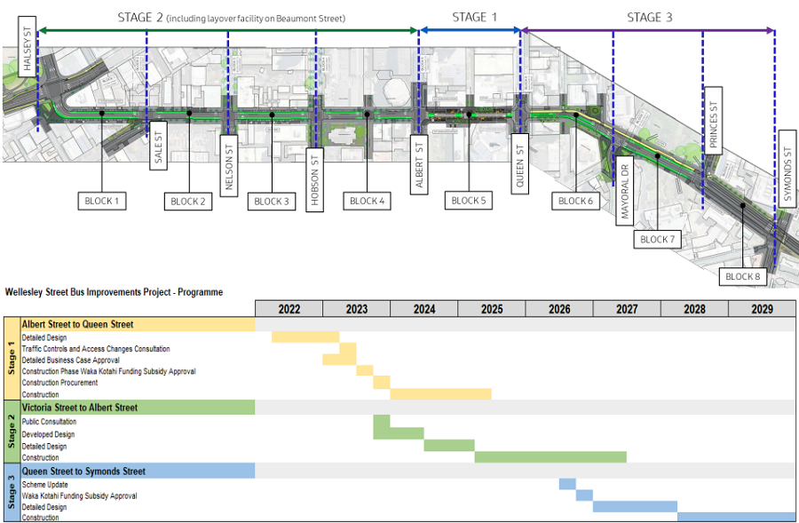
The three stages and expected timing of them

That Benefit Cost Ratio far is better than what you’ll find for most motorway projects
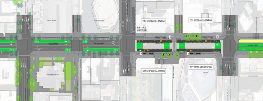
The Stage 1 design was consulted on in 2021 and confirmed last year and will see the section between Albert St and Queen St become bus only. That will not only speed up buses but allow for the footpaths to be widened and bus stop infrastructure to be improved.
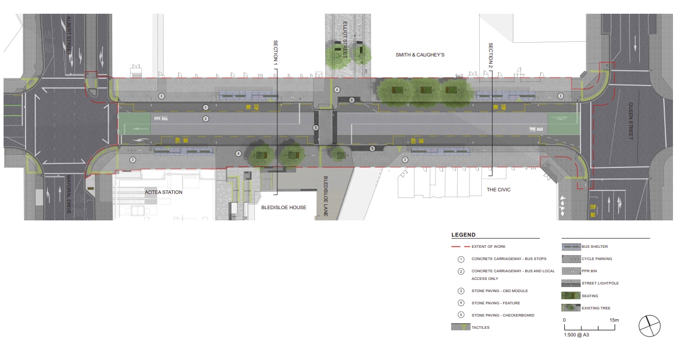
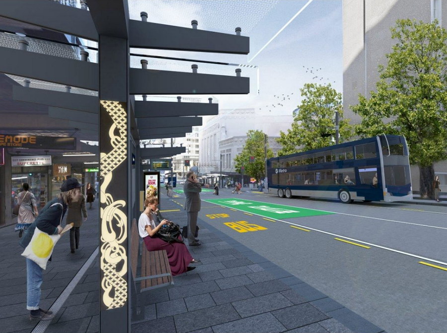
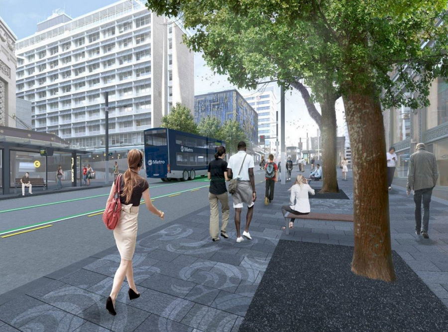
The design above isn’t new but these artist impressions are, and they show a much nicer street environment to what exists today.
By making this section of Wellesley St bus only it should also help improve the Elliott St Shared Space as there shouldn’t be as many cars using it.
The recommended designs for the future stages will provide near-continuous bus priority along the corridor.
The Western end of the corridor is at Victoria St and includes the removal of the slip lane onto Victoria St West as well as the connections to Drake and Vernon St which will allow for a new plaza.
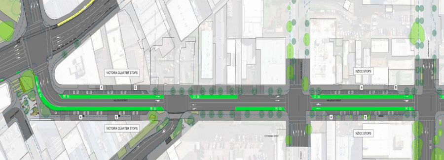
The design above continues through to Albert St where it will join Stage 1.
Stage 3 runs from Queen St to Symonds St and will see a cycleway added on the Northern side – hopefully eventually extending under Symonds St to Grafton Gully and the Domain. It also includes the removal of the slip lane onto Mayoral Dr – though I am a bit concerned this will result in cars backing up and blocking buses trying to get through the intersection.

Here are some of what AT say are the key aspects of the plan.
- The project will provide infrastructure to enable increased bus boarding by 25% and reduces journey times by 14-23% and kerb side priority lanes for up to 200 buses. It will also support the increase in foot traffic and increase the overall customer experience by delivering safe connected, and efficient walking and cycling facilities that enhance the public realm.
- Delivery is in three stages to align with external projects, as shown in Attachment 1. Stage One is aligned with the CRL delivering Te Wai Horotiu station. Stage Two (between Victoria and Albert Streets) is aligned with the Council’s Victoria Linear Park project and Stage Three (between Queen and Symonds Streets) is aligned with Waka Kotahi New Zealand Transport Agency (Waka Kotahi) and Council’s City Centre Masterplan (CCMP) upgrades to Grafton Gully.
- Stage One will provide infrastructure to support increased bus frequency and to support increased foot traffic through engaging streets and spaces that are safe, connected and efficient for people moving along and across the Wellesley Street corridor, see Attachment 2.
- Detailed design for Stage One has progressed in coordination with the design and construction of the CRL programme. Approval is now sought to deliver the infrastructure and pedestrian provisions surrounding the CRL Te Wai Horotiu Station, so they are appropriate, safe and provide a seamless customer experience the station opens.
- Stage One implementation work is planned to commence in April 2024 over an 18-month construction period in alignment with CRL to achieve efficiencies through a “dig-once” approach. Completion is planned for September 2025. The P50 cost estimate of Stage One is $26.7 million, with a Benefit Cost Ratio (BCR) of 3.4. A Waka Kotahi funding application will progress following the board’s approval.
- The project is Regional Fuel Tax (RFT) funded, and the Regional Land Transport Plan (RLTP 2021-2031) has allocation of $132 million for Midtown Bus Improvements with $59m allocated up to FY24 for Stages One and Two with an additional $73m from FY27 for Stage Three.
If there’s one concern I have it is that outside of the improvements in Stage 1, most of the benefits could probably be achieved quite with a bit of green paint. Instead, it seems we’ll be waiting 5-10 years for the council to find funding and there’s a good chance that will be made much harder if the incoming government implements their stated transport polices, including cancelling the council’s source of funding for it, the regional fuel tax.
Overall, the changes are exciting and hopefully fully the AT board approves them tomorrow.

 Processing...
I’m assuming the confirmed bus only section between Queen and Albert is what has prompted the recent flurry of criticism in the media about the general Queen St improvements and the bus/goods vehicles only zone on Queen St from Wellesley to Wakefield Sts by Heart of The City and property owners? A rearguard action to try and stop any further reduction of car accessibility in the central city?
Green paint for the whole length immediately. Streetscape improvements piecemeal as budget allows. Seems obvious, what am I missing?
You’re missing nothing. Indeed, AT know they need to do this.
AT wrote in a paper presented to the Board in August https://at.govt.nz/media/1992609/210-planning-for-investment-in-auckland-s-transport-system-2024-2034.pdf
“13. Specifically for Transport, AC is looking for any investment it makes to prioritise making the most of the existing assets and spend in transport, including optimising investment in CRL. The funding needs to address the needs of a growing population and invest in a balanced transport network. AC is looking for a shift from large sale projects, to getting the most from the current network and is looking for this to be achieved by funding tactical improvements and implementing policy that better manages space for efficiency and mode shift.”
Yet this hasn’t trickled down into actual projects yet. Surely it’s time?
tactical improvements vs $27 million to do 160m of road.
$168 million per kilometre, hmmm
$168 million per kilometre is just total bananas and should be shut down immediately. It doesn’t involve anything like new bridges, new roads, new buildings, but just large amounts of green paint, white paint, and some concrete tim-tams. Seriously, how in the world could it come to that much?
What 27m for what 160m of road? I couldn’t find that in either this blog or the link above?
Thanks, found it.
The most charitable approach is that there will be a lot of utility and urban design changes & improvements going on at the same time, but agree, it seems pretty high. But hey, it’s a PT project, so expect the Herald to run a good faith* campaign to reduce costs.
*Not actually good faith.
And it’s not nearly at East West Link costs/km though. Couple of billion for 4kms of road, here we come, thanks to National!
It’s not just bus paint, it’s a street upgrade.
So it’s moving the kerbs, redoing drainage, paving the widened footpaths in bluestone, planting, shelters, furniture and lighting, probably more.
Yes so contrary to their policy for “a shift from large sale projects to getting the most from the current network and is looking for this to be achieved by funding tactical improvements”
If you were following that, you’d do all the reallocation with a bit of paint for the full length, then come back and build the new kerbs, redo the drainage etc etc with whatever funds are left.
Damien is onto it, I don’t know if you have ever done any work in the central city but there is an absolute spaghetti of utilities running under every street, these need to be shifted out of the way of new foundations and kerbs. and they aren’t cheap to do.
A concrete road will cost more to lay initially, but they have 50 year lifespans compared to asphalt with a 10 to 18 year lifespan (assume lower end for a busy road like Wellesley with hundreds of buses every hour) and replacement of that would easily exceed the budget over 50 years. I think AT might finally be doing it right here. “Do it once and do it right” is how it should be, not piecemeal slapping on some paint and a few hit-sticks, we all saw Queen St during covid, what a mess!
I wonder how the ‘local access’ for vehicles other than buses will be enforced? Also, will bicycles and motorcycles be allowed in the bus lanes? I know they are typically not allowed in ‘bus only’ lanes… and signage around Auckland is often confusing or contradictory.
I can’t think of many bus only lanes in Auckland that bicycles aren’t allowed in, where are these?
Generally only applies to things like bus shoulder lanes on motorways. It requires a “bus only” sign and that’s not how most bus lanes are signed (compare “bus lane” VS “bus only” signs).
In Wellington, Manners Street is ‘Bus Only’. Although few people on bikes pays that any respect, including myself.
From feedback report:
“Reducing the number of cars in this section of Wellesley Street will help make it safer for people on bikes, however, there will be a large number of bus movements in this area and the WSBI project does not include separated cycling facilities. It is intended that people on bikes crossing through the city centre will use Victoria Street, where, as part of Te Hā Noa Victoria Street linear park, a separated cycleway is to be introduced.”
Would be nice to allow confident cyclists through Wellesley St too. Could be pretty dangerous with a pile of buses pulling in and out but downhill might be fine.
There are plenty of transit malls which accommodate bikes safely to use as a model.
AT, think about access to the properties along and near Wellesley St for people on small wheels.
I was looking at this yesterday and noticed something else: this project is the first to include a climate and sustainability assessment that responds to the recent Board request for more reporting on Transport Emissions Reductions Pathway (TERP) progress, etc.
I’m impressed; the template of the reporting matches the TERP Section Two layout, with the targets listed along with how the project contributes. I think this is great for clarity and good decision-making. In another comment, I’ll discuss some questions this assessment raised for me.
Project-based assessments can only go so far to giving the Board the information they need for good oversight however. There will also need to be some Climate and Sustainability assessments of progress towards the TERP’s Section Three. That is, on things like Allocating Existing Funding More Efficiently, and Overcoming Organisational Conservatism, specifically on things like traffic modelling.
Hopefully the Board and AT have together worked out the template for that reporting, too. Good stuff.
$170m and there are still loads of section with turning lanes instead of bus lanes, great
It’s insane what things cost here.
Most of the budget for this should simply be on enforcement once the lanes are reallocated. Get CCTV out to monitor all of these important intersections. Proper yellow hatched paint on all bits where cars are not allowed and strict liability enforcement like they do in the UK. Decent fines $300? People will get the idea that you cannot just block intersections holding up buses.
Also can we stop building shared spaces at all and put in proper cast iron bollards?
Yep seems crazy that some green paint could fulfil the main aims immediately, then stage the pedestrian and street improvements as and when starting with around the station. But nah, crazy expensive, multiyear planning and probably only end up with stage 1 anyway approach of Council and AT.
Looks good however, hopefully happens in its entirety.
Not sure its a good idea trying to do the improvements and kerbs after the station is open, if those predictions on pedestrian numbers are even only half correct there will be a huge number of people milling about. last thing you want is to be trying to work around them. Stage 1 is all that they are approving (approved as of yesterday)
Hope seems to be all we have, so I guess we should be hopeful?!?
In the Climate and Sustainability assessment https://at.govt.nz/media/vw2nt1nu/163-attachment-3-climate-change-and-sustainability-considerations.pdf there is good progress noted on the TERP’s goals for active and public transport (Rows 1 and 2). However:
Row 4: “Reduce travel where possible and appropriate. ~8b Vehicle KM travelled” informs the Board that: “N/A – this project is not anticipated to have an impact on reducing travel.”
Now, it is great that AT recognise that just improving public and active transport won’t reduce VKT by itself; the details of how it is done matter. If they’d realised that about the Eastern Busway, for example, the business case would’ve been different. Thus, the assessment of whether it could be radically modified to a road reallocation project, for this year’s constrained budget, would have been very different to the nonsense in this report: https://at.govt.nz/media/1992051/196-attachment-6-capital-programme-update.pdf
However, the Wellesley St project should indeed lead to VKT reduction. In this reporting, the Board members can see clearly that AT don’t think it will. This is, in fact, an excellent opportunity for asking them about their analytical methods for determining the effect on VKT. In other words, it’s an excellent opportunity – just as the Eastern Busway was – for getting to the bottom of the problem that the erroneous traffic modelling causes. For Wellesley St, AT’s modelling probably mistakenly shows VKT affected by drivers “having to drive further” instead of proper, up-to-date understandings of how changes to traffic circulation, coupled with public and active transport improvements, reduce VKT.
This is further shown in Row 5 “Safe low-traffic neighbourhoods for people”… Nothing too bad in that assessment except for one gaping hole: By now, AT should have a detailed Low Traffic Neighbourhood plan available that fulfills the City Centre Masterplan objectives. It should have a modern VKT assessment, and Wellesley St should simply be part of that. It should form part of the Wellesley St documentation.
But it’s not there. This is an EXCELLENT outcome of the Climate and Sustainability reporting; it’s shown clearly what is missing. The Board need to follow up on this, and request that LTN plan now.
I’d like to see detail on VKT. As the Auckland population has been growing at 2.8% p.a. this year, my first guess is that VKT is growing at the same rate.
Reporting on TERP objectives is a first step to actually achieving change. A major change is likely to only be started with the implementation of congestion charging, which I suspect is something that will be discussed again in the coming months. I haven’t seen any updates on the proposed staged implementation starting 2025. We can only hope its a project that has been running on schedule.
When will Hobson Street be upgraded to a similar standard?
With that price you can see why it wasn’t.
This will be a great improvement though overall.
Not for us residents
But Dick, you’ll be walking everywhere, so it won’t affect you!!
Mid 80s probably not
The queue out of Lorne Street to the Mayoral Drive junction can be bad even in the middle of the day. I hope these plans are revised at future date to fit a continuous bus lane in for this section.
Isn’t Wellesley st above the future north shore, airport, south east and north west alignment?
It seams extremely short sighted to spend all this money renovating the street just to rip it all up again to build the station box, yes it’s potentially 10 or 20 years away, but big street upgrades should be in place 40 plus years before upgrading it again.
“yes it’s potentially 10 or 20 years away”
Considering how long we took for the CLR, I am seriously thinking it’s easily 40 years away at least.
Only a section around the station might likely be impacted, maybe 200m at most and the cost of replacing it would be a rounding error for a project that size (if ever happens).
Also note, any platforms for a line under Wellesley would be underneath the existing CRL tracks/platform and also west of Albert St/Mayoral Dr and so a good chance it will need to be mined (like K Rd) rather than use a top down construction method so even less of an impact/footprint.
i would of thought the station would be somewhere between Albert St and Elliott st.
And wouldn’t a mined station be more expensive than cut cover.
Yes it’s likely decades away, it will happen unless we get a mono rail or something. There aren’t many other east west alignments through the city that easily connect to existing stations for transfers.
$26.7million? For what? They could just take the road cones out of the bus lane in the big photo for free and it would be fixed.
So why is this not or done as part of the CRL ? Is AT continuing it’s dig more than once work practices.
I dont agree with eliminating use of vehicles and lowering the speed limit is helping with anythibg at all.
In-fact I believe the council is ruining the entire city of Auckland.
Downtown city is not very good and is not very pleasurable to be at anymore . There is nothing to enjoy you cant drive anywhere without getting a ticket it us rediculous. Not impressed.
I dont agree with eliminating use of vehicles and lowering the speed limit is not helping with anything at all.
In-fact I believe the council is ruining the entire city of Auckland.
Downtown city is not very good and is not very pleasurable to be at anymore . There is nothing to enjoy you cant drive anywhere without getting a ticket it us rediculous. Not impressed.
Thanks for your single opinion, luckily for everyone else lots of other people are enjoying the City Centre.
Maybe I’m a glass-half-full kind of person.
I drove right into the middle of town and parked in Fanshawe Street car park for the whole day, forking out the princely sum of $6.
My family and I enjoyed Silo Park and the Viaduct Basin this time, but we also use Aotea Square, Victoria Street, Sky City and Downtown parking for other destinations.
I’m just a bit sad that I can’t get the family 60km into town and back in less than 3 hours without driving and storing a car.
Heavily disagree Kelly. I can’t think of a single way being in the city centre hasn’t been improved by the work done over the last 8 years. I live in the city centre and have done during the improvements/pedestrianisation to Quay St, Britomart (komititanga), narrowing of Queen street (this one was a huge improvement), bus only zone outside of The Civic.
As I highlighted above, just the narrowing of Queen Street has dramatically improved what it’s like to be in the city centre. The place is always buzzing and you can actually cross the road now whenever you like rather than having big trucks and/or super cars using it as a cruising zone to rev and spew out fumes. Not sure why it took so long for the bottom bit of Queen street to get these improvements but they look like they’re also done now too. That’ll definitely improve my daily walk to the train station.
I know businesses hate these improvements when the roads are being dug up. But surely just the pure increase in the amount of people in town milling about is worth it in the long run, and that’s only going to increase as the travellers start coming back more and more. I’ve seen a big uptick in the number of backpacks in the last few weeks as the summer seekers start arriving.
The improvements are sort of done, but cars are also still allowed through apparently – what is the point in reducing lanes so the buses get blocked up.
Also just walked down Queen St past Vulcan lane, two large courier vans parked on Vulcan lane at the bottom in one of the few prime pedestrian alleys we have.
Of course the updates to Queen has the curb at this section lowered which sort of encourages people to just drive where they want.
Can we just block off these spaces properly with bollards? Huge aversion to bollards but everything else has the grey paver so you don’t really know where you should walk and where other areas start.
is this just city design fashion or are there good reasons for this?
I walked down Queen st recently and found it much more “pleasurable” than it used to be. Relatively quiet, relaxed and pollution free, a far cry from the way it was in the 90s for example.
I find Hamptown Downs is a much better destination if driving pleasure is your goal.
Who has eliminated the use of (presumably private) vehicles?
Everyone can still drive to the central city and park if they want, any time they want. If you are getting a ticket each time you do, you must be speeding or illegally parking. That’s got nothing to do with the central city changes. You are just a terrible driver.
I don’t think the CBD is fantastic these days, nor do I see it as buzzing. I see it as a poor copy of what it was before covid struck.
Anecdotally, most people I know that’s stopped visiting the CBD blame it on feeling unsafe. The business associations also call out the general unsafe feeling and how it impacts foot traffic so Auckland CBD surely has plenty to work with. Working very close to Queen Street, stepping off NX2 on Wellesley Street every day, I fully understand why people don’t go into town anymore. I walk this to and from work, and often during lunch, and every second day there is some addict approaching me or talking to me or swerving in front of me. Not pleasant at all and I wont send my kids there
I don’t see any causality between Queen Streets lack of activity and more buslanes though, to the contrary, doing this to Wellesley Street is necessary. This place is currently awful and freshening it up, turning it into a decent place to catch the bus will really help and is way overdue. Sadly since its Auckland, I am sure they’ll start the construction just as Aotea square CRL station opens. Its generally how things are planned in this city.
However the CBDs
> I fully understand why people don’t go into town anymore
I find this a curious comment, because everytime i am in town there has always been other people.
So i thought i’d check the stats, every site the pedestrian counts are either equal to last year, or up massively. It seems people do still go into town after all.
https://www.heartofthecity.co.nz/pedestrian-count/#
Re all the city centre not back to what is was. I’m sure once the CRL is up and running and particularly the Te Waihorotiu (Aotea) station is open we should see a lot more people around and businesses and entertainment areas will responding accordingly.
Of course all these other improvements and Victoria Linear Park will be done bringing a lot better vibe to the place.
As per the Council website:
Projects include:
CRL Aotea Station – the stations’ threshold designs, woven with narratives from mana whenua, won a World Architecture Festival WAFX cultural identity award in 2019.
Stage 1 of the Wellesley Street bus improvements project (Albert Street to Queen Street) – an upgraded environment for bus users and pedestrians
Stage 1 of Te Hā Noa – Victoria Street Linear Park (Albert Street to Kitchener Street)
Federal Street upgrade, extension of the shared path laneway circuit
Wai Horotiu Queen Street Project
Myers Park underpass upgrade
Aotea over station development by MRCB, enabled by Eke Panuku
High Street upgrade
Hobson Street upgrade (Victoria Street to Wellesley Street)
Aotea Centre refurbishment
Completion of the Albert Street upgrade between Wyndham St and Wellesley St
One of the map legends says ‘Concrete carriageways’ for the Queen-to-Albert section.
I’m guessing that costs more up-front than asphalt but no idea how it makes the project anywhere near that total.
Was there a design option to exclude vehicles from that Wellesley-adjacent section of Elliot St? Seems crazy to engineer a streetscape for vehicles when there are other entrances to that area for deliveries.
yeah close off the wellesley end of elliot st perhaps? Delivery access via Darby street, return to exit. Likewise 205 queen st garage and the ex Royal Internation Hotel car park, enter via Darby, exit to Victoria
Yes they tend to travel too fast down the hill from the Wellesley St end too.
There are loading docks for businesses in there, they need to be able to access Elliott Street, and its probably too narrow to turn a truck around in (also not a good idea in a busy pedestrian area).
Delivery drivers are pretty good at reversing.
Yeah good point, I note it’s all one ways & that there will still be an exit on to Victoria St West. One wonders if that exit should be closed to vehicles and the one way on Darby reversed (so to Queen St) to reduce traffic on the nice linear park which would cross the cycleway too. Surely we barely need cars on Victoria St, A4E vision seems to suggest no general traffic across Queen St? Looks like no loading zones on Victoria St itself.
Oh closing the Victoria St end instead does sound appealing to save the linear park.
Park of the reason i like the idea of closing the Wellesly St end is that it would massively reduce the through traffic exiting onto the Linear Park, but just closing the Victoria St end is a much more direct solution
The amount it costs is incredible, would be good to get those numbers reviewed by someone like GA. Lots of money for consultants, road cones and over engineering
The extended construction hours are far from 24/7 but at least a good step towards getting a project finished quicker and reducing cost.
“working in two shifts until 11pm Monday to Saturday, and 9am to 7pm on Sundays”
“crews will aim to do the noisiest activities during daylight hours and finish construction activity by 10:30pm each day. The last half hour will be used to tidy up the site and make it safe to leave overnight.”
https://ourauckland.aucklandcouncil.govt.nz/news/2023/10/midtown-construction-schedule-continues/
Ah yes becuase residents don’t need any sleep before 11pm. Doesn’t say what time construction will start in the morning, but from the days when I used to live in the CBD it was often around 5am.