With all of the housing planned for the Carrington development (as well as additional development happening within the wider area, Auckland Transport have launched an initial consultation on plans to upgrade Carrington Rd with bus/transit and bike lanes.
The Carrington Road Improvements project is evaluating how space within the street can best be used, to accommodate population growth and provide people with improved travel options.
The Carrington Road Improvements project will be funded through the Government’s Infrastructure Acceleration Fund, enabling early delivery of key transport upgrades to support urban development.
Over the next 10 to 15-plus years, at least 4,000 homes will be built within the area around Unitec campus. Over many years, this will increase the use of Carrington Road and change the street environment.
Note that while the former Unitec campus is a major intensification site, many new homes are being built in the immediate area, both public projects like the Kāinga Ora builds in Point Chevalier and around Baldwin Ave station, and private developments along Carrington Road itself.
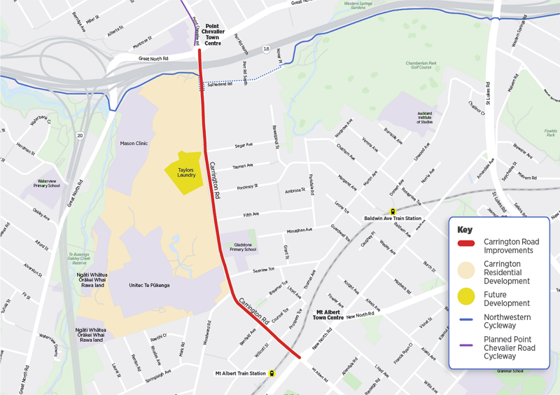
Carrington Rd is important for buses with two frequent services using it, the OuterLink and the 66.
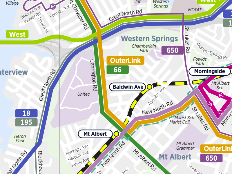
The proposed changes have been split into two key sections, north and south of Woodward Rd.
North of Woodward Rd
North of Woodward Rd, AT are looking to widen the road with bus/transit lanes and bike lanes. They are proposing to widen the corridor on the western side (along the Unitec campus / site of new housing), but the extent of widening and the layout is what’s up for consultation.
The key things they seem to be looking at are:
- Whether to install a two-way cycleway on the western side of the road or protected lanes on either side.
- If there will be bus/transit lanes on both sides of the road, or just northbound.
There are three options, as shown in in the following image:

- Option 1: a two-way cycleway on the west side of the road, a single northbound bus/transit lane, and two general traffic lanes – note the image also shows a central turning lane for traffic.
- Option 2: a one-way cycleway in each direction, bus/ transit lanes in each direction, and two general traffic lanes – and again, the image shows a central turning lane for traffic.
- Option 3: a two-way cycleway on the west side of the road, bus/transit lanes in each direction, and two general traffic lanes. Once again, there’s a central turning lane for traffic.
Here’s an artist’s impression of Option 2.
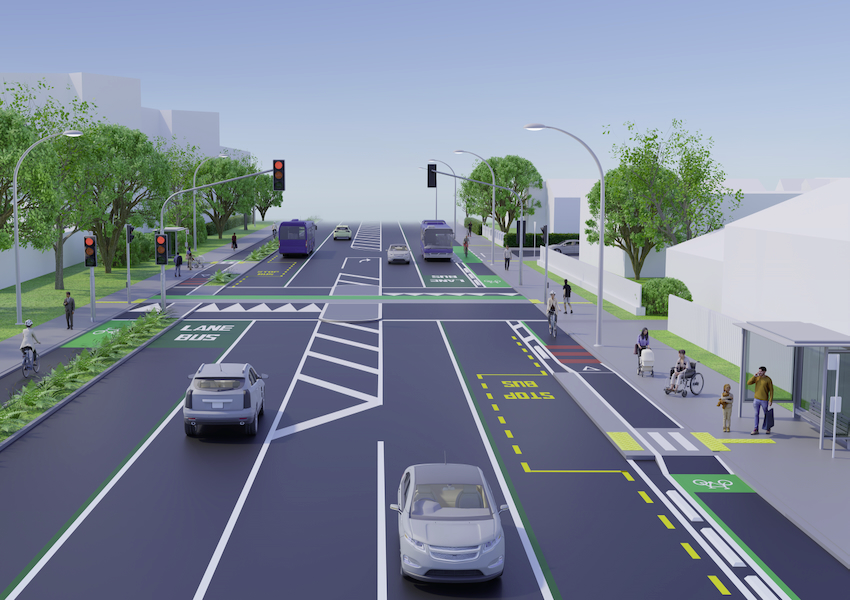
As you can see, it shows a road that’s five lanes wide, flanked by protected unidirectional cycleways adjacent to footpaths. This would be a significant change from what currently exists.
What’s not clear is how long this widened stretch would extend for, as at the northern end there is at least one section of protected building within the former Unitec site which prevents widening the road to the full extent possible.
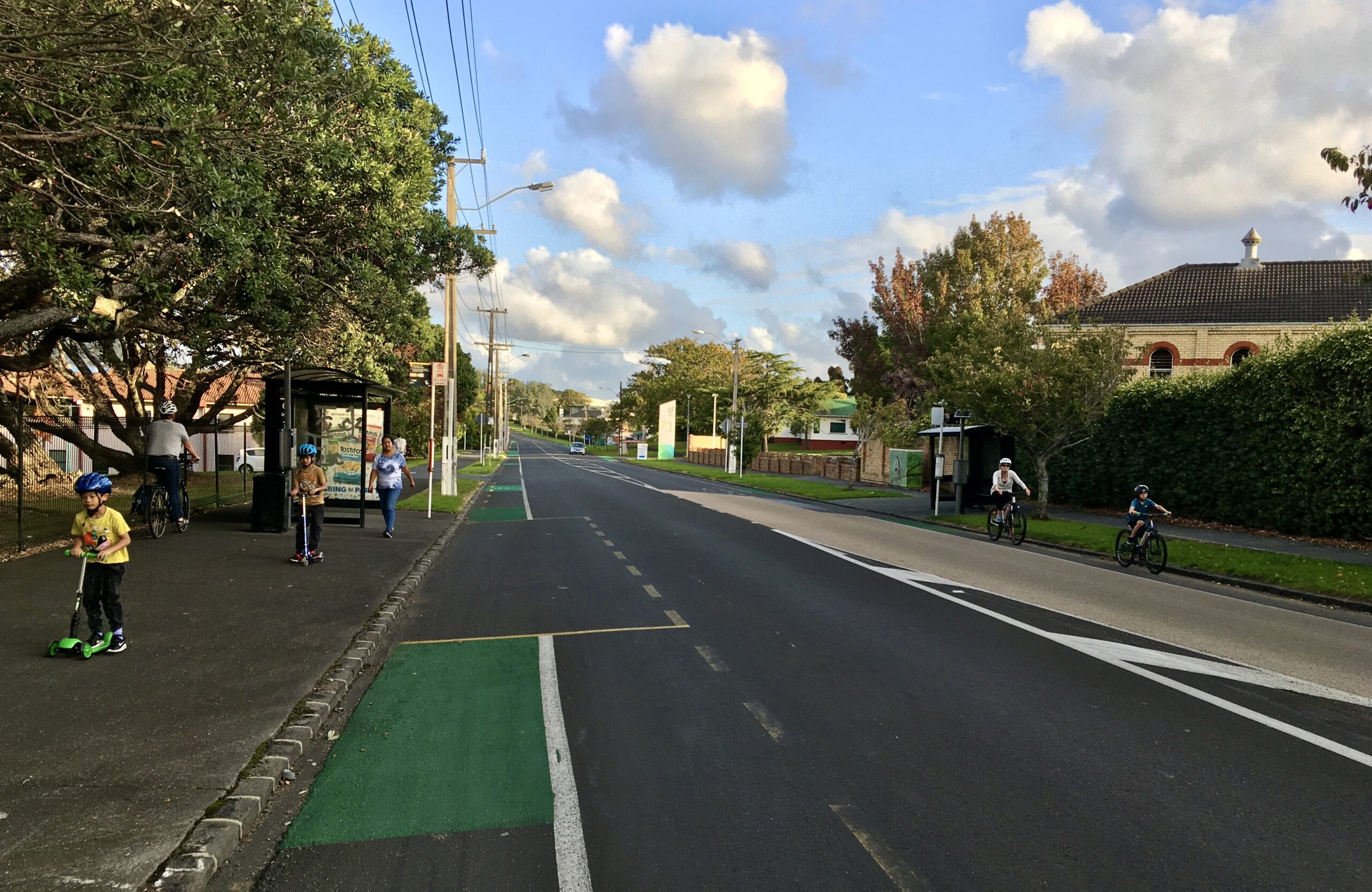
South of Woodward Rd
For this section, space is more constrained, and it appears AT will try to work within the existing corridor. (Probably because any widening would require taking a large number of homes.)
AT plans to make use of space currently used for on-street parking, to create a southbound bus/transit lane. However, it seems that lane might not be continuous, as they say they’re also weighing up whether to include right-turn pockets for side-roads or whether the space is better used for bus lanes.
They also say that while the rail overbridge cannot be easily widened for vehicles, they are investigating widening it for walking and cycling to improve access to the town centre and train station. (This is important given the plan to close the nearby level crossing that is used by people walking and biking, including the local school walking bus.)
The key decision here is the layout and location of the bike lane, which presumably will be tied to what is decided for the northern section. The proposals are for either a two-way cycleway on the east side of the road, or one-way cycleways on each side.
It would be really interesting to know how they plan to switch an east-side two way cycleway to a west-side one at the northern end, or how the one-way cycleways on either section would feed into a two-way cycleway. Ideally the route and intersection design would be intelligible and safely designed for the youngest users as well as regular riders.
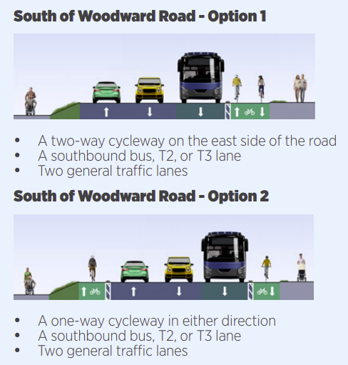
Here’s an artist’s impression of Option 2:

Pedestrian Crossings
In addition to the proposed changes above, AT are also looking at adding a few more traffic light controlled pedestrian and bike crossings, and replacing (moving northwards) the existing zebra crossing next to Sutherland Rd, which forms a key section of the Northwestern Cycleway and is used by many hundreds of people a day.
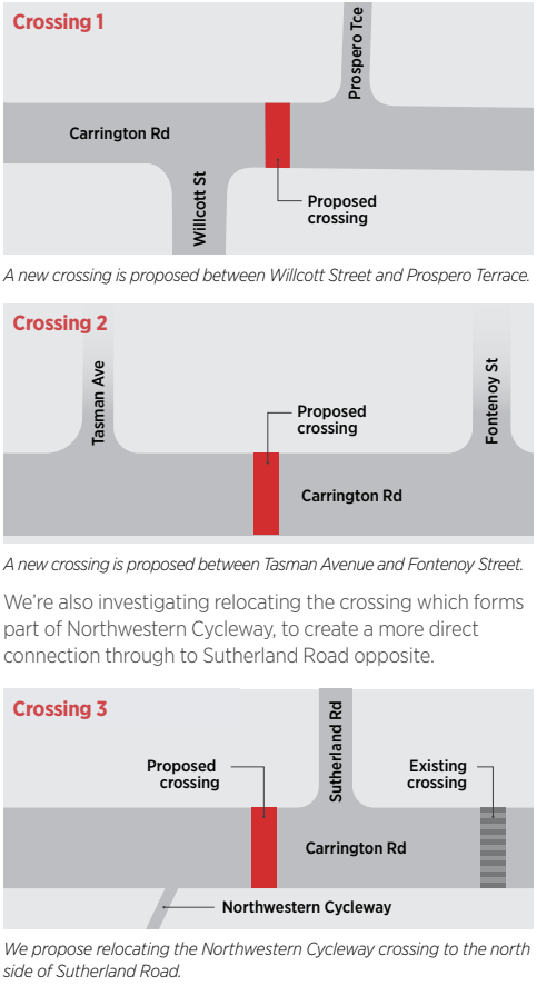
The Prospero Tce crossing is also tied to AT’s plans to close the Lloyd Ave level crossing, and the need to improve safety for people walking and biking through this section of Carrington Rd.
As for the Sutherland Rd crossing, AT says this is to create a more direct connection between Sutherland Rd and the NW cycleway. However, having to wait for the lights to cross what could be five lanes of traffic sounds like it has the potential to add additional delay to cyclists on the Northwestern Cycleway.

Hopefully this work also includes other improvements to the cycleway here, such as straightening out the connection from Carrington Rd to the cycleway through the northern end of the Unitec site. (The guest post from the other day shows a hint of that happening).
Sutherland Rd is also on a list of projects picked by Waka Kotahi for “optimising”, to improve travel choice for people in Auckland.

A few other comments about the project that AT note:
- There are likely to be additional traffic lights installed to enable safe access into the Carrington development site. The intersection with Woodward Rd may also have traffic lights installed. (How many sets of traffic lights will that make in total? Currently there’s just the one outside Gladstone Primary School)
- Where traffic lights are installed, AT are considering bus priority lights.
Where road space is more constrained, we’re considering the use of ‘bus priority’ traffic lights at intersections and pedestrian crossings. These lights let buses get ahead of the traffic and keep to their timetable.

- Stormwater improvements are planned and along with that, rain gardens and swales are also being considered – presumably this is only on the widened section?
- More trees are also being considered.
AT hopes to confirm a preferred design over the next year, with construction starting in 2025/26.
The consultation is open till 29 September. There are also a couple of drop-in sessions at the Gladstone Primary School Hall.
- 10am – 2pm on Saturday 16 September
- 6pm – 8:30pm on Wednesday 20 September

 Processing...
“Where traffic lights are installed, AT are considering bus priority lights “, how is this even up for debate,such low hanging fruit.
AT ,you know what cycleways work,(hint not bidirectional),well connected cycleways in each direction. Stop ” trolling ” the people you purport to represent.
Looks great and more importantly, looking forward to still talking about it in 15 years time.
Lol.
my thoughts exactly
Ultimately I’d like to see the NW cycleway having an underpass of Carrington Rd. The best way I can see to achieve this would be if the cycleway was built beside the motorway, and this would also ease the grade going over the Carrington Rd ridge, eliminate Sutherland St, the many mostly blind corners going through unitec and the dodgy bridge beside the golf course.
For Carrington Rd itself I’d prefer one way cycle lanes each side. The roads coming out of Unitec will be very busy and there are driveways on the other side. It is much safer to be riding in the same direction as traffic, and I think having a two way cycleway will have too higher risk of collisions.
Agree 100% – especially re the Carrington Underpass – as it and St Lukes have too many cyclists to not grade separate. Bus lanes I’d prefer one each way but honestly it’s more of what AT thinks is appropriate. You won’t need a southbound one at the Pt Chev shops etc.
Re the Mt Albert part, it’s not going to be great either way, as even if you make protected cycle lanes/dynamic bus lanes replacing the parking – you still end up at the bridge over the railway lines which isn’t ideal. In a perfect world they’d increase the height of the intersections around there, rebuild the bridge/extend the station exit – so you’d have a bus interchange with the station.
Agreed, the NW cycleway crossing is bad at Carrington Road. I think the easiest way to achieve crossing might be acquiring No.28 Carrington and putting a cycle tunnel under the road. As for Carrington Road itself, Option 2 north of Woodward seems a no-brainer. Couple of queries though, what happens at the bridge over SH16. Is that widened or remain the same? And what will the Carrington Road/ Woodward Road intersection look like (not an easy fix with driveways everywhere).
Why is there ALWAYS a big fat median strip in these designs stinking up the place and wasting road space that could be used more efficiently or require less widening
Because AT’s engineers and planners refuse to come up to speed, and are digging their heels in retaining a world dictated by traffic modelling.
Looks like they are proposing to use concrete tim tams. Better warn the incompetent drivers of the Upper Harbour Highway. They simply aren’t good enough drivers to safely navigate what this will become.
I’m flummoxed by the offering of mix-and-match options for the bike lanes. Bi-directional on the west side at the north end, switching to bi-directional on the other side for the south end? Or a melange of one-side/two-side the length of Carrington Road? And in any case, presumably it’s unidirectional at the bridges and intersections at each end?
If this is truly about improving travel options, why not start by making the bike and bus lanes as straight and continuous as possible – and then, as needed, zig and zag the traffic lanes to “accommodate” the most important modes?
Surely the bike lanes will linkup with the road improvements on Pt Chev road which has single lanes on both sides of the road .
Agree it makes absolutely no sense at all to chop and change sides of the road with bi- directional lanes
The idea of widening the northern end of Carrington Road (about a kilometre long) by taking a strip of Unitec land has been discussed for many years so it is good to see it getting closer. The existing road is a bit narrow so this will allow dedicated bus and cycle lanes. Concerns about the building just north of the pedestrian crossing being in the way are misplaced as the high heritage protection of the main (No. 1) building does not extend to all of the surrounding minor buildings which were added higgledy-piggledy over many decades – as far as I know that particular building is not particularly noteworthy and actually blocks the passing public’s appreciation of the northern facade of No. 1 building. As to the southern end I think that adding a new pedestrian/cycle bridge parallel to the existing bridge over the railway would be an excellent move – the existing footpaths and cycle lanes are very narrow and potentially dangerous. Long term AT would like to be able to have a bus stop right next to the train station entrance but when they investigated this about 6 or 7 years ago found that it would be more economical to replace the entire bridge than add a bit of deck for the buses – so too expensive for now. I am quite open to either solution for cycleways (two one-way lanes or bi-directional) but suggest that we go with what the cyclists themselves prefer.
In the time that it’s taken them to get around to doing this corridor, the world changed:
– The planning understanding changed; we know now that widening is not necessary and that in fact the two ends of the widened section will simply become the next pinch point leading to a demand for further widening.
– The evidence about road reallocation and bus gates and low traffic neighbourhoods changed; we know now that we can reduce VKT sufficiently to improve bus journeys without having to give buses their own lanes on arterials like this one.
– The understanding about emissions changed; we know now that halving VKT by 2030 is critical to our future, and that widening every arterial like Carrington Rd is counterproductive, and wastes money that should be being put to emissions reductions.
– The understanding about safety changed; we know now that severance of extra vehicle lanes ruins the permeability of the area for people on foot and bike and fundamentally reduces safety.
There’s a better design for this corridor, but AT management are so car dependent they won’t be open to hearing it.
This looks relatively modern in design, single direction bike ways are definitely preferable, and there is good protection for pedestrians. Of course the question is how the cogs rotate, but as important infrastructure would definitely be a positive to pipeline for any downturn in construction. This could be considered climate resilient infrastructure and potentially allow for light rail at a later date if the bus ways are properly installed. Hashtag learn from the Northwestern motorway debacle.
It is amazing how long this drawings came up for the consultation as I was one of the draughtsperson who drew up the proposal plans about 8 years ago.
Looks good. Not sure which of the options are better without an in-depth study.
Actually, for starters, the one way cycle lanes each side is the best.
In addition to the details provided here, I’ll also introduce you online. This is a very nice list of the games I’ve played, which includes some of my all-time favorites and most well-known titles. another subject. Different games that I bet you’ll like.
It looks like AT haven’t spoken to the Ministry of Housing and Urban Development (owner of site on behalf of the Crown) and Mahuratu and Ockham (developer of northern section of the site) as they are proposing to move the cycle path as part of the redevelopment plans. That would see the new crossing they are proposing not aligning with the new path.
From action-packed shooters to classroom 6x mind-bending puzzles and immersive role-playing adventures, there is something for everyone.