While plans for Auckland’s Rapid Transit Network have existed in various planning documents for a long time, the routes and modes that make up the RTN have evolved a number of times over the years. The current iteration is just over five years old and was a part of the second Auckland Transport Alignment Project (ATAP) that was launched in April 2018. Where previous versions, such as the one from the first ATAP in 2016, highlighted high-level routes, the ATAP 2.0 version took things a step further by suggesting modes.
However, it hasn’t always been clear if any analysis has taken place to inform that future network and there’s been very little, if any, work done to assess when some of the routes may be needed, or even if additional routes are required.
To address this, AT, Council and Waka Kotahi have been working on a draft Auckland Rapid Transit Plan (ARTP) for the last three years which is intended to put some more rigour behind key RTN decisions likw mode and sequencing, bridging the gap between high level plans such as the Auckland Plan or ATAP and specific projects. Yesterday the AT Board were asked to approve sending it to the council for endorsement.
The paper is keen to highlight that the plan is not about locking the design of the RTN in stone but is “Auckland’s views of what is best for Auckland” to serve as a useful reference point for discussion, advocacy and negotiation with the government. For corridors where more detailed planning work hasn’t started yet, it also helps by providing a starting point to build off of.
The plan is not a definitive, locked in position on mode, timing, alignment etc. Instead, it is a reference case – a starting point for future investigation through individual projects. It highlights the regional view, to be tested at a corridor view. It will be updated as each decision is made on an individual corridor basis, including government decisions on funding, and technological advancement. Its core value is in having an agreed starting point and indicative end goal. It is already providing this role informally, but it is time to have a formal recognition of the network plan, together with public openness on the planned way forward.
AT say:
The Auckland Rapid Transit Plan’s network was developed through progressively answering the following questions:
- What rapid transit corridors are likely to be needed in Auckland over the next 30 years?
- What is the likely mode for each corridor to be used as the starting point for future business case development?
- How should delivery of the rapid transit network could be sequenced over time?
- How can we manage uncertainty about growth patterns and future demand levels?
- How can the various agencies responsible for the delivery of the network work together to achieve the best outcome?
This is what they came up with. Unsurprisingly, it is very similar to what we have seen before with the biggest difference being a bit more uncertainty with the cross-isthmus corridor – though some combination of all of them looks great on a map.

They note:
This network will be progressively implemented over time. This includes at the corridor level, where in some cases interim upgrades should be made ahead of longer-term investments or where some sections should be built ahead of others. Interim upgrades may include introducing bus services ahead of investment in another mode, or temporary infrastructure to enable service improvements ahead of more significant investment.
Some thought has been put into how this would be staged too, though there is no timeframes around that. They also note that some of these corridors might originally be delivered as interim upgrades, like is happening now on the Northwestern.

To come up with this network, the work assessed a range of different corridors and across a variet of objectives. This resulted in confirming the network above but also highlights the likely next routes that might be added, being Onewa and Glenfield Roads, Manukau Rd, and Pakuranga Rd.
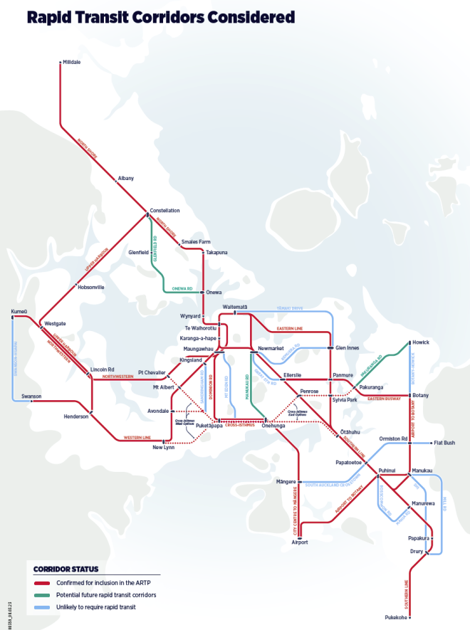
It’s interesting in there is that Sandringham Rd is listed as being “Unlikely to require rapid transit for the foreseeable future” when that’s the route Auckland Light Rail are planning to use for their tunnel.
To come up with the mode options, AT have used these figures of capacity per mode.
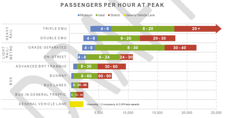
And they have combined that with the modelling for the various corridors. Personally, I think the suggested outcomes for some corridors doesn’t feel quite right and that may be related to limitations in the modelling, which probably struggles to properly pick up the transformational nature of projects like the City Rail Link.

Finally, one interesting aspect to any planned RTN is the impact it will have on land use. This is because the National Policy Statement on Urban Development (NPS-UD), which requires significant upzoning around rapid transit stations.
The Plan also notes how the RTN is strongly aligned with development areas identified in the Auckland Plan.

As well as noting the need for good access to any new stations, the plan also notes that improvements are needed to existing stations and that AT are currently working on a business case to deliver them over a 10-year period. The basis of this comes from a Rapid Transit Station Access Study they have already undertaken.
Auckland Transport have assessed existing station access and experience across the rapid transit network, including an analysis of existing facilities, customer experience, the ease of transport access and the land use around each station.
It is great to finally see this plan emerge, as the logical overall network picture has clearly been missing from work undertaken on Auckland Light Rail and Waitemata Harbour Connections projects. It is interesting to see some inconsistencies between this work and more recent announcements on those projects. The rapid transit plan is a welcome insight into what’s right to do when you actually take affordability into account and think about what’s needed right across Auckland, rather than for a single project.

 Processing...
Great. Now we just need $50b or so to get cracking
If only there was a cheaper way than what the government was proposing. Oh well, back to digging that huge car tunnel.
The Tamaki Estuary is the final frontier to connecting East Auckland to proper rapid transit.
Time to start making it a dotted line. If we can endlessly duplicate the North Shore links with hugely expensive tunnels, is it really so preposterous?
Thankfully there appear to some grownups looking at this. To just take one example:
A glance at a map of the Isthmus and it is obvious that Dominion Rd goes right up the middle of the basin. So it is clearly best placed to attract ridership on a higher-order service from the whole area. It already has the highest bus ridership of the three parallel mains roads into the City Centre and is equidistant and close enough from two others to attract users, esp if we improve crosstown bus patterns.
Sandringham Rd is not only at the extreme edge of the catchment but compete with the existing rail line for riders.
Eventually with RT on the Western Line, Dominion Rd, Manukau Rd, and the Southern line all connected by crosstown bus services with good frequency, the job will be done.
Along with the rest of the plans, we’ll then at last have a much more liveable and equitable city.
I presume that amongst “INTERIM” projects, “Liberate The Lane” can be implemented.
This is a very low cost improvement for North Shore Residents, and some of us South Shore City Dwellers, that would not mind free access over a bridge that my ancestors paid for with taxes and probably a few of their lives. It would seem respectful that we allow non fossil fueled powered beings to summit the bridge as they wish; we are already protect our Maunga from the scourge of “Ram Raiders” (car drivers).
One quarter of the capacity of the bridge is very little to ask for, as Bike AKL have very carefully priced and calculated.
If Auckland Council and Auckland Transport are truly interested in austere economic solutions, then letting people ride their bikes everywhere could be borrowed from Cuba 1989, which was a far more austere place to be than here in 2023.
Glad to see the ludicrous north shore devonport/takapuna/etc tunnel plan does not feature on this.
Only looking 30 years. More thought on new pop. By then can shape where North Shore and further north RTN will be needed.
Plans, business cases and public engagement. Rinse and repeat for another 5-10 years.
Construction … yeh nah.
A plan on top of a plan which has 5 other different plans for the same purpose.
Assuming National get in for another 9 years which is looking likely, then you can throw away anything with the word rail on it.
Apart from “Back on (bullock) track” or ‘railroaded.
Also, I love when I see “the busway can be converted to light rail at a later date” which you know will never happen as once its a Bus way its going to stay that way. Kiwi logic at its finest
I know it’s a schematic map but that dotted line from Sylvia park to pick a ring a suggests using the Waipuna bridge. I’ve long thought this is a good idea. This would make competing with the car this way a lot more competitive. It’s too long a deviation via Panmure.
I was pleasantly surprised by that one. Hadn’t seen it on other plans and it links up some sizeable employment and transport hubs.
*Sylvia park to Pakuranga
Doh autocorrect not notice. Yes could be carbine road side of course or even another bridge.
I’ve always wondered why don’t any buses use the Waipuna Bridge to connect between Penrose, Sylvia Park and Pakuranga/Botany?
Surely this would be a useful route to connect Pakuranga/Botany to alternative train stations than just Panmure.
The buses can use Waipuna Road & Musket Place/Lynton Road to get into of Sylvia Park and once they build the proposed bus road from the Sylvia Park Road intersection through to Te Kehu Way it will be a lot easier to connect through to Penrose station via Sylvia Park Road and Great South Road.
Alternatively, the bus can come in via Carbine Road, Clemow Drive and enter the mall via the proposed bus road and then exit via Lynton/Musket onto Penrose Road to Penrose station.
Yes, lots of possibilities. I guess the Eastern Busway made them think along Waipuna Rd was not needed but it’s quite a different thing.
One idea I had was a connector service (1/2 hrly generally). From Pakuranga to Onehunga, but different to the now frequent 74 route in that it should use (coming from Onehunga end) Neilson St (now currently without a service), Church St onto the SE Highway for a small section, Carbine Rd (improved walk etc access to Sylvia Park Train station), Waipuna Rd/Bridge (currently no service), Pakuranga Station/Plaza.
Sure there is sections where you can’t have bus stops but it should be pretty fast and fill in a void of service with a stops around Waipuna Hotel & near Finn Pl (near the bridge) giving coverage for the Hotel, basin reserve & residents in general. The Eastern Busway originally planned to have a stop near the walk bridge from there to the Panmure side (Church Cres) but was dropped. Carbine Rd stops would connect with the 323 service. Stops around Mount Smart Stadium give an obvious connection there and transfers with the 670/74 bus.
Meanwhile, the existing Eastern Busway plans currently physically blocks this bus service pattern from happening. A cooker anti-futureproofing choice there.
Be a bit non streamlined flow, but I think it can work with the busway plans. Towards Pakuranga may have to hang a hard right via Palm Ave / Aylesbury St Intersection to get into the station.
Plans and plans never ending plans different coloured squiggles and dashes that’s all it will ever be nothing will happen but another plan nothing wrong with dreaming be better if they all woke up and rang the man or women with the digger and the concrete truck and just got on with it whatever it is their trying to do
Meanwhile Simplicity is building 340 long term rental apartments in Ellerslie that will do more for emissions reduction, cost of living, more use of Greenlane station and reducing congestion.
Simplicity is leading the way and if the city just built more apartments in Kingsland, Newmarket, Ponsonby etc then there would much less need for more roads to the suburbs and could save our city $billions.
Yes indeed.
The comments on the Herald article say: “Traffic management/parking been considered? Upgrading the original main services (sewerage/electricity/stormwater/wastewater) to accommodate all these new dwellings? probably not.”
Why are north shore suburbs like Birkenhead, Birkdale, Glenfield etc completely missed out when Takapuna, that is relatively sparsly populated, gets light rail and many other locations like Henderson and Westgate get buses and rail.
Yeah, that lower North Shore, in between SH1 and the UHH looks barren. I would have thought there would have been an east-west link of more urgent need.
You need to read this RTN along with FTN. I have barely enough time to write this between city and Beach Haven on bus.
Where the hell is Puketapapa? Never heard of it. Surely they aren’t referring to Mt Roskill?
A quick search on Maps shows something called the Albert-Eden-Puketapapa Ward, and a Puketapapa Street, which is near Richardson Road. Hope that helps.
Puketapapa is the Maori name for Mt Roskill, much like Mangawhau is Mt Eden.
It’s been the name of the local board since the super city began.
Quelle surprise. National will scrap the Community Connect Concession.
https://twitter.com/RichardHills_/status/1696668073493926249
One thing that needs to go is the term (light rail) everytime I hear that term it gives me anxiety due to how dogged the project has become.
the term heavy rail needs to go also, these terms that suggest the weight limit on the track mean almost nothing, heavy rail should for now on be called (main line rail) meaning that it is part of the national freight and passenger network. And just get to the point and call light rail what it is, it’s ether a tram or it’s a metro.
Why the constant fascination with “light rail”. Any tram I have ever been on overseas what in heavily populated areas and presumably the next step up from buses. Regional trips, like from Milldale to CBD need to be heavy rail with minimum speed of 100kmh, not light rail trundling along at what – 70kmh?
Yes I totally agree with you,
I wouldn’t want to sit on a
Tram doing 70 km/h from Silverdale to the airport, even if it did pretend to be a metro, stopping at stations 1 to 3 kilometres apart, it would still be ridiculously slow.
But I’m not sure what you mean by heavy rail? You mean extending the main line over the harbour to milldale or a separate high capacity metro system?
There won’t ever be a need for a 2nd main line system heading north as there is already one heading north to Whangarei.
I guess you are a bit on the wrong boat then. Silverdale to the airport is just not the highest priority as the region goes. Some areas just aren’t as well suited for PT, especially high-capacity / high speed. I moved to a rural and while I regret a reduction of suitable PT as part of that choice, I am not expecting someone to build me a train to pick me up and whisk me away to catch a flight. Other links are much more urgent. And in this game it means that I (and Silverdale) will never get competitive, high speed, high capacity PT in our lifetime. So it goes. We’ll be lucky if the areas 20km out from the centre get it by then.
And for what it’s worth, for some trips reliability is more important than speed. If you KNOW that you will arrive by X time, the savings between a light rail doing 60kph average and a train doing 100kph average become less important.
I thought light rail could do 100km/hr. However, 70km/hr would still be almost twice the top speed of the Western Line….
I don’t think I’m on any wrong boat, yes places like Silverdale and Kumeu, may be 50 years away from rapid transit but it would be extremely stupid to build expensive infrastructure like rail tunnels through – under the CBD or bridges over the harbour and not think more then 50 years ahead.
Yes the typical trip won’t be from the north shore or north west to the airport, it may not even be to the CBD but there will be places for all types of rapid transit including trams for those shorter high density corridors.
Light rail/metro systems can have top speeds of around 115km/hr, what’s this 70 km/hr?
referring to trams not metro.
Abd by trams you mean light rail.
The terms heavy/light rail are used quite ubiquitously and gives an indication of the type of rail vehicle (train or tram) and capacity (among other things) passengers can roughly expect so these terms do confer some-albeit high level-meaning
Yeah, but I doubt anyone in places like KL stop and think that in the course of one commute they might use light rail, light metro and heavy rail, if they transfer between these lines. The all interact together as part of the network.
People just say, ‘I take the train”.
I’m thinking more from a planning perspective (especially in a western context). “Light rail” usually comes with certain expectations/features like lower cost,potential street running, lower capacity and speed and worse ride quality.
I would think that if the dominion road surface line got built I would imagine people would say “I caught the tram in”
We have an office on George St, Sydney, and no one I know that uses that surface light rail there calls it a tram. The folks in Melbourne use that term though, for obvious reasons.
In Istanbul right now sat inbetween the historic tram and the new tram and everyone; locals, visitors and staff, call them both trams. The metro nearby is called the metro officially but everyone calls that the train.
Off to catch the high speed train to Ankara tomorrow. Can only dream regular trains between HLZ and AKL (instead of two a day) and as for the rest of NZ, it’s not even a dream, sadly, especially for Taupo and Nelson.
My main point is that the Auckland light rail project has been extremely problematic and has also become very political, so it’s looking likely that national will be in and the project cancelled.
But I’m confident we won’t see the end of it. I would just hope that they don’t use the ALR branding to help distance any future proposal.
Yes the rapid Transit Corridors Considered IS interesting.
“It’s interesting in there is that Sandringham Rd is listed as being “Unlikely to require rapid transit for the foreseeable future” when that’s the route Auckland Light Rail are planning to use for their tunnel.”
Perhaps that is the reason why Sandringham Road will not need additional Rapid Transit, if there are already plans to put a tunnel full of RT under that very route? It’s a bit presumptuous to count it as already done, I agree, but great to see some optimism!
One thing I would like to see is a chart similar to the mode capacity per hour above, but also show the average operation costs per passenger km traveled at different capacities.
This would help lay people understand why you wouldn’t just keep chucking more buses on to increase capacity past a certain point and where a tram would cost less in the long run.
Also helpful would be minutes along route between interchanges, to recalibrate the scale of the map.
Yeah bro.. we need to get rid of the bus lanes an put in an electrified light rail.. an we need more stations.. you can build train lines on top of the highways with sky bridges and then have light rail off it that cars can comute down to an you can programme it so that every intersection is a stop or hop on point.. im pretty sure there are alot of volcanoes underground making tunneling a challenge.. none of this bus lane crap taking up road space yo.. look to melbourne and calculate the distance between different lines.. you can’t have them so spaced out.. you need to build housing more dense an go higher an have more facilities.. you want to design a system that can accomadate a certain number of population before you even have that population.. then you can stay a head.. so lets say auckland is 1.6 million pop.. you want to be able to build a system that can support 6 million population.. otherwise your limiting your potential growth in the future an property prices will be affected an you will forever be playing catch up.. also we can’t be doing something that takes 30 years.. that is far to slow.. hire overseas help from the likes of China.. an do it in 5 years.. 30 years is to long most people working on it will be retired by then an new people wont be as passionate as the world outside this city modernises further at a fast rate an new ideas come to life.. we need to get this job done as fast as possible.. an we need to build a high speed rail throughout the country.. a 350kmph rail that can take you anywhere.. this will make the place less boring as people can easily go from a to b and it will reduce crime.. because there will be a lot more to do an people will be proud.. imagine being able to go from anywhere in auckland to the spots along the coromandel for a surf then to ruapahu for a snowboard then back to auckland all in the same day.. without having to worry about driving because you can rely on transport.. also if you have electric pedal assist government bikes for rent at each station an have docks for them around the place then you will be able to move more freely and it will faster then commuting in a car and you will always be on time.. we have a high enough GDP to support such a system.. theres countries with far less that have far more.. it doesn’t cost much over 5-10 years.. if you just focus 20 billion each year on that.. then it will be the best tax payer money ever spent.. your over pricing the cost of alot of these projects in the papers.. i know other countries who do them for 5% of the cost.. stop doing these projects to make your friends rich.. do it to better the nation in a not for profit way.. because you will profit it off it later.. the construction companies dont need to profit that much from it.. a huge project like that.. 1% profit should be more then enough.. thats a billion dollars over 5 years..
That’s a pretty fair and visionary assessment of what we need.
Some communications from AT summing yesterday’s meeting include this on the Auckland Rapid Transit Plan:
“There was discussion on delaying the endorsement of the plan until the October board meeting and post-national elections to allow for further work with Waka Kotahi teams to update the plan.
“Decision: The Board agreed to reconsider the plan at a future meeting once further work has been completed between AT and Waka Kotahi.”
Lol. What should we call that?
Pragmatism
This may be considered ‘off topic’, but I don’t think so-Anyone interested in transport infrastructure design, particularly that in urban areas, needs to consider this matter- I use a wheelchair and I want more bike lanes EJ Barrett Guest writer- link https://thespinoff.co.nz/society/24-08-2023/i-use-a-wheelchair-and-i-want-more-bike-lanes
Go figure.
Something needs to be done now to stop the wasted money on Auckland public transport, otherwise if someone comes along and chops out the buses that almost run empty, that is going to make the system less trustworthy for public transport users and have a flow on effect to other public transport to make people use their car..
system.
With news 2019 on the latest budget blow out on the underground rail project between Britomart and Mt Eden Just so train users out west can save five minutes on the train while motorest going over the bridge have to go on waiting list at peak travel times of the day, with shrinking rate payers and growing rent payers, not too mention public transport users we will all have to pay for it one way or another. If someone can save money using more efficient uses of buses and trains without cutting services, any idea should be improved on.
One suggestion to pick on the north-shore for example is to keep the rush hour workers buses the same until or unless cheaper improvements can be made without making workers worse off in anyway for getting to work on time.
At the moment there is
NX1 buses going between Hibiscus Coast bus station & Albany to Britomart.
NX2 buses going between Albany and Auckland University of Technology & Auckland University, (however we
have to be careful with the NX2 as I have noticed it is often near full throughout the day.)
PROBLEMS:
Sometimes I have noticed while on the NX1 bus between Hibiscus coast to Britomart, as the NX1 gets into Albany bus station, The NX2 bus is just leaving, there is no way to get a direct transfer, without having to wait at the bus station for the next scheduled NX2 that could be as much as 15 minutes.
The Sunday #981 bus between Hibiscus coast bus station & Orewa,
The latest 24th January 2021 timetable shows that the #981 on Sunday comes to a abrupt end at 7:45pm, while NX1 buses keep leaving Hibiscus coast station to Auckland CBD until 11.05pm.
The strangest thing about it, there is half hour buses needed for phantom Sunday rush hour passengers for most of the day.
The #981 & #984
Based on the previous “phantom Sunday rush hour passengers” paragraph. I am sure they could alternate times between the #981 & #984 each half hour on Sunday and there would not be too much hardship compared to how it would look if no buses ran at all, due to lack of money to run the buses from very poor or zero passenger numbers. Someone who just missed the #981 bus on the bus route only the #981 goes along could very easy walk to a bus stop that only the #984 goes on and catch the bus half a hour later.
As I use a NX1 and it travels between Akoranga bus station and Constellation bus station along the “Northern Busway”. I can not help but notice the frequent almost empty NX1, NX2 buses coming the other way. I have to ask “Could there be a more efficient use of buses between 9am to 3pm weekday outside the rush hour times, ultimately to save money” like having a “busway link service” similar to the four different link buses that operate from Auckland CBD that started with the dollar a trip inner link bus. The busway link would go only on the busway route. Akoranga bus station and Constellation bus station(or better still to Albany bus station), lets call it for this example NX-link.
So between 9am to 3pm a NX1, bus only goes between Britomart and Akoranga bus station, The NX2 between the two universities and Akoranga bus station. The #866 could be replaced with for this example NX866 and only go between Newmarket and Akoranga bus station, no doubt there could be many more NX? options tried out going directly to other parts of Auckland, such as the Museum of transport & Technology and the zoo in the
weekends, just to give one destination example.
Go to https://tracker.geops.ch/?z=13&s=1&x=19446649.8366&y=-4385812.6254&l=transport
or go to https://tracker.geops.ch , zoom out of Europe and zoom into Auckland city
Sooo….all the buses are empty except when you use them? Lol
It is time for a major re-think and bigger picture perspective.
Auckland has major growth constraints given its harbours and narrow isthmus; given this plus the fact that the CBD and surrounding areas are just fetid dumps, why do we always assume that everything & everyone has to be connected to the CBD?
Go across Europe and see how the human race developed over the last thousand years or so – people lived in villages surrounded by their source of livelihoods. Big cities were a construct of the Industrial Revolution and all the miseries that came with it.
We have plenty of space for regional development with access to ports like Whangārei and Tauranga; a golden triangle could exist between Auckland/Hamilton and Tauranga, connected with a rapid rail system and affording new industries with connectivity and better lifestyles for their inhabitants. The new Sleepyhead concept in the Waikato is a brilliant example.
Time to think outside the square.
interesting, it looks like AT and AC have cancelled the southern growth zones.
The land down south blends into the Manukau harbour. Its like the “nothing” has arrived.
Sometimes you wonder whether they should make a Mangere/Airport line from the existing HR line to Onehunga. If we are building bridges, elevated rail we may as well do it for the max capacity mode.
Involves double tracking Onehunga line, but corridor is there already. Close most of the level crossings. Potential to create a Mt Smart station alternative alignment perhaps in the future.
Stick to the SH20 & 20A corridors. Have good access to stations in the surrounds.
Western line runs all trains via CRL to Airport. Less wastage of Newmarket to Penrose section of the network as you now have a whole heap of catchment now running through here.
Fast frequent, reliable.
Isthmus & future NW & north shore upgrade could be light rail/metro.
That was the plan (they even designed the new motorway bridge for it) but NZTA kneecapped it by only providing enough space for a single track. Whether it was incompetence, confusion due to the Onehunga line being single track, or just the designers not caring, it means that using heavy rail would either have terrible frequency or require a new bridge across.
Then they did a shoddy business case study that said light rail was better (sure the way they calculated it was borderline criminal), so they consider the matter dead and buried.
Personally my view is an automated light metro of some kind, as the OPEX of drivers in the future (not to mention strikes/safety) will either be unaffordable, or we won’t be able to have 24/7 service and reasonable frequencies. If light metro ends up using our narrow gauge, it might add some complexity but also allow some equipment to be shared between the new lines and existing ones.
Either way, it’s a great corridor, and they should figure out the overarching goals before deciding a mode first.