Trying to get across the harbour by bike or on foot has been a long and frustrating saga. In recent years we’ve seen the citizen-led Skypath proposal get all the way to resource consent in 2016, only to be replaced in 2019 by a Waka Kotahi concept for a walking-cycling addition to the city-side of the bridge (which turned out to be unbuildable)… followed in 2021 by an out-of-the-blue proposal for a dedicated walking and cycling bridge (which was quickly shelved after unfavourable coverage about the cost).
More recently, advocates have begun to put the focus on the simple, straightforward and more affordable idea of using available space on the bridge – aka liberating a lane.
To that end, our friends over at Bike Auckland have just released an independent report that investigates the engineering feasibility of converting a lane on the harbour bridge for active modes.
The TL:DR version, it’s totally feasible, can be safely and quickly implemented, and would have less impact than previously claimed, due to changing travel patterns. Bike Auckland says:
Engineering Report Confirms: Walking and Cycling Lane on Auckland Harbour Bridge is Safe and Viable
An independent engineering report commissioned by Bike Auckland was released today and confirms that one lane of the Auckland Harbour Bridge can be safely allocated to pedestrians and cyclists without significantly impacting traffic flows. Link to full Smartreport here.
The report was authored by Richard Young of SmartSense Ltd, a Chartered civil engineer with over 35 years of experience in infrastructure design, construction and maintenance.
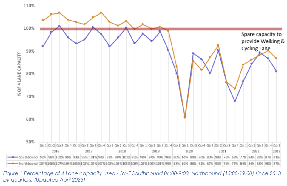
Using traffic numbers from Waka Kotahi stretching back to 2013, the SmartSense report concludes that the bridge can support current peak traffic demand with one of its eight lanes repurposed for active modes.
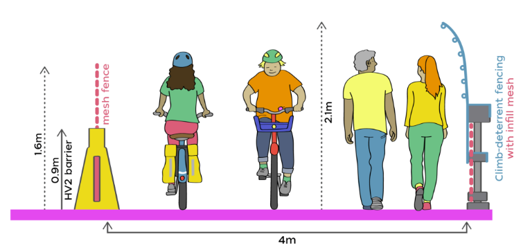
The report also proposes a practical design for a four-metre-wide lane for biking and walking, which addresses numerous safety concerns raised publicly by Waka Kotahi. The design includes a free-standing crash barrier which is approved by Waka Kotahi, and an unobtrusive anti-climb system used on comparable bridges overseas.
The report also concludes:
- The Auckland Harbour Bridge is no steeper or longer than many shared paths already provided by Waka Kotahi, some built as recently as 2022.
- Weather conditions would be suitable for 98% of the year, meaning an active mobility lane would be affected by adverse weather conditions at roughly the same rate as other bridge traffic, around three to seven days per year.
While lateral movement has been identified as an issue when two adjacent clip-on lanes are used in mass pedestrian events, this is not a concern with the proposed design. The SmartSense proposal only uses a single lane, and predicted pedestrian numbers are well below the level identified by Waka Kotahi as triggering the effect. Moreover, Waka Kotahi has had engineering solutions in hand to mitigate this effect since 2010.
“The SmartSense report shows that a walking and cycling lane over the Auckland Harbour Bridge is safe and viable,” says Bike Auckland chair Karen Hormann. “An active mobility lane could be rapidly delivered at a cost of only $30 million, and up and running within 8 months.”
“All major harbour cities have ways to walk or bike across the water, to the benefit of locals and visitors alike – think of Sydney, Vancouver, San Francisco. Meanwhile, Aucklanders have watched, waited and despaired for decades as plan after plan for walking and cycling across Te Waitematā has been proposed, picked apart and then cancelled.”
“This is the fastest, fairest and most affordable way to bridge the gap between the North Shore and the rest of the city. It’s time to get on with it.”
 As for the design,
A safe design would include:
- A shared path for active modes located on the most easterly clip-on lane. The east side provides for better protection from wind (predominantly Westerlies), easy access on and off the bridge, and stunning views of the harbour and city
- The use of free-standing HV2 Steel/Concrete composite barriers with mesh fence between the shared path and the motor traffic. This is a relatively lightweight barrier which Waka Kotahi has already approved the use of in Aotearoa NZ
- An anti-climb barrier along the eastern edge of the bridge for suicide prevention, as has been effective on comparable bridges overseas
- Potential for a 4metre shared path width which is within the Austroads guidance for gradient (5%) and width with the expected usage
- Potential for dampers to be placed between the bridge and the clip-on (to prevent movement caused when a significant number of pedestrians march across at the same time)
- Potential for a 60km/h speed limit for the motor-traffic in the lane adjacent to the shared path for additional safety if considered required
Since COVID, traffic volumes across the bridge have dropped and data from this year shows this drop has been sustained, meaning the impact of liberating a lane is much lower than it previously would have been.
There’s a lot more detail in the report for those interested.
Let’s get on with it and liberate the lane.

 Processing...
There have been two options that offered certainty in commuting times in Auckland for me. Biking and the train,( the train is much less reliable now). Once l decided to commute by bike,my commuting times were only dictated by the effort,l was prepared to make.
My “to work” commute would have been quicker by car (15 mins against 25 mins),but “from work” (45mins by car ). This commute included a Harbour Crossing, Manukau, which was an unavoidable bottleneck by car.
A lot of this commute was done on the now disused Mangere Bridge underpass,with its 24/7 security guards, which l was grateful for. This of course has now been replaced by an excellent ,walking and cycling bridge,cost around $39 million,taking 2/3 years to complete. To be able to walk/cycle across the other Harbour,Waitemata, with an option that would cost less, and be completed quicker,than it’s lesser known “cousin ” is news that the relevant authorities will surely be interested in.
Well done for Bike Auckland for keeping up the pressure on this. Is it cynical of me to think that only a Labour government reliant on the Greens will be arm-twisted into agreeing to this over the opposition of Waka Kotahi?
Or a Green government reliant on Labour :0
🙂
Sounds like a no-brainer when you put it like that.
But now wait for the excuses to get rolled out. My prediction is we’ll be having the same conversation in 2028.
Although I would love to have some way to cycle / walk over the harbour bridge this report does seem to be at odds with the Beca report for WK.
I thought the clip-ons are 9.8m wide each, with 3.5m marked lanes. Having a 4m wide path plus broad buffers and barriers either side seems to take out more than 1 lane.
Whenever someone uses the term no-brainer it is a often a way to shut down debate.
Can you run me through your calculations on that?
9.8m cf 4m + 3.5m seems to leave 2.3m for ‘broad buffers and barriers’.
What does the Beca report say?
Hi ‘flyde’. As the report’s authors I’m not sure you are referencing a report that is relevant? The shared path / traffic lane widths proposed are actually those quoted by the Resolve Group for a WK (Option 3) ‘AHB Shared Path Options – Interim Findings released under OIA and the 2020 Single Stage Business Case (p18 & 22).
Page 8 of the full Smartsense download report shows cross section if you want to have a look. 4,700mm inner measurement for general traffic would include the shoulder breakdown bit of lane and then shows 4000mm shared path lane (inner measurement), so plenty of space for barriers etc.
The problem with WK is that they didn’t ever want to do this and just found problems which they then decided were show stoppers. If they had the mind set of we want to do this, now lets solve the problems they could have come up with this plan. I have no doubt that WK will now come up with many more problems as to why this plan can’t be implemented.
Great post. Thanks to Bike Auckland.
This has been, and still is, one of Waka Kotahi’s most shameful episodes of blocking what Aucklanders need.
Liberate the lane is a good tactical shift.
It calls out WK’s obstructionism hard.
So disappointed how many people fell for the obvious strawman that was the WK walk/cycle bridge.
At least the media and political right had fun beating on that defenceless lump.
Oh yeah, I forget about e-scooters when thinking about the smidge of the bridge for active travel. Is it feasible for e-scooters to go from say Takapuna to City i.e. do they have the range?
Yes they do. Mine has a range of 40km, and it can charge with regen braking on the way down the other side of the bridge
whoops this was meant for Matthew – apologies!
Jakey, we need to
1/ Liberate the Lane
2/ Reduce VKT by half, by 2030
3/ Stop piling the cost of expensive carbon-intensive projects onto our children
4/ Vastly improve public transport offerings.
Where the walking and cycling bridge fits into all this is: it should not have been the first thing offered for walking and cycling over the harbour. Liberating the Lane should have been. BUT it should have been approved and underway as the next step.
Halving VKT means there’ll be plenty of space on the existing bridge for public transport.
To any active multi modal person, being able to cross the harbour bridge and enjoy the fresh air, seems to be too obvious.
As pointed out, every other harbour city in the world knows this.
The bridge currently lights up at night and it is a great addition, but being able to safely traverse it with our kids would mean greater unity for our city.
I am sure the electric scooter providers will be chomping at the bit for such access too. If it is safe, and obviously it is, there can be no argument against it, unless it is really important to divide the North Shore from the Isthmus; and I don’t believe that it is!
Compared to the unarguably beautiful, and important infrastructure that links South Auckland to the Isthmus: Ngā Hau Māngere; there should be a saving of close to 40 million dollars in creating this crossing of the Waitematā!
whoops hit the wrong reply button! Please see my comment above.
I would love to see some progress on the Northern Pathway concept. We need to be able to access the bridge, I would hate for Liberate the Lane to happen and it not have the usage that the businesses case suggests because it’s so hard to get to. Oteha to Constellation is done (with the oddest connection ever to SH18), now we need Constellation to the bridge. I’m worried it keeps getting lumped in with second harbour crossing work, it needs to be decoupled and started.
Totally this.
I would also add side connections to the major schools that are near the motorway or East Coast Rd. (e.g. Northcote College, WBHS, WGHS, Carmel, Rangitoto – plus all the intermediates and primaries).
Seems like a no brainer to me!
A smidge of the bridge!! That’s all that is asked for!
Please can we just do it for a change.
Sounds entirely feasible and reasonable.
For the amount of money spent on consults over the years this could have already been completed.
This idea is so simple it needs to be done now. WK have been blindsiding us for too long , with their ridiculous schemes.
Hasn’t WK already spent more in consulting fees and delaying building anything?
They will no doubt try and find ways to bury this proposal as it makes them look pretty bad that a low cost public funded study could find a solution that costs ~5% of what they proposed but provides the same benefits.
Woods should never have accepted the gold plated active mode bridge and presented it to the public as it was always going to be shot down.
I just hope that this compromised design is improved upon once serious design work for a second crossing is done.
Waka Kotahi estimated that converting a single lane for active modes would be $20M. As the Bile Auckland report’s author, I think that they have underestimated it by around 50%, so $30M?
There is a full list of the $40M+ Waka Kotahi have spent on third parties in OIA 9121 9/2/22, (excluding property purchase), covering consultants, lawyers, the (unsuccessful) JV and over $2M on their own staff salaries.
Any retrofit design is – by definition – a compromise, however I don’t believe that with a constructive, pragmatic approach from Waka Kotahi that there are any ‘show stoppers’ to delivering a multi-modal path on the Auckland Harbour Bridge within 8-12 months.
Bile Auckland is a great name.
It will never happen, your wasting your breath. The majority of voters drive and want more lanes not less. That could change over the next few decades but it wont overnight.
The only option that could actually happen is a new bridge for walking, cycling and LR. But unfortunately that too gets turned from a simple project into much bigger car project.
The majority of voters don’t even drive over the bridge at peak time.
Incidentally, I think you are right on the PT & active mode bridge, but in the interim….
“That could change over the next few decades but it wont overnight.”
That is a very cynical view of things. You don’t know this for sure & without this pressure though, nothing will change.
It makes no sense to sacrifice a complete lane that caters for thousands of commuters for a lane that would only cater for hundreds.
If the only tool you have is a hammer, every problem looks like a nail
Dave – the AHB already has spare capacity, the peak hour flows are lower than they have been since 2013 and have been falling every year since 2016. It is a fallacy to to talk about ‘sacrifice’ – it is using an underutilised asset and providing a degree of equity and ‘mode neutrality’ that Waka Kotahi are obligated to deliver.
Is Dave argueing unused capacity is for cars ?
Can someone summarise info about the accessways to get on to the bridge from each end in this plan?
As the report’s author let me pop down what I’ve proposed.
Northern end – Sulphar Beach – dedicate the (currently blocked) access road under the bridge to walking and cycling, also smarten up the underpass that already links the Police Station to the harbour. This provides two access routes to the eastern clipon.
Southern end. Re-purpose the (little used, with weeds growing on it) link from Westhaven up to the SH1 turn-off to Ponsonby as a shared path with a U-turn to link onto the clipon. There are existing paths and cycleways into the CBD.
It might be a nice view from the top ( bit windy/rainy today), but as David Byrne sings : ” well, how did I get here?” Northcote residents are reasonably close, but where does the family pushing strollers etc. actually start from? The north side is all motorway approaches ( need to get across to the eastern lane) as is the south unless you get off somehow at Westhaven or go up ( how’s that stroller-pushing going?) the Herne Bay offramp. And once u get to the other side, what do you do then? Find somewhere to have a good rest I would suggest, and then think about getting back again. ” Where did we leave the car?” ” Couldn’t we have just taken the ferry?” (I would try it myself : I need to lose many kilos).
Jem – what great challenges to have – fortunately there is good access to both ends from the local areas, including a little used subway under the motorway at Sulphar Beach. Public transport at both ends (Westhaven and Sulphar Beach) is also pretty good. The steepest section of the bridge is 5% (1 in 20) – that not even classed as steep and a lot less than many paths in the city.
Thanks for that Richard. Good to know there are solutions. Maybe a little kayak beach on both sides – Sulphur Beach / Westhaven ( little beach that is, not little kayaks). ( those Herne Bay beaches would probably charge a fee for landing).
Why walk and push a pram when you can bike with a child seat and/or tow a trailer?
That would put Ponsonby, Victoria Park and the city centre in range of Northcote with luggage space for bubs stuff, no parking to worry about, and barely a glow on your cheek.
Good idea. U’re a lot fitter than me : I’d be stopping all day at the Point Erin pools ( starting from the Ponsonby side !!!!)
Thank you! Sounds like a nice day out.
Whether you walk, run, bike, scoot, pedelec, bus or just drive, it is nice to have a choice that suits *you*.
I know its state highway and technically Waka Kotahi is responsible for it but this would be a prime use of the petrol tax that Aucklanders have been paying for that is mostly still unspent. They money is already there.
Aren’t they using all that on the Eastern Busway because East Auckland is too special for bus lanes and traffic lights?
There is a recent story in NZ Hearld that out of the $700m collected that $327m is still unspent, that includes after the Eastern Busway and some other projects.
I hope you’re not suggesting we use it to do something rash like installing seats on the North Western Busway/Lane/Bus-Adjacent bus shelters.
Buttwizard I think just spending the money on what its being collected for instead of leaving it in the bank to earn interest for the council would be good. After all if people don’t start seeing its benefits they won’t be willing to pay it anymore. The public need to see some tangible benefit of the tax.
I would love to bike over the bridge, but if WK says no to this proposal is there anything anyone else can do about it?
Take it to the new transport minister and educate him on how simple and logical a project this is to open up swaths of the north shore to cycle commuting (and associated major step change toward meeting our TERP obligations).
Really hope we can make it work this time. We’ve waited long enough!
We need dedicated bus lanes too. Currently stuck with all other traffic heading north bound. Just ridiculous
About time the bridge was congestion tolled:
a) Add the active travel lane
b) Add the dedicated bus lanes
c) Remove the regional fuel tax or part of it from the toll revenue so it is revenue neutral but pays for a) & b)
That will only work if you toll SH16 as well, otherwise that will turn into a congested mess and there’s no spillover facility like a dedicated busway like there is on the Shore. So you’d end up with West Aucklanders facing longer commutes and congestion from people on the Shore who don’t want to pay a toll, despite having access to the kind of public transit infrastructure the West could only dream of.
Why not toll both SH1 and SH16?
The only reason houses on the North Shore are worth anything is because of the transport links. There’s no reason they shouldn’t pay their way.
Why only 60km/hr in the lane adjacent? Waka Kotahi allow 110km/h traffic beside cyclists with no barriers on the new expressway around Cambridge
Because Richard Young is a responsible engineer whereas WK’s use of 110 km/hr next to an unprotected cyclelane on the Cambridge expressway, and their lack of provision for safe cycling, is irresponsible.
To be fair – I WAS the NZTA engineer responsible for the Cambridge Expressway! That is why there are dedicated, signed good alternatives to the 110km/h sections. If you look carefully you will see dedicated ‘cycle off ramps’ that link from the Expressway onto quiet local roads and new cycle paths. Not perfect but far better than many other routes.
Double standards and excuses.
AT allows 50 km/h traffic in the SAME lane as bikes…
Make that 100k/hr
https://www.google.co.nz/maps/@-37.0484217,174.9742012,3a,75y,298.83h,91.78t/data=!3m6!1e1!3m4!1sb0zCN6Hj2o-tM_ZKA74wyA!2e0!7i16384!8i8192?entry=ttu
That’s a rural road, it’s somewhat expected.
I was referring to the actual signposted and painted bike lanes which are promoted as “cycling infrastructure” but have to be shared with buses and motorbikes (which usually exceed the speed limit).
Also there are pedestrians. Not usually allowed anywhere near a motorway lane : presume is legal.
Liberate the lane – sounds like a the lane is stolen, and in enemy hands. Wellington base waka kotahi im sure is aware that people up here in Aucks would like to cross the Waitemata, on our bridge, before its decommissioned, end of life.
Thanks Richard Young and bike auckland for helping WK identify spare capacity, a workable solution that meets the needs of Auckland, and gives our Council a chance at meeting its climate obligations Terp Terp Terp !
Conversly – no path between North Shore and Proper Auckland screams Auckland is Closed for Cycling, its not a thing. Cars are the way.
Its telling that Bike Auckland has to write an open letter to Wellington based WK, who see no upside to sharing this asset, just complications.
Yes, it’s nuts we can’t cross the harbour by active mode in this day and age. I think the only city of this nature that you can’t was mentioned in tonight’s meeting.
Couple of questions that don’t seem to be covered in the report.
1. What happens in high wind events when lanes are restricted to avoid bridge strike. Does the clip-on get completely closed leaving 3 straddle lanes for both directions?
2. What happens to congestion on the bridge approaches. Increased up stream congestion and some reduced downstream congestion?
The weather and wind issue is fully covered in my report – please do read it. On almost every day since 2020 the traffic volumes can be handled by the 4+3+1Active – so no real issue of approaches behind more congested than they are already.
“so no real issue of approaches behind more congested than they are already”
The current congestion is on the approaches, not the bridge. Adding a merge is absolutely going to increase upstream congestion. My concern is that if they need to add traffic lights to Onewa on ramp as a mitigation, then buses on Onewa will suffer.
The weather and wind issue is fully covered in my report. On almost every day since 2020 the traffic volumes can be handled by the 4+3+1Active – so no real issue of approaches behind more congested than they are already.
The weather and wind issue is addressed in my report. On almost every day since 2020 the traffic volumes can be handled by the 4+3+1Active – so no real issue of approaches behind more congested than they are already.
The weather and wind issue is addressed in my report. Traffic volumes can be handled by the 4+3+1Active – so no real issue of approaches behind more congested than they are already.
Do you try to go along a motorway ” by bike or on foot”?
Lib the Lane is all wrong for all the write reasons :
: wrong place / access
: wrong construction / age of end
: wrong height / safety
: wrong $ spent/ alternatives
All of the above points prove that it can’t cope with a future population of 2/4/6/8 ( never to late) million +. So start somewhere else, in the geography of approaches ( to Auckland : great chart).
If I was a cyclist ( oh happy day) I’d be content with my own area & sometimes taking a longer route ( oh happy day).
Meola Reef, for example, is a popular eco area for humans and dogs, so go super green with a Bailey – bridge type crossing, to green acres north ( & cheaper coffees in Point Chev).
But again, when some have to decide between spaghetti and baked beans, chardonnay wishes are not socialist needs.
What a complete load of nonsense. For starters we have a cycleway alongside the NW motorway.
But what if I don’t want to go to Meola Reef but cycle to my job in the city?
Take the ferry.
As seen here in a video from 2004, the Auckland Harbour Bridge clip ons have always struggled to handle extreme weather or pressure. Mike Millett of the North Shore caught it on camera 1.05 minutes into his short Youtube video, the swaying can be seen.
“There is no documentation of any decision not to proceed with implementing dampers for pedestrian use of the extension bridges,” Waka Kotahi told RNZ this week. The damping is only required if the extension bridge is to be used for walking.”
The lobby group Bike Auckland sought out the information on the swaying bridge after Waka Kotahi suggested it would be a factor if it ever dedicated a lane for bikers and walkers.
https://www.nzherald.co.nz/nz/more-video-of-auckland-harbour-bridge-clip-on-lanes-swaying-emerges/55Q4YAF5HZAQFPY7DFZJVT2Z64/
+1
Having submitted the OIA I’m happy to confirm that the sway is pedestrian induced – there is no mention of weather or pressure (or runners, cyclists, cars, trucks) causing the sway. The 1-lane shared path design proposed by Bike Auckland would limit walkers numbers to about 40% of the clip-on width and under foreseeable usable not carry sufficient walkers to generate any sway. Also there is a 1.6m barrier between pedestrians and the area of the bridge that the opening/closing ‘gap’ if it does sway. It’s all covered in my report – hope that summary helps you.
Quoting a report from SmartSense is like asking Philip Morris to write a report on the health benefits of smoking.
Richard Young has been shot down many times over this nonsense, including from people that make and install safety barriers on motorways. It is not just one lane that would be needed, but two because there is not enough room to protect an active mode lane from the transport lane. This is not my opinion, it is the opinion of many experts.
You need to give up these fantasies of a bike lane on the bridge. Labour looked at this and could not make it work for less than a billion dollars. The chances of a Labour Government after the next election look slimmer by the day and even a Green/Maori/Labour coalition will not get this back on the drawing board. The Greens and Maori wont work with National, so they bring no chips to the negotiating table. The more likely National/ACT government has no interest in these sort of projects, if they do anything, it will be a road tunnel.
Too much money has been wasted on this idea that only a handful of people want.
You are factually wrong on so many points, as to personal attacks – they reflect poorly on you. I choose not to respond further.
You are factually wrong on so many points, as to personal insults – they reflect on you. I choose not to respond further.
Take a look at the photos here, in particular the truck https://hv2barrier.com/gallery and ask yourself if you would like to be walking, or your child cycling next to the ‘free-standing HV2 Steel/Concrete composite barrier’ if a bus or truck hit it.
The deflection is approx. 3m in the photo of the truck strike, which would take out both cyclists and the male pedestrian in the cross section illustration used in this report. Here is an even more graphic video of what an accident would look like https://youtu.be/8b897-4CvdE
There is a very good reason why the manufacturer of these barriers refer to them as ‘temporary barrier systems’.
The movement of cyclists and pedestrians will require two lanes and there is not the spare capacity to reduce the bridge to 6 vehicle lanes.
“What are the safe working distances at various speeds for this barrier?
The dynamic Deflection for the 2,270kg Pickup TL-3 test at 100km/h was 1.47m, for the 10 Tonne Truck at 90km/h the deflection was 2.37m”
80km/hr is the current limit, and as suggests in the post a 60 limit would be perfectly fine as well (the bridge operates at well under 80km/hr most of the day as it is). I would struggle to understand how someone could argue that a setup like that would be too unsafe to operate, but somehow AT haven’t dropped the speed limit on all roads without barrier separated footpaths to get similar risk ratings (30km/hr).
I would also be very curious how exactly you propose a vehicle would manage to hit a barrier at that angle pictured given its a single lane with a hard barrier on the other side as well.
As you quote the 90kph deflection, lets talk about that. The deflection was 2.37m, more than half of the proposed width of the pathway. The speed limit on the bridge is 80kph, but let’s be honest here, we all know that the traffic, including trucks and busses can exceed that and often do.
Now I ask you, would you want your children riding next to a traffic lane that is separated by a temporary barrier that can move so much? Or, let me ask you another question, if you were in charge of H&S on the bridge, would you sign off on such a system – knowing you could go to jail if there is a fatal accident?
The sad reality, because I to would like to walk or cycle the bridge, is that it just cannot be done. The Government did a very significant investigation, probably you are not even aware of how much work was involved, and they found out that there is no way to accommodate active modes on the existing bridge.
The thing is old, it was built on the cheap, and until NZ can find the money for a third crossing, there is no way to accommodate the wishes of a few cyclists (no one is really going to walk it).
Skypath was a pretty sketch that could never be built (and yet hundreds of thousands were spent on investigating it), The Northern Pathway was an engineering impossibility that ended up as a billion dollar stand alone bridge (and yet tens of millions were spent on it).
Do you really think that the Government and NZTA didn’t look at giving up lanes? Lets go beyond Bike Auckland’s wet dream and if they really believe in this project, let them, with their own money, pay for a survey of all Aucklanders to ask if they will reduce the traffic capacity. Go on – I dare you 🙂
There are a lot of transport issues that need addressing in Auckland, but getting a new strava route for rich sports cyclists isn’t one of them. Please put your energies on the issues that are high priority.
“but getting a new strava route for rich sports cyclists isn’t one of them.”
Shows how out of touch you are with the realities of this idea. It would primarily be a link for commuters on bike/scooter. Next would be walkers/joggers/runners then tourists and sight seers. Finally last on the list I would expect to see some sport cyclists on this likely to be popular and congested route.
lol. So talking about the real and a proposed speed limit is inconvenient to your narrative so how about we deflect to people operating vehicles illegally, hilariously illegally even. If we were to design every road for someone was doing 30km/hr over the speed limit then even 30km/hr limits wouldn’t be enough to have standard residential footpaths behind only a curb, we would have to have armco barriers on every suburban street.
If you’re not going to be serious then this conversation is a waste of time.
Don’t agree with you Jill English and totally lose patience with it when you end by saying “There are are a lot of transport issues that need addressing in Auckland, but getting a new strava route for rich sports cyclists isn’t one of them.” This sort of statement is often used by the anti cycle brigade who like to describe cycling as some sort of fringe activity undeserving of safety. I’m 80, and there are a lot of older cyclists like me who would love to use the bridge. As do cyclists of every age and capability
Hi Jack. This conversation is a waste of time because the Government is never going to give up a lane on the bridge for what is considered a dangerous cycle path. Neither this Government or any future one will risk the wrath of Aucklanders by making their commutes even longer. This is a nonsense idea, championed by a tiny minority of people and using a report that is not objective.
Time to get back to discussing serious issues and leave this bridge fantasy behind.
Jill
Ironic, then, that by being beholden to the status quo the government will make driving worse by continuing to funnel commuters from nature-destroying sprawl on the edge of the city onto the inherently space-inefficient asphalt chasms that are motorways.
You just watch. This slavish worship of the car, of ‘infinite economic growth’ has already pushed homo sapiens into a death spiral. Things are going to get worse, the upper-class establishment will continue to reject accountability, cling to the way of life they like, and blame the only sane people suggesting actual evidence-based solutions until infrastructure and society breaks down.
Try getting to work when the causeways along the harbour are constantly flooded, when the cost of living is too high to be supported by most lower-class jobs, when there are food shortages, when chronic illness from ancient permafrost viruses and air pollution cripple most of the population. It will happen, wait and see, and your devotion to ‘business as usual’ is responsible.
You really are a nihilist if you are trying to justify imposing traffic misery on hundreds of thousands of Aucklanders on the basis of climate change and capitalism.
On this very day in 1913, the hottest ever place on Earth was recorded in Furnace Creek, Death Valley, California when the temperature spiked to 134 degrees Fahrenheit (56.7C). Not a car, truck or plane was in sight.
Homo sapiens are a clever lot, we put men on the moon in the 1960’s, harnessed nuclear energy in the 1930’s and invented vaccines in the 10th century. And yet you think we are all going to die because 8 lanes of motorised traffic cross the Auckland Harbour bridge. The only human extinction event I predict will be caused by the dumbing of society through internet blogs.
“And yet you think we are all going to die because 8 lanes of motorised traffic cross the Auckland Harbour bridge.”
No. Apparently we are going to die (or our lives will be so horrible) because we will go from 8 lanes down to 7 on a route barely full to capacity outside a few hours a day.
Won’t someone please think of the cars….
“ Hi Jack. This conversation is a waste of time because the Government is never going to give up a lane on the bridge for what is considered a dangerous cycle path. ”
Oh I don’t care if it actually happens or not. I’ve moved to a different city with good biking, because the Auckland traffic and housing woes. I just enjoy picking holes in the weakest arguments in the world on internet forms. I heavily doubt the bridge cycle lane reallocation will happen. But you to know its not because its dangerous, or will meaningfully impact traffic flows, or any other real world reason. It’s just purely because some loud driving voting Aucklanders are like crabs in a bucket, pulling other people trying to escape traffic back in.
Yes those barriers look fine. Pretty extreme and the angle fairly extreme. I can think of a lot riskier things to do than a chance hit while cycling beside one on the bridge.
One other factor that lowers the risk is that you tend to be concentrating harder driving over the bridge compared to just any section of straight motorway…trying to keep in the sometimes narrow lanes.
You probably need to read my report and the barrier manufacturer’s statements. Your premise on deflection and speed is incorrect.
Hi Jill, if you read my report you will see that those test photos were at 25 degree impact angles; on a single lane between two barriers the impact angle is about 2.5 degrees and the manufacturers estimate of a full bus impact at 80km/h is under 0.75m. As people are usually 0.5m away from a barrier the actual encroachment is minimal. Also apply your logic to any road in NZ where busses and truck drive at speed next to pedestrians and cyclists – the proposed barrier provision on the bridge far exceeds 99% of all other routes across the motu. It isn’t perfect – but never let perfection stand in the way of good.
As the reports author I did communicate with the barrier manufactures. As this would be a single lane with barriers either side no vehicle can impact it at an angle to generate the deflection seem in the test videos. 0.5-0.75m was there assessment of a bus at 80kmh. These barriers are designed for temporary but there is no reason to not use them for longer term. Plenty of examples where this happens.
Here is the so-called cycle-path between the Hutt Road (SH2) and the Hutt Valley Rail Line, along Wellington’s harbour foreshore.
https://www.google.com/maps/@-41.2286142,174.8442103,3a,75y,89.89h,84.42t/data=!3m8!1e1!3m6!1sAF1QipMMSbLzq86MKBTOwrDWULMPDvtP5p4KNKT78kiU!2e10!3e11!6shttps:%2F%2Flh5.googleusercontent.com%2Fp%2FAF1QipMMSbLzq86MKBTOwrDWULMPDvtP5p4KNKT78kiU%3Dw203-h100-k-no-pi10.42463-ya251.51515-ro4.171755-fo100!7i3840!8i1920?entry=ttu
The traffic speed limit along here is 100Km/h, and as can be seen, the barrier at this point is a wire-rope only. This is currently deemed appropriate protection for cyclists and walkers. And it gets worse, because the path disappears altogether at the Petone end. For about 1km from here, cyclists and pedestrians are expected to use the shoulder with no barrier-protection at all. And this is the only route between the Hutt Valley and Wellington – the equivalent of Auckland and its North Shore.
In fact it gets worse still. In the northbound direction there is no cycle path at all, and hundreds of cyclists per day are expected to use this:-
https://www.google.com/maps/@-41.2277434,174.846788,3a,75y,67.14h,97.71t/data=!3m7!1e1!3m5!1s434jZ6q70Bdtxvy-qMPqbw!2e0!6shttps:%2F%2Fstreetviewpixels-pa.googleapis.com%2Fv1%2Fthumbnail%3Fpanoid%3D434jZ6q70Bdtxvy-qMPqbw%26cb_client%3Dmaps_sv.tactile.gps%26w%3D203%26h%3D100%26yaw%3D17.36864%26pitch%3D0%26thumbfov%3D100!7i16384!8i8192?entry=ttu.
So a liberated-lane with a firm barrier on the Auckland Harbour Bridge will be far, far better than what Wellington-Hutt cyclists and walkers have had to endure for at least the last 40 years!. Although to be fair, a project is now underway to build a proper new cycleway on the sea side of the rail line, as part of a project to strengthen the storm-surge defences along here.
Liberate that lane on the AHB, and detractors please stop making inane excuses for not doing it!
Forgot to include this:
https://www.google.com/maps/@-41.2273445,174.848887,3a,75y,91.27h,94.66t/data=!3m6!1e1!3m4!1ss5dpAqldnx3vmaI6NB82DA!2e0!7i16384!8i8192?entry=ttu
+100
The article sheds light on an essential aspect of urban planning and transportation. “Liberating a lane” is a concept that can have a profound impact on cities and their residents. It’s heartening to see efforts being made to prioritize sustainable and efficient modes of transportation, such as public transit and cycling. Creating dedicated lanes for these modes can not only reduce congestion and emissions but also improve the overall quality of life in urban areas. The success stories shared in the article provide inspiration for other cities around the world to consider similar strategies and work towards a more sustainable and accessible future.