The completion of the City Rail Link may be delayed, but when it does finally open, up to 40,000 people will flood out of the entrances to the Karanga-a-Hape station every day. Tens of thousands more are expected to arrive or pass through the area on buses, too.
Yet, while Karangahape Road itself has recently had an impressive upgrade, the plans for getting to and from the station entrances was underwhelming – with most of the space on Mercury Lane dedicated to what would be just a handful of cars and Pitt St effectively unchanged, straight out of a 1960’s traffic engineer’s fever dream.
Thankfully, Auckland Transport has been working on plans to change that, and the consultation has just gone live. More importantly, the changes look fantastic. This is welcome, given more than a few rumours were flying round that AT was going to cancel the improvements.
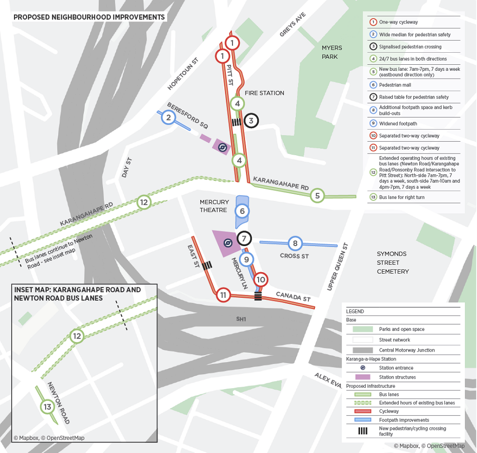
There are four key parts to the proposal AT are consulting on:
- A pedestrian mall on Mercury Lane
- Walking and cycling improvements
- Changes to parking and loading zones as well as to traffic circulation
- Improved infrastructure for buses
Let’s take a more detailed look at what’s proposed:
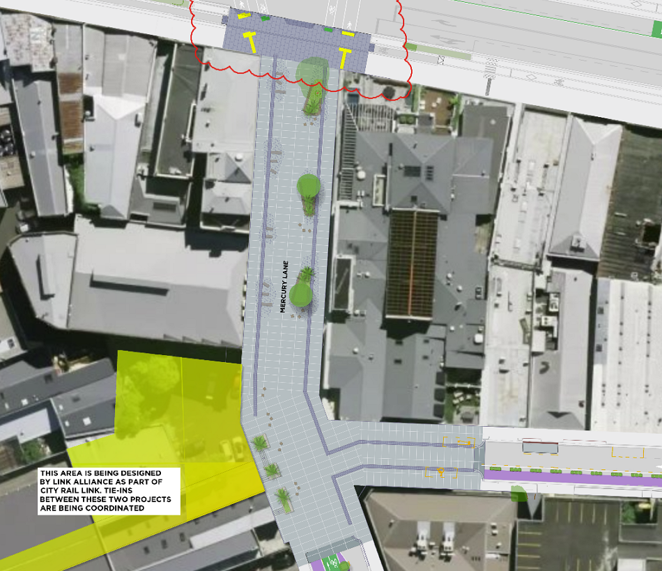
Mercury Lane Pedestrian Mall
AT is proposing to make the top part of Mercury Lane a pedestrian mall. This will be from Karangahape Rd down to Cross St, giving much more space for pedestrians, people on bikes and for trees.

And, seen from above:
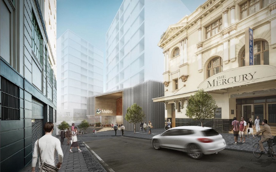
This is a vast improvement from previous plans, which were shown with images like the one below, with cars speeding through the area and narrow footpaths so parking for a handful of cars could be retained.
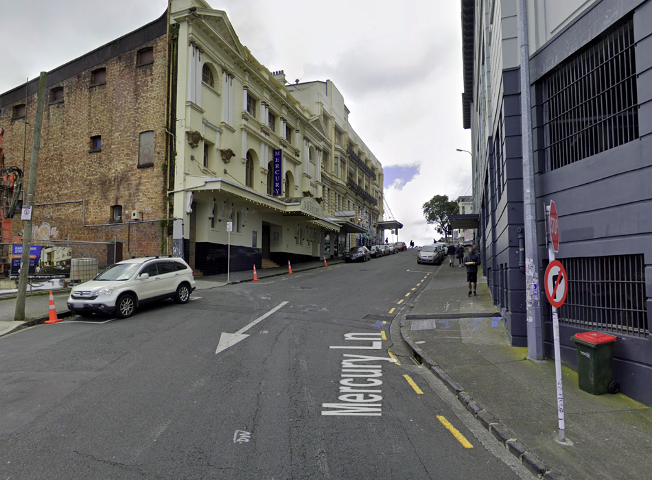
 As a quick reminder, this is what the space looked like before work kicked off on the CRL.
South of Karangahape Rd
On the Southern side of Karangahape Rd, AT is also proposing to add a bunch of new bike connections on surrounding streets. This includes:
- A dedicated bidirectional cycleway on the rest of Mercury Lane not that is part of the pedestrian mall – and also widening the footpaths here.
- Shifting the existing cycleway on Canada St from a current shared path into its own dedicated space, thus separating bikes from pedestrians.
- Retaining the tactical bidirectional cycleway on East St, which was initially a temporary measure for safety and access during CRL construction.
To support this, AT is also retaining and formalising the current one-way section of road linking Canada St westbound to East St, and creating a teardrop turnback so cars don’t get stuck:
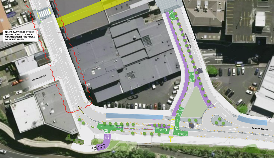
And this is at the Upper Queen St end of Canada St – a slightly more intuitive and manageable link across to Grafton Gully cycleway, as well.

Cross St also gets an upgrade, with wider footpaths and general on-street parking removed. There may still be some loading zones or other options such as spaces for car share or short stay pick up/drop off.

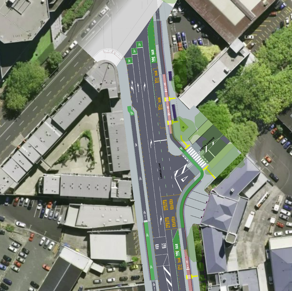
Pitt St changes
Pitt St is also getting some love, with changes including:
- A signalised pedestrian and cycle mid-block crossing, with bus priority signals
- Northbound and southbound bus lanes
- New bus stops, ensuring users of the new northwest bus services have a convenient connection to train services as well as local amenities
- Dedicated one-way cycle lanes, to replace the current/ interim Pitt Street shared path situation on the footpath
- At least one lane of general traffic in each direction
- New trees and landscaping
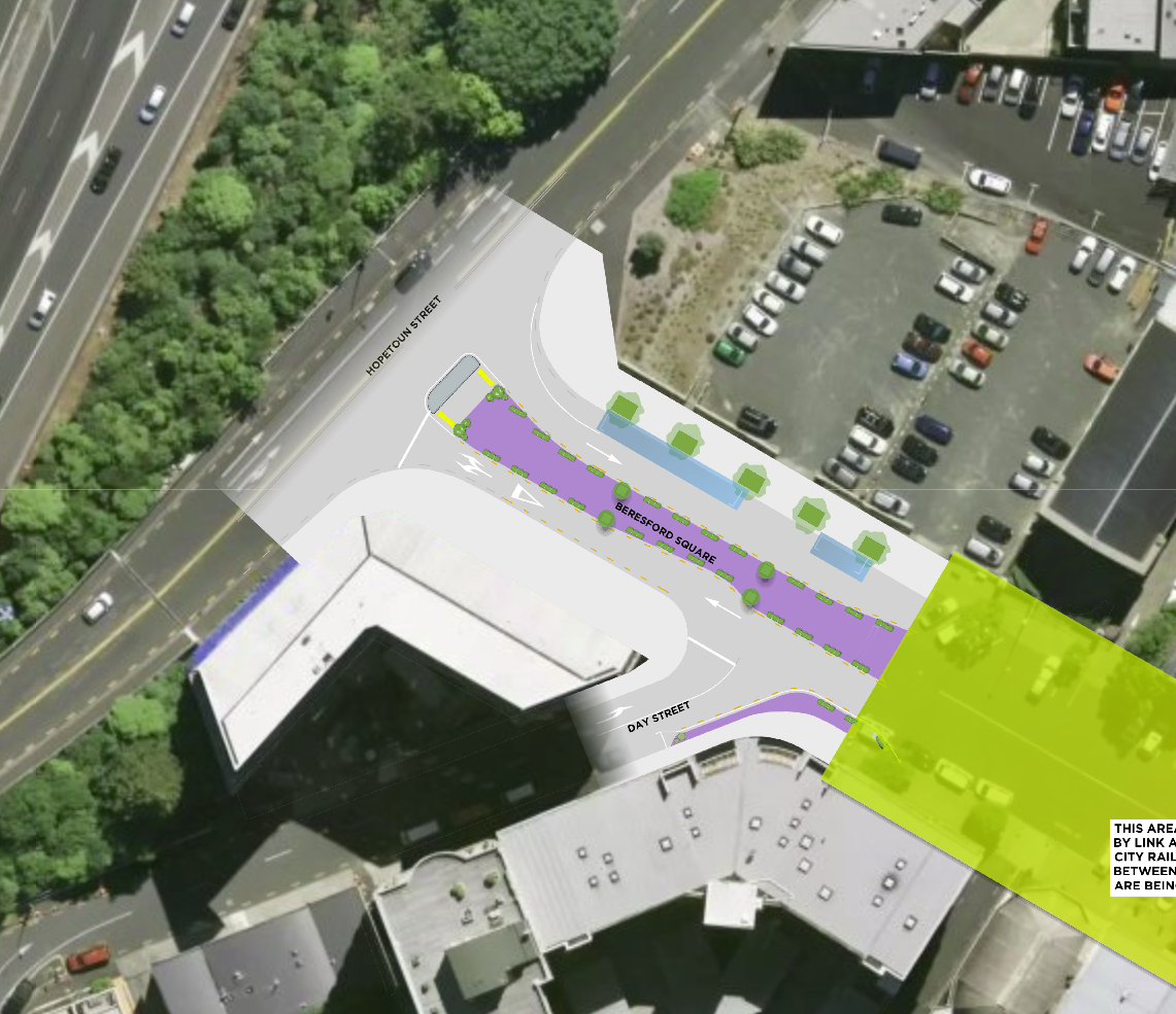
- Removal of on-street parking and loading zones, and relocation of mobility parking to Beresford Square, recognising the need to prioritise movement and place on this key arterial
Here’s the first part. The raised pedestrian crossing to and from the Beresford Square entrance will also help towards bus priority, as buses will have priority signals so they can go before the general traffic lane.


And the northern end, which extends as far as Vincent St. The main concern here is at the northern end where the cycleway just disappears back onto the footpath just before the Greys Ave/ Hopetoun St intersection. Also, it’s a shame we can’t get some more trees in here – those are some pretty stark and unshaded footpaths.
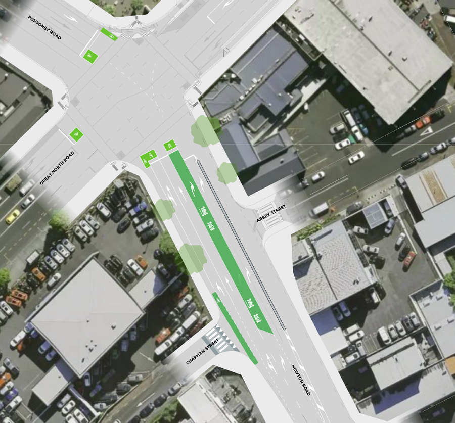
Other Changes
There are a number of other changes proposed as well, which are intended in part to support the Northwest Bus Improvements that will see a Western Express introduced. Some of the changes include:
- A bus turning lane on Newton Rd
- Creating a new section of bus lane on Karangahape Rd and changing bus lane hours, with the lanes on the northern side extending to be 7am-7pm, seven days a week.
AT says these changes will make buses “1 to 2 minutes quicker and consistently more reliable“.
Note also some changes on Beresford Square west of the station, to narrow the traffic lanes to encourage slower speeds in this short stretch. Although I don’t understand why they’ve chosen to do this via a widened median, and not widened footpaths with more trees.
Overall, these changes look great and should be supported. They will build on and enhance the outcomes of the CRL and the recent Karangahape Rd streetscape upgrade.

 Processing...
I didn’t realise the WX will be using Newton Rd to access the motorway – the on-ramp there is already rather unsafe for pedestrians and cyclists to cross, so are we not getting anything to help manage that?
I believe that they are using the Newton Road off-ramp, but the Hobson Street on-ramp.
Interesting. Is there a full route map floating around? The only one I’ve seen is for the consultation, and it doesn’t focus on the city-end at all
That would cut off the transfer point on K’rd for anyone going west, from places like the hospital or Newmarket. I certainly hope they don’t do it that way.
Changes look great, first time in a while I’ve been impressed, lets just hope it doesn’t get massively watered down or cancelled especially with the likes of Wayne Brown and our media lurking around.
Actually looks good, really hope they don’t back down and that bus priority through to Ponsonby, etc is properly done. It’s quicker to walk from town sometimes
Where did that come from?.With all the dicking around with Queen St, this looks absolutely revolutionary. Mind you ,it is transport planning 101,with a massive increase in traffic forecast,albeit non motorized,reallocation of space is necessary. The key will be holding firm in consultation,compromise upsets everyone, parking enforcement will necessary as well. If bus bottlenecks are still there after implementation, keep tweaking,until it works.
AT and CRL team have been developing this over the last year and a bit, and since I saw it in 2022 for Bike Auckland, it has actually increased in scope and quality – congrats. Now of course the question is whether it a) gets approved, b) funded and c) built. Lots of things could still go wrong, sadly.
But still, very promising! And with the CRL creeping closer to reality, the likelihood of this being done is hopefully a bit higher than a lot of other projects we need as urgently, but have no real institutional / project pushing behind them to keep up momentum…
Would have been nice for the Pitt St Cycleway to go to Nelson Street at least to link it up. Following that improve cycling/walking all the way down to Vic Park on Union across the offramp.
Yes – that’s an important link. And there’s plenty of space to play with.
Yes – absolutely. At present it is a nasty disconnected mess on a bicycle between Nelson St and Karangahape Road.
Hobson Street also needs a two-way cycleway to be a twin of Nelson St and improve connectivity in the area. This is in the Auckland City Centre Masterplan and has been under development in one way or another for years. https://www.aucklandccmp.co.nz/opportunities/hobson-and-nelson-streets-more-liveable-green-twin-avenues/
Sigh. So good.
“a few rumours flying round that they were going to cancel it.”
Yeah, about that: the story seems to be that the outgoing AT CEO was going to throw the whole thing into the trash, at the instigation of Mayor Code Brown and Councillor Waiheke Sea Goblin – but the decision was reversed by the new CEO. I would love to hear more on those shenanigans.
It would save a lot of money if they knocked over the Mercury theatre now before some idiot decides we should spend a small fortune of public money on it just because it is old.
I think the Mercury Theatre is owned by a Church called Equipers. They have outgrown it and it is currently on the market.
http://www.theatrescenes.co.nz/mercury-theatre-and-the-auckland-venue-problem/#:~:text=The%20company%20folded%20in%20the,Equippers%20Church%20for%20their%20services.
Equippers still owns the building, but they are wanting to use it as a concert venue. They closed it partly due to the CRL works (impossible to get anything in or out of the building for events) and so they could refurbish the building while the CRL is still going on.
A little while ago, I went to k road and my cousin showed me where the city rail link station was going (on Mercury lane). I was perplexed and started laughing at the thought of people flooding out of the station down narrow footpaths on that shoddy looking street. So I’m so glad to see these improvements being made!
Could you imagine if carparks were deleted from Cross St, Mercury Lane, Beresford Square and any other minor lane that surrounds Karang A Hape ridge? That these became apartments and the carparks were kept out of the city as they should be, a short train ride from anywhere would have you up town mid town or downtown, so why the need to park your silly antisocial stress inducing private vehicle? Can AT AC etc. just get this correct for a climate change emergency and push delete on the hideous carpark buildings that are occupying residential airspace? For a town planner it is so simple, just convince the people that we are killing ourselves with fossil fuel, and that Papatuanuku has run out of patience. We are only human but if we care about our future or our grandchildren’s or even our own lungs, it is the only logical health and science based solution!
If the pandemic taught me anything, it’s that the majority of people DO NOT care about their future or their grandchildren’s existence, if it causes them any inconvenience or loss of perceived status in the short term. And the more you lecture them about it, the more selfish and violent they get on the subject.
Why are the one way cycle ways on Pitt St (1) and Newton Rd not separated?
“Paint is not protection”
Pitt Street IS proposed to be protected (up to Vincent)?
The short bit on Newton St is not, but to be fair, it’s an unchanged existing bike lane – and not actually currently a sensible route for any but the most confident riders anyway. You’d need to do much more extensive works on Newton Road to fix that, and no project can fix everything. The bus lane on that approach is going to be a good change, even if you will still need to take another route from the NorthWestern to get to Ponsonby Road, rather than Newton Road for the forseeable time…
The corner of Canada st and Upper Queen st is quite dangerous for cyclists now (blind corner on a steep road with no defined cycle lanes). I’m so happy they’re fixing that situation! I have seen cyclists nearly collide there many times.
Excited for the cycle lane on Pitt st too, though it kind of negates the purpose of the light path as now they’ll connect the same areas.
The light path will still be a more direct connection to Nelson St. than via Pitt St. with all the intersections and waiting for lights.
What we REALLY need is a level pedestrian/cycling overbridge reconnecting the line of old France Street, from the former Kings’ Arms to Mercury Lane. I wonder whether that’s technically possible short of entirely burying Spaghetti Junction
I don’t really think that’s a high priority compared to many other gaps we have, even in the City Centre.
But yes, I am aware that some options for bridges in that rough alignment have been considered in the past, for example for Light Rail (with a cycleway alongside, presumably). I think there was even one concept option along that alignment when they first looked at connecting Ian McKinnon to what became Grafton Gully Cycleway… I probably have the concepts somewhere in my emails, but without an AI able to assess attachments and images I’ll never find em… 😉
And yes, such a bridge would be totally feasible. Lots of gaps between the motorway lanes to put columns supports in. But as I said I think we have more urgent places to spend 20mil…. the improvement along the Canada St / Upper Queen St corner will already make the loop east a lot more palatable, I think.
That advance cycling box on the right turn from Newton Road cracks me up.
Just imaging hoofing up that hill and crossing 2 busy lanes to get in the way of a bus while drivers cut by left *and* right. Delightful.
All looks like a great improvement.
“a slightly more intuitive and manageable link across to Grafton Gully cycleway, as well.” – is that an underpass from the western side proposed?
No. I think Matt was just referring to the fact that the extra space for active modes on that corner will make it a bit easier and safer to get to the crossing over Upper Queen Street than the current arrangement where you have to concentrate on not hitting other people on bikes, not hitting other people on foot, while not falling over riding up a steep hill, all in a constrained space. At least the conflicts will now be a bit more sequential than all at the same time, and maybe they can improve the gradients a bit.
This is a great proposal that is fully consistent with the Auckland City Centre Masterplan (CCMP). https://www.aucklandccmp.co.nz/explore-the-city-centre-masterplan-area/karangahape/
When the station opens, it will transform connectivity and footfall in the area. It would be most illogical to put the road back to its 2016 state. Well done to AT for getting this together. But it SHOULD have been planned as part of CRL. It is imprudent to spend billions on new urban rail without planning for commensurate public realm transformation.
By way of comparison, look at the Crossrail Urban Integration programme in London.
“Crossrail has explicitly recognised that the future passenger experience of the new railway will go beyond a reliable and punctual train journey and high quality station design. Crossrail’s passengers will also judge the success of the railway by their experience of using the spaces outside the stations as they arrive and leave. In order to set high standards for the immediate surroundings of the stations in terms of the design and functionality of the transport interchange and the urban realm, the areas need to be planned and implemented by a number of public bodies and funding is required from a number of sources.”
https://learninglegacy.crossrail.co.uk/documents/places-and-spaces-crossrails-urban-integration-project/
Down Mercury Lane and turn left into canada street (e.g. heading for the northwestern)
Currently this is a fast bottom of the hill corner where you can carry your speed and get halfway up the canada st hill to upper queen street before you need to start pedalling
In the new plans it’s a stop and give way T intersection at the bottom of the hill, and now pedal all the way up to upper queen street.
It’s the same thing they did with ian mckinnon into the city, previous a fast down hill and carry your speed up the other side, now it’s a turn left off the roadway and stop at a completely blind T intersection with the northwestern path.
But the rest of the changes look fantastic.
Looking pretty good!
I am hoping the Citylink bus will have a new stop on Pitt St? Currently the drivers are having issues with people who are desperate to get off at the corner and sometimes just jump out anyway, sitting in the bus waiting through two sets of light changes for a couple of cars to cross K to go down Mercury is absolutely painful.
I’m impressed. Overall plan looks great. Kia kaha AT and AC ; get it done.
I agree with you. How long did you spend researching this?
Up to 40,000 individuals are projected to use the Karanga-a-Hape station daily, with tens of thousands more arriving or passing through the area on buses.
nice job guys
Exclusive Song: Ragham To nmisham With Text And Direct Links In UpMusic
Consistency is key: Strike a balance between staying top-of-mind and avoiding email fatigue by sending valuable content regularly without overwhelming your audience.
The changes are impressive; it’s been a while since I’ve felt this optimistic. Let’s hope they remain strong and aren’t diluted or canceled, particularly with Wayne Brown and the media watching closely
The improvements are really good. I haven’t felt this hopeful in a long time. Let’s cross our fingers that they stick around and don’t get watered down or scrapped, especially since Wayne Brown and the media are keeping a close eye on things
Great success…
Gooood, tank you 🙂