It’s been a while since we took a look at the City Rail Link and they’ve been putting out some pretty interesting images, videos and information on their social media channels recently so here are some of the best ones.
Yesterday CRL released this video of a drone flying through the Te Waihorotiu station. One thing that is notable is that the civil works on the project will be completed by Easter and the majority of the work has shifted to fitting out the stations and tunnels. That work is expected to take till Easter 2024 when the project moves into a “testing and commissioning” phase.
They also recently released this image looking at the station from the platform that in a few years, should be bustling with people.

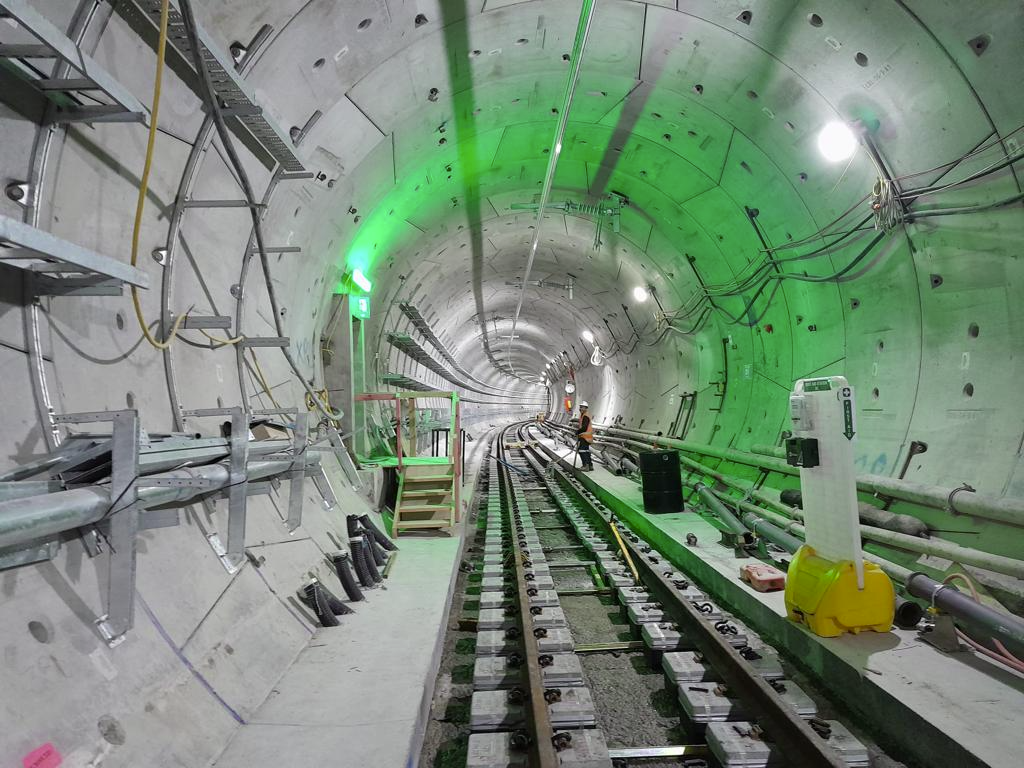
They say the tracks between Britomart and Te Waihorotiu are nearly complete. You can also see some of the traction systems starting to go in too.

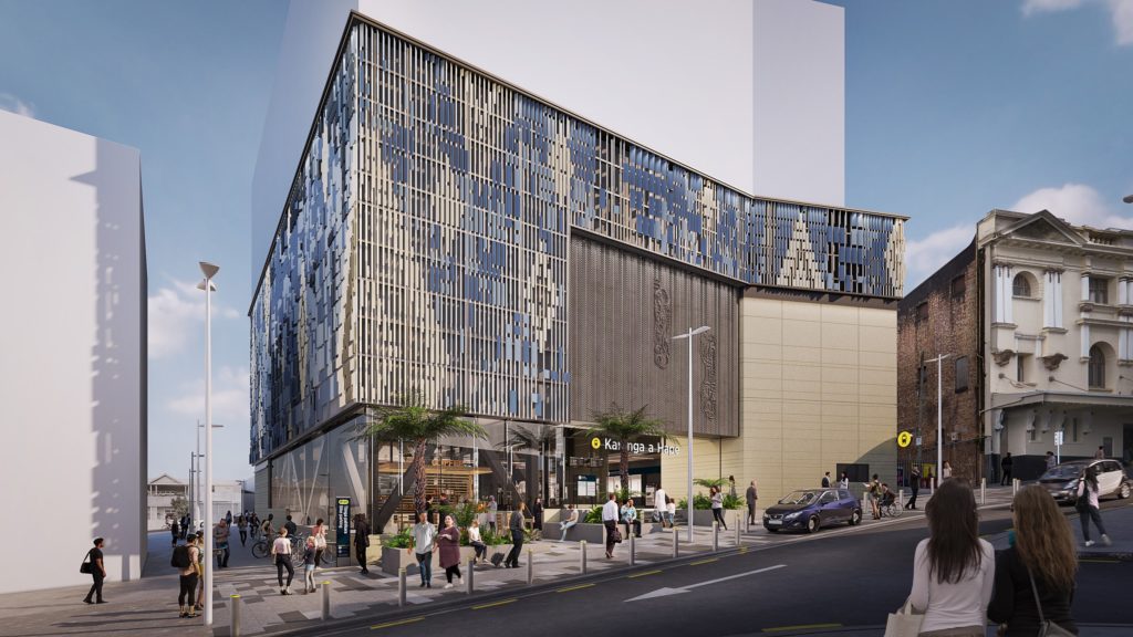
And then there’s this from Karanga-a-Hape where the platform is also being installed.

That’s a big improvement from a month or so ago when there was flooding inside the tunnels. Thankfully there was no significant damage from the flooding at any of the CRL sites.

There’s been a little bit of noise about this recently but I understand that Auckland Transport will soon be consulting on some proposed street changes around the Karanga-a-Hape station. Ideally this would mean changes such as closing off Mercury Lane to vehicles – there doesn’t seem need for it as nothing that can’t be accessed other ways, and improving Pitt St.
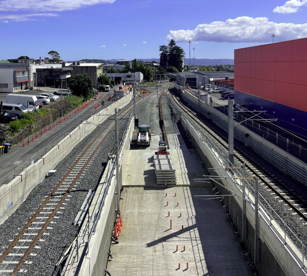
Further south at Maungawhau, tracks and other systems are starting to be installed in the bored tunnels
The last of the concrete has also been poured for the track base where the line into the tunnel splits off from the Western Line. In the image below you can also see the start new platform that will serve trains heading into the tunnel.

The westbound track through the Maungawhau site along with the traction equipment appears to be almost complete but CRL say it won’t be in use for double-track operation till the mid-year. With the recent appearance of sleepers and tracks to the site, I imagine it shouldn’t be too long till we see them start to head into the tunnel.
The footage here is from December so a bit old now but its good for putting into perspective the size of the site and where things are at.
Yesterday CRL gave some numbers on just what is involved in the fit out, and they’re substantial.
The fit-out, including architectural elements, includes installing the tracks, sleepers, electronics, safety systems and other essential componentry. The logistics involved are boggling:
- more than 16kms of rail track
- 816kms of signal cables
- 247kms low voltage cables
- 86km traction cables
- 74kms cable containment
- over 5,100m2 metal cladding and
- Around 4,000m2 of glazing.
CRL delivery partner Link Alliance has established a Systems Integration Facility (SIF) at the old Chief Post Office in Britomart, reopened to public acclaim, to integrate the CRL software and hardware into existing KiwiRail and Auckland Transport systems.
This programme of work is difficult and critical to the success of the CRL when it opens. It’s taken seven months to acquire all the software and hardware (COVID-19 disrupted the supply chain), with two kilometres of cable just to connect the SIF and before it is even integrated into the system.
Finally, the one major unknown with the CRL that we’re still waiting to hear about is what it will now cost and when it will be finished. In a select committee hearing a few weeks ago, CRL said this was likely to be within 10-12 weeks.

 Processing...
Hard to believe this is Auckland. It’s going to be so exciting when it opens, well worth the wait.
Proof we can do big infrastructure. Its a shame that we’re following this up with an over-engineered light-rail line (when an adequately engineered one would do).
It would be great to see more big projects like this outside of Auckland too.
“It would be great to see more big projects like this outside of Auckland too.”
So would the rest of NZ!
The Coromandel, for instance, would just like a road in and out that doesn’t fall down every time it rains.
Yes, but Thames-Coromandel (the whole District) has, what? 50,000 people (slightly over 30k back in 2019, so doubt it is that high now even being generous).
That population includes my very loved family, and they do get a lot of visitors to the area. But so does Auckland, and Auckland has nearly 50 times the population. Plus I think the amount of transport spending in the Coromandel will be pretty big in the coming years, so it’s not like it will be ignored.
Should we be encouraging people to move to the Coromandel by spending billions on roads? It will always be an economically marginal backwater prone to extreme weather events. Just because the boomer generation want to move there (and the West coast beaches) and have been doing so for the last 30 years or so, doesn’t mean they should be indulged in their wishes. Cue loud tantrums and threats of litigation etc etc.
Logically speaking, the Coromandel should be cut off from the rest of the country, and remain that way. It is so much nicer in winter when all the Aucklanders aren’t flocking there and ruining everything. It’s quite a nice laidback place when there are only a few wizened old gold diggers and hippies.
Its not an either/or. Of course the Coromandel needs appropriate roads, with as much resilience as we can afford realistically. It’s when we keep rebuilding roads in the same way, every time, in the same affected risk locations that we go wrong – or even worse, if we let some grifter convince us that we need to upgrade by building lots of new four-lane divided highways as a response to Gabrielle. We should start with building increasing numbers of 2+1 roads (and a lot more wire rope median barriers) but should run screaming from anyone who proposes that we need more “motorway” or “expressway” funding.
But part of the charm – a big part – of the Coromandel is that it does NOT have any 2+1 straight strips of asphalt, but instead is composed of miles of really wiggley, narrow, winding, buts of bush-clad road. As soon as you start putting in any boring straight roads of large width, then all that will happen is that you get more traffic, and faster cars, with boy (and girl) racers down from Auckland or across from Hamilton.
No, I would advocate for no widening at all – by all means fix them if you can, but retain the magic and impossibility of the existing narrow road network that works so well to keep the tourists away.
Yes I agree, it’s part of the charm of the coromandel.
They could fund it like Auckland has with CRL, 50-50 rates money and central govt money. I genuinely believe that a lot of councils could get a lot of good infra stuff done if they were voted to / the locals wanted to. “go halves with us on x” is a lot better sounding than “buy us x”.
Unfortunately we only hold rail to those standards. Communities are used to having highway funding bequeathed upon them by the NZTA and seem largely incapable of helping themselves. Keep rates low at all costs, and when the chickens come home to roost blame not receiving enough of workers income taxes from central government.
” I genuinely believe that a lot of councils could get a lot of good infra stuff done if they were voted to / the locals wanted to. “go halves with us on x” is a lot better sounding than “buy us x”.”
Ummm… that is how transport funding works for pretty much everything in New Zealand? 53% of the average (road) transport project is funded by govt.
https://nzta.govt.nz/planning-and-investment/planning-and-investment-knowledge-base/202124-nltp/202124-nltp-funding-assistance-rates/about-funding-assistance-rates
The issue is that for some TYPES of transport like rail, those factors do not apply. I think there also used to be things like footpath maintenance (unlike ROADZ maintenance) receiving less funding, but that may have changed. Haven’t kept up with the FAR rates in recent years.
I should clarify I mean in terms of regionally important transport capex spending.
ie SH25. Could buy a heap of slip resilience with relatively little money.
I can’t think of projects on these regional highways that have any council money put in. Although I have mainly been looking at larger projects.
Nope, that simply does NOT work with a small population like Coromandel, who get a regular massive influx of Aucklanders across their borders. They simply don’t get enough money in from the AKL tourists – no GST, no rates, no Capital Gains – what might work better is a $500 entry fee per tourist.
Works OK (just) with Aucklanders, as there are so many of you.
State highways are funded by central government. Non state highways, i.e. local roads are funded jointly by central government and local government.
I’m unsure what Aucklanders or population influxes have to do with your road resilience? they aren’t making the roads slip, and they can miss the odd weekend when the weather is crap anyway. They neither need those roads to be more resilient, nor make the resilience any worse.
The city and her population aren’t some cash cow to buy people that choose in high infra cost areas quality of life / resilience.
Auckland needs rail to Mangere and airport business precinct via Onehunga. Auckland does not need tunneled light rail down the isthmus. Tunneled light rail only enlightens Labour partymongers locked in their tunnel vision.
When you look at all the construction, it’s very hard to imagine that underground light rail will ever proceed,I’m no engineer,but apart from the rails almost everything else would be the same. Are we that invested in our car culture,that a proposal to basically repeat what is being done here,has got traction?. lt beggars belief ,that it(ULR) is still being pursued,is this politics ahead of pragmatism?.
“Are we that invested in our car culture?”
Lots of people are, lots of people aren’t.
The key is to have effective leadership that helps us to navigate the change required to reallocate car space (for street level LR, cycle lanes, bus priority etc).
Why can’t we get economies of scale and use our current 3-car CAF trainsets instead of tunneled light rail? There is no need (in foreseeable future) for 6, let alone 9 -car trains down the isthmus to Mangere / airport. Heavy rail 3-cars would give similar, if not greater, capacity than any light rail proposal. Building stations to only 3-car specs also save money. Fleet commonality removes overhead associated with introducing new train variants eg. new workshops/maintenance yards + labour. AT can always ramp up capacity by adding frequency – a win-win for commuters and operations. Finally, flexible integration into the wider network is easier with a common fleet, permitting line route changes as required.
Regarding closing off Mercruy Lane, I think the decision to prevent right hand turns from K Rd into Upper Queen Street will make doing this difficult for AT – they have effectively directed all south-bound traffic from Pitt Street to use Mercury Lane and Canada Street.
However, it could work if south-bound Pitt Street traffic was directed down Hopetoun Street and Newton Road instead, although that may be too much for AT to agree to…
I can’t understand why Mercury Lane is still open given the obvious extended crack in the Mercury theatre facade.
The entrance ramp from Victoria St looks like it will funnel rain into the station?
Drive right in baby. How long until the CRL gets ram raided?
I’m no expert but that might be what the bollards in the image are for.
Being Auckland, some idiot will still ram a car in there, bollards or no.
“The westbound track through the Maungawhau site along with the traction equipment appears to be almost complete but CRL say it won’t be in use for double-track operation till the mid-year.”
Their Facebook page said Easter a couple of weeks ago. Where is this updated information?
Great video. Thank you.
Are you going to have the railway Station names written in English and Maori so that non Maori speaking passengers can understand where they are actually going to.
Many thanks
Philip
Looking forward to racist clowns demanding translations for Orakei, Ōtahuhu, Papatoetoe, and so on
In fairness, the station names you mentioned are after well known suburbs. Te Wai Horotiu is unknown, Queen Street is well known.
Tourists (local and international) have good knowledge of Queen Street, not an unknown, out of sight, underground drain.
T- Dub station, K’rd station…
You don’t even need to respond to this blatant racism. I can’t imagine this same person travels to Paris and demands they change their station names because they won’t be able to understand where they are. Just let these dinosaurs fade away. Seems to be more and more trolls on this site every day..
It’s not “racism” to blatantly point out the station is named after an unknown location.
Joe just wants his comfy little circle jerk back.
I’m guessing if we named it King Charles Station (without any geographical reference), he would figure out where it is pretty easily.
But Philip’s post wasn’t about navigating a rail network, was it.
I’m sure Greater Auckland is not going to be naming the stations. But a quick google will show you https://www.cityraillink.co.nz/meet-your-stations
Te Waihorotiu Station (Aotea) might blow your non-Maori mind
Personally, I would have kept Aotea. The new name is just going to be shortened by users anyway. Probably “Te Wai”.
Or they’ll just use Aotea.
Poor dears. How will they ever find their way to Ngaruawahia, Eketahuna, Wainuiomata etc.
How will they ever find their way to Ngaruawahia, Eketahuna, Wainuiomata
Are these the names for the new stations on the Light Rail system?
Lol
Sorry, doesn’t look likely, I think you’re just going to have to blunder you’re way around the rail network hoping to find what you’re looking for.
I’ll give you a clue with Karanga-a-Hape though…
Let’s be democratic for once, and and have a Citizens vote on the
naming problem.
I have no doubt what the answer would be. Oh, sorry i’m forgetting
this is not Switzerland.
I wasn’t aware that Switzerland had a citizens vote about whether it could use one of its 4 national languages.
Oh, that’s right. It doesn’t.
If we let people vote on it the stations would all be called StationyMcStationFace.
I noticed you don’t provide a translation of your name from Ancient Greek into English Philip. Surely you should start by telling everyone the translation of your name is Horse Lover for those of us who don’t speak Greek.
Applause
You don’t need to understand english or maori to read a map or use google maps so the station name is not particularly relevant.
Regarding Mt Eden and Britomart the NZ Geographic Board report and recommendations on the proposed names states “ In at least the short term, retaining existing names would be conductive to location identification” . So dual names for both stations seems likely for a while at least.
At least someone has the manners to answer the question.
Thanks David T
The anti-white racism on this thread is disgusting. Having Maori only names for the stations is a breach of Article 3 of the Treaty. One can only hope that our authorities show some rare spine and use both English and Maori names for these stations
Silence, Real Matiu
Are you demanding a Maori translation for Fruitvale Rd?
@KLK if there is a Maori translation for Fruitvale Road then yes I think it should be there
Well that is where you are mistaken. Many Māori place names don’t have a translation as they are someone’s name or are named after an event that happened in that place. If you are interested in how the locations got their Māori names do some Googling and you will find the answers. There is some fascinating history behind many of the names.
On the westbound track they wrote that they excavated to a depth of 9 meters and used 300 concrete trucks to pour 16 000 cubic meters of concrete.
This is a reminder why tunneled light rail would be very costly.
Huge amounts of concrete would be required at $300 per cubic meter and would take a large chunk of any of our volcanic cones.
You mean like at Puhinui, Orakei, Otahuhu and Pukekohe?
I guess you can’t drive to Orewa without Google directions. And I guess you have never been able to take the train in Paris.
Response for Philip, above.
How can anyone ever be expected recognise unique distinct sets of latin characters!!! :((((
My ability to have any change in my life or learn anything disappeared 40 years ago, the world should stay completely stagnant in the ways I desire.
What is this? A competition of who can be the biggest dickhead?
There’s no competition, no one can compete with Phillip
T-Dub station looks great.
Gonna cruise past T-Dub in my V-Dub
Considering how nicely Light Path connects to Mercury Lane, it would be too obvious to make this a nice pedestrian / bike friendly quarter, with so much foot traffic already in the surrounding Karangahape Road area. That would make the three inner city stations all comparable to international ideals, multimodal without private motor vehicles to pose any risk to any human. And yes very exciting to think about a non cul-de-sac Britomart and a functioning City with a Rail Loop!
Mercury Lane needs to be closed to through traffic. When you have tens of thousands of people walking to/from a station entrance, it’s not sensible to allow cars and trucks to go zooming past. This is pretty basic transport planning.
The current render has a big one-way arrow and two cars. What a wasted opportunity. This should be a space for people. Must do better.
https://www.cityraillink.co.nz/stations-karanga-a-hape
Fully agree. Also will make Pitt St a much more efficient intersection for all those buses, will simplify the signal sequence, and be so much safer for all users.
A dead easy decision for a transport agency with the clear values, correct priorities and evaluation processes.
Sigh
Matt L – you’re quite right to query the final cost. Whilst a fan of the CRL concept every project needs to work from a cost/benefit perspective. The finance aspect of the CRL has been an absolute disgrace to the point that one suspects the original costings were manipulated to get the project underway.
The next thing to query is the carbon impact of the project. How much carbon has it taken to produce all the materials and construct the project? How does that compare against the expected carbon savings?
The final question is where are the media? When Transmission Gully went 25% over budget we had a week of articles condemning private/public partnerships telling us how evil they were. The CRL is likely to come in at least twice the highest estimate. Are the media preparing condemnation or will they give their socialist mates a free pass on this one?
I prefer the fake Matthew.
Misleading final point there Matthew. Condemning the PPP model was not condemning the BCR. There are scant articles on the cost side of things on TG. Let alone the other expressway sections some of which are truly abysmal. O2NL, 1.5 billion, up from an original projectection of just over 100 million, 0.3 BCR. Not an article to be found.
A large part of the CRL BCR depends on how much housing / business is developed around the stations. With the NPS-UD now forcing huge unitary plan changes, it will be quite a bit more than was originally thought.
From the PM’s office today, in naming the latest policies to face the chop:
“Light rail: Hipkins said it would continue in some form, but it would be delivered in stages. He said more details on how the Auckland Light Rail programme was being rescoped would be announced over the next few months.”
Getting the RoNS treatment by breaking it into chunks. And surely, that also means surface LRT.