Yesterday Kiwirail announced a new consultation for two of the three stations they’re planning to build between Papakura and Pukekohe. They previously consulted on this at the beginning of last year with just some very high-level information about station footprints and intended facilities. We also saw some more details in November last year. Those designs have now been refined and with a bit more detail. The stations are expected to start construction next year and be completed by late 2025.
Sadly they do nothing to allay my concerns that these stations are focused on entrenching auto-dependency in these greenfield growth areas – despite all the claims to the contrary.
The Government, through the New Zealand Upgrade Programme, has provided funding for three new train stations between Papakura and Pukekohe. The stations, which are expected to be completed in 2025, will be located at Drury Central, Drury West and Paerata. We are currently seeking feedback on Drury Central and Paerata stations.
Planning approvals were granted for Paerata and Drury Central stations in early 2022 and planning approvals are currently being sought for Drury West. To help connect with local residential areas, each of the stations will include a bus interchange, park and ride facilities as well as walking and cycle paths. Up to 350 car parks at each of Drury Central and Paerata stations will be provided and up to 200 car parks at Drury West. The expectation is that people driving to the stations will live throughout a wide area including North Waikato as well as towns and the rural areas to the west and east.
New road accessways will also be developed which will connect the stations with adjacent arterial roads. Waka Kotahi has projects on these arterial roads which will improve access to existing and future residential areas. The three stations are being future proofed to provide for a number of elements including space for additional rail tracks and longer platforms for nine car trains.
We would like to hear your feedback on the road accessway and car park layout for these two stations. We are not seeking feedback on the station buildings or platforms as these elements are built to a design standard and there is no scope for change. We want to know of any problems you see on the designs and any suggestions to improve. You can let us know what problems or suggestions you have on the designs by writing down your point with an arrow indicating what location on the map you are referring to. If you have any other comments, please use the any other comments area on the feedback form.
We are working closely with our Mana Whenua partners on the design of the stations including reflecting the history of the local area in the design of the station buildings. We will continue to work with Mana Whenua partners as we finalise all aspects of the project.
Drury Railway Station (Drury Central)
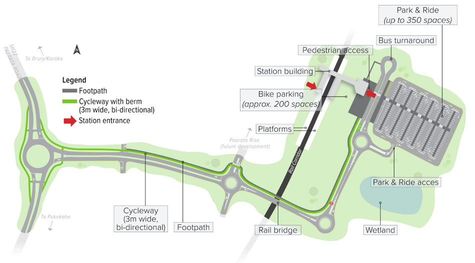
The station will sit alongside Gt South Rd just south of Wahoehoe Rd.
My big concern with this station is that they seem to have designed to make it as hard as possible to access from the new housing planned for the area unless those residents drive. The park & ride to the east of the station takes up a lot of valuable land, pushing any housing at least a few hundred metres away from the station. A similar impact will be created by the wetland to the south of the station.
While I’m typically not a huge fan of P&R facilities, they do serve a purpose in on the urban fringe to serve nearby rural areas. However, here there are two changes that are needed to help ensure that the priority for access by locals is by bus or active modes:
- The location should be moved to the northern side of Waihoehoe Rd to allow more housing closer to the station. This would still be similar distance to P&R facilities at Glen Eden and Sunnyvale or the far end of the Albany P&R and that certainly doesn’t stop them being used.
- Charging for its use should be a condition for its construction and so should be committed to upfront.
I also wonder if there’s a way to get that bus interchange across to Gt South Rd. It seems odd to have two different sets of bus facilities with the one east of the station likely only useful for serving ‘local rambler’ type routes. Combining the bus interchange facility on Gt South Rd would free up additional land.

One thing notably missing from the design is any footpath on the missing from the design is a footpath on the P&R side of the access road. That is something that was shown in the designs last year, which also had cycleways on either side of the road corridor.
There is some good thing about the plans though, most notably that it appears it’s designed with about 300 bike parks. Though while they stress this design is only indicative and subject to change, it’s a shame they’re not covered. – certainly something to provide some feedback on.

I still find it disappointing just how much this station has moved away from the original vision from the 2019 Drury-Opaheke Structure Plan showing a station surrounded by a plaza and town centre.
All centres should aim to provide for a mix of uses. Figure 3 illustrates a larger conceptual mixed-use centre with apartments, terrace houses, commercial buildings, shops, parks and public transport. Section 3.13 specifies the outcomes expected for these centres

This is the more recent masterplan design we’ve seen but is clearly different from what we’re seeing above. Also it shifted the town centre away from the station and some parking focused big box retail taking prominence.
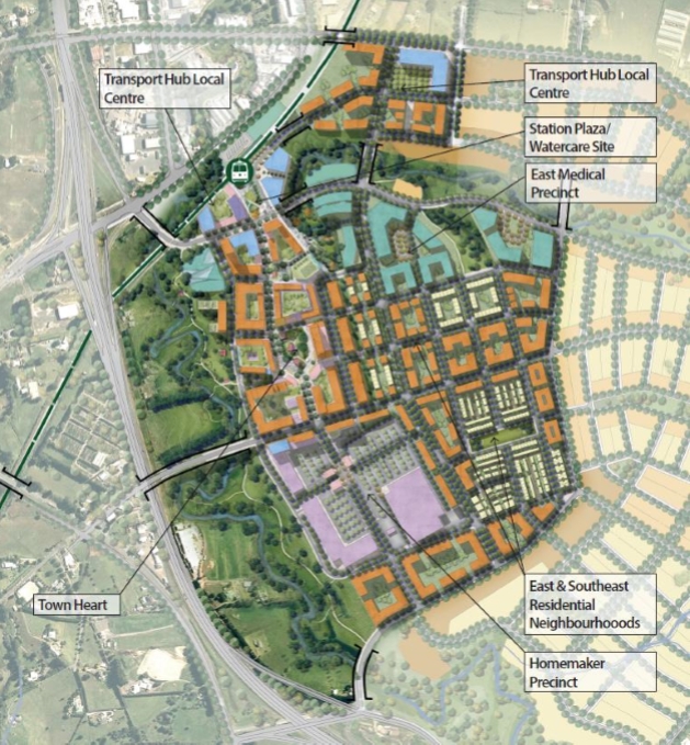
A large development is planned for the area south of the Drury Central station.
Paerātā
The Paerātā station plan is also fairly similar to what we saw last year, with the exception of a few extra roundabouts. Here the majority of the housing development is occurring to the Northwest of the station meaning active mode users will have a more direct access to the station than those accessing the P&R which is the way it should be. Though the station could do with some more bike parking on that side.
Longer term it is expected this new road will connect to Sim Rd and given that, I wonder if the road should be slightly closer to the station with bus stops directly over the station and access down to the platform straight from the overbridge – similar to how Park Rd interacts with Grafton Station. That would allow buses to eventually be through-routed instead of looping in and out of the station.
As a reminder, this is the masterplan for the Paerata Rise development and the road above that crosses the rail corridor is the southernmost black line.

Like with Drury, the render suggest more needs to be done to cover the bike racks.
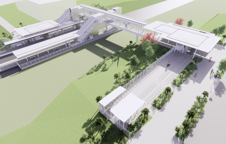
It appears that the terrain will allow for direct access to the station overbridge which is nice and makes me wonder if for both of these stations I also wonder if stations, we could make use of accessibility compliant ramps instead of relying on lifts which not only cost more to operate but have a regular tendency to break down leaving some of the most vulnerable customers stranded. There certainly seems to be enough space at these stations for ramps.
Kiwirail are still working on their plans for the Drury West station which needs planning approval and which one developer is fighting in court as he wants the station moved to primarily benefit his development.
The consultation links can be found here. There’s also some in person and online presentations coming up.
Sunday 27 November 2022 10am-1pm
Rise and Shine Café
(16 Jonah Lomu dr, Paerata)Sunday 10 December 2022 10am-1pm
Drury Hall, 10 Tui St, DruryThursday 1 December 7.30pm-8.30pm
Online presentation with Q&A (The link to this presentation will be live soon.)
Consultation closes 17 December.

 Processing...
ATs preference was for a station in the middle of an empty field. The opposed the Drury plan changes and even appealed.
These look completely over engineered. Its like, its all about a legacy building for the person designing it and then try to retrofit in access, etc.
I talked to the engineer when they were putting in the lifts and stairs at pukekohe station about the option of bike gutters on the stairs, I got blank looks and was told to use the lift. I am all for less reliance on things that break down. Which they have done.
Where’s the bus priority? Especially when buses have to compete with P&R traffic?
Let’s assume that the engineers, developers and planners are acting in good faith to produce workable access to these stations. The aim is to maximise passenger numbers not to be social engineers. I expect it will work out in the end. At the time the Manukau station was built I was critical of its location but in hindsight it worked out okay. At least nobody will be able to claim I don’t use the train because there is no park and ride however if the park and rides are full that will be a sign of success just as it is with the Northern busway. If you want to use the train there will be plenty of options to get to the station.
Why assume something for which there is little evidence? See below.
Do you think they go around trying to stuff up there work. They won’t be in their job long if they do that. I think they are doing their best to fit everything in.
No. Very few people ‘try to stuff-up’ yet much is stuffed up. So clearly stuff-ups are just that, suboptimal outcomes from people trying to do well.
I am suggesting there is a glaring gap between the strategy of delivering future urban TOD focussed stations, and biz as usual standard pattern unimaginative design as shown above.
That’s all, no malice imagined, only inadequacy.
“The aim is to maximise passenger numbers not to be social engineers”
Uhm…. so much wrong with this statement, including the claim that a designer being told to prioritise a transport mode is social engineering. Even if it is, we’ve been doing it for decades, only in favour of cars. Now our policies (passed by our politcians we elected, by the way) say different, and they still do engineering largely for cars. That indeed IS social engineering – basically saying “FU, this is what we prefer, no matter what your policies say”.
Also, maximising passenger numbers doesn’t work by maximising car parking. You don’t see huge park and rides in Japan or Europe taking prominence over bus and active mode access.
All modes are being catered for I see foot paths bike lanes bus stops and roads and car parks. And how do you know what the designer was told to prioritise. Seems to me to be pretty even handed.
Matt explained this in his blog. Why detour the buses into the site when all good PT planning says that this only makes sense for routes terminating. And I expounded more on it in my separate comment: Why no bus priority? Why, at 6pm, force every bus trying to get people home to share the lanes getting out of there with hundreds of cars trying to leave the Park & Ride?
“Even-handed” is not what the policies say we should do. The policies say we should prioritise PT, especially in new builds.
I expect its trying to find enough space for the buses so they are not queuing up to use the bus stops on the road and blocking traffic also bear in mind the aim is to future proof the design. So more space will be needed in time to accommodate more buses and passengers. Another problem will be bus stops are needed on both sides of the road and passenger would need to cross. This would require a zebra crossing or lights it would be a toss-up whether it would be any quicker than taking passengers into the station. Have a look what they have
done at Puhinui Station or Otahuhu. A much safer option than locating bus stops on busy streets.
The plan to get the most patronage is to build lots of homes and shops around the train station (in other words: a town centre) – not a park and ride.
In fact, park and rides are a really inefficient way to maximise passenger numbers. They’re only efficient if you’re not allowed to build homes or businesses around a train station.
Building lots of homes and businesses around a train/tram/bus station isn’t new, nor it is social engineering, it’s simply the patronage-maximising thing to do. That’s what they’ve done in the UK, in many other countries around the world for many many decades.
We used to do it too – just check out a centre like Kingsland or Onehunga.
All these parking lots are functionally land-banking. In 20 years put in some new towers.
Exhibit A – smales farm
Except these are/will be publicly owned car parks, so the Status Quo driving public will fight tooth and nail against losing them. As they do every time we try to get a cycleway or bus lane in by removing car parking.
Private developments can say “So what, you don’t get to decide” to the Nimbys. Politicians can’t. So developing publicly owned car parks in bad spots is not well-planned land banking, it is putting a major stumbling block in the way of future development. Any politician in the future trying to develop this will have to go the Takapuna way, and build a massive new multi-storey car park to “make up for it” and still end up in a shitfight.
Yes, but I don’t think this would be nearly as bad as Takapuna. A better example might be the downtown carpark.
And keep in mind, it only takes one council to sell / sign the contracts.
It is worth thinking about how to make it easier though. I wonder if i a better structure would be, if some dev agency like panuku or kainga ora own the land, and AT leases it off them for (say) 15 years. With options to end that early. This way the ongoing costs are obvious, council / AT is paying rent for the park. This makes charging for P&R more palatable. And the expectation is set from the start, this will one day be housing. And the public is gaining significant value uplift.
Also in time, putting in larger buildings will stack up more. So we could end up in a better end state. Huge towers by the station.
I think you’re dreaming, Jack. The last time to ever put in parking is at the beginning of a new development. It sets expectations and norms.
Chronic optimist
Both over designed and built (ie expensive af) and entirely sub-optimal. To mention butt two glaring issues:
1. Stations should be below road crossings so access can be direct from public realm, especially for bus transfer. Never, ever, take the station serving bus routes offline to the station, these must stay on their east-west through pattern for efficiency and effectiveness. Why spend extra millions on rail to expressly make the supporting bus service as slow and as expensive to run as possible. Where was AT’s bus team on this?
Parking is ok especially too start with, but should be designed as really good building sites simply being held as parking till that becomes viable. So low investment but also a road layout really as future streets, get trees in now etc, at the very least show this future plan and how it’s been worked back from.
These are not future urban stations, but permanent rural ones. Why? How is this in any way consistent with the strategic intent of the programme?
Other questions include: where do future tracks go?, ie show more of future condition.
The future tracks are allowed for – see for example the extra-wide overbridge at Paerata.
More sprawl BAU from this country, not much to get excited about really. That said, if we can’t even do TODs in metropolitan centres like Albany we sure as hell won’t be able to deliver them out in the wops wops..
Made Group just won their case that the Drury West station decision should be subject to a judicial review….. ( KR wanted it to be tested in the Environment court)
KR haven’t planned many new station locations, so I think that their processes will be found to be rather opaque and they will get sent back to do it again….
https://www.stuff.co.nz/national/130543750/kiwirail-loses-bid-to-stay-judicial-review-into-south-auckland-train-station
Outdated thinking from, dare I say, an outdated workforce.
A few older heads need to be rolled from Kiwirail I think and space made for people who have ideas rooted in the 21st – not 20th century.
The Pukekohe – Papakura section was already suffering from congestion with the DMU commuter trains, freight trains, Te Huia, Northern Explorer all fighting for clear space. Now we will have many extra commuter trains stopping at no less than three new stations with extra track capacity only “future proofed” but not provided on reopening day in 2025.
Kiss & Ride locations are not marked on either drawing. Like it or not, this is a major function at most train / busway stations and if not planned for well tends to have unintended consequences – with these designs, the “obvious” location it will happen is on the approaches to the roundabouts that are closest to the station entrance. There appears to some spaced provided in the car parks for his activity, but who will negotiate a car park to pick up and drop off where AT wants you to do it, when there is a more logical if not legal alternative closer to the station entrance, with an easier in and out route?
Yes I can imagine people getting dropped off on the roundabouts in the quite times when no cars are behind you. The Drury one could plant or fence a barrier it to prevent shortcutting through to the entrance. I can’t see easily how to fix this without creating more roading & roundabouts. There wouldn’t be so much motivation to do it at the Paerata one as the entrance is further away. I notice the Hibiscus Coast one has got the interim bus stops as drop off areas.
Every bike and car park should be required to be covered with solar panels. Pays for itself and amenity.
Does it pay for itself? Serious question – have you got any studies.
Considering PV is still one of the less reliable electricity generating ways and NZ already has a very high share of sustainable electricity generation, I don’t really feel it makes a lot of sense to burden transport projects with that. If it really paid for itself private developers would do it, and as for climate change… as noted above, there seem to be more effective ways?
Surely an array of that size would help pay for lighting some of the station. Other countries are covering bike parks with solar panels to shade the bikes, protect from rain and powers up something. Yes it would cost but we have to start changing how we view things like solar so why lead with something like this?
‘not’ lead
Because any cost always needs to be considered against it’s opportunity cost.
– Is this a good use of public money for reducing emissions? Or are there other, better uses for same funds? How does it stack up to, say, building an off-shore windfarm or drilling for more thermal? Or even just investing the same money into insulating more houses?
– Does it stack up over the long run? Solar panels need maintenance / cleaning / repairs. And afaik, they do still degrade over time too, so have a fixed lifespan. Are we including those costs?
– Does generation time of day / year stack up with demand peaks? [A leading question, I know, and NZ in some ways is better placed to deal with it, due to our hydro]
– Shade? Would trees work better?
I’m just saying that except for some press release / PR projects, nobody seems to be doing large-scale PV projects across car parks and cycleways and roads. So you’d need to make a case why we should. I think we should concentrate on the much bigger opportunities and issues with our money.
After all these years, have people realised the benefits of centre platforms in a railway station?
As far as I know, these have centre platforms…. after the 2 extra tracks are built. And centre platforms don’t only have advantages – there are some downsides as well (such as the need for any access, from any side, needing grade-separation, now that we don’t do any new level crossings anymore*
*Except for crossing motorway interchange lanes of course. NZ guidance is still cool with making people cross at grade where the risk comes from a couple hundred cars driven individually an hour – but a couple trains an hour is too risky!
The pictures above show side platforms. Surely it is better to only make half the people use the stairs.
There is also the way that the Hong Kong Government do this sort of thing, especially if they are looking to create a new community of people living next to a Rapid Transit stop. The Gov sells off the development rights to the developer, and the developer is allowed to build as much shopping centre and housing as they like, which goes to pay for the developer’s investment in the site. Typically you may end up with something like 5 stories of Retail, topped with multiple 40 story towers of apartments. Nobody owns a car. Everyone uses the MTR station in the hole below. Costs the Gov / Council nothing except for the track through.
Yes, NZ would be a smaller version, but it is a process worth exploring….
Looks like just another Albany.
If you ask the same people to design the same thing, you will expect the same outcome.
If they want a different outcome, they need to use different people, ideally from oversea who knows what they are doing.
The park and ride at Drury will be used by Waikato people. I think the Waka Kotahi are trying to avoid having to run more Te Huia type trains and build station at Pokeno and Te Kauwhata. But I would rather see more Te Huia trains especially if they could make them lower emmiting than the ancient diesel locomotive hauled trains. Still we need both options park and ride at Drury and station and trains in the Northern Waikato as a lot of potential passengers will be coming from locations remote from rail.
I think it’s OK, they are looking at Te Kauwhata next. Te Huia is on the up and up. With it being diesel it’s not so affected by the shutdowns in Auckland coming up.
People that design these stations clearly don’t ride scooters. They need weather proof secure scooter lockers too.
Dear Matt,
Thank you for the research you’ve put into this issue. We share your concern on several points you’ve made throughout your article, specifically where you stated “Sadly they do nothing to allay my concerns that these stations are focused on entrenching auto-dependency in these greenfield growth areas – despite all the claims to the contrary.” and your concern about the Drury West train station being “moved away from the original vision from the 2019 Drury-Opaheke Structure Plan showing a station surrounded by a plaza and town centre.”.
I would, however, like to correct one statement you made that “one developer is fighting in court as he wants the station moved to primarily benefit his development”. MADE’s reason for taking legal action against KiwiRail was not to primarily benefit our development, but rather taken on behalf of many because we share several concerns you stated, specifically that the rail station was moved from the original location laid out in the 2019 Drury-Opaheke Structure Plan and because we believe the Drury West train station location (proposed by KiwiRail) is focused on entrenching auto-dependency in these greenfield growth areas. While this action by KiwiRail will negatively affect Auranga, it will also negatively affect all Drury residents, and the nation, as it continues to entrench auto-dependency.
To give some context: In 2019, Auckland Council finalized the Drury Opaheke Structure Plan, which included a proposed location for a new rail station. As part of their process, a variety of studies were considered, as well as objective evidence submitted by qualified experts. The Council also opened up the opportunity for the broader community to weigh in as this plan would have an impact on the lives of many. We believe this was a good process as it attempted as best as it could to objectively weigh a variety of different views. This plan, supported by both the weight of expert evidence, public consultation, and the knowledge of development that would be happening over the next few years, rightly- in our opinion- placed the rail station next to the Auranga Town Centre. Auranga is a 3,000-home township is a master planned, transport-oriented development aligned with the station location designated in Auckland Council’s 2019 Drury Opaheke Structure Plan. The Auranga development also includes a 70,000 sqm Town Centre which is designed to include a significant regional medical centre, an innovation and employment hub, a major food hub, an arts centre, and a place of worship. Moreover, Auranga is actively leading an integrated transport system that aims to seamlessly combine multiple modes of micromobility with public transport so residents can have several safe, viable modes of getting around beyond a car. This approach, in partnership with the nation’s leading mobility organisations and agencies, has even garnered Government support through the significant awarding of Waka Kotahi’s Hoe ki angitū – Innovation Fund this year. Please refer to our integrated transport video: Integrated Transport – YouTube.
Fast forward a few years and we are now in a position where Kiwirail, along with several other governmental entities, came together behind closed doors to make the decision, without consulting the public, to move the train station location into a paddock that won’t be developed for quite some time. This decision not only affected MADE but also many people and businesses who have moved into the region over the last couple of years on the basis that convenient, safe access to a train station would be available. The local community has overwhelmingly weighed in that the new location is neither safe nor convenient. It also results in a higher emissions profile than the original location, according to independent, leading experts that have studied the issue. (Please contact my office for a copy of the emissions report.) Please also refer to this article written by Simon Wilson at NZ Herald that gives some context into this issue.
Ultimately, we believe KiwiRail’s plan ignores current thinking and practice on emissions reduction, land use and integrated transport. Their commodity park-and-ride model encourages car use, residential sprawl, and dormitory suburbs, and we don’t believe this is good for Drury, or the nation. We are also deeply concerned about the amount of closed-door decisions that were made, without any public consultation. Prior to taking legal action, we tried multiple times to engage in good faith with officers, officials and government leaders that made the decision behind closed doors to overturn the decision that the public had a chance to weigh in on. Time and again we were turned away without receiving any real rationale for this reversal. Even after filing the litigation, we have tried to approach decision-makers in an effort to settle this amicably, only to be turned away on the advice of their legal counsel. It is primarily for these reasons that we felt compelled to raise this issue with the legal system.
I welcome a direct conversation with you about MADE’s vision in the hope that this will allay your opinion that this is a self-interested initiative.
Sincerely, Charles Ma
Links referenced above in response by Charles Ma –
Waka Kotahi’s Hoe ki angitū – Innovation Fund: https://www.nzta.govt.nz/assets/innovation-fund/innovation-fund-round-one-successful-applicants.pdf
Auranga Integrated Transport Video:
https://www.youtube.com/watch?v=EI-bsH3AU2s
Simon Wilson at NZ Herald Article:
https://www.nzherald.co.nz/nz/the-perfect-town-charles-ma-and-the-dream-of-auranga/CFMTYGKAGUGFSZNN6OLVDJPXWU/
MADE Group:
https://www.made.co.nz/
Thanks for posting. Keeping up with train station changes seems to be a full time job.
Last time i looked, kiwirail, Auckland Transport and NZTA/WK were writing about “regional active mode corridors” – with the supporting growth document. That seems spot on with Govt’s climate goals, and councils TERP commitments.
Sadly – all that’s left is 100 empty bike racks, and no obvious connections to nearby communities.
https://www.supportinggrowth.govt.nz/assets/supporting-growth/docs/South-Auckland/Rail/Rail-Detailed-Business-Case_Redacted.pdf
Cycleways and footpaths to and from the stations are still very much planned as far as I know. The risk is that delivery will be inconsistent and piecemeal – up to leaving connections unfinished for years and years after the stations are up and running (but you can be sure the roads to the P&Rs will be functional, because a car driver can still use existing un-upgraded rural roads that are there now. Cyclists and pedestrians walking in the ditches – not so much).
So while I am not so worried about the fact that these plans don’t show the wider network (that’s not KiwiRail’s job) the risk is definitely there, atr least for the shrot and medium term.