As regular readers will know, we’re not fans of the current plans to put light rail in a tunnel across the isthmus at enormous financial and opportunity cost.
There are a number of factors that play into why we think a surface-running system is better for Auckland. Here’s why we think light rail should be brought back up into the light:
- It’s cheaper to build – For the same project budget as the proposed tunnel version ($15bn or so), we could also potentially build the Northwest line as far as Westgate – or, alternatively, build surface light rail for Dominion Rd and Sandringham Rd as well as our proposed crosstown route. Either of these approaches would provide better transport options to more Aucklanders, sooner.
- It’s faster to build – Most comparable overseas surface-running light rail systems tend to take 2-4 years to build. The City Centre to Mangere line is a bit longer than average, so 4-5 years is more likely, although potentially some parts could be completed and in use sooner. Whereas, the tunnelled option is at least the scale of a second City Rail Link – and that project shows us we’ll be lucky to have anything completed within eight years (of when it actually starts, which is not likely to be till around early 2026).
- The town centres need some love – The town centres along Dominion Rd are in need of an upgrade, something that would inevitably happen as part of a surface option – but unlikely with a tunnelled option, given the route won’t be anywhere near them. That means any upgrades would fall into council’s ‘who knows when, if ever’ bucket.
- It’s not, and never was, just about end-to-end journey times – While tunnelled options do have faster end-to-end journey times, most people won’t be travelling end-to-end. So from a user perspective, the difference isn’t as meaningful as the project team seems to think it is. Furthermore, the journey times presented by the ALR team so far don’t include the time it takes a person to get from an underground (or overhead) platform to the surface. Stations like Britomart and New Lynn show this can easily take a minute or more, and when this is factored in, the journey times become almost identical with surface light rail. Surface-level stations also provide easier and therefore more equitable access for those with disabilities, prams, luggage, bikes etc. as there is no need to wait for lifts or to try and negotiate stairs or escalators.
- A better viewing experience – Public transport is simply a much nicer, more rewarding and more attractive experience when you have the option to look out the window and see the city passing around you. So while tunnels can be cool as construction projects, they are incredibly boring for end-users.
- It won’t be wasted – Even with a tunnelled option tucked away underground, we will always need high-quality surface public transport for lots of people on the Queen St and Dominion Rd corridors. So why not light rail?
- The full tunnel capacity won’t be used – The light rail team themselves say one of the main reasons for the tunnel is to provide enough capacity for both the City Centre to Mangere line and a future Northwest line. That means that outside of where the two lines share a route, we’re building a very expensive bit of infrastructure – but are planning on only ever using a fraction of its potential capacity.
- Starting with surface routes doesn’t mean we can never build a tunnelled option – Seemingly in trying to justify their project by including modelling capacity out over 50+ years, the light rail team proceed as if this is the only project that can ever be built – rather than considering that a surface option could be the first stage of a wider network development. A surface option can also help build usage for further future investment. And if it does have capacity issues in the future it’s hard to see anyone complaining that it was too much of a success. No one is saying we shouldn’t have built Britomart because we now need to build the CRL, or that the Northern Busway is a failure because we need to upgrade it less than 15 years after it opened. And if we ultimately did need to build another line, that will provide a better overall network – after all, two lines are better than one.
- Better environmental outcomes – As well as having lower embodied emissions as a result of using less concrete and steel, a surface design lets us improve other environmental outcomes in the corridor through ideas such as the use of green tracking and other techniques.
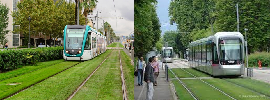
Green tracks in Barcelona, Spain (left) and Grenoble, France (right)
The state of play
Currently the ALR project is meant to be going though a more detailed planning, design and consenting process, with a target to award the main construction contract in late 2025. It’s worth noting that by that point it will have been over 10 years since light rail was first announced by Auckland Transport and eight years since Labour campaigned on it.
Part of the work is meant to include refining the design so it will integrate with other large proposed investments, such as a future line to the Northwest.
And that got me thinking about one of my big frustrations with the project: how it so closely mimics (indeed, duplicates) the CRL, especially between Kingsland and Mt Eden. I believe the modelling even includes luring some trips off the CRL. Beyond the odd accounting, why spend all this money to basically double up on what’s already available?
Based on the maps we’ve seen so far, it appears the plan is something like the map below (note: I’ve also added a potential route for a Northwest line).

Of course, one of the benefits of tunnelling is that you don’t have to strictly follow road corridors. So if we have to have a tunnelled solution, are there options for planning the route to pick up additional new catchments?
Here are couple I’ve been thinking about:
Serving Great North Road
Could we also serve another area where a lot of development is already occurring, with more to come, with a route something like this for the Great North Road ridge:

The big challenge with this would be the grades, but given light rail and light metro can handle steep grades (Sydney’s light rail can do up to 7%) it should be feasible, and with stations shallower than Karanga a Hape will be. The route is slightly longer by about 350m than the current option and with a few more stations would be a little slower, but the trade-off is a much bigger catchment.
Serving the Hospital
Another option could be to avoid Kingsland entirely with a line that looks something like this.

This would pick up Eden Valley, Auckland Hospital (and the Domain) and a better located University station – plus is only about 100m longer than the current plan. The downside here again is the grades around Grafton Gully. Could the line cross over the top before diving underground to get below Queen St? It would also run under homes and businesses most of the way, more than the current plan.
Just to be clear, I’m not really saying either of these options are better than the current plan, or even that we should build them. I’m really just questioning if there are other options out there that could make the current plans for light rail more useful for our city and our times and the challenges we’re up against.

 Processing...
TLDR – No, it’s still a huge waste of 10b+ that could be saved if we just built normal LR down Dominion Road without expanding the corridor AND all the way out to Kumeu
Theres more people on the shore and no rail service.
These people are proposing two train networks for some and none for the rest its rediculous
Why??
The northern busway is better in basically every way than Aucklands heavy rail. The shore is the last place to get to play woe is me.
There are 2 aspects to this light rail I realy don’t understand.
The first is have they not considered a single track monorail simialar to miami above ground on plylons. This could be built down or alonside the motorway and from the airport off SH 20 past mangere bridge to the east alongside the waikaraka cycleway in the sea to then join up to Mt wellington. Alternatively a motorway bridge around that side of manukau harbour like that in bali from airport. We dont need to uproot all the streets like Dominion rd
Its really, really expensive to elevate rail, put in elevated stations, put in 2 escalators on either side of the road, plus lifts for OSH purposes. You also have to take out at least one lane for the pylons.
So yeah, street level and some shelters, thanks.
but is it expensive compared to a tunnel which needs all those lifts, plus it needs a tunnel.
Which is why we shouldn’t be tunnelling.
And good luck getting elevated rail anywhere near residential houses in that isthmus corridor.
I doubt those proposing it would like it right outside their front window….
Great work.
I’ve questioned why they would plan the route parallel to the existing rail from Kingsland to Mt Eden, as you show it’s a wasted opportunity. The Great North Road route makes a lot of good sense.
especially seeing as so much of the case for light metro seems to be that it magically supports more homes than surface light rail.
Even once the stupid “no intensification at Kingsland train station because it might get light rail” goes away, there won’t be any intensification allowed at Kingsland because it’s all “special character” (blue dots) anyway https://i.imgur.com/dMxmiFV.png
Not the Government proposal is not Light Metro. That got rejected.
Light Metro would be 100% Grade separated, able to do 120s frequencies, automated and with platform screen doors.
Instead we get tunneled light rail with none of the above.
Exactly, get none of the above for pretty much the same money – it’s ridiculous
I can’t see any scenario where we’re building a second rail tunnel in the CBD in the next 30 years, we’re still building the first one.
If we are talking about boring machines and not cut and cover I don’t see it being too disruptive (which was the point of not doing a surface route). If you look at the stations being Wynyard, Aotea & the University, I would think only the University one would be disruptive as their’s plenty of room in Wynyard (& not really a through route) and the Aotea box is been/getting done already.
If you think Aotea Station is a nightmare now, try building another Aotea station under Aotea station, and two others in the city at the same time.
It’s not the disruption I’m thinking of, it’s the cost. We’re spending big money on the CRL, there isn’t going to be another tunnel until that is reaching close to capacity. Melbourne is building it’s second tunnel now 40 years after the first as it is reaching capacity.
The space for another station next to Aotea has been put aside in the planning & construction right from the start I thought as a future proofing for a CLR2 station. All the services will be out of the way, and most of the work would be done underground I would think. I could be wrong on that, be interesting to know more about it.
As a lot of commentators have questioned before, there is at least the hint of a question mark over the desire to actually build the light rail when we are presented with a plan for such an expensive, and almost universally agreed, unnecessary undergrounding at such a huge cost.
Why do any of them have to dog-leg to Sandringham Road? Surely a hospital route would make more sense connecting to Manukau Road, Epsom, Royal Oak and Onehunga. Or better yet build a heavy rail link to Mangere and skip out the expensive central isthmus bits entirely. What was the cost of that? $1.6billion?
They all dog leg because Wesley and intended development there. And apparently building a light rail system along a corridor of public railland that would conect Wesley to the Western line and to Onehunga/further, was out of scope.
Whatever happens, they should start at the Southern end, but they won’t.
They have this idea that they can build apartment towers at Wesley get land value capture.
I seriously doubt a few apartment blocks in Wesley will create more housing than you’d get with a surface line with four extra stations in the most desirable parts of the isthmus.
And I seriously doubt the value capture will be anything close to the extra $6 billion they’re planning on spending to try and get said value capture.
The whole idea seems backwards to me. Because the sites at Wesley are publicly owned, they can still be upzoned if the LR doesn’t go there. You don’t need LR on your doorstep, you need the LR to be well-designed as part of a network. And you need to be able to connect to it easily and safely by bike or bus.
LR is a lever to encourage higher density development, so it makes sense to choose the best route by looking at the other considerations, and to be pleased if there’s lots of private land along it. Not to require it to take a dogleg to get to a piece of public land. That’s nuts.
Why stop there with only 1 different mode? . We should build a light rail that connects to a busway that connects to a gondola that connects to a monorail which then connects to the western line. Then people can transfer 4 times between modes between the onehunga heavy rail and the western line heavy rail. Making it all heavy rail so services can run straight through without transferring would be kind of boring anyway.
The University, Hostpital, Manukau Rd, Royal Oak and Onehunga, Mangere would be a good route to do via Light Metro. As much as possible above groups to save on cost. Extend it later for 20,000 pph to the shore.
Dominion and Sandringham roads can be served by Surface Light rail. You get 2.5 lines for the price of the single line proposed.
Heavy rail runs into the problem that the system after the CRL goes in place can’t handle another line with 10 minute intervals. Also Heavy rail has fewer stations due to less flexibility of route, especially gradients.
Or you could use buses for the next 20 years until everybody involved in the current debacle has gone, just like all of the previous light rail schemes.
Because a fair chunk of the Manukau Road route is just Cornwall park and low density Epsom. Compared with stations like Hillsborough, Mt Roskill, Wesley, Sandringham, Balmoral, Mt Eden.
Low density Epsom like Alexandra Park Apartments?
Don’t you start talking sense now miffy. Heavy rail is a phrase you could get canceled for.
If we’re going to go with a tunnelled option, I’m still convinced the best route is furthest east, generally following the alignment of Manukau Road. Long term, there’s probably more intensification potential in places like Royal Oak, Alexandra Park and the (soon to be former) UoA Epsom Campus than there is along Sandringham or Dominion Road.
This alignment would also provide a more direct route to Onehunga and Mangere (making the most of the cost and speed of a tunnelled corridor), and retains the potential to serve Sandringham and/or Dominion Roads with a more appropriate surface light rail option. Finally, it would allow a more logical route through the city, serving the hospital and uni without requiring the strange and inefficient dog-leg that the current proposal includes.
A fair chunk of the Manukau Road route is just Cornwall park and low density Epsom. Compared with stations like Hillsborough, Mt Roskill, Wesley, Sandringham, Balmoral, Mt Eden.
Cornwall park is a bit of a pain but it isn’t right next to the road so there is plenty of room to build things up.
For $15b we should be able to build a Manukau Road Light Metro going South and surface light rail on both Sandringham and Dominion.
The ALR experience stands basically as an object lesson in how not to implement useful policy. Honestly, not a single part of it seems conducive to either the development or implementation of decent policy.
Step One: create local government organisations with regional responsibilities but without the ability to generate funding to meet those needs.
Step Two: have said local government organisations rely on ad hoc decision making by central government politicians (not even agencies, politicians) to secure funding for public transport projects
Step Three: due to institutional design of the local government, it has only one “at large” representative and only loose control of its own local transport agency, which means it’s unlikely the local government will be a source of a policy champion
Step Four: allow the concept of the plan to be hijacked by elites that turn the concept from a bus congestion relief solution into “trains to the planes”
Step Five: continually fail to fire the transport minister when he cocks up or embroils himself in scandals
Step Six: have said transport minister get his head turned by a PPP scheme that is another radical conceptual change of the project (still trains to the planes but now elevated light rail instead of surface light rail)
Step Seven: see the project get cancelled because a coalition party agreed to the original surface light rail plan under protest and now has an excuse to say no to it
Step Eight: create a new team to plan the project from scratch which is formed out of central and local government agencies and overseen by someone with no familiarity with public transport projects (only roads)
Step Nine: have this new team operate entirely independently of the transport strategy plans being developed by the local transport agency
I don’t know if the ALR Team were told they could only evaluate one line or if that was their own decision, but it’s what happened. Either way, we as a society need people to lose their jobs over this… everyone who contributed to the decision(s) not to assess multiple lines is incompetent, no ifs and no buts.
Yes and this now frames every conversation about light rail in NZ.
hospital route good. I wonder if the project include installing platforms for the unserved bend in maungawhau junction to turn that station into a really good transfer hub?
For the southern line? Nope, platforms from the south can never fit at Maungawhau. They did away with that when they dropped the old Newton Station.
Maughawhau is just a regular western line station.
I could not agree more!!! Surface light rail should be the only option.
More reasons:
-Less running costs – the ongoing cost of running/maintaining underground stations with all associated things such as lifts, escalators, CCTV, lighting, security, cleaning will be a large perpetual expense going into the future
-Increased safety – getting on and off LRT at street level means there are more ‘eyes on the street’ all around you at all times, increasing actual and perceived safety, which counts especially after dark
-More convenient 1) – you can actually see when the next tram is coming and decide to jump on, rather than swiping at the station gate and then having to wait.
-More convenient 2) – street level allows stops to be located in the right places to suit the neighbourhoods it runs through, rather than having the stations located where it is feasible to build them
-More accessible – easy and quick access for everyone (step-free access), especially those with different mobility needs. No lifts or stairs.
Women in Urbanism campaigned for street level light rail during the public submission phase. See the campaign here: https://www.womeninurban.org.nz/equitable-light-rail
This whole scenario of arriving at a $15B option to solve a questionable problem is almost too bizarre to believe true. And the costs don’t stop there. To justify the rail line there would need to be very high density housing down either side of Dominion Road. None of the existing infrastructure will cope with this, so further billions will need to be spent on utility upgrades. Concentrating on incentivising high density development (and paying for the also required utility upgrades) around the soon to be completed CRL stations makes a lot more sense. There is more than enough capacity doing this to allow for Auckland City’s growth for decades to come.
… and that’s great for those areas immediately around the CRL, but does nothing for the massive holes in our current network where growth is already happening.
Not really true at all. Drive the length of Dominion Road, relatively low levels of infill high density housing compared with say Glen Innes, Mt Wellington and parts of West Auckland. My point is there is a limited budget for PT, why blow $15B on a single line when we have CRL coming to completion, lets intensify there. Also NW crying out for a dedicated bus lane, way more important than ‘peak buses’ on Dominion Road.
The $15b plan doesn’t even go to Dominion Road. For some inexplicable reason they’ve sent the tunnel under sandringham road, which is less desirable, has less demand and is further away from the direct route.
“None of the existing infrastructure will cope with this”
Citation needed
Agree, there’s lots of hysteria from councils over this but watercare is great, huge capacity is being added right now. If you handed them 10s of thousands of new households to charge water rates to, then there would be absolutely no issues getting capacity there.
And obviously the whole conversation is predicated on the enormous transit line.
“Starting with surface routes doesn’t mean we can never build a tunnelled option”
This 100%, the irony that a PT project ‘has’ to project out to 50 years worth of growth to be worth while is crazy.
Would the motorway network gotten over the line if it ‘had’ to be built 4 lanes wide, with the Victoria Park tunnel etc etc. No, it was built then added to. Very similar to the harbour bridge analogy this site has used before.
Why does this particular PT project have to be gold plated, even the heavy rail network has been improved slowly over the last 25 odd years.
Surface LR on 1 of the inner isthmus spines (Dominion, Mt Eden, Manukau, Sandringham) … then begin expansion IF required, easy to add another spine out of the above 4 routes …
Get on with the NW LR, get on with an upgrade for Northshore, A2B … All these other worthwhile PT projects that are going to get stalled due to a tunnel option sucking money from all available sources.
It’s not just this particular PT project that is gold plated, it is also the NW and NS lines that will use this tunnel. I kind of feel like making all 3 of those lines surface through the city would be a mistake, especially when 2 of them will be have no other surface level on the route. So do we build the tunnel now, or wait until we build the NW or NS, or build surface for all three and then build the tunnel? To me building now makes the most sense.
Ok but why does the tunnel go out to Mount roskill via the arse end of Sandringham then?
The northwest and north routes run to the CBD, not south of sandringham.
Plus, if the first line is gonna cost $15b+ do you even think it’ll get built, let alone the other two lines?
Sure, if by the time we’ve built the three lines and the city surface route is congested, then build a second city rail tunnel. But even the ALR people said the Queen street line wouldn’t run out of capacity until sometime after 2050.
So why spend billions extra up front on something that isn’t needed for another three decades? Are the ALR people really so economically illiterate?
To answer the question.
No.
The turd might be slightly shinier but it’s still a turd.
One of the key reasons for tunneling vs surface was the controversy over business disruption in Albert Street. These are not directly comparable. Albert Street has required deep excavation (15m plus) for most of the road width (15m plus) for about 4 years. Surface light rail would require relatively shallow excavation (say 2m) for only part of the road width (5-6m) and for a much shorter time at any given spot (a few months versus years). Granted, there are underground services to be worked around or relocated but they did all this in Queen Street about 12-15 years ago and nobody died.
The effects on Albert Street were all known at the time of the designation but they were ignored to save a small amount of money. The CRL team preferred to externalise those costs and got away with it due to the public trusting them. That trust is never coming back.
I see a massive opportunity to run the line from a tunnel under Wellesley st and above ground up Grafton valley alongside the motorway as far as Grafton bridge before going underground again.
A station could be placed in Grafton valley to serve the university’s and the hospital.
The gradient is 2.7% from 10 metres below queen st, I know there is a large stormwater pipe under queen st I’m not sure of it’s depth.
This whole thing gets more absurd by the day.
Just build surface light rail on Dominion Road or Mt Eden Road. Use the money saved to build to the north-west.
Then if those lines reach capacity, look at a tunnel. Guess what? They won’t reach capacity for 20, perhaps 50, years.
And by that stage we’ll have bigger problems to worry about, like Britomart being underwater.
Both alternatives are better than the current proposal (except the second one makes NW harder potentially).
This whole proposal is bonkers though. If you’re going to tunnel and spend that sort of money, you should do what Sydney has just done and build a proper metro for roughly the same cost but with 2-3x the capacity (and a much nicer user experience). Failing that you go the Vancouver Skytrain route which would be cheaper and you get to enjoy the views.
+1, or a hybrid of both. Tunnelled through the isthmus and elevated along the NW and SW motorways. If you pay metro money, you should at least get a metro!
Exactly! Skytrain is partially tunneled into the inner cbd.
Another consideration is the housing moratorium need so that the land that can be TOD around stations can be protected from low to medium density rebuild before high density can be economical. Build high density first, and nobody can travel. Wait for a tunnel, and nobody can build until they can travel. Surface LRT soon would allow economical high density and medium density. Character home owners will be queuing up at the agents to sell to developers.
I like the hospital route, makes much more sense if we are going to tunnel, should get a lot of use and less of a dog leg. This then means any north western line would have quite a different catchment. So this line the NW and heavy rail routes distinct catchments.
You could surface about the Eden Valley Station and run surface along Dominion Rd, then on to airport as per more the original designs.
Sandringham, Dominion, Mt Eden, Manakau are mostly 2 lanes & footpath. The http://www.lightrail.co.nz brochure surface examples are wide lanes with cars, rail, greenery, bike lane and wide footpath. But that’s not possible for much of the surface route due to the width.
The surface option with removing car parks and road space is a hard sell, public resistance would need some strong willed politicians. I feel that’s the real reason for the tunneled selection.
Completely agree. While a number of politicians have in principle supported light rail down Dominion Rd, there isn’t one in a position of influence that would go in to bat for the transformation of the road that this would involve.
What? Those roads are mostly two lanes, plus two lanes of parking/bus lane, plus a median strip, plus footpaths, plus berm.
Sorry, aren’t these roads that literally used to have trams running down them? Suddenly they can’t support trams? Are the roads narrower than they were in 1940s Auckland or something?
The point was they can support surface light rail, but it will need reallocation of road space, and with that comes opposition. This isn’t a technical limitation, it’s a political one.
It would have been interesting to be a fly on the wall in the meetings when evaluating the extra cost of tunnel vs the push back of surface rail.
Moot point, if the current polls hold (and they probably will) Light Rail is gone for at least the next decade, probably the next two, in any form. In fact they seem to dislike the surface option more than the tunneled so the reduction in cost wont save it.
The Nats have to find billions to fund the tax cuts that are central to their platform (including the regional fuel tax) and they were planning on cutting this even before the tunnel option was mooted anyway. Barring a miracle no light rail for Auckland for a long, long time.
Depends which poll you look at. Kanstar has National in government, Roy Morgan has Labour, while Curia has a hung parliament and us going back for another election. It is going to be extremely close.
Yes thats true. Just feels like there has been a momentum shift. Long time to go I suppose.
It is a long time. I think this is normally a good time for the challenger party, the party in power are normally saving all of their achievements up until the election. It could go either way, but had Labour actually started surface level when they first won the election it would now be in progress. In saying them I prefer the tunnelled option, but I prefer surface over no option!
And the best we will get will be a bus stuck in traffic.
It’s a real shame this government got nothing done.
Unfortunately it looks like there is no government that could get something like this done.
While they propose heavy rail being extended through Mangere, the solution to serve Dominion Rd is likely to end up being surface LRT as it’s the cheapest solution and argueably offering the best service to those enroute, replacing buses.
Hopefully the city end of the route follows the old tram route via New North Rd allowing transfer at Mt Eden station and via Symonds St to universities and Britomart.
To the south it might also cross and connect with future passenger rail operating on the Avondale-Southdown freight route. The combination of these two rail lines would serve Mt Roskill intensification better than the current circuitous single line.
Further to the south it could cross Richardson Rd and terminate at Hillsborough Rd, connecting with buses on each.
The tunnel doesn’t serve Dominion Road.
Best case for dominion is we keep the existing busses with their frequent fast peak hours service (252/253)
Worst case for dominion is they scrap the buses into town and replace them with feeders to the light rail stations. If they do that, for most people, that it will be quicker to walk to town.
When the CRL TBM has finished its boring, can we please borrow it to do a tunnelled rail extension in Wellington. Then when that is done, Auckland can have it back for their second sub-city tunnel. A rolling program of these projects would make them all soooo much cheaper.
Good idea Dave B – what would your preferred route be? And are you one of those that propose extending the Heavy Rail line through Wellington, to the Airport / Island Bay – or are you a proponent of changing one of the existing real routes to Light Rail, and so extending the Light Rail through the city and out the other side?
Nemo, thanks for asking. My suggested route would be:
– Along the quays, either at-grade and landscaped-over (if the powers that be can bear to reqlinquish this route from road-traffic), or else tunnelled at the same level as the various building-basements and underground carparks along there. Station next to Civic Square.
– Cut-and-cover up Taranaki St until ground rises enough to allow boring. Stations beneath Courtenay Place and next to Pukeahu Park.
– Bore a sweeping arc under Mt Cook, not-quite-surfacing at Newtown, then continue under hill to Kilbirnie. Station beneath St Anne’s Park and precinct in Newtown.
– Assume corridor of Leonie Gill walkway to Rongotai, either emerging from tunnel at ground level (with Onepu Rd ramped up over railway), or else emerging at flyover-level (over Onepu Rd) then on a descending viaduct to Rongotai. Stations beside current bus-barn at Kilbirnie (level or elevated), and alongside Rongotai College. The latter would be in a descending cutting.
– Descent to allow passage beneath airport runway and Stewart Duff Drive, then form a single-track “balloon-loop” under Miramar Golf-course and a short curving tunnel beneath Strathmore Hill, to a station adjacent to the airport terminal. The line would then curve back into the Airport Tunnel as the return track. Wellington Airport would need to alter their current plans to allow this.
I am not a planner, architect or civl engineeer. This is purely a suggestion that looks feasible to me.
I strongly propose extension of the existing (heavy) rail system, such that this extension would form an integral part of what the region already has. The aim would be to extend the entire regional rail service, either all-the-way to the airport, or allowing some trains to turn-back at a central turnback-platform at Newtown. This project would address regional issues and “join the region up” far more than a separate local light rail line or any other current proposals would.
Got it. Using PT funding to build sea walls (thereby underplaying its primary purpose) seems like the next logical step for Wellington.
I would assume the TBM is leased and will be sent back to manufacture for restoration and quickly reused in one of the many rail projects around the world.
Probably Lome LR or metro in Australia.
Except, John M, that this TBM was designed and sized specifically for Auckland’s application and network loading-gauge. I am sure this would be appropriate for Wellington also, but may not fit other countries’ requirements. Interesting question though – what will become of Dame Whina Cooper TBM if it is not redeployed elsewhere. I understand that in some tunnelling projects, the TBM just bores its way off to the side somewhere out of the way and is then abandoned, having effectively dug its own grave. What a waste, if that’s ours!
Yes, that’s what happened with the TBMs digging the British side of the Channel Tunnel – the French dismantled theirs in the tunnel and took them out to re-use on another project.
I think there is a fair degree of rebuild that has to happen at the end of each dig, as the machines have been working hard. New teeth obviously, but also lots of other bits will be a wee bit knackered. And so, you have to spend some money ready for the next project – but that’s still cheaper than buying a whole new TBM.
I believe the total diameter of of the CRL TBM is only slightly larger then the tbm’s currently being used to dig Sydney’s metro lines.
But yes each TBM is a custom fitout for the tunneling conditions. Like the cutting head and many have a pressurized space around the cutting head for digging below sea level example.
I do wonder what happened to the TBM that did the waterview motorway tunnel.
I’m pretty sure the cutterhead and shield is generally cut up in place at the end of the job. The cost to transport it back to the manufacturer, for something that is unlikely to be useful for any other project, and is likely knackered, would be more than that part is worth.
More complex smaller parts like the main bearing are returned, and the contract and price (13.5 million nzd) for the whole tbm is dependent on these more expensive parts being returned.
The total cost for the TBM itself for the CRL project is 13.5 million NZD, vs ~5B for the total project. (reference linked below if you don’t believe me)
A rolling program would make things cheaper, but on the TBM front… no not really. They’re pretty cheap in the scheme of things. Staffing, materials, consumables, the supporting stuff like the ring segment plant, surface buildings, tailing handling, transport for all the above all have to be way more expensive than the use of the machine itself.
It’s essentially a collection of separate plants that are either designed solely for this project and used up at the end of each project, or are mix and matched onto new TBMs for specific conditions on other jobs. This specific collection would be very unlikely to be useful on any other tunnel project in NZ, way better to get a new one designed for the job. Plus everything is priced based on parts being returned at the end of the job.
https://www.cityraillink.co.nz/tunnel-boring-machine-key-facts
Yes this discussion about reusing boring machines to save money keeps coming up and is quite frankly rather boring.
Needs to be put to bed. This conversation crops up everywhere.
I think nobody that works for the projects ever quells this myth that they’re expensive machines because the natural follow on question is “well where does the money go then!!!”.
I own a property which is about 100 metres from one of the proposed light rail stations (proposed at least according to one plan).
It was my plan to build a block of three-story walk up apartments in this location, possibly with retail on the ground floor, but the uncertainty around the light rail and the zoning has left me frustrated on how or whether to proceed with this.
The most likely outcome at the moment is I’ll bowl the aging two-bedroom house on this property, subdivide and build two two-story McMansions, flick them on and be done with it. This is what I’ve seen my neighbours do – it seems to be the only logical thing when the council/government/AT/whoever dilly-dallies and flip flops over plans for key infrastructure for YEARS AND YEARS.
Can you tell I’m frustrated? If they want density, they have to make a decision on the infrastructure to support it. Otherwise you’re going to get low-density new builds around these areas. Basically the worst result, all because the powers-that-be can’t make a reasonable decision.
I would say if you can finance it just Go for the higher density option, it will have a higher return regardless of the station being there or not.
Oh..don’t forget to cover it in yellow and brown brick to make neighbourhood mad.
Just something developers like doing these days.
Wait just 6 months more. Decision will be made by then. Labour will want to get this as sewn up as possible before the election next year.
They said last week that they want the main contract signed in 2025; so they need to win the 2023 election first.
Most of the cost of going underground is actually going to be shared by 3 lines (NS, NW and Mangere) not just one. If they did 3 above ground lines then they would need 3 different routes through the city because a surface line would have no where near the capacity for all 3 lines, that may actually cost as much as one tunnel And if you add up the extra journey time over all 3 lines being above ground in the city, that is also quite a cost and barrier to use.
Saying the $15 billion is all for the Mangere line seems a bit unfair, similar to attributing all of the cost of the CRL to the western line.
This is a good point, though they are looking at tunnelling most or all of Sandringham Rd aren’t they? So much fear of loosing a traffic lane or two and on street parking.
I think the point is once you tunnel some you may as well tunnel all. But for some reason they aren’t applying that logic at Mangere which is really odd…
Cos tunnelling is always more expensive. Running a train/tram/metro on rails next to the existing motorway is always going to work out cheaper – but unfortunately goes where the cars want to be, not where the people want to be…
We are talking about the town centre in Mangere. Maybe they think there will be less opposition to a surface route in that section or they won’t need cycling along that part as well.
“the point is once you tunnel some you may as well tunnel all.”
Yet we never apply that to any other project. Tunnelling is always more expensive, so something to be minimised. There is always oppourtunity cost. Like doing the NW line or not doing it.
The cost of tunnelling a NS line and/or a NW line is addtional cost.
The portion of the tunnel that will be use by both the airport and north shore line is tiny. Even the NW line wont use Mt Eden to Mt Roskill which is a fair chunk of it.
Once you start looking at a possible route for the North Western, their city end of the route does make sense.
2nd harbour crossing link to/where/when
We already have a second crossing that fulfills disaster redundancy requirements.
A third crossing is unneeded for some time. Plenty of room left on the busway for people carrying capacity. And last time I checked, the bridge isn’t chocca with trucks only.
It does no such thing. The second crossing (WRR) is already at capacity during peak periods and busy enough the rest of the time. Yes technically in a disaster/emergency it does provide access to/from the North Shore, but it in no way is an adequate redundancy for the AHB. Auckland needs another harbour crossing – even if it is just for PT.
It is adequate redundancy. The point isn’t to have zero disruption if the single most important piece of infrastructure the city breaks. The point is to ensure the flow of goods and people at a high enough level to let the country continue until the bridge is fixed. Allowing the continuation of the most critical subset of trips.
And as we’ve already seen the AHB is also 3 seperate bridges with significant redundancy all on its own.
Sure another will be needed. But the north shore already has 2 redundant, fully independent motorway crossings, and the busiest PT line in the country.
Give it a decade, and build more important infra first
The busiest PT you refer to is reliant on the AHB, without it the line is effectively useless.
The UHH is not even half the capacity of the AHB (and as mentioned most of that capacity is already used). If the AHB goes out you’re not going to get much through at all. The AHB is also nearing its use by date to an extent so even if not adding more driving lanes, another crossing of some form will be needed.
The redundancy scenario is an extreme one, no one is going to be spending $5 – 10b on a backup just in case the bridge collapses.
In this extremely unlikely event buses and trucks would be prioritised on the Upper Harbour Bridge. It wouldn’t be ideal but extreme events generally aren’t.
The capacity is probably more limited by the NW motorway bottleneck (unreliable due to it’s length too) more than the bridge itself.
Past it’s used by date?? The engineers in charge of maintenance will be surprised to learn that.
The NZTA makes very clear statements, “Our programme … means the bridge is able to operate indefinitely as a key strategic asset in the Auckland network“.
Get rid of the heaviest trucks from the outer lanes and the bridge will last as long as they keep painting it.
https://www.greaterauckland.org.nz/2021/03/01/the-harbour-bridge-is-not-falling-down/
Measuring “capacity” by seeing if there is congestion on that route is silly. In a disaster scenario a good subset of normal trips will not happen. We’ve literally had a real world bridge outage scenario recently, Auckland did not implode. Adding a couple more lanes across the harbour would not help this hardly at all. They would be saturated from day 1 regardless.
Needed soon? If soon is 15+ years then sure. Otherwise you have the job of justifying the 0.1BCR 10+ billion project. Would be quite literally the single worst large project the country has ever undertaken.
Should’ve just gone with the NW route first to prove it works. Far simpler, cheaper, and along a route needed now. Then waited until the isthmus got jealous and actually wanted a project for it, as the NW line would reduce buses going into the CBD enough to give more time for the isthmus to figure out what they want.
Yes.
North West Light rail would be a great way to prove climate change deniers wrong. In 20 years time and after spending 10 billion we could stand proudly and righteously and say “look, I told you it would be underwater”.
the tunneled alignment goes straight through a basalt lava field which is anything but easy or cheap. Plus there will likely be the added constraint of unknown lava caverns under the isthmus meaning they have to do the tunneling super slowly to avoid losing the TBM into any large aforementioned caverns. This is why the price of the tunneled option is so expensive per km compared with overseas examples. The ithmus actually seems like the worst place you could want to construct a tunnel.
Adding to this, you don’t want to stray form road alignments as this will trigger further property acquisition and increase costs.
Why not run the light rail down the land, designated for the heavy rail, from Mt Roskill Pack N Save (parallel to the south western motorway) to Onehunga and onto the Airport, then out to Puhinui, it would connect the western and south rail lines.
The lands already available and alot of the overrides already built.
Why not run heavy rail down the land designated for heavy rail to connect the heavy rail in Avondale with the heavy rail in southdown? Why force a transfer of modes?
What have people got against transfers? Thats how a network works.
And if you don’t have a problem with transfers, why does mode matter? Frequency, speed and reliability should matter.
oh. And cost.
You certainly don’t complicate things unnecessarily. This is an unnecessary transfer you are arguing for. Your argument is not logical. just because people accept hindrances in systems doesn’t mean that it’s fine to add those hindrances in all over the place when they don’t have to be.
If we take your advice maybe we could have a busway from southdown to onehunga,
then a monorail to Hillsborough, then a gondola to Mt roskill and finally light rail to Avondale. People can transfer each time. Apparently that’s how all networks work and people won’t mind? .
The route from Avondale to southdown has been designated heavy rail for 60 plus years, we already have the rolling stock, drivers, mechanical resources, skills, admin and safety standards to run on it. It connects to existing heavy rail at both ends already. All we need is the track. It may not end up being cheaper to build light rail track and then build an entirely new industry around it with different forms of everything above.
If Northport takes off too then the a-s will be required as heavy rail. Would be embarrassing and costly to have a light rail and heavy rail line running right next to each other. Just build it right the first time.
Transfers are going to happen at Southdown regardless. It won’t “connect” to the southern line (not unless we want poor frequencies), it will connect to a station and there will be transfer options.
To suggest it has to be HR is just mode bias.
Ah here we go. “Anyone who disagrees with me has an inherent bias” . Classic stuff.
personally it would connect to the eastern line and the inner west line. So city-panmure-onehunga-avondale- kingsland-city circle line. So the entire isthmus can be connected without a transfer. We could run cross towns manukau to Henderson. We could have freight connecting through Avondale without 700m long freight trains crawling through Newmarket at 25kph and Importantly we keep one set of rolling stock, one set of mechanics/technicians, one set of everything which we already have.