Following the release of the government’s decision on Light Rail two weeks ago, the Auckland Light Rail team (ALR) released the Indicative Business Case (IBC) used to make the decision and although some of what are probably the most interesting parts of it are redacted, and they still haven’t published the appendices, there is some useful information in it. At the same time what is there often raises more questions than it answers.
Some of the information is from the business case we saw in October when a summary was released, so in this post I’m focusing on parts of the IBC that we haven’t covered before.
Stations
We’ve complained before, including two weeks ago, about there not being a clear picture of where stations will be, only showing vague information. This is ridiculous as they have to know where they are so they could model usage. ALR redacted images in the document that might show the station locations however they did miss one. In a section about places of significance for Māori they include a map showing places along with the potential Light Rail and Light Metro options. It appears to show a dash for locations with stops with either mode and a dot for additional stations under the surface LR options. This highlights the following stop locations for Tunnelled Light Rail
- Wynyard – On Gaunt ST
- Aotea
- Universities – but based on the position on the map is actually up by Wakefield St so not really any closer to the University of Auckland than Aotea is.
- Dominion Junction – Where the Dominion Rd/New North Rd junction is
- Kingsland
- Sandringham Rd / Balmoral Rd intersection
- Sandringham Rd / Mt Albert intersection
- Wesley – between Stoddard Rd and SH20
- Mt Roskill – at Dominion Rd
- Hayr Rd
- Onehunga
- Mangere Bridge
- Coronation Rd – close to intersection with Walmsley Rd
- Bader Dr
- Mangere Town Centre
- Landing Dr – is this just about serving the airports Park and Ride site?
- Airport North – I assume somewhere around Manu Tapu Dr / John Goulter Dr
- Airport

The other thing of note with this, with stations so far apart, there’ll still be a need for buses on the Sandringham Rd corridor in order to help those with less mobility get to stations. This undermines one of the key reasons for initially investing light rail to begin with.
Routes
As to how they got to this route, the IBC includes mention of a long list of potential options that were assessed at a high level. For mode they looked at buses, trackless trams, light rail, light metro and heavy rail, we saw the result of some of this back in September. For routes they broke this down to four sections:
- Section A: Airport to Ōnehunga
- Section B: Ōnehunga to Mt Roskill
- Section C: Mt Roskill to New North Road
- Section D: New North Road to Wynyard Quarter,
The routes that were considered in each segment are shown below.

There isn’t a lot of detailed information in the IBC as to how they assessed each of these options – that is in an unreleased appendix – but they shortlisted the options to light rail and light metro with the routes being on Dominion Rd and Sandringham Rd. This is no surprise given these were the two modes and two routes the government told them to look at.
One thing I find extremely disappointing is they’ve only looked at solving the transport problems through one line. For example in a list of risks they include
Developing a rapid transit solution that does not optimally integrate with the rest of the RTN may lead to future cost in other RTN projects and inefficient sequencing.
Additional lines do cost more but are also more likely to end up as a greater benefit than just one line. It’s disappointing ALR didn’t look at some multi-line options for the same price as the tunnelled option they recommended.
The shortlisted options, plus the chosen tunnelled light rail are summarised in the table below

A few things that stand out to me from this as well as a few of the other comments related to it in the document.
- The Sandringham alignments are preferred due to serving Kainga Ora land at Wesley and having an additional station. They note that for the metro option the additional station results in an extra 7% in ridership in their models.
- On stations, the IBC notes:
However, with the Light Metro and the Tunnelled Light Rail options it would be harder for people with physical mobility issues to access the underground stops/stations. So the Light Rail option is more equitable for those people.
- The downside of that diversion to Sandringham Rd is it adds about 1.4km lengthening journey times. Though I suspect there’s an error in their model here as it adds two minutes to the Light Metro option, which seems about right, but only 1 minute to the light rail option.
- I doubt the travel times have included how long it will take to get down to the platform level for those underground stations, these could easily be as deep as a 10-storey building.
- It’s not clear why the Light Metro option on Dominion Rd costs quite a bit more than the Sandringham Rd option, tougher geology?
- Surface light rail on Sandringham Rd was ruled out due to the need to move a major power cable, probably to Dominion Rd and resulting in two years of additional disruption.
Speaking of disruption, the IBC puts a lot of weight on the potential disruption of the surface option while almost dismissing the disruption for the tunnelled options. For example:
The Light Rail option will result in disruption along the entire route as the surface running tracks and facilities are put in place. This will result in disruption for long periods of time, perhaps 3-5 years, in important areas such as Queen Street, Fanshawe Street and Dominion Road. There would also be similar impacts through the town centres of Ōnehunga and Māngere. The Light Rail option will also likely result in ongoing restricted access (left in left out access only) to properties and streets along the route.
There will also be disruption during the Light Metro and Tunnelled Light Rail implementation. Due to the tunnelling of these options through the city centre, central isthmus and Ōnehunga and Māngere town centres, the level of disruption for these areas is significantly reduced. There will however be considerable disruption at the station locations and at the tunnel portal locations
Firstly, most overseas surface light rail systems are delivered in 2-3 years. Second, it’s hard to see how even building deep stations, like we’re doing at K Rd, won’t mean significant disruption to places like Kingsland, Balmoral Rd. And it’s even hard to see how mining and joining in a second station to Aotea is not going to be significantly disruptive to the city centre and the city’s critical Wellesley St corridor.
Capacity and Ridership
The government have talked a lot about how their decision for the tunnelled option is about future proofing the corridor. So it’s notable then that the tunnelled light rail option clearly has significantly less maximum capacity than the metro one. This is important as if the network is built out as currently planned with the Northwest joining in to this route through the city, this maximum capacity will need to be shared between the two lines.
There are also some interesting graphs on their peak hour modelling forecasts vs future capacity. The bars on these graphs represent the seated and standing capacity on trains. The dotted lines represent demand based on a general uplift in land use from improved transport while with the solid line comes from a programme to deliver higher levels of intensification. Perhaps the most interesting thing about them though is it highlights the steps that would be taken to increase capacity over time, such as improvements to frequencies.
The surface light rail option suggests we could eventually move to 3 minute headways on the route

Light Metro could go as high as a train every 90 seconds, which with trains holding 580 people each could move over 23,000 people an hour. This is also notable as elsewhere in the IBC they note this – which I assume they’re talking about just the parts on the CC2M corridor:
Once the CC2M is connected to future extensions to the North Shore and Northwest, patronage is forecast to increase by around 20-30 percent.
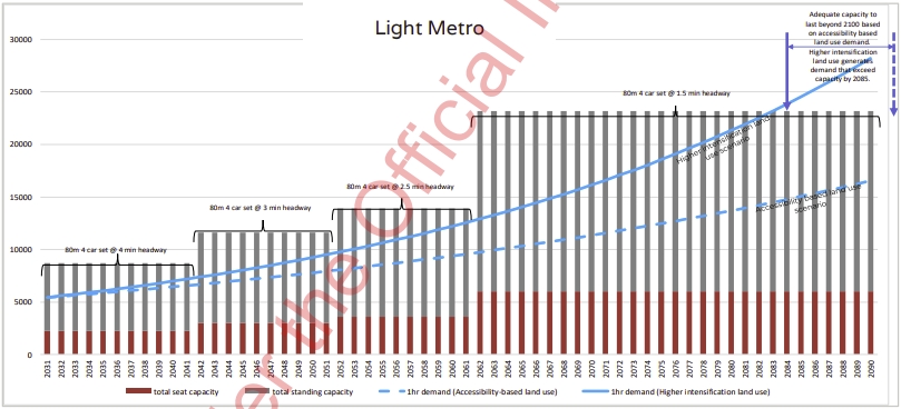
The government praised the tunnelled light rail option for being able to move 15,000 people an hour. That doesn’t quite match up with the table earlier though which states a maximum of 12,600 per hour. The plans seem to indicate light rail vehicles will be about 66m long and carry 420 people per train and would run at twice the frequency in the tunnel section – every 2 minutes – to achieve that. Interestingly to get more capacity in the future this graph suggests in future there could be longer 80m light rail units. But given they’re also running on the surface sections through Onehunga and Mangere, why aren’t they also in the Dominion Rd option?

On ridership, we’ve seen before estimated usage with 2051 forecast annual boardings at:
- Light Rail – 22.3 million
- Light Metro – 34.95 million
- Tunnelled Light Rail at 31.2 million
One thing that the IBC doesn’t include though is what this means for ridership on the wider public transport network. For example, how many trips are these options diverting off existing trains and buses, equally, how many of those trips are transferring from bus.
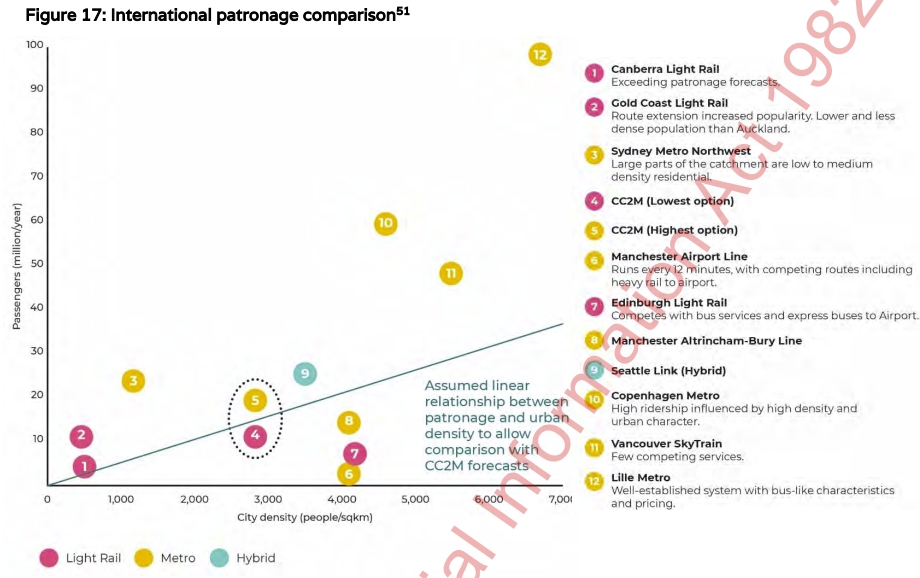
The IBC includes graph comparing their estimated ridership and density based on other cities.
OPEX
One big thing we were missing from the cost information released in October was the operational costs. These costs are the average annual value and it highlights that the Tunnelled Light Rail option has the highest operational costs though I’m surprised they’re so close. I also note the light rail and light metro figures are both $104 million in the paper that went to cabinet.

They’ve also included an estimate of farebox revenue based on our current (and planned) fare structures.

Active modes
The IBC talks about how the options will all benefit active modes too but there’s no guarantee that active mode improvements will be included, in fact I’d suggest they’ll be one of the first causalities of the value engineering stage.
All options increased active modes (e.g. walking and cycling) because they increase patronage and intensification along the corridor which means more people to walk to stops/stations.
The Light Metro option and Tunnelled Light Rail option are partially underground so theoretically there will be more space on the surface to provide for cycling (specific designs have not been undertaken). The Light Rail option will also have space for cycling facilities, albeit in a ‘busier’ surface corridor.
Theoretically I can ride a unicorn to work and theoretically there is already space on the surface to provide for cycling so why not get on with providing that now?
There’s plenty more information in the IBC that I haven’t covered, if you’ve taken a look is there anything that stands out to you?

 Processing...
Can they really not find a solution to have light metro through Mangere town centre so we can just go balls to the wall automated metro? Really???
+1 seems ridiculous to spend all that money only to skimp a fraction and end up with a slower, lower capacity and more expensive to run system.
A related question, why is it essential to tunnel under the rich suburbs of the isthmus, but come to Onehunga and Mangere it’s essential to run at street level through the town centres and neighbourhoods.
Which is it, is it a tunnel to avoid disruption, or is it surface to serve communities.
All the business about disruption and traffic turns, they don’t apply to the poorer, browner neighbourhoods of the south, just the waspy villa belt?
And are they really not going to build the stations to fit much longer (120m etc) LRT vehicles in the future?
Agree, is there anything stopping a light metro vehicle being the same length as one of our trains? Obviously they would have to spend more on stations but building for 80m has the potential to be a serious limitation in the future.
If it was LM with 90s headways, 80 meters is heaps. The Canada line in Vancouver with 50 meter platforms has a design capacity of 15,000 ppdph. A bump up to 80m would bring 24,000 ppdph.
Which just goes to show how of an underperformance the heavy rail network is, at a max ever capacity of 27,000 ppdph. And that would be after all the signalling upgrades and station lengthening up to 210m platforms.
We could legitimately save on station costs by going to LM over tunnelled light rail with the much shorter platforms the signalling allows.
I agree.
Looking at the REM line they are going for 76m long trains with a capacity of 780 people, and running them even 2 minutes.
More than enough.
That 780pax capacity for the Montreal REM is crush load; 600pax may be a more realistic capacity measure.
Re. heavy rail capacity; I believe it could be a bit higher. If the train interiors were reconfigured with more high-density longitudinal seating, a 9-car train may be able to fit 1500 passengers; with long-term 24tph through the CRL that may give a capacity of 36,000p/h/d for the heavy rail network. (Whether AT choose to have that in their scope, however…)
My gut instinct is that light metro would still be better off future-proofed for ~120m long platforms and trains (900-1100pax). That, plus 90 sec headways would give a capacity of 36,000-44,000p/h/d.
The more I read about the tunnelled option the more it seems that it was selected for all the wrong and/or political reasons.
I do wonder how much disruption there is on Dominion Rd when major road repairs are required, which when you think about it is kind of what ripping up the road to strengthen and lay the light rail line would be equivalent to.
If there is a need to buy land to facilitate the stations and to create value uplift, then not announcing the precise route and station locations is sensible.
They still don’t get it.
“The Light Rail option will also likely result in ongoing restricted access (left in left out access only) to properties and streets along the route.” Yes FOR CARS. Not for people walking to the light rail stop, not for people on bikes, not for people strolling to the shop… Also as someone who grew up in a city with trams, turning left is not a big deal anyway.
The whole point is to move the focus away from cars as the default mode and the language used makes it clear that the wrong people are steering the ship (so to speak).
Can we just do left in left out please? On the dominion road route even though it’s not gettign anything, getting left in left out would be an easy win to improve the neighbourhood.
I live on Dominion Rd. It can easily take 5 minutes to turn right across traffic even during non-peak times. It wouldn’t make a big difference to most people.
It would actually be easier. Assuming it runs like other light rail streets where you can make a u turn at the lights with the right turn phase, it’s easier to go to the end of the block and come back and go left into the driveway than it is to try and turn right across it.
Good to hear that local knowledge.
I want to begrudgingly support this project, but when I hear something like there will still be a need for street busses along the corridor, they are not making it eazy.
To me this is no flaw. Having a need remain for buses means they will be forced to build a second line at some point in the (hopefully not to distant) future, as buses clogging the CBD was the original reason for light rail being proposed back in 2015. I see this line as a fast tram line as part of a mostly on street yet to be built wider network
The need for surface busses along the corridor is a symptom of how far this project misses the mark. Zero land being available for bike lanes on natural bike corridor is just the cherry on top.
Thank you so much for this post. I’m keen to have more posts here about the light rail line.
I consider it important that the station locations (besides those publicly anounced like Aotea, Kinglsnad, mangere Town centre) be chosen through a public process. I do have some strong locations on some. I believe a station should be built right under or as close as possible to St Lukes, not the Sandringham/Balmoral interchange. I do like the idea of directly under Cornwalis Street as the site of the St Lukes station (the tunnel proposal makes this easy). I also consider three stations between Aotea and Kingland to be ideal, with one under Newtown/Upper Queen Street being good. The possibility of one near the corner of Upper Queen Street and Alex Evans Street near St Beneficts Church is good and can be connected by a pedestrian tunnel to the Karangahape Road Station.
I do consider this light rail line as just the start of a wider light rail/metro network that should hopefully include surface light rail on Dominion Road and Manukau road in the future.
Regarding the future I think its important that the driverless light metro not be ruled out, especially if this line is to be extended to the North Shore. In that regard when we do extend to the North Shore we can also build a 7km tunnel direct from Mt Roskill straight to near the SH20A Kirkbride road intersection turning it into an airport express light metro. The Mangere-Mt Roskill bit can be a semi-orphan line until we do surface Dominion Road. Anyone know how feasible a future conversion to light metro and Mt-Roskill to Mangere tunnel will be?
Fully agreed re St Luke’s being a stop. It’s planned to be the biggest shopping mall in NZ (although Westfield decided to put Albany first). It needs rapid transit far more than a corner that has a petrol station, a gym and a few houses (that are already well served by buses).
I think re conversion later to light metro, it’s better to do it right first now, by actually building it as Light Metro.
The proposed station at the University has huge potential to tie in with Bill Reid’s tunnel project under Albert Park. Huge opportunity to create a landmark in Auckland. Very excited about this and it’s a station that was actually proposed by this blog years ago – although this blog’s suggestion was it join up with the southern rail line at Newmarket.
It always makes me chuckle that they call these reports ‘business cases’. As if any business would ever consider spending so much to gain so little.
I’m curious miffy.
What projects would you legitimately like to see?
Cheaper projects that will actually be built rather than expensive virtual projects that we know will never happen but are used by politicians as diversion like tawdry magicians.
Agree. Planning that creates incremental improvements this year, next year, the year after that – and in multiple places around the city. Working towards a network that is sound in principle, but not relying on hypothetical benefits of several decades away to justify mortgaging the kids.
I agree too.
This all sounds fishy and bad faith. The NZTA team come up with a fifteen billion buck megaproject after years of delay and dodging, have they set this whole thing up just to sink it.
Meanwhile they crack on with their motorway programme slice by slice, few hundred million for a widening here, billion and a half for an extension there, year in, year out.
Yes decrementally improving things.
The Light Rail option will also likely result in ongoing restricted access (left in left out access only) to properties and streets along the route
That’s a feature, not a bug. Being able to right turn willie nillie onto or off busy arterials is a crazy thing to have. Almost all the near misses I’ve had are people rushing across multiple lanes of traffic to make a “gap”.
+1
There’s no “right to turn right”. It’s embarrassing that this even rates a mention as a potential negative. Imagine if they decide to consult on removing right turns in and out of driveways in the same way they do with the removal of on street parking spaces…
The whole thing leaves me with a creeping sense of dread. I just don’t think we are going to see it built.
“Due to the tunnelling of these options through the city centre, central isthmus and Ōnehunga and Māngere town centres, the level of disruption for these areas is significantly reduced.”
I’ve not seen tunneling thru Onehunga mentioned before.
The ALR team should talk to the Huia 4 watermain team. There is significant ground water around Onehunga. Plus HARD rock. They were blasting up my street forever a few years ago.
Waste of money and bop has a light rail that works as well as heavy rail
<i All options increased active modes (e.g. walking and cycling) because they increase patronage
It is good to hear acknowledgement of this fact at least. The catchment increases are massive when you can bike, park your bike, and ride from rail stations. A 3x increase in radius means a 9x increase in area served.
Someone already mentioned this in the comments section of a post a few days back but it bears relinking here given its greater relevance:
https://www.youtube.com/watch?v=i-9sLvdqcJY
The end is a bit… heavy rail, but I think it’s fascinating to get an outside perspective on this debacle.
As to this blog post specifically, I think the route planning is indicative that at no stage did the ALR team consider the new network design principles… it’s all very one seat to everywhere (which, iirc, is a point raised in the video).
They aren’t developing the network, they’re building a big thing. That’s the problem when you wrap up all your demands into one project, rather than a programme of continual improvement.
On the topic of trains (but for freight in this case) it seems Transporting NZ, formerly the NZ Road Transport Forum is trying to get some more jabs in at the government for supporting rail in any capacity.
In the Herald today (paywalled) – One paragraph/quote that has got me riled up this morning:
“Apart from a small number of cases, road freight was undeniably the most efficient and effective means of moving freight. The Government had “mistakenly confused” its priorities in putting “second order” transport externalities such as safety, congestion and environmental outcomes ahead of the primary purpose of keeping the economy going by moving freight.”
Isn’t it great when you can just toss out words like ‘efficient’ and ‘effective’? Yes, effective at employing lots of people to drive *more* trucks to cause more road damage and very effective at increasing the the risk to other parties needing to use the roads.
Wow, rare to actually see them say the quiet part out loud.
Fuck your environment or safety, we have profit margins to maintain.
It is also hilarious to see them claim subsidy. Like the boy who cried wolf. The new RUC stuff could really put them in their place.
Speak of which is GA planning on writing an article about it?
Name of the game is to capture and charge for externalities caused by roading. Open for consultation.
https://www.transport.govt.nz/consultations/road-user-charges-consultation/
Good points Luke
I wonder if road transport would be just as “efficient and effective” if they paid the true cost of emissions.
I have been unable to find what exactly they do pay, but here is what was supposed to happen.
“Motorists pay an ETS levy of 6.7cents per litre (cpl) on 91 octane petrol and 7.8cpl on diesel at the current price of CO2, which is capped at $25 a tonne. If the price of CO2 rises this year to the maximum value under the reforms of $35 a tonne, that will add another 3cpl, and if it doubles to $50 a tonne during 2021-25 then the ETS levy will be 13.5cpl for petrol and 15.6cpl for diesel.”
Remember that the spot price of carbon is about $80.
I am thinking that it might be much more efficient and effective to put much of this long haul freight on rail.
I expect Kiwirail will release a reply to this. It would be useful if they could set out their own strategy outlining the types and volumes of freight they are prepared to transport and over what distances. Then the public would be able to make their own mind up as to whether they are making a useful contribution. When all you can see on a train is indistinguishable container after container and you don’t even know if they are empty or full it gets a bit hard to judge. So a bit more publicity is in order also Kiwirail should critique Road transport as well pointing out where and how it can work with rail and where rail can do a better job than road.
At this rate it will not get completed.
Best course of action is to future proof the corridor.
Next is to build in a stage rather than all at one go.
Check all options – tunnel may not be viable i.e hard rock, think about the mobility issue ie wheelchair users, parent with pram and people who want to use e-scooter or bike.
Start with surface LRT Airport to Onehunga.
Hopefully by the time that is done people will see sense and the ability for right-hand turns by cars and a few carparks on Dom Rd won’t cloud what should be a straightforward decision.
I agree this is the sensible way to start the project. And if they still want to have their tunnels then maybe they could go all the way to Onehunga and a short spur of heavy rail ex the Western line along the motorway could service Mount Roskill. But that would be a separate project.
I would genuinely like to know how much it would cost to buy every single property along one side of Dominion Road ala the AMETI busway.
If it’s less than $10b then doing that and just building surface LR would actually be cheaper that what they’re proposing.
In a competent business case, this would have been an option considered.
It certainly would have been if this was a proposed motorway.
Lacking here is that the entire business case seems to point towards Light Metro. Especially the section about how going from tunnelled LR to Light Metro has a BCR of 2.4.
I know this blog wants trams down Dom Rd, but this projects moved on from replacing buses, and having LR makes the future NW and Northern lines less viable by forcing them into an inferior mode for a strategic PT corridor.
The NW might as well be made of cheese for all the chances it has of happening at the moment. If it’s so important that it changes the spec of the whole network then it should be happening a lot quicker than it is.
One can only conclude that it doesn’t actually matter that much at all.
The NW one actually isn’t the important one here, as it’ll likely just use a similar mode to the other 2. But the cross harbour route to the North is the one that will be the most important to maximise capacity with.
I’m starting to think the NW would be better as a busway (at least initially) due to the fact that there is likely to be so many routes you would just want a one seat ride all the way to the city rather than feed to a light rail or metro system.
The whole rationale for the NW route is to change it from one seat rides so they can run the same services more frequently with a similar number of buses (instead of having 3 half full buses going to the CBD, you can have two 2/3rds full buses going that way, and you’ve got the 3rd bus freed up to make another route more frequent. Similar to the Northern Busway.
“Lacking here is that the entire business case seems to point towards Light Metro”
Only if there must be a tunnel. There does not need to be.
The business case includes a non tunnelled option, which performs the worst in literally everything bar opex (barely but that’s more due to the stations not being equal/having staff), initial capital (but has the lowest return) and initial emissions (which the other options perform better in reducing emissions in the long run).
But how much extra do you need to spend to ensure LM (or LRT in a tunnel, for that matter) gets the best outcome? The BCR does not tell the full story, unless of course you have an open cheque book.
We should not be spending this amount of money on one line; LM, LRT or HR. Its ridiculous.
@KLK Any reason we shouldn’t have an open check-book on productive assets with a positive BCR – especially ones with a BCR of 1.2? We’ve got plenty of capacity for debt at present, and it’s an investment that also provides short term stimulus to the economy far more effectively than giving banks more money.
It’s something we’ll need in the future, we can either spend it now, or spend far more in the future for the same thing. The cost difference between demolishing a 2 story old building next to two other 2 story buildings with spacing between, or a 6+ story new building directly next to two other 6+ story buildings isn’t the same. Construction costs aren’t going down, nor are they looking like they will at present.
By spending big for developers to build in the areas we want them to build, the developers won’t be investing their capital to build big in the areas we don’t want them to.
“Any reason we shouldn’t have an open check-book on productive assets with a positive BCR”
We don’t have an open cheque book. We never will. Nor should we.
I agree that if money is no option, then lets spend 15bn (inflation adjusted) on LM, not a compromise with tunelled LRT. It would be a great asset. My issue is that there are perfectly adequate solutions for about 1/3rd of that, allowing us to use the money for more lines.
And because this is 15bn for one line, it won’t get built.
@KLK
Re check-book, my question was why, not if.
I actually think Light Metro is more likely to be built than Light Rail, as National has already gone no to light rail, while an underground they’re less likely to be ideologically opposed, and mostly focused on cost.
What are the perfectly adequate solutions, and do we really want ‘adequate’ for our future?
Remember this exists to serve KOs redevelopment plans primarily, and it’s essentially two lines in one (City – Sandringham, then Sandringham to the Airport). It could be argued that the crosstown route is actually 2 seperate ones, as the Sandringham – Onehunga duplicates part of the Avon-Southdown planned one, while the Onehunga – Airport is replacing the heavy rail to airport plan. Sure some people might ride it end to end, but it really serves CBD commuters and cross town trips.
My personal view was building NW first, as you could do it far cheaper without massive tunneling yet still have fully grade seperated along the motorway corridor, and it wouldn’t need to connect to the North shore – Airport route, so the mode was less important and it could stop short at Mercury Lane (saving expensive city centre tunnelling) initially until the CRL hit capacity. But they’ve decided that CC2M is more important, which is what it is, so decided to advocate for future proofing the CC2M line rather than moaning about their decision.
“Re check-book, my question was why, not if.”
Why shouldn’t I have a Ferrari? I can think of no reason why I shouldn’t. However its a moot argument because I don’t have the money to buy one. Or would have to give up living in a house and eating food to do it.
Spending 15bn does not get you back 18bn cash at a BCR of 1.2. It just means you spend any insane amount of money that can’t be spent elsewhere.
15bn on this line will kill any opportunity for a mass transit solution on the NW for the next 20yrs. And it would kill a north shore line except that to justify spending another $15bn, there will have to be car capacity added to keep everyone happy. What a brilliant outcome.
Adequate means fit for purpose. It doesn’t mean it wont do what we want, it just means its not gold plated. And there is an adequate solution if we make sensible decisions around what is important and what is not. There has been an adequate solution for about 5yrs but, you know, carparks, right hand turns and business disruption got us here.
I am not against LM per se. I am against blowing the budget on one line. And to suggest National will just go with this is delusional.
@KLK
Yes, but to my knowledge, you having a Ferrari will not be a net benefit to society that will outweigh the cost of providing/maintaining your Ferrari.
You don’t get 18B of cash in your hand, but for a project like this, you also don’t take 15B of cash out of your hand to pay for it, you just add it to debt then tax those that benefit from the project over the years to pay it off.
I actually think an incredibly successful PT line makes new PT lines more likely to be built, not less, despite the cost. We’ve seen that with the holiday highways, like, people see it, they like it, therefore they support it despite the cost.
National is a mixture of ideological and pragmatism. Their pragmatism is spending big on projects that don’t stack up, but are popular (RoNS mostly) with voters. So yes, I can see that they’re more likely to go for a more expensive project that stacks up better, compared to the cheaper projects they’re ideologically opposed to that stack up less. All projects stack up, all projects are expensive, but only Light Metro they’re not already committed against. CRL they supported after the problem/solution became clear to them. I’m not saying likely, I’m just saying more likely than the other options.
If we did have a budget of $15b to spend on rapid transit in Auckland, would any of these be the best way to spend it?!
I’d love to see what the best light rail network for $15b is, and what the best $15b metro looks like.
@John D
For the best Light Metro, NW, then whatever is remaining on the CC2M line (probably stopping at Sandringham and later expanding when more money is available down SH20 towards the airport). As there are 3 directions that justify it, and North is already partially served and will be more expensive than CC2M just looking at the route planned for it.
For the best LR route, depends on what the aim of the LR is. If it’s to function as just upgraded buses, then just reinstating old tram corridors to LR standard would probably be the best bang for buck. You wouldn’t serve anywhere outside the old existing tram network though. Possibly you could also do NW, but similar to Light Metro on a 15B budget, you wouldn’t be able to serve the North Shore.
All that said, if we had 15B to spend on rapid transit mode/politcally agnostic, building NW to solve the lack of a major line in that direction (in a mode that isn’t bus), then focusing the budget instead of on new RT lines, but on the feeder services frequency/creating bus lanes etc. and then replacing the busiest routes with trams.
I noticed when the IBC was released that there appears to be a discrepancy in the total Travel Times listed for the different options, specifically when you compare those to the summed partial Travel Times to/from Mt Roskill.
In Table 7 (p83), Airport to Wynyard travel times are:
– 58/57 min for LR Sandringham/Dominion;
– 36/34 min for LM S/D; and,
– 44 min for TLR
In Fig 21 (p111), summed Travel Times for Airport Business-Mt Roskill-Mid Town (Aotea) are listed as:
– 44 min for LR (13 min diff);
– 32 min for LM (2 min diff); and,
– 42 min for TLR (2 min diff)
How can the combined travel time from the Airport Terminal to Airport Business Park, and Aotea to Wynyard be 6.5 times longer for Light Rail compared to Light Metro and Tunneled Light Rail? Have they planned to not provide signal priority at intersections to make surface light rail look worse? How has this affected the BCR? It’s not a typo, because the same total travel time is reported in Table Fig 21 (p111) along with those partial travel times.
It seems they budget over 10 minutes for light rail to get from Aotea to Wynyard, versus 4 minutes for light metro, which is insane
I doubt they did assume any priority of transit over cars, would be good to see what those speed assumptions are. Although a key difference is that the tunnel doesn’t go to Britomart or the Vidauct stations and the light rail does, and they have light rail going further to endout on the end of Wynyard at a second station, while the tunnel only has the first station.
Reading this it seems they’ve done everything to make light rail look slow and bad and tunnels to look good, because they’d already decided they wanted a tunnel. A cynic might thing this is all driven be the NZTA execs working with Fletchers to set up as big a concrete pour as possible.
I don’t understand why they need a station right in Wynyard quarter.
On gaunt St
Why not Victoria Park above ground on a bridge, maybe parallel sh 1 overpass, this is still a very short walk to everything in Wynyard quarter and also serves many of the office blocks etc on the southern side of Vic Park. And would allow easy fast connection to future crossing. But until then it would also be a fast transfer from northshore buses.
Wynyard is where the action is, pointless putting a station where half the catchment is either a motorway or a sports field
john m, maybe the station is in Wynyard to try and achieve AT’s goal of 30% modeshare in the quarter by 2030?
What a crock,. How do they think they will cross the manukau harbour. [ maybe float across],? .
… a new Mangere bridge or a tunnel.
C’mon, Fred. Don’t be a troll.
I needed to refinance and pay my bills. I tried seeking loans from various loan firms both private and corporate but never with success, and most banks declined my credit. But as God would have it, I was introduced to a legit loan lender who gave me a loan of $80,000 USD and today am a business owner and my kids are doing well at the moment, if you must contact any firm with reference to securing a loan without collateral , no credit check, no co signer with just 2% interest rate and better repayment plans and schedule, please contact.______________ { wintrustfinancialcompany@gmail.com }. I am so happy now and i decided to let people know more about this company and also i want God to bless them for helping me in time of need…….
Spam comment alert.