Last week Waka Kotahi announced they have approved funding to cover a massive increase in a major project for Wellington: Te Ara Tupua, the shared path walking and cycling link between Wellington and Lower Hutt along the edge of the harbour.
In terms of long overdue practical connectivity (and fixing a glaring missing link in our climate change times), the project is a bit like Wellington’s version of Skypath – only this one appears that it is actually going to happen.
A new shared path linking Wellington to the Hutt Valley is a step closer, with the Waka Kotahi Board approving funding of up to $311.9 million (incl. contingency) for the project.
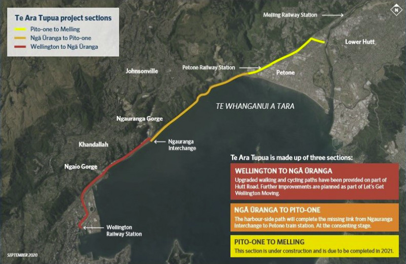
The funding is to build the Ngā Ūranga ki Pito-One section of Te Ara Tupua – a walking and cycling connection running from the Ngauranga Gorge to Petone.
Robyn Elston, Waka Kotahi National Manager System Design, says it creates a crucial active transport link between Wellington and Lower Hutt. The project’s design will also increase protection for the rail line and State Highway 2, strengthening Wellington’s strategic transport links.
“This funding decision means we can sign up to construction and get this important project underway”.
Robyn Elston says Waka Kotahi now has a high level of certainty over the project’s cost, which will be higher than the original estimates.
“The cycleway is technically complex to build, and like other large construction projects in New Zealand and around the world, it is affected by the inflationary pressures of a constrained labour market, supply chain disruptions, the increased cost of materials and the impacts of COVID-19. These factors are resulting in increased costs on all of our projects. For example, the price of diesel, a key input in construction projects, has almost doubled in the last year. Another key road construction material, bitumen, is at a ten-year high. Steel is also driven by similar international demand and shipping constraints, where the local price has risen by more than 30% over the past year.”
Back in 2019, the project was expected to cost about $94 million. This had doubled to $190 million last year, so the latest cost estimate represents a pretty significant increase. Given it appears most of the reason for the increase are due to labour and supply change issues, I do wonder how many of the other big transport projects around the country are faring – for example, we know there’s a cost increase on the way for the City Rail Link but the amount isn’t yet known.
I do have a few issues with the project/announcement. The biggest one is just a degree of jealousy this project is actually happening while in Auckland any walking and cycling access over the harbour, the closest equivalent to this project, has been repeatedly delayed and then cancelled. But there are two other things to highlight…
This is not (just) a “cycleway” project. . .
One day, someone should really do a thesis on whether shared paths (which allow for walking, wheelchairs, jogging, dog-walking, sightseeing and all kinds of personal mobility) are more likely to be called “cycleways” in press releases and media reports and headlines – does it correlate with budget, location, or both?
In this case, the community is clear about who and what the pathway is for:
Graeme Hall, chairperson of the Great Harbour Way/Te Aranui o Pōneke trust, said the new pathway would be a social, community asset.
”There will be prams, kids, dogs, bikes, all in the same social space, which we’ve never had before between Lower Hutt and Wellington,” he said.
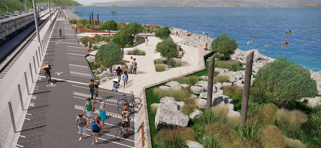
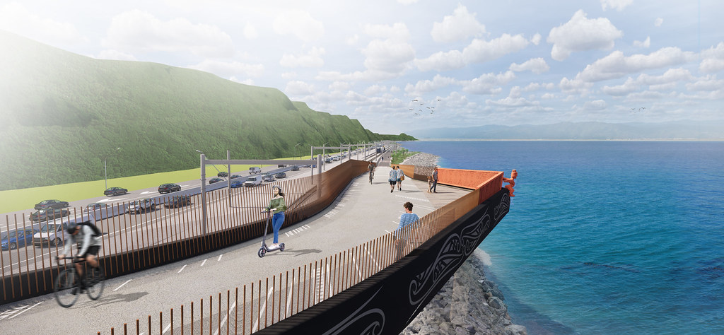
The project was also important for Wellington’s resilience – it will extend the seawall and protect the train lines from debris and seawater.
”People are probably thinking “that’s expensive for a strip of asphalt” but it’s more than that, it’s a huge amount of work to push out the seawall and create space so rail doesn’t get challenged on days like (Thursday),” Hall said.
In this case, one of the reasons this project is so important is it’s not just about building a “cycleway” or even a “shared path” – it’s also in large part about improving the resilience of the rail line and motorway it will run alongside.
In many ways the project is more of a sea wall first that just will happen to have a cycleway on top. “Strengthening Wellington’s strategic transport links,” as Waka Kotahi says – specifically by “better protecting the rail line from storm and sea surges, and future proofing for sea level rise”
This isn’t some theoretical issue either: there were 10m swells at the harbour entrance last week with 6m waves coming through into the harbour, with significant impacts to coastal communities, transport, and other infrastructure:
Thursday’s swells delivered regular waves of 6 to 7 metres in and around Te Whanganui-a-Tara – a 10m wave was also recorded.
Waves crashed over the coastal roads of Lower Hutt’s eastern bays, cutting off thousands of residents from their homes. Winds were so severe a Bluebridge ferry circled the harbour for several hours, unable to berth due to powerful winds.
And you may recall that part of the rail line was washed out during a winter storm in 2013.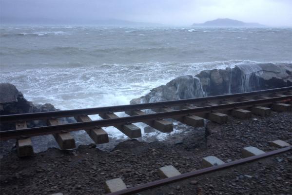

A decade ago, it took almost a week to get the rail line repaired, and while it was out of action, Wellingtons endured increased congestion and travel times. A study into the impact of that disruption found the economic impact was between $12 million and $43 million.
With climate change resulting in more frequent and intense storms as well as higher sea levels, it’s not hard to imagine that the 2013 event could be repeated on a fairly regular basis. And in Covid times, it’s also not hard to imagine the increasing challenges of funding the work and securing material and contractors to get it done in a timely fashion.
So, given how strategically important the project is for protecting the road and rail line, it’s surprising how little attention Waka Kotahi gave this aspect in their press release. It’s especially concerning as they know full well how some media love to use the idea of spending on “cycleways” to foment outrage.
Particularly when it comes to cycling, we really need our transport agencies communicating these broader benefits better.
. . . but it is eating up the cycleway budget
As noted above, the project is much more than just a cycleway, but my concern is that it’s eating up a huge chunk of the country’s earmarked funding for cycling and walking.
The current 2021-2024 National Land Transport Programme (NLTP) has budgeted for Waka Kotahi to spend about $371 million on walking and cycling projects across the country. There’s another $247 million in the budget for local authorities to spend. (Of course this is still pennies compared to state highway budgets and even local roads.)
That ringfenced NLTP budget for walking and cycling includes $195 million for this project, and that was from before this latest cost increase. It’s not clear where the extra funds to cover the cost increase will be coming from, but I worry it’s also coming from this general walking and cycling budget and achieved by delaying other important projects.
This is part of a concerning trend we’ve seen from Waka Kotahi in recent years, of pushing everything they can into other funding buckets. For example, in Auckland, the widening of SH20B for T2 lanes was initially planned to be paid for out of the state highway bucket but was switched to being out of the public transport one. The same thing happened with the Northern Busway extension. The change in those two projects alone sucked up all of the government’s increase in PT funding from a few years ago.
So we’ll have to wait to see where this extra funding is coming from for the Wellington project, but given how much of the work is about protecting the road and rail lines, I hope it’s not coming at the expense of other walking and cycling projects.
Another huge irony of all of this is that Wellingtonians (like Aucklanders) have been waiting the better part of a century for some basic connectivity – on foot and on wheels – that’s now finally being provided at huge expense, in a big hurry, and in large part in a way designed to protect a transport mode that makes it so urgent we finally see some action.
Looking at recent extreme weather events, some people might be moved to say: who’d want to walk or bike in that? When, if New Zealanders had had that basic option this whole time, we probably wouldn’t have to be asking that question. So looking ahead, the big question isn’t “how can we afford these resilience projects”, it’s how did we ever let ourselves think we couldn’t.

 Processing...
The reason Waka Kotahi is calling this a cycleway is obviously so that they can allocate funds from the cycling pot and they do not have to touch the pot which is for roads. That this then gets reported as “Cycle Path in Wellington costs an eye watering $311.9 million dollars” or “Cycle Path explodes in cost!” in the news is just gravy on top.
We are going to have to get good at these projects and build them fast. Perhaps we could pay for one of these for Kiribati as part of our foreign aid budget, 30km of this on Tarawa would go a long way to giving them a future.
This reminds me of that comic where a grumpy old git complains about climate change, “what if the whole thing’s a hoax and we made the world a better place for no reason?”
At least seawalls have a purpose. They are far better value than wasting money subsidising the middle class into their next new car in the vain hope that achieves something.
Well overdue project but you could have done just a cycleway for a lot less. It really is about protecting the highway and rail lines.
There were not 10m swells in the harbour last week. I’d be surprised if they were even 1 metre. The south coast is a very different marine environment to the Harbour.
Good catch, thanks Conor – we’ve updated the text to reflect that while a wave of 10m was measured at the entrance of the harbour, the swells coming into the harbour were (only) 6-7m.
Using the cycling and walking activity class for a project like this needs to be challenged at the highest levels.
There are many valid choices Waka Kotahi can make about the range of different projects to fund from each activity class, but the bottom line is that they have to achieve the strategic objectives of the GPS and the outcomes in the Transport Outcomes Framework. And to do so in a way that achieves them all.
This project is a good use of the State Highways Improvement activity class as it improves the State Highway. It is not a good use of the Cycling and Walking budget, because those funds are needed elsewhere to achieve the direction WK have been given.
When WK say there are funding pressures and more money would be required to reduce emissions, etc, they aren’t telling the full truth: better decisions on WK’s part would be encouraging modeshift and reducing emissions rapidly. The money is there. WK are simply making poor decisions about apportioning it from the various activity classes.
It’s strategic, it’s all about keeping pots of money available to build more roads. But it means WK are not meeting the legislative requirements, so the Government need to take action.
Agreed! Red flags should be going up when the per km costs of active modes exceed a certain level or drop below another.
When cycle lanes and footpaths cost the same as highway lanes, that cannot be good value unless you make some critical connection, like crossing the Waitemata.
If they are coming in at a suspiciously low cost, we should be eyeballing their quality. Nobody needs murder strips and rape alleys.
I guess this path makes a lot of sense and it is a shame that they still have to build it.
But who would like to take their prams next to a rail line and 4 lanes of busy highway?
These corridors make defenitely sense in terms of commuting but I feel like taking your kids for a walk or enjoying beautiful coast lines is a lot more enjoyable when there is not a massive transport corridor just along your way. And if I remember correctly, there are some opportunities in more pleasant environments in New Zealand.
Will there be footbridges (with accessible ramps!) to Newlands and Khandallah so that more people can use it efficiently?
Ok, just looked at google streetview. While the bridges are an excellent idea in 2d, the terrain does not really support it – but maybe they could make an effort? Without these bridges, the shared path ideas for bikes and prams become even less appealing…
(Funny though: When you look at street view, there are “Google Earth Outreach” streetview cyclists on the highway. So, why even build a cycle way?!? /s)
The busiest cycleway in the country (Tamaki Drive) is next to a four lane highway and a double tracked railway. Thousands of people also walk along the footpath there for recreation on nice days. Tamaki Drive is eve worse because the walking and cycling paths are next to the highway, while the Wellington one will be separated by the railway.
However, Tamaki Drive is in serious need of slowing and taming that traffic so that it is no longer a highway. It’s really not pleasant with only a kerb.
Heidi, I am specifically talking about the causeway section here. I have found that the construction of the cycleway has really helped traffic speeds on that section. Previously the road was very open, and it wasn’t uncommon to have someone fly past you while you were obeying the speed limit. Now that the traffic lanes are tighter, the average speed seems to have reduced and the differential between vehicles has also decreased.
From Ngapipi Road, right around to St Heliers really needs speed management though. Ideally achieving good compliance to a new 40 km/h limit throughout, with 30 km/h in the town centres.
Ta.
Curious to know why you think 40 km/hr is OK. The Vision Zero speed required is 30 km/hr. It will work – including for traffic flow – if the other elements are put in place, eg the vkt is reduced to the level that frees the buses from congestion so people can shift mode to this much safer mode and find it efficient, the toucan crossings are put in at the spacing actually required for the biking and walking networks to work, ambiguous spaces are removed and in particular, the flush medians are removed so that crossing distances are smaller, the road space is reallocated for a sustainable network, stacking lanes are removed, etc.
That’s the sector’s job now. I am always disappointed when I see people “compromise” by suggesting 40 km/hr is OK.
John B Goode, I’m not sure what are you talking about?
The foreshore along Wellington Harbour is lovely (except when a southerly storm is in force), and on a fine day it can be magic. For years it was possible to access parts of this foreshore on foot for recreation, fishing etc, until KiwiRail slapped a ban on crossing the railway and declared it off limits. The presence of the railway insulates the foreshore somewhat from the highway and outside of peak hours the trains are not too intense.
The cycleway when complete will be in 3 parts: Wellington-Ngauranga (partly existing now as a widened divided-path alongside the old Hutt Road), Ngauranga-Petone (the section along the foreshore), and Petone-Melling (currently under construction, squeezed between the railway and the SH2). The access to Newlands and Khandallah that you ask about is from the first section alongside the Old Hutt Rd which can be crossed to access Khandallah via Onslow Road (not a good route for cyclists for other reasons – far better via the Ngaio Gorge or the “Bridle Track” footpath), and at Ngauranga interchange to access Newlands/Johnsonville (via the Ngauranga Gorge cycleway – also in need of some love). The only place that will not be accessible to cyclists except via the highway is Horokiwi Road (mostly lifestyle blocks, a 370m climb to the top, attracting only cyclists who want to practise their hill-climbing skills).
The reason you see cyclists uploading images of themselves on the highway is that currently, this is the only official northbound cycle route – a narrow shoulder in places no more than 1m wide, separated from 100Km/h traffic by a white line. The existing so-called cycleway is only meant for southbound use and it doesn’t even exist for the first Km or so south from Petone. It can be used northbound but it is too narrow in places to easily pass a cyclist coming the other way, and it requires the 1km along the highway to be ridden against the traffic flow (actually safer than with the flow, because you can see what is coming at you).
“So, why even build a cycle way?”, you ask. Don’t pose such a silly question until you have tried riding the route as it is.
for reference Dave, the /s in Johns comment is a way of explicitly indicating sarcasm in text.
https://www.urbandictionary.com/define.php?term=%2FS
Existing Hutt Road cycle facilities:-
*Northbound*:
https://www.google.co.nz/maps/@-41.2357083,174.8330382,3a,75y,27.8h,93.94t/data=!3m6!1e1!3m4!1sAF1QipOD7JqoaJvzJ49bgplDlyGhUzsR8hYjZAsPc4jR!2e10!7i3840!8i1920?hl=en
*Southbound*:
https://www.google.co.nz/maps/@-41.2274149,174.8488118,3a,75y,235.82h,91.33t/data=!3m7!1e1!3m5!1sAF1QipMtzMa-wWN7YLFu0celQRsc7T0iyOA9EX0Km3kl!2e10!3e11!7i3840!8i1920?hl=en
Thanks Jack, sorry John. I didn’t see the “/s”.
Unfortunately there is so much cycleway-bashing going on down here that I’m a little over-sensitive to anything that looks like it.
Yiiiikes, do not use slang like /s on unsuspecting people, that’s just uncalled for
A driver killed a bloke on a bike there in early ’20 so show *some* respect
must hold back on the swearwords
WK now receives a lot of money from general taxes (gst, income tax, crown debt). O2NL, 1.5 billion, is getting funded from general govt budgets.
The other obvious example is the temporary reduction in fuel tax. WK is not cutting its spending, the money is being made up with general taxes. That’s another billion there.
The Wellington storm last week put logs and debris all over the road round to Eastbourne. The worst I have seen in many years. So they are building a necessary seawall to protect the road and railway with the added advantage of having a cycleway/walkway on it.
I suspect this is a double ,maybe even triple dead rat,that WK have had to swallow,1:active mode(cycleway,2:protecting the rail network,3:not adding any capacity to roading network.
They can take some solace ,that resilience on road is improved, and to shaft the “cycling” budget,while doing so, makes it all taste a bit better.
The money all comes out of the same pocket(ours),but you know,if you can play silly games with it,while it is being spent,must be fun for them.
How will it tie into the proposed Interisland ferry terminal. Maybe they are still working that out. What about a railway station for the terminal given the level of work being undertaken between the two projects. It would be cool hop of the Upper Hutt train and straight on the ferry.
Already been suggested Royce. Response was to the effect that this is ‘out of scope’. Looks like we will get a nice new ferry terminal but with access no better than now. Silo-mentality unfortunately.
Kiwirail turned down the opportunity to ease curves/increase speed from this project. They don’t seem interested in speed increases anywhere, just 80 km/h freight trains.
Actually KiwiRail wanted to straighten out the railway line as part of the project but NZTA wouldn’t agree the additional cost
Julie Ann Genter has spoken loudly on NZTA using cycling / walking budget for motorway seawall protection projects. So Heidi, its been raised at the highest levels, but it seems still not high enough.
As a cycle and walking asset – given its price – its BCR must be very low. Its cost per kilometer, must be through the roof. Two very good reasons to not fund an active transport asset – as these funds could be used way better elsewhere (anywhere). Is that not the reason for BCR metrics?
As it seems a seawall needs constructing – and will regardless, perhaps its better to add a path on top at a later date, for cents in the dollar.
I note Brian Roche is setting up the 3 waters reforms (needed), Im hoping that the same misalignment of funding and outcomes is not being baked into this huge infrastructure program.
replying a couple of years later.
Seems Sir Brian Roche’s work has been scuppered. Sorry Brian.
And now this cycling project is up at $311.9M
Any reporters out there – Walking and Cycling budget has been halved and our new GPS requires any walking and cycling components to come from this activity class. Seems we have a single project draining all funds for any project of note. Convenient way to kill multiple cycling infrastructure projects everwhere.
Im struggling to reconcile the picture of a derrek/offshore rig thing coming from the cycling budget – its laying an artificial reef as part of walking and cycling !!!
https://www.facebook.com/nztawgtn/posts/pfbid0M3MEsGcRdG1pJ3ZxtJvzjkCQMSTotpGHMLjZLxpqinUfgUr3zMLG9QaLHSY3fiw4l
I have a cunning plan to cut the labour and fuel costs of this project that would make Blackadder proud. Unfortunately it is more than a little evil in that I suggest we reintroduce the punishment of hard-labour to our prison system and make more use of unpowered transport for the final positioning of the rocks used to create the seawall. I’m thinking here of copying the system used to create the seawalls and roads around the Otago Peninsular built by the Pakakohi and Parihaka prisoners during the 1870s. Obviously that was utterly evil and directly racist as is to be expected from our very unpleasant colonising ancestors. But it got the job done and if we did it now it would be slightly less evil because the prisoners probably actually committed crimes and we can we pretend we are better people because it will only be institutionally racist rather than deliberately so.
Sorry, still racist because around half the prison population identifies as Maori.
Why not make the highway a toll road only payable by labour on the seawall? You can sell excess credits on the open market.
Redistributive, if not progressive.
RMA lawyer here – working in the Wellington region.
There is an existing cycleway, on eastern side of the highway ie western side of the railway line, that could easily be upgraded.
The Ara Tupua cycleway at 5m wide will be pretty quickly swamped with users and look out for conflict between 40km hr commuters and dog walkers.
But Waka Kotahi get cyclists out of their road corridor.
That said, it will be nice to ride, except on any day exposed to a decent southerly wind and waves ….
Same deal is rolling out on the other side of Wellington harbour in Eastbourne. A cycleway which is not nearly wide enough but allows Eastbourne harbour seawalls to be upgraded.
> There is an existing cycleway, on eastern side of the highway ie western side of the railway line, that could easily be upgraded.
Jeepers, that’s too narrow even for one way riding, neglected, full of grass, bouncy, and missing a km on one end.
You’re BSing and you know it.
Once I thought I’ll have a quiet time on the path, then lifted the bike over the barrier to ride the highway shoulder b/c the thing was too bouncy.
Eff the f off.
glass not grass. same difference
I think you’ve misunderstood Tom.
Tom has not misunderstood – he actually rides the existing (inadequate) cycle-path alongside the Hutt Road every day, twice a day (brave man!!), so he is probably the only person here who is actually qualified and experienced in the actual factual….
But NZTA should be honest. Probably three quarters of the cost here is down to the need to provide stability to the seawall on the existing rail line, and a relatively small amount is needed for the small cycleway that runs along the top of this seawall. They’re spinning this like a top.
Of more concern to me is : where is the considerable amount of rock for the seawall going to come from? Hundreds of millions of tonnes of rock is required, and Wellington’s quarries are getting sparse. Plus, enormous amounts of truck movements likely to be needed up and down the existing SH2 to get rock to site. This is a monster project in the making.
> easily be upgraded
Nothing to be misunderstood about this claim.
The claim is wrong.
Nemo, the rock was originally planned to come from the construction of the Petone-Grenada motorway. Two birds with one stone, and this helped to greenwash the motorway. It looks like that won’t be happening any time soon, so the rock for the seawall will have to come from elsewhere. The amount will be trivial compared to other reclamation schemes. A few million tonnes perhaps, certainly not “hundreds of millions”.
Older readers might remember that there was a popular shared path for cyclists and walkers between Petone and Ngaraunga in the 1960s.
It was between the railway line and the road and was (I think) taken for road widening about 1970.
This is yet another example of cycling facilities being taken away for roading and only belatedly replaced!
Huh. Wow. Ta.
I look forward to totally un-snarky press releases from astroturf groups, commending the procurement of a sea wall to protect the railway and the road.
greater auckland lol
Had a bit a google map and street view look around here and can see the dodgy existing pathways and painted on road cycleways there. This is a great upgrade (& not just the cycleway aspect).
Congrats to Wellington planners with the cycle/walking path on the SEAWARD side of the motorway. Not possible in Auckland with the oddly named “SeaPath”. In fact we get a cramped landside path, squeezing between cliffs and cars, the sea somewhere past eight lanes of traffic, with multiple motorway and ramp intersection crossings, then an exit point as far as the planners could get from Takapuna and the route to Devonport. *sigh*