Auckland Council have launched their pre-consultation consultation for the changes to the Auckland Unitary Plan in response to the governments housing rules under the National Policy Statement on Urban Development (NPS-UD) from 2020 and the Medium Density Residential Standards (MDRS) from 2021.
We’ve talked about the NPS-UD and MDRS a number of times and together they represent a significant and positive change in housing policy by the government by requiring councils to allow for more, and more intensive housing in our biggest cities. Helpfully they also have cross-party support meaning they should endure changes of government.
As a quick reminder summary of the two rules:
- The NPS-UD requires councils allow for at least up to six-storey buildings within walkable distances of the city centre, metropolitan centres, and rapid transit stops.
- The MDRS requires councils allow for up to three homes of up to three storeys on most residential sites.
In both cases there are some exceptions allowed, but not many.
This preliminary consultation is fairly short at just under 3 weeks and is being used by the Council to inform the changes that will be formally notified in mid-August. For the council, it is a useful exercise in order to iron out any glaring issues with the proposed changes. But my major concern about it is that Councillors and planners used the same process back during the original Unitary Plan debate to water down the plan and it was only the Independent Hearings Panel (IHP) that fixed large parts of it.
However, given the government rules behind this change there are unlikely to be as many avenues for council to water the changes down.
I think the good news is that many of the proposed changes would bring the Unitary Plan in line with what it probably should have been when it was first adopted in 2016. They will make it much easier to build more housing in the existing urban areas, especially around town centres and rapid transit stations.
For those familiar with the existing Unitary Plan, the council have used the same colour schemes with the MDRS changes being shown as tan-coloured Mixed Housing Urban Zone, and the NPS-UD rules being merged with the orange Terraced House and Apartment Building zone – both are highlighted in the red box below.
It’s easier to look at the maps directly through the council’s viewer, but you can see just how much they’ve changed with these two images.
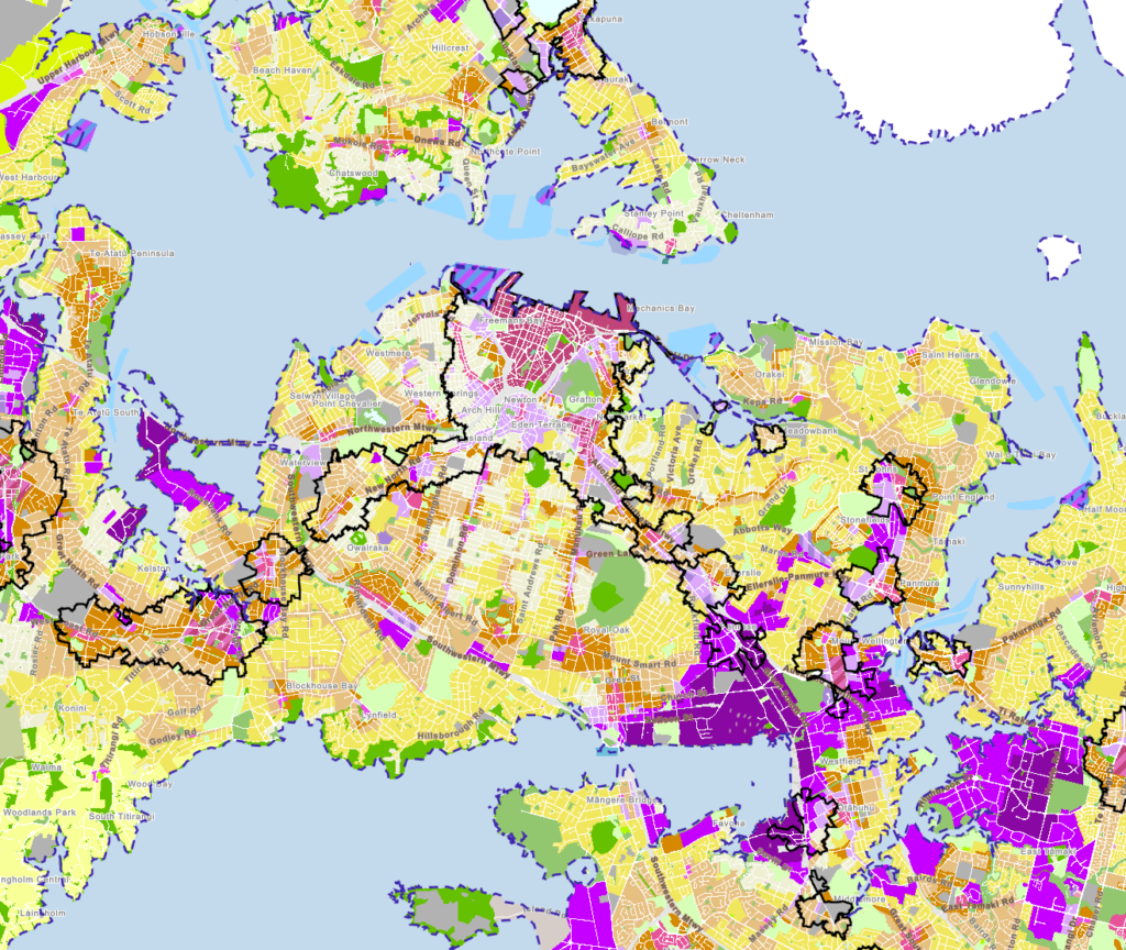
Zoning of the current Auckland Unitary Plan
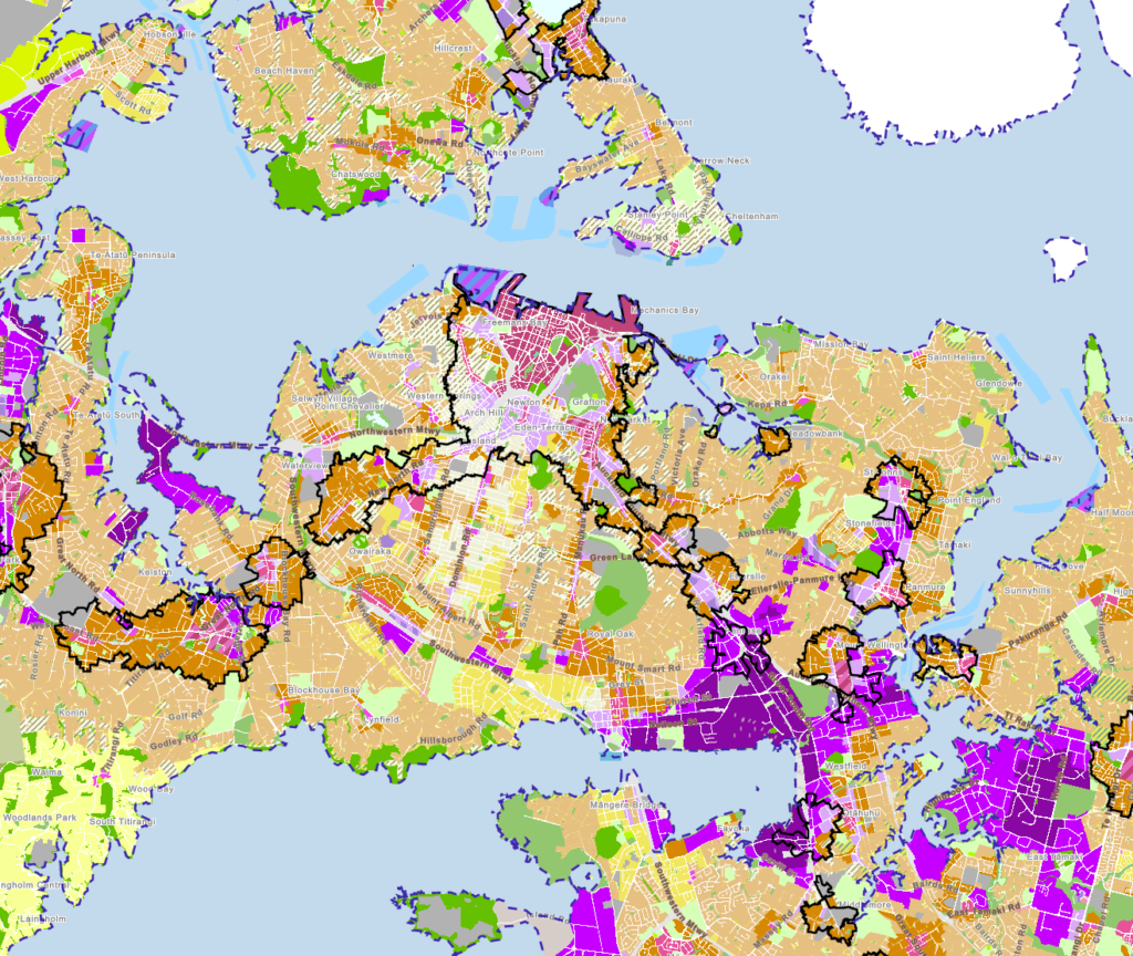
Zoning with the proposed changes
The not-so-good news is it doesn’t feel like the Council are following the spirit of the rules. It appears the council planners have spent most of their time since these changes were announced trying to find ways to avoid change to many of the high-amenity and well connected areas near the city centre, which has left almost no time to actually plan how to make the city better.
In a briefing yesterday this perhaps summed by best by two comments from the council’s planning manager.
- “We’re all about special character”
- “We didn’t have time to investigate further”
Now to explain those in more detail.
Special Character
The biggest unknown was how the council would deal with the “special character” areas they created in the Unitary Plan. These are largely the swathes of old villas chosen for protection based primarily on a view of aesthetic appeal – as opposed to being actual heritage protected buildings. As the council describe it:
Special character is where councils choose to use planning rules to help maintain a sense of history and place for whole groups of properties within older residential suburbs by limiting building heights and density, and in many places, requiring a resource consent to demolish existing character buildings.
These rules aim to retain and manage the ‘character qualities’, or the look and feel, where areas collectively share similar and consistent characteristics, such as shared streetscapes, trees, street patterns, building types and architectural styles.
The council have spent considerable time and resource performing individual assessments of the approximately 21,000 homes that had special character, on six different criteria. As a result of that, under the proposed changes that around 4000-5000 dwellings will no longer get that special character protection. These areas are shown on the map below – with the red areas proposed to lose special character protection, and the blue areas retaining it.


Where I stand on "special character" housing zones, with this artists impression of the Council meeting we had on it recently pic.twitter.com/9AbLVOeRXf
— Cr Shane Henderson (@HendoWest) April 19, 2022
Scoot has put together a good thread of some of the places losing special character protection, which highlights just how poorly it was implemented:
Let's us take a look at the places which are losing special character.
In this map, it's the bits marked in red (blue is being retained) – but let's dig deeper and see what's being lost. https://t.co/dZG8RgOFzw pic.twitter.com/4OFKjJ5gjc
— scoot! (@ScootFoundation) April 19, 2022
While Matt Prasad has some examples of where Special Character protection is being retained:
AKL Council is proposing a "two-storey – single dwelling residential zone" for this site in Devonport and retain its special character overlay. Needless to say there are issues. pic.twitter.com/OZTqzrNDBJ
— Matt Prasad (@matty_prasad) April 19, 2022
The council should have used the rules as an opportunity to make significant changes, either removing this protection completely or at least having the vast majority of it removed.
Not Enough Time
As mentioned earlier, one of the requirements of the NPS-UD was to require zoning of at least six storeys close to rapid transit stops. That’s great, but if we really want to make these places liveable and reduce the need for travel – a key tool in reducing emissions – it’s also important that people have access to local shops and hospitality, etc. As an example, so residents can perhaps grab a cup of coffee before their morning commute, or pick up a bottle of milk or some food on the way home.
While many of our train stations are located in town centres which can support this, many are not. And so perhaps Mixed Use zoning which would help allow for this would have been appropriate in at least close vicinity to stations.
An example of this is the Ranui and Sturges Rd train stations where there is potential for a lot of housing, but without much (or anything) in the way of amenities and services supporting those residents to live and shop locally.

Yet when asked why this wasn’t done, council response is that they would like to but they simply “didn’t have enough time” to consider it.
So to be clear: the council had time to individually assess thousands of properties for special character protection – but not enough time to make the areas that will have to pick up the housing slack more liveable for the people who will be living there.
Other Issues
One of the most obvious issues with this proposal can be seen right in the centre of the isthmus, where no change is planned due to the light rail project. Essentially the council planners are just leaving this for light rail to deal with, which seems like a poor outcome, especially if light rail doesn’t end up happening.
A better idea would be to make the changes now, in line with the government policies, and make additional changes to support light rail when that project has been finalised more.

There’s also the issue that on the Eastern Busway there’s no supporting zoning around Edgewater and Burswood. Fixing this omission is important, as the NPS-UD includes in its definition that proposed rapid transit stops be included.
What the hell, Future AMETI stops along Ti Rakau Dr haven't been included in the proposed changes. This route is known and has very little variation. pic.twitter.com/xkPHg0SvTl
— Matt Prasad (@matty_prasad) April 19, 2022
Speaking of rapid transit, the definition for this is actually quite broad:
rapid transit service means any existing or planned frequent, quick, reliable and high-capacity public transport service that operates on a permanent route (road or rail) that is largely separated from other traffic
Based on that, the council should have also included many of the frequent bus service routes on the Isthmus – something I recall Phil Twyford, then Minister of Urban Development and the minister behind the NPS-UD, confirming at the time.
There is plenty more we will have to say about this Unitary Plan 2.0 in future posts.
Consultation is open till 9 May.

 Processing...
I think the govt really butchered the definition of rapid transit by not having a specific criteria, surely any major arterial in Auckland with a combined frequency of bus services every 5 minutes during peak hours should count
I agree, as it would have given people a realistic idea of what to expect in terms of services along those corridors (e.g. yes, you’ll have apartments but you’ll also have light rail on your doorstep).
But that would require governments to fund and build rapid transit to a meaningful standard and at this point, there’s no indication they are willing to do so, or even capable of it.
You mean like Goff climate change bus plan that intends to have 90% of Aucklands urban area with 500 meters of a frequent transport line? Yea, you would hope so.
Can the council’s planning manager be removed/fired or is he an untouchable, unelected employee who seemingly imposes his own views instead of the law.
Wholeheartedly agree. They’ve had two years to get NPS-UD rules out and yet “the “revised THAB Zone provisions are not currently available for feedback”. A total failure in whatever process they’ve adopted! (I present a better one in the comments below.)
The process is stall as long as possible and hope for a new government.
The “…quick, reliable…” part of the definition would probably require good (or maybe better than just good, ask a lawyer?) priority for buses as well as high frequency/capacity service.
Bus if so, then why not? Why shouldn’t a quick and reliable bus every 5 minutes not meet the criteria?
We got caught by this crap in Wellington. Like the neighbours, we made the mistake of renovating the front of a rental villa and because they looked ‘cute’ the planners stopped the six storey zone just down the street. This is not about heritage, it is about twee.
I don’t even think it has to look cute. I’ve just left a cold, damp Villa in Grey Lynn that hasn’t been done up in years. Its split into 3 x1 bed units, has no redeeming feautures or architectual fixings, its simply a bland wooden box which is still being protected. It’s BAU until the Government forces them…the same Government fast tracking massive satelite Towns out in Drury. Auckland has no hope..
Are AC trying to provoke central government here? This entire thing is still ridiculous. West, East and south Auckland are pretty much all terrace and apartment zoned, but the houses between Sandringham and Dominion are not? How does that work with almost absurd investment with ALR?
Some sort of reverse prejudice here? The North Shore is also predominantly terrace and apartment zoned. Why exclude them?
I’m going to get crucified here for going against the majority but I feel this whole government interference is unnecessary. The UP allowed for plenty of intensification. Enough for Akl’s predicted growth for decades to come. The issue that needs to be addressed is the quality of the build not just the location.
This government has shown they are clueless with the proposal (fortunately U turned) to extend the urban boundary. Developers could already be building apartment blocks all over the place. Instead we get shit box terrace developments.
We need legislation that encourages developments in the inner city not the rural fringes. This does nothing to address that issue. ironically there are places that are zoned for up to 6 stories under the UP that have had that reduced to 3.
What really does this achieve? Apart from Wellington bureaucrats sticking their oars in? You could argue that reducing the area where intensification is allowed would force developments to go where it is most practicable. Around transport nodes and town centres, not Flat Bush and Whenuapai where almost everyone will be forced to commute by car.
The 1 line summary is basically this:
The area where intensification is most practicable largely overlaps with the area that still has a blanket heritage overlay.
The key thing about successful high density is that you can’t have people rely on cars for most of their daily life. The most obvious places where this is possible are the areas right next to the city centre.
The entire reason central government got involved, was that building apartments in Kumeu when you are unable to do so in Ponsonby, is ridiculous. Auckland council now interpreting this intervention as more less keeping the status quo, is beyond a joke.
+1
except their masterplan was to encourage more greenfield development. I don’t think the Council are the good guys but there are already plenty of options to intensify within a few km’s of the CBD that are being ignored. Yes there should be more but what does this plan achieve in terms of making it happen?
DM. Look at the map. The place nearest the CBD is where the development should have happened first, AC is still trying to prevent that from happening.
Walking distance from the city centre is the best place by far to have intensive housing. AC want to keep it illegal to build the same level as development as Places like Kumeu, this is madness.
I’m not sure of the specifics but I figured this must have something to do with the process of value capture for the ALR?
I live in one of those “blue” areas. 5 minutes walk to New North Rd bus services, 10 minutes to either Mt Eden or Kingsland rail stations. Sandwiched the rail and the motorway, there is nothing of any real heritage value in my street. It was subdivided as working class housing in 1905. There are basic villas, 1 bungalow, several new dwellings, and a collection of what could be called “cottages”. Nobody drives around here for the pleasant housing typology! All the heritage overlay does for us is to make it more expensive to do any work on the dwellings as Land Use Consent is required.
Don’t forget that council got themselves into this predicament by providing the special character overlays in the first place. They’re not actually about protecting heritage or any of that sort of thing, they protect the property values of a vocal minority. Council didn’t want to put on its big boy pants and instead rolled over so wealthy architects and lawyers in St Mary’s bay could keep living in renovated sheds.
Sorry, you’ve got this completely wrong. This new zoning will double the land value of my existing heritage bungalow because up to six storey developments can now be undertaken. I’ve compared recent sales for development sites down the road, before the new zoning was announced, with the current valuation for my home. I’m imagining that being able to put six storeys rather than the current three will actually inflate the value further. So the rezoning is not reducing the value of existing owners, it is massively inflating it. I’m not interested in selling, but I’m sure my children will thank you all for the gift.
Thats generally not how that works. It’s a market, increasing the supply of opportunities to build over most of the city* lowers the value of each build opportunity.
You would be correct if they only upzoned your street and kept the rest of the city as-is, but thats not the situation.
*actually country, hopefully lowering Auckland’s need to carry such a large chunk of the population growth.
Even if it does still raise the value of your land (which in some situations, it still could), doubling the land value, and over doubling the floor area allowed (which is probably what is the case) would still lower per dwelling land costs.
As a thought experiment, you could extend your argument that upzoning makes housing more expensive to the extreme. To lower housing costs we should ban any home building through ultra restrictive zoning, no land will ever be more useful than it is now. Do you think that would lower the value of homes over time?
If you are genuinely interested in reading detailed reports on how to alleviate house prices and what has caused them to be so high now, then there was a recent report from the infrastructure commission:
https://www.tewaihanga.govt.nz/strategy/reports/te-waihanga-research-insights-march-2022/
So some of that proposed THAB zone is over a kilometre away from any town centre. What could possibly go wrong? Maybe this zone is not a smart idea to begin with and it should just be mixed use.
I thought THAB is a bit mixed use. Bottom floor can be shops and businesses. Obviously not as good as the the real deal mixed use but its something at least
The existing THAB zone is a nonsense. The existing rules make some sense for terraced house – if wasting land is what Council wants – but they make NO sense whatsoever for a six storey building. Council needs to open the rule making process up to public scrutiny so another unworkable mess isn’t the result. (See my post below for a possible approach.)
Looks like my place has gone from single house zone to 2 story single dwelling zone.
What does this mean?
I know most single house zones require no less then 600m2 for a single house, will this be reduced in the new zoning?
Interesting…. As far as I’m aware, the Government changed the rules so that ALL of the properties in ALL of the Tier One cities (which includes Auckland) are allowed to have up to three buildings, each building being up to three storeys, as of right. Blanket pre-approval rights, no need to ask. Areas along “Rapid Transit” routes (which would seem to indicate train routes to me, not bus routes except for NEX) are meant to be gradually infilled with housing at six storeys high (minimum?).
So the “Special Character” Areas then have a right to keep their low height 1-2 storey existing villas and bungalows if they want – and does it mean that you cannot build taller there, or is it that you can build taller, but just need to ask (eg Resource Consent)? I’m a bit confused by all that.
And lastly – is the Special Character seen as a good thing by owners, or an imposition eg that they cannot make use of the extra value in the property? Are people protesting For it, or Against it?
I think the government did allow some heritage provision in the three building rule? Otherwise what is the point in AC bothering with heritage if you have the right to bowl the old place and build 3 new ones?
Character zones aside, this continues and expands a big change to the underlying structure of existing suburbs and I don’t believe this type of density can simply be shoehorned in without some measures to manage that density and provide adequate amenities. Council do need to go through this with a fine toothed comb and prose solutions to issues such as:
-How to ensure sufficient number of decent healthy trees(new and existing) are provided in the face of intensified, lot-by-lot infill development. Where does this land come from?
-What increased public outdoor space will be provided in response to the increased population density and reduced private outdoor space. Where does this land come from?
-How to allow for new /improved connections through a neighbourhood when walking/riding to amenities/public transport is more widespread – for example how to connect up the ends of cul-de-sacs to allow good through-access for active modes? Where does this land come from?
“ I don’t believe this type of density can simply be shoehorned in without some measures to manage that density and provide adequate amenities. “
The ship has already sailed for most of the city, this happened years ago. The only place that is really getting this character protection is the central suburbs. You know the ones closest to employment opportunities, recreation assets and (by far)the best transport access.
It is ridiculous to say Henderson and Manukau should be higher density than Kingsland and Ponsonby.
This does show up the real problem – blanket Zone rules do not really control the form of development. Framework planning at a neighbourhood level (as is done for greenfield development) is needed if decent homes and decent neighbourhoods are to develop, with the density that supports local servicing and local living, as well as transport accessibility. Sausage mansions (5 detached 2-3 storey houses with a driveway and no green space) are not the housing that delivers on this.
The problem is that the Council’s “fine tooth comb” isn’t being usefully applied, because – broadly speaking – the problems we have stem from regulations that keep the density lower rather than from regulations that allow higher density. This is a fact the Council planning management don’t seem willing to accept.
It’s the low density zoning that means we’ve created a car dependent city, a dangerous city to walk and cycle, and an unsustainable city. It’s the low density zoning that means we have built way too much infrastructure per capita to affordably maintain. It’s the low density zoning that means we’ve sprawled onto quality agricultural soils and onto areas that should have been left for the biodiversity.
None of this is the result of intensification, it’s a result of the “underlying structure of existing suburbs”. In terms of trying to house our population decently and to create a more sustainable city, intensification is a straightforward and time-honoured solution.
So while I completely agree that trees, connections, public outdoor space are important, and there are more things I’d add to the list – eg Council should be working to reduce overall parking supply and to reduce the number and width of vehicle crossings – their car dependent and property rights focused mindsets are preventing them from seeing that work as their priority.
At this stage of the housing, transport equity and climate crisis, there should have been no time for concentrating on “special character” but on the important issues required to create a sustainable future.
> What increased public outdoor space will be provided in response to the increased population density and reduced private outdoor space. Where does this land come from?
Around me on the central isthmus all the small local parks are dead. Hardly anyone uses them, just the odd person taking a shortcut. We could do with some more density on the Isthmus to liven up the outdoor spaces.
If memory serves me correctly, every developer pays the Council “development contributions” that are supposed to fund many of things you mention. I suspect though, that they are being used to pay for the Council’s new train set that benefits a tiny fraction of Auckland’s population.
Reading through the Pre-Consultation information its hard to believe that the Council is saying that it has run out of time!I do think that the consultation time should be extended for proper debate. It really is not long or good enough. If we can get people to the moon and possibly Mars … why can’t we plan Auckland properly and thoroughly. What we decide now will be there for the next 100 yrs or so. Life built around the car or an adequate public transport system. As long as medium and high density zones are well designed full of individual character reflective of the residential neighbourhood and local environment …what can possibly go wrong? ….. (fill in the blanks) …
Yes more time needed it seems. Looks like slight density upgrade in my area.
See my post below – I too am staggered that after two years “the revised THAB Zone provisions are not currently available for feedback” (Source: Information Sheet #3″ (THAB Zone). A MASSIVE process failure. But one I have proposed a solution too.
I’m trying to fathom why any of you care that more intensification could’ve been done? The Unitary Plan already allowed for intensification to cover growth for decades, now this plan takes that even further, so what more do you want? There will be a very small number of people breathing a sigh of relief that their area is exempt. Why would you want to rain on their parade? Just let it go. Read a book or go for a walk for goodness sake.
Couldn’t be more of a comfortable boomer/home owner reckon than if Orsman himself had written it
Which one is true?
1/ the Unitary Plan already allowed for intensification to cover growth
2/ the Unitary Plan needs to include “future urban areas” and other sprawl to accommodate growth.
“what more do you want?” Intensification in the right places.
Things are not as you suggest. We are still wasting land and we are still driving people to own cars to get anywhere. I suggest you read the THAB zoning rules. That bit of absolute nonsense explains why the bulk of the THAB zones have only low-density THs being built in them.
Looks like the planner went on holiday and when the boss asked to see the revision he just made everything the same too save time.
Council have made the whole ‘planning’ exercise so complex and bogged down in minutiae (and outright nonsense) that Council planners have been leaving in droves to the private sector to earn the big bucks developers are willing to pay to wade through the mire. So your assertion that there might be only one planner on some parts of the exercise might well be correct. 😉
For multiple decades across many administrations the high level Council strategy for our city’s urban form has been to create and maintain a ‘Quality Compact City’. This is well supported by all evidence as best supporting wellbeing and prosperity, ie makes for happier citizens and is more financially efficient (CHEAPER) to provide the necessary public infrastructure and services across a small urban footprint. So far, all good.
Also for this time Council planners have interpreted ‘quality’ to pretty much only mean preserving specific twee (thanks Miffy) Victorian and Edwardian residential areas, and ‘compact’ to be impossible/unimportant (sprawl instead to house growth locked out of existing city). The later is a function of the former, hence ‘impossible’.
This contradiction was more manageable when the sprawl areas were closer in, were coordinated with govt funded m’way building, but like all sprawl and car-only urban growth the problems accelerate as distances and volumes increase, though at the start it’s not too bad, even feels great, as the first new burbs are still in the countryside. But over time productivity declines, access declines, public amenity declines, nature is pushed further and further away, public costs ballon, pollution, harms, etc all accelerate. Traffic congestion; a known structural outcome of this model and well understood inefficiency and wellbeing cost, becomes permanent.
So it is, and here we are.
Time to review council planning dept, realign it with the QCC strategy, to reduce this very specific aesthetic obsession it’s proper heritage level, and not allow it to undermine the wellbeing and performance of our nations largest city. There’s too much at stake.
hear! hear! … I said the same thing to my Councilor.
The fact that “the revised THAB Zone provisions are not currently available for feedback” after TWO YEARS and yet we’re supposed to provide feedback on them is a FAILURE of the highest order! The THAB zone is a nonsense by the way and should be split.
Yup.
What would have been nice is a CE of Council or a Mayor who cared enough to match the staff output to the tasks they were given. Who cared enough to check if the Auckland Development Strategy was compatible with the climate and liveability aims of the Council. But we didn’t.
I see a lot of issues arising out of six level residential in traditional industrial areas such as Penrose and Mt Wellington. The walkable catchment will put high density residential hard up against established industry (and in some cases heavy industry) which is vital for employment and general economic output. Examples include a concrete plant sitting amongst the proposed 6 level zoning in what is an industrial zoning. With existing use rights this plant will remain where it is for the very long term. It will be interesting to see how this is dealt with during the consultation phase. I would imagine that the central governments vision will be considerably watered down when the reality of the outcomes are looked at in detail.
All the unitary plan is tell you where the councillors and their “managers” live. Notice there’s never intensification in the expensive suburbs? It’s always the medium and lower priced burbs. I have a section about 4 doors down and across from me on a semi arterial route, opposite a side street. It used to have an average three bedroom home on it. Now it’s planned for 22 2 bedroom units. The ground floor is parking, albeit 8 spaces. So if a young married couple buys them thats 22 – 66 cars for 8 spaces. Because they will all have at least one car, some have 2 and their flatmate has 1 that how i got the numbers. So where do they all go? On the road. But it “council land” that magical place the whole of Auckland council including their 2 exceedingly useless “council controlled” organisations AT & Water(un)care live in. Meanwhile us the poor long suffering plebs live in the real world. This “complex” is also on a stretch of road which is earmarked to lose it’s parking. Because in “council land” everyone walks or cycles. On the topic of walking 600m from me we have a small shopping centre with a countdown, I have astreet full of pensioner flats opposite my driveway. Alot of them are of reduced mobility and there is a section of footpath missing about 200m from their complex. Watercare dug it up and left it. AT put gravel down but havent concreted it yet. Its a large area according to AT ( 5 meters long). Watercare dug it up the first week of january. It’s mid april. I regularly see old people and mothers get stuck in the gravel. Walkers,wheelchairs,prams and walking sticks dont go well with gravel. But its always someone else’ s problem. But they have to have a manager to do something. A something which will be decided upon after a year of meetings, overseas junkets, iwi consults etc instead of just sending two council workers to concrete it it would be in a couple of hours if that. But does AT or the councillors walk or cycle?
[The remainder of the comment has been deleted for violating user guidelines.]
Apologizes for the punctuation and so forth, brain moves faster than ha d
Information Sheet #3 (THAB) says: “The revised THAB Zone provisions are not currently available for feedback.” …. ??? …. WTF?
How are we supposed to provide feedback?
And yet … The wording suggests they’re going to tweak a seriously illogical existing zone (the THAB zone) that implements rules for ‘houses’ and ‘apartment buildings’ that are semi-sensible for houses but a total nonsense if you want high density housing through apartment buildings.
When are the planners going to realise the rules for houses DO NOT work when a building is tall?
Further – the *process* by which they ‘figure out’ the rules for a six-storey building or indeed a block of such buildings, remains extremely secretive (and therefore un-democratic!). I suspect intentionally so, so that they can, as they have done with the existing THAB rules, stymie the development of tall buildings with far higher densities.
It is time for the process to made public, open and thoroughly worked through so that each ‘building control’ can be thoroughly understood in the context, not of a single site with a single building form and a single sun angle, but with multiple applications over sites of various sizes, with various compass orientations, with various forms (both good and bad), and with a full hourly based sunlight and shading analysis. Additional goals should be added like ‘no less than 750m from a small supermarket’. I would expect – as a minimum! …
1 – three different site sizes, say 500, 750 and 1000+ sqms
2 – at least three site positions, say mid-block, corner, road both sides or road one side with open space the other
3 – at least three different site shapes, say long and short rectangular, and squarish
4 – at least four different compass aspects, say north/south, east/west, nor’east, sou’east
That would give them, and us!, some 108 (3x3x3x4) model sites upon which concepts like shading and sunlight access and privacy can be objectively measured.
I’ve actually done this with some 20 different sites and believe me – the *existing* THAB zone rules result in some laughably BAD environmental outcomes on about half of them. And some of these sites are simply crying out for ZERO side yards to maximise dwellable space! And the rule “go big” at the street edge results in awfully dark and shaded streetscapes in many instances.
Of course, Council will cry “too expensive”. Quite frankly – this is b.s. Without such models being available and subject to public scrutiny, Council is driving the cost onto the developer to explain and justify why their archaic rules don’t work.
Further, Council retains its existing nefarious mechanisms to stymie the development of high density dwellings while ensuring land is wasted to lower density ‘terraced houses’.
Council has had TWO YEARs to get the NPS-UD rules together – far longer than re-zoning for the MDRS. With this amount of time but with the “revised THAB Zone provisions” “not currently available for feedback” it appears Council has NO objective process in place to evaluate ANY rules as they relate to six-story buildings. I.e. this is a massive failure of process!
I have presented a process that will work. Will be democratic. And will result in good outcomes – both environmental and from a cost-benefit perspective. Council should adopt it. Or provide exceptionally good reasons for why their failing process is better.
Clearly, there’s a lot of pressure to fix THAB so it works well to create perimeter block housing in an organic, site by site way.
Including their thoughts boldly now, on this point, even if they’re not sure of exactly what to propose, would have been the most important progressive move in this whole pre consultation consultation.
(See my post below where I mention perimeter blocks.)
Perimeter blocks can work exceptional well for many blocks that orientate well to the sun’s arch. For example, a block that runs largely east to west and is sufficiently wide, the shading effects from the sides in the morning and evening can be eliminated while the summer sun from the north is maximised into the inner courtyard (the width thing). But they’re not the answer for all blocks.
The new ‘rules’ MUST ALLOW for them. Why?
Land in our city is our most prized resource. Having a 2m strip between 20m long buildings wastes 40 sqm of land. And a massive 240sqm over six storeys! Even if it’s not used for dwellings, an extra 40sqm in the garden area is always going to be welcome. (Closing these gaps also eliminates the wind tunnels that can cause gusts strong enough to knock over old people and cyclists!)
But will the new rules allow for them?
Sadly, Information Sheet #3 (THAB) says: “Outcome 3: Manage Dominance and Shading Effects on the Street. We are, retaining … the side yard setback of 1m in the THAB zone.”
This is more nonsense. Anyone who has walked some of the streets in London where there are NO side yards between buildings or the wider boulevards of Paris would stare in disbelief at anyone making such a statement and they’d laugh out loud if the reason given was to “Manage Dominance and Shading Effects on the Street”.
I’ve addressed the Shading nonsense in other posts so I’ll leave that one alone. But the Dominance reason is equally frail, if not more b.s. Side yards have little effect on dominance but front yards do! Why is that? Mainly because people don’t spend much time looking up thus, so-long as there is good sunlight in the street and attractive design and planting in the front yards then that is more than enough to address dominance.
So many of Councils statements on Apartment Buildings have become biblical in proportion in that we’re supposed to accept them as unquestionable gospel. We must NOT let them get away with such nonsense. We must start questioning EVERY assertion.
Good God they are hopelessly lost!
You really have to question their competence when Image 1 in Information Sheet #3 on THAB can’t even get the *existing rules* right!
It is WRONG in many ways.
1. The first 20m allows for a greater bulk, NOT the first 21.5m.
2. The recession plane after those 20m is 60° and NOT 45°.
3. The 60° recession plane after 20m starts at 8m high and NOT 3m.
… On the plus side – the maximum permitted bulk outline in the image is better than the words!
Who put this misinformation together? And worse – Who Q.A’ed it? Council should be ashamed of themselves. Sloppy nonsense that is a waste of time and money that helps no one. I despair!
Good God. Why are they persisting with nonsense that already exists in the THAB zoning rules? For example, Information Sheet #3 THAB:
“We are considering, for front sites, encouraging buildings to face the street and have less bulk at the rear of sites, to reduce the shading and dominance over side boundaries.”
Make sense at first glance? No. It’s drivel. It assumes all sites run in a single direction. They don’t! And it assumes all sites are the same shape. They aren’t! And it ignores the fact that the sun moves in an arc from east to west and that arc
differs from winter to summer.
Further, it assumes that the most highly trafficked public area – the street outside – which is public and they want us to use more without using our cars – can be sacrificed to perpetual gloom and shade. The suggestion further down that a 1.5m front yard will address this is just b.s. of the highest order when the shading effects of a six-storey building are considered and only slightly less b.s. if the building is 8m high as most terraced houses are.
In other cities with FUNCTIONING town planners the set back (front yard) differs on each side of a east-west street even if they are perimeter blocks! i.e. In NZ the northern side would be subject to a larger setback while the southern side may have none. Other techniques are used too like limiting the height on the northern side closer to the street while allowing the southern side to get to full height immediately. And, get this, these rules are most often implemented as just guidance!
I despair. The THAB zone documents should be thrown away and they should start again with the higher intensity zones that do far, far better at understanding sunlight, privacy, etc. while fully accepting that tall buildings throw shade and that’s something people will just have to accept.
I hasten to add that with some skill and rigorous thought the shading effects CAN BE mitigated – sometimes quite substantially – with a thorough understanding of the specific site. Sometimes the best solution is massively counter intuitive. One should note that these higher intensity zones DO NOT apply prescriptive (and nonsensical) rules and allow the expert designers with their advanced modelling tools to do the job we pay them for.
This shaping up to be another dog’s breakfast. I despair for Auckland.
Agreed. These proposals will significantly degrade existing amenity value for many, many residents in many parts of the city. In Mt Albert it appears all the upper northern slopes will have 6 stories, where there is currently an overwhelming predominance of high-quality heritage homes. I’m not sure any planner can possibly have had a look at the destruction that will be visited on this area. We’re already seeing multi storey concrete monsters being built 1 metre or less on the boundary in a manner that completely blocks any northern aspect to the villas next door, and destroys any possible privacy for the neighbours.
I’m aware there are many on this site who cheer on these developments and love getting stuck in to those of us who genuinely adore our locales with their trees, their birds and their history, but Chris is right. What is proposed is short-sighted and lazy, and it does lead to a sense of complete despair about Auckland’s ability to get the detail of a liveable city with the correct balance.
“those of us who genuinely adore our locales with their trees, their birds and their history” love apartment buildings because they don’t intrinsically remove the trees, birds, or history. They just allow more residents to enjoy the locales.
FYI, heritage buildings still have heritage protection.
NPS-UD changes = generally good.
MDRS changes = generally awful. Indiscriminate, ad hoc medium density almost everywhere. How is that good for coherent transport planning?
Our current density is too low to enable good transport planning. Density increasing everywhere will allow decent transport planning.
Rubbish. Lots of ad hoc medium-high density scattered acorss outer suburbia will not support good PT. It will just create more road congestion.
I really don’t get the views of this website and most of its followers.
It’s a very curious mix of wokeness and free market neo-liberalism.
But the MDRS is not targeted at “Outer Suburbia”. It will enable intensification in many places which are desirable places to live but where zoning rules are preventing development.
It’s not perfect, sure, but it’s better than what the rules are now.
Lots of ad hoc medium density development scattered across the whole city will support public transport much better than the very low density sprawl that we have across the city now. Cities with very high rates of walking, cycling, and public transport use all have medium density development across their entire urban area, with large sites being vanishingly rare.
Come on Heidi. Sure it applies in some relatively central locations, but it also applies across many outer, widespread locations.
Name me one credible transport planner or urban planner who would support this sort of thing…
If you looked at the submissions on the legislation, you would see that even many developers and pro-development planning consultants were opposed to it, let alone local government, architects, urban designers etc.
The changes required from the NPS-UD would have been more than enough in terms of enabling huge development capacity in the ‘right’ locations, and would have allowed for focused investment in PT, public realm improvements etc.
The MDRS is a disaster zone, and will detract from the highly positive outcomes that could have been achieved if we just had the NPS-UD changes.
Why risk your capital, if you are a developer, on developing larger scale apartment complexes near train stations when you can do lots of smaller stuff in many widespread locations, with lower capital requirements and lower risk?
And don’t tell me that the market won’t build in locations remote from train stations and services. They are, and they will.
Hi Zen Man, I also find it interesting that the discourse on GT is nearly always largely supply-side economics with regards to housing, irrespective of political ideology. To be fair it is that you’ll see within Government & Council. Secondly, considering we are in largest paradigm shift in remote working this doesn’t seem to figure in much of the discussions here. Will the centre city rebound to pre-covid levels, my guess is probably not or not for a long time. This being the case does density matter as much for the inner-city? Finally, on GT there is strong awareness of the carbon footprint of transport, but less is made of the embodied carbon within the construction industry.
“Will the centre city rebound to pre-covid levels, my guess is probably not or not for a long time.”
Take a look at centers like London, where practically all restrictions have been dropped. You would not know there has even been a pandemic. The same will apply to Auckland.
KLK – maybe. Although London is culturally pretty different from Auckland. I would suggest there is a higher degree of formality in London, and I have a hunch that perhaps given that there would be less openness to WFH than in Auckland, with our more relaxed and casual attitudes. But I might be very wrong.
Mark, interesting points. I guess high density apartments can be a lot better than they currently are in terms of carbon footprint if we saw much wider adoption of timber construction, with CLT etc. I find it ironic that in a country with so much forestry we are laggards, in this respect.
Selling forests to foreigners killed our leverage.
Say what you like about the new satellite suburbs – such as Huapai – but they are places where the children can safely ride their bikes to the local school, the houses are built to the latest standards, and there is a great community spirit with families out walking, and talking. True, amenities such as public transport and schools were not as quick off the ground as the houses, but they are coming. What we get in those suburbs in 10 years would take anything up to 50 years or more to get from changing an existing suburb. And I suggest that if we are looking for models for housing redevelopment, we look no further than the retirement home industry. They have nailed the concept of high density housing surrounded by first class amenities.
I have been a citizen of inner Auckland since 1966. I now live in Eden Terrace. I am astonished at the folly of the plans for intensification of housing in this and other cities. I say this not as a NIMBY lament. I have argued for a viable public transport system in Auckland and New Zealand for nearly fifty years. I have also supported intelligent forms of intensification of housing and can see the link between residential density and the increase of public transport use. But I did not dream that a plan as stupid and destructive as that proposed by an unholy parliamentary alliance of Labour, National, and I believe, the Greens- a party of which I was an early and possibly a founding member- would be the outcome in 2022 of my advocacy for a ‘green’ community’ and a sane transport system. I am still in shock.
I was a founding director of Friends of the Earth in New Zealand in 1975, and one of out first environmental campaigns was a transport issue – the saving of the very good Auckland electric trolleybus network. Needless to say, we lost that battle, but we have fought on in the matter of transport issues, local, national and international. In 2011 we published a monograph on transport and its connection to greenhouse gas emissions in this country. It is called “Cars at the End of An Era. Transport Issues in the New Zealand Greenhouse”. This book was launched in parliament by Gareth Hughes, then the Green Party Spokesperson on Transport. Unfortunately it appears that many members of the parliamentary party did not read it, considering their wholly inadequate policy development in the last few years.
Basically the book advocates the ending of the private car as a mode of mass transit. It is a failed concept, regardless of whether it is powered by fossil fuels or electricity. Neither the world, nor this country can afford to continue to maintain the vast infrastructure and industrial system involved in trying to provide one car per person on this planet. We therefore advocated for an immediate and massive increase of rail transit, both within and between New Zealand’s towns and cities, that system to be run by electricity. We asked for both expansion and electrification of the system to begin immediately.
Since then very little of this has happened, and both major parties continue to be basically wedded to unsustainable methods of road transport.
Then came the final idiocy, after years of inertia: the bi-partisan project to destroy large tracts of viable older urban housing in order to make public transport work. This will not make it work. And it will further weaken our defenses against global warming and its effects in urban areas.
To make public transport work people have to stop using cars. They will not stop voluntarily, because we have developed a culture in which the right to own and operate a car is now seen as being as important as the right to freedom of expression or even, the right to life itself. We have psychologically internalised the car and believe we cannot live without it. This therefore is a psychological problem as much as it is anything else. Given our complete failure to lower our per capita ownership and use of private light vehicles, which is one of the highest in the world, we feel the time has come to make car usage allowable only for people who can claim absolutely that they must have a car to live. That obviously includes those suffering mobility problems those who must carry the tools of their trade by car, those who are essential workers who cannot reach their work by public transport. This group of people would not be a significant portion of car users. The reduction of the light vehicle fleet to such forms of ownership would hugely reduce the fleet and hugely increase the use of public transport.
Yes, there will have to be some intensification of housing, but an intensification conducted rationally. The planned intensification is flawed in every possible way. It implies for a start services of water and power in the areas of intensification that simply do not exist. Who will pay the crushing capital costs of increasing these services, which, in many areas, would mean a tenfold increase in the number of people living on a given residential section? It will mean the wastage of viable urban structure and the necessity in a greenhouse gas age of rehousing all those dispossessed of their present housing with new housing. All this carries a massive greenhouse gas debt
It will mean that the concept of the urban forest, a concept essential for the thermal regulation and protection of urban areas in a warming world, is dead. Already our urban parks and trees are under under attack and being lessened. As I write this, our organisation is contesting Plan Change 60 of Auckland City Council, which provides for the wholesale conversion of small parks, often with good tree cover, to residential development. If the ambitions of the bipartisan intensification project are realised there will simply not be room for significant tree cover, and large tracts of land previously in garden and trees would be entirely under apartment buildings.
In other words, in order to try and solve one environmental problem, the lack of uptake and development of public transport, we are creating several other, possibly worse, environmental problems. This is terminal stupidity, and has to be prevented.
I have not bothered to argue this case on aesthetic and heritage grounds, not because our organisation does not value these, but because the intensification plan is well and truly damned on the grounds of its practical stupidities, before we even reach issues of aesthetic and historic values.
There we rest our case.
Dr Denys Trussell, Spokesperson, Friends of the Earth NZ Ltd on issues of Transport, Biotechnology and Wilderness
So much bad logic in this post. A small park in central Auckland turned into apartments saves a lot more plant and bird life than the same amount of people living in sprawling housing on the edge of the city
Interesting how intensification infrastructur costs are “crushing” but no mention of greenfields….