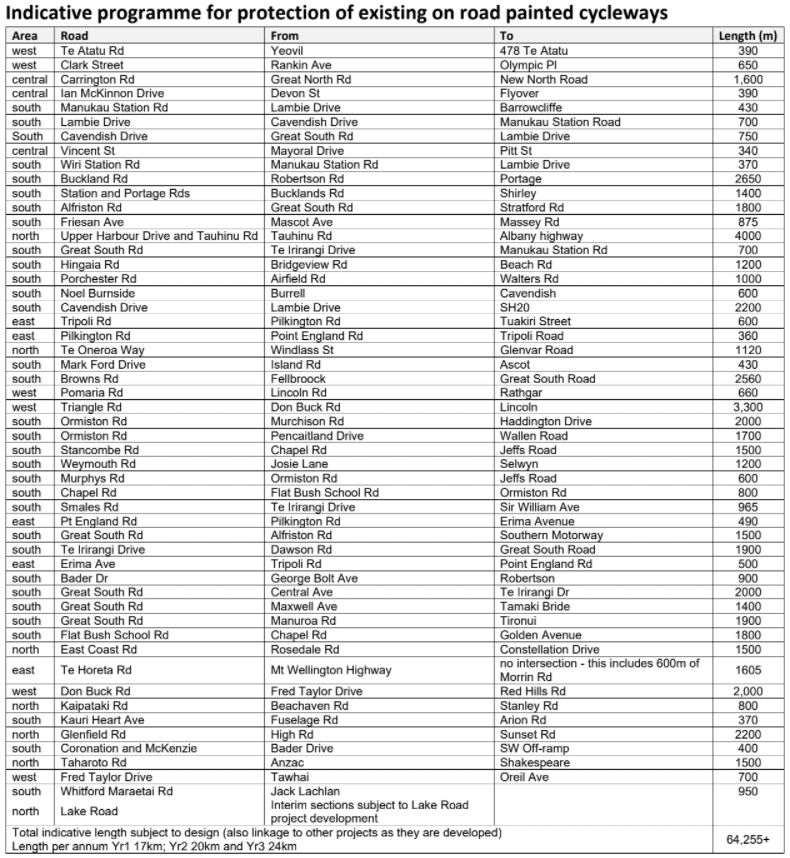
We’ve seen comments in the recent Auckland Transport board papers about it and last week AT officially announced that 60km of painted cycleways across the region will be getting physical protection over the coming three years.
60km of cycling facilities across Auckland will soon be made safer – as the Auckland Transport (AT) Board has approved a proposal to separate existing on-road cycle lanes.
This work, part of AT’s Minor Cycling Programme, will now be delivered over three years and not the original five years stated in the Regional Land Transport Plan 2021-2031 (RLTP). The five-year budget was $30 million.
The programme will improve safety for people on bikes and aims to grow active mode use in Auckland – as part of AT’s commitment to low-carbon transport options.
Protected cycle lanes are dedicated paths for people using bikes. They are physically separated from people driving and people walking, using various forms of separation including planter boxes, concrete kerbs, flex-posts, or berm space.
Adrienne Young-Cooper, Chair of Auckland Transport’s Board of Directors and occasional cyclist, says increasing the safety of existing painted cycleways with physical protection provides a value for money investment in the safety of people on bikes.
“Our research has highlighted the continued need for cyclist separation to reduce the barrier of safety and confidence for cycling growth,” she says.
The protection of the existing cycling facilities has been developed in discussion with Bike Auckland. The barriers used will vary, to ensure the safest option is implemented cost-effectively for each location. They will be installed during the night, with most locations anticipated to take one to three nights to complete
This is an excellent outcome. Protecting existing painted bike lanes is kind of like low hanging fruit as the lanes already exist so there’s no need go through an acrimonious consultation process just to remove a few carparks.
I was somewhat surprised that AT didn’t also provide a map of the cycleways they plan to rollout but they did provide me a list of them.
Using this I’ve pulled together this map with the roads above shown in red along with other parts of the network. Note, there are a few routes in here where AT haven’t yet updated their maps, such as Karangahape Rd and Tamaki Dr.

This is a good programme and hopefully the level of protection being put in is with concrete dividers and not just flexi-sticks.
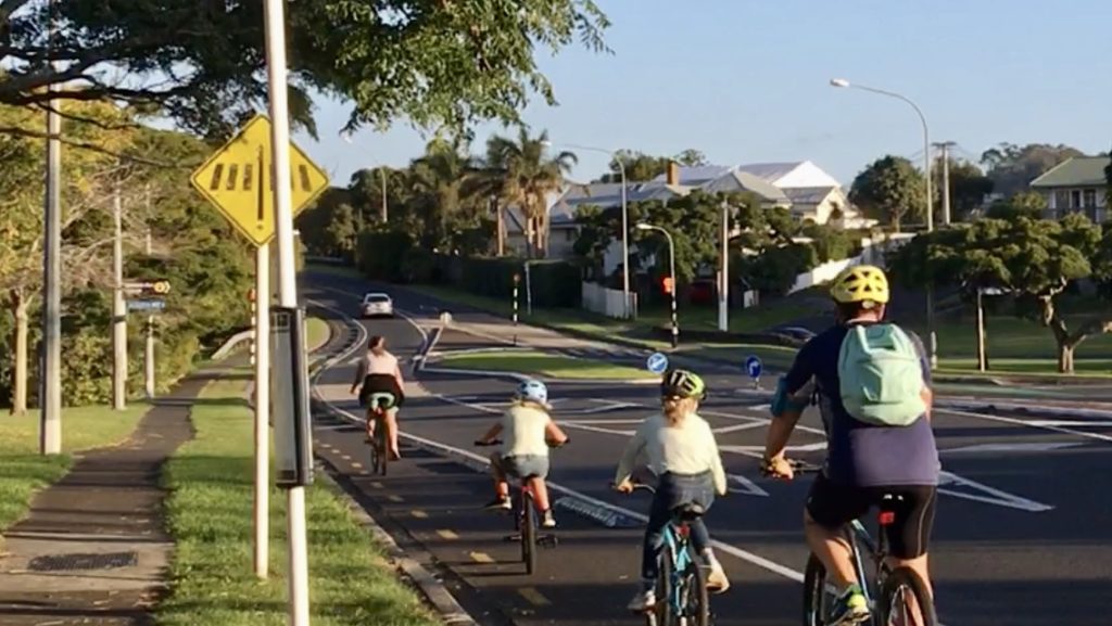
St Lukes Rd is an example of where protection was added to an existing on-road cycleway
Meanwhile, other parts of the network are progressing. For example a recent update from Waka Kotahi shows the progress of Stage 2 of the Glen Innes to Tamaki Dr project
In the west, the New Lynn to Avondale path is progressing too

Image from Jessica Rose
And the St Georges on road Section
This is smooth! pic.twitter.com/gitlgLKZJX
— Malcolm McCracken (@urbanistfromwhk) October 24, 2021
Closer to the city, the much-needed work to upgrade the NW path through Kingsland, separating walkers and cyclists, is now underway
Progress update on the NW Path Upgrade https://t.co/ae0SoEe3QT pic.twitter.com/NK3vqNh8iU
— Malcolm McCracken (@urbanistfromwhk) November 19, 2021
And work on the Tamaki Dr gap, between the Strand and Solent St is underway.
https://twitter.com/aotexaroan/status/1453588125788168193
In the city they announced Project Wave, the interim trial solution to connect the Nelson St cycleway to Quay St will be made permanent
Since May, Auckland Transport (AT) has trialled a new street layout within the Viaduct that includes a cycleway, a one-way system, and increased loading zones.
The Viaduct cycleway has been popular, with around 500 riders recorded on weekdays. The new loading zones and drop-off areas for taxi and rideshare are also well used, and the one-way system has calmed traffic.
We received lots of feedback in support of the trial, but we also acknowledge the concerns expressed by some Viaduct residents and businesses. In this new project phase we’ll bring the cycleway and street enhancements to a higher quality, permanent standard and engage with local concerns.
Most of these changes require investigation and won’t be made until mid-2022, but this month we’ll make some minor improvements to enhance safety and accessibility. No one wants further disruption in the lead-up to Christmas, and so these changes will be low impact –minor asphalt repair, bollard installation, and road marking.

Project WAVE in action on Customs St West.
And finally for this post, this week Auckland Council kicked off consultation on two sections of the Te Whau Pathway which are due to start construction on the two sections below next year.
The two areas that are planned for construction are in the wider sections below
- Section 5 – construction is planned the northern most part of this section, between SH16 and Roberts Field

- Section 2 – the construction here will be between Ken Maunder Park and just east of Rizal Reserve but the path will eventually extend down to Olympic Park with a connection to the New Lynn to Avondale path.

In particular they’re after feedback on the locations and design spaces for play, access and rest along the pathway though they’re doing this for the entire pathway now. The proposals including adding things like lookout pods to some locations along the path

There is more information on the Pathway here, including more detailed maps of the plans for Section 2 and Section 5.

 Processing...
Talk about glass half full.
Just look at that void in the map.. almost the entire isthmus has nothing at all, just that one miserable excuse for a cycle lane on Greenlane East and West. And the Orakei Basin Boardwalk.
The legacy of years of abject failure by AT and everyone else.
And this is 100% pathetic..
“Our research has highlighted the continued need for cyclist separation to reduce the barrier of safety and confidence for cycling growth,” she says.
I mean, if that was a quote from 50 years ago fair enough. But in 2021, we have to report on research.
Give me patience. Another 50 years of it. What an absolute joke.
Yea the network is pathetic, and that not changing anytime soon. AT spending 30million to make the existing cycle ways safer, does nothing to address the far greater danger on the missing links. It also pretty much ensures that AT will build zero new bike infrastructure for the next three years. And the kicker, that anytime bike infrastructure is even suggested moving forward, half a million per kilometre is needed to provide anything, giving AT the license to do nothing.
They are probably doing this to use up some government cycling funding without actually having to take away road space and build anything new. They will no doubt count these upgrades as new cycling infrastructure in some feel good report.
Exactly. 60 million being put into making new bike ways and connecting the missing links would be far more impactful l, but this might upset people.
But don’t worry AT are planting shrubs on bus stop to help climate change.
Ridiculous isn’t it. The map of shame.
They build those very expensive bikeways alongside rail lines, rivers and motorways that are mostly for social weekend outings and not for children riding to school. eg Mangere bike path, Morana bike path, Oakley Creek Bike path, Rotary Park bikeway, Takanini to Drury, GI. to Tamaki Dr, Avondale to New Lynn and worst of all the bikeway Puhinui to the Airport that nobody uses because it stops 1km short of that dangerous airport area. The Otahuhu bikeway to Sylvia Park and connecting schools was dropped after much fanfair and there are few cyclists in South Auckland.
Takanini to Drury was part of the resource consent for the Southern Motorway widening.
Nothing to do with AT when it was mooted, consented and constructed
But those connections are great for commuting. We shouldn’t fight and argue over the crumbs on offer. Expensive bikeways along motorways are great as are protected lanes for kids to get to school. Let’s demand both from Waka Kotahi and AT.
Totally agree. The St Lukes cycle lane is good and then it disappears for a few kilometres, along a stretch of road that cars race through, then becomes a very narrow and dangerous lane along Greenlane. I’m an experienced cyclist and often feel unsafe in this area as cars zoom by.
Having better cycle lanes and networks will really improve safety and encourage cyclists of all abilities to change modes. Really disappointed in the lack of progress by AT.
yep…ride it quite a bit and definitely feel a bit anxious from time to time. The greenlane road section is farcical… feels more dangerous than actually just being in traffic. THe section heading away from greenlane in front of the park entrance is just plane dangerous- always covered in leaves that are just begging me to slide on them:)
It’s great to see these various off-road paths progressing, but it’s telling of Auckland Transport commitment when there are basically no new on-road sections–anywhere that requires parking removal or removal of a vehicle lane which Auckland Transport refuses to do.
The NW upgrade will also likely be counted in their tally of ‘new cycleways’ meaning they’ll pat themselves on the back for achieving the city’s goals and move onto another road widening project somewhere.
Good to see what appears to be a sudden increase in shovels in the ground following a period of relative hiatus.
Conspicuous by its absence, Pt Chev Rd – Meola Rd.
The Kingsland NW path upgrade has placed the merge further east than I’d hoped. Why couldn’t it have been at the west end of the carpark? Where they’re putting it is the bottom of a slope in both directions, and speed restricting surfaces are being installed, possibly alignment too. Such a pain to have to slow at the bottom of a hill, rather than coast up the other side.
The photographed Glen Innes to Tamaki Dr looks unnecessarily wiggly. All bends are dangerous.
There appears to have been nobody working on the St Jude St – Chalmers St – St Georges section of the Avondale-New Lynn path for months. It looks complete but still barricaded off. What’s going on?
Avondale to New Lynn path, will be pretty useless for anyone west of New Lynn honestly, as there are limited ways to access it. The rest of the inner west network, and critically a connection to Henderson and Titirangi are needed, but AT refuse to reallocate space or build new bike infrastructure.
AT now said that bike infrastructure needs to be over designed or they will do nothing. How is this a win?
There is also an active consultation about Rata Ash Street, which ATs long term bike infrastructure plan (consulted on in 2016) indicated would need bike lanes. AT have chosen to not do this, leave the 5 or 2 lane strode, and undermine their own intended bike network, with zero indication for when they will build any part of it.
Indeed, If I want to go on the NW cycleway to the city from Glendene area, it is not easy. Going via New Lynn way seemed to be a really long way which is not practical. The Rata/Ash street would be the most direct route but sadly it is not bike friendly.
Yep. Even getting to New Lynn is tricky and you kinda get pushed away from most direct paths and end up going via Kelston. Taking long cuts to reach a long cut, sucks on a bike.
Lets hope that Te Whau can get completed/fully funded soon- Glendene to NW or to New Lynn/Avondale paths.
The shovel ready protect has been funded by central government, but won’t be finished for years. The connection All the way into New Lynn in particular will be probably be after 2025. Which makes the Ash Rata bit extra annoying.
The bike users can use alternatives, idea, is in general ridiculous when there multiple multi lane car roads doing the same trip.
Te Whau is not fully funded as yet -so yes we do need other options as well.
Gt Nth Rd Waterview – Ash – Rata has a relatively consistent and flat grade, and is relatively straight. While I’ve cycled it a fair bit due to this and consider it to be safer than some other parts of the city, it’s obvious that nobody would let their kids cycle to school on it. It would make a good feeder for Avondale college in addition to east-west commuters, and connect to the wiggly Te Whau path.
Going via New Lynn probably has double the vertical metres with many dangerous bends, in addition to the extra distance. While it is a useful connection, and perhaps in future more so if a path follows the tracks towards Newmarket, I think Ash-Rata is a better local connection and needs building.
Yea 100%. Ash Rata has and will continue to have people riding on it, this just the lay of the land. It’s manageable if you confident. AT has multiple plans that have this road with bike infrastructure connecting, their current safety consultation has ignored this and therefore their own project zero policy. Something is needed here.
Great to see action in the carriageway at last. The fear of upsetting the status quo has meant work has only been offline for years now. These greenways are/will be great assets and a joy but are extremely expensive compared to road space reallocation, as can be seen in the media above. They require full road scale engineering, so only a few km can ever be delivered in any budget.
So this move to, at last, start to fix up our deeply unsafe and inequitable streets and roads is to be lauded, with a great sense of relief and hope that this is just the beginning of the necessary and permanent programme of closing all the gaps across the whole city.
Welcome to the 21st century Auckland Transport.
Hallelujah.
It’s astonishingly difficult to get bike lanes built, despite overwhelming benefits for society and low costs.
The real heroes inside Auckland Transport and Waka Kotahi are those getting this done. History will be very unkind to those who blocked progress and were unable to adapt their engineering and design abilities from car roads to bike roads.
Its just become a whole lot more difficult to get bike infrastructure built. AT are going to build even less for the next few years and are probably going to need to do another round of consultation on the nextwork plans.
The only fast way left, is painted bike gutters and 30kph blanket urban road speeds.
Except with absolutely no enforcement and with even the police ignoring the 30km/h speeds in the central city, it hasn’t made cycling safer. Driving at the speed limit in any of these areas now results in tail gating, honking and dangerous overtaking by drivers who refuse to reduce their speeds. Auckland Transport refused to refuse Nelson and Hobson Street to 30km/h and promised to re-engineer the street–which they’ve also now dropped.
I disagree, it’s far nicer being a pedestrian in the CBD that along a car arterial, where they fly. Even if only a tiny number follow it, it’s still safer.
Let’s automate traffic enforcement then. GPS trackers being mandated is something very achievable.
Isn’t it quite obvious that there should be at least one north/south and one east/west safe cycle lane on the central isthmus? This is a relatively flat area close to the city and many other employment hubs. Even more embarrassing when they are upgrading one of the obvious candidates (Mt Albert Road at Three Kings) and still not bothering.
Very obvious! It’s a huge gap in the network. For East/West it needs to be Mt Albert Road and St Lukes/Balmoral Road. For North/South maybe Dominion Road or Mt Eden Road?
North south it should be New North Road, and Sandringham Road, and Dominion Road, and Mt Eden Road, and Manukau Road, and Great South Road.
East west it should be Newton Road, and View Road, and Valley Rad, and Green Lane, and Selwyn Road, and Mt Albert Road, and Denbigh Road
+100
AT’s job is to provide a safe system for everyone, on all our streets. Back streets can be made safe with LTN’s and placemaking type changes. Arterials need safe protected cycling.
If AT aren’t planning to do so, they are rejecting Vision Zero, and not fulfilling their core task.
Sailor Boy: agree, but are there any planned for the next 3 years for example? They need to start somewhere.
North/south isn’t such an issues as all those roads have bus lanes, but east/west is horrible in patches on Greenlane and on almost all of Mt Albert. I think both those roads should be absolute priority over all of these fancy cycle paths. Too hard I imagine as there isn’t enough room for it as well as 4 lanes of cars, and the stupid Royal Oak roundabout needs to go but I am sure some road boffin thinks it is impossible to replace with lights.
Jimbo,
Several of these corridors are being rebuilt as part of the connected communities programme. I understand that several are meant to be finished by 2024 and all of them are supposed to enable safe cycling
Connected Communities will be quietly dropped like every previous iteration, it’s a stalling tactic and AT have no intention of following through as soon as any plan requires the removal of a lane. Most likely they’ll be deemed too expensive as AT will require any cycle infrastructure is in addition to what exists and therefore require road widening and land purchasing. They’re going down a similar path with the Eastern Busway.
Wow, if this is for real and in my lifetime, I will have safer lanes almost all the way from home in mangere Bridge to Manukau.
Instead of taking longer back roads to feel safer.
Have been seeing more people on bikes along Buckland Rd lately.
https://www.cdc.gov/niosh/topics/hierarchy/default.html
Good. So about $500,000 per km. I’m sure with a steady programme, economies of scale could reduce this significantly. On most arterials, the physical works won’t be any more than this (intersections are additional).
So the difference between protection of a lane at 500,000 per km and the AT estimates usually, which are in the order of magnitude of $10 m per km, amounts to:
– the will to reallocate a lane, and
– the consultation involved when reallocating a lane.
There’s nothing about reallocating a lane or consulting that should be preventing the creation of a safe cycling network. Perhaps it’s time for AT to finally:
– give up its resistance to understanding traffic evaporation, and
– revisit its interpretation of what the LGA actually says about consultation.
Would building 60 million worth of unprotected bike lanes and implementing safer road speeds not be a far more efficient way to get more people on bikes?
I fear that AT are now going decide that given that all bike lanes now need to be protected to a greater degree, they need to do another round of consultations about their proposed (by hardly implemented) bike network plan.
If you keep implementing painted, unprotected lanes then you keep extending a network that only suits the fearless cyclists, and some of the confident cyclists – a few percent of the population in total. Protected lanes can appeal to all of the confident cyclists and most of the “Interested but concerned” part of the population, so we could quickly build a network that would more quickly appeal to half the population and then keep on connecting up more to appeal to the rest.
I disagree with that about painted bike lanes. Particularly if safer speeds can be implemented. Actually fearless riders do so on roads with zero infrastructure. You also miss the point that upgrading a unprotected bike lane a later point can be done if needed. There is so so much of the network that needs any infrastructure to be built, with massive connections missing. Forcing bike infrastructure to cost half a million per kilometre means we get a lot more nothing.
Don’t get me wrong; I understand the point and don’t disagree. Part of this is about what we aim for under AT’s resistance, and what AT would be doing if they could shed the cycling infrastructure-haters. You’re right that getting the space allocated to the cycling is the important first step. They should be able to do that with tactical protection for not much cost, and then make it permanent when the streetscape is renewed. My points are:
1/ getting the space allocated has not been happening for ideological, not for budget or technical reasons
2/ making the lanes actually safe has not been happening for ideological, not for budget or technical reasons
There’s plenty of money for implementing a full, safe cycling network. This is a local road thing, which is what lots of the budget is for. It just takes implementing cycling in every project, which requires road reallocation, and it requires throwing the traffic model out the window and using “decide and provide” planning instead.
But that will take either the CEO to decide to implement best practice, or governance to make him. On what planet does the Board approve, project after project, the spending of our money to change the built environment, without making it safe for our people?
Something like this, for example. Road widening, tree removal, extra turning lanes, but oh no no no we couldn’t put cycling in:
https://at.govt.nz/media/1977252/full-sized-millhouse-dr-and-botany-rd-map.jpg
And this one, why isn’t cycling going in?
https://at.govt.nz/media/1977251/full-sized-cascades-rd-and-botany-rd-map.jpg
Or this one, where they’re putting a shared path in – against the advice in their own TDM – because they refuse to reallocate lane space.
https://at.govt.nz/media/1987191/mip1920-054-updated-drawing.pdf
Every single project involving built environment changes in the street CAN and SHOULD involve putting in the cycling lanes on that stretch of street.
Missing pedestrian legs on all three of those as well.
I completely agree. If we are changing kerb lines or removing any car parking on any arterial route for any project, then safe cycling infrastructure must go in at the same time.
If you keep implementing painted unprotected lanes (well they should probably have some bollards at least) you may appeal to a smaller percentage of cyclists but you may end up with more cyclists because you cover a larger area.
Heidi. Don’t fundamentally understand how you are even slightly optimistic. 2021 has been project after project with basically zero bike infrastructure being announced. AT have decided that bikes are toys to be used on shared paths, not vehicles to be used for transport. That won’t change unless they are preaseured to do so.
Yes I agree every arterial needs robust separated bike lanes. But how can you look this and think that Carrington road with bike lanes needs more investment over Great North Road with none? As someone who lives out west, that need to bike down the nightmarish Ash Rata to acces the shared path network, this really does not feel like a sane use of resources, if anything the people who already have infrastructure are getting more. And worst of all, it gives AT permission to do nothing for years.
Vinegar, my “Good” was mainly because there’s a figure to work with. And I think they should do this, because it’s work that should be part of the programme, and they’ll either learn about how to reduce the cost, or there’ll be more opportunity to expose who and what the barriers are.
We need to:
– work on the rest of the AT budget to get the other cycling improvements needed.
– work on the systemic barriers.
Someone needs to get in front of the Board to discuss Ash and Rata. It’s a great example of AT management’s belligerence and refusal to implement best practice; also a great example of excuses that just don’t stack up when examined. Also, it’s a great example of a project that the Board should have examined closely to understand what the barriers are. Why didn’t they?
Surely this now means any future intersection “safety improvements “,should include separated bike lanes,especially on any roads that have sections of soon to be protected bike lanes. I look forward to all future intersection “safety” improvements, incorporating bike lanes,would only want to spend the money once, right.
In reality ,as has been pointed out,AT are soaking up WK funding, without really upsetting motorists. There is still bound to be plenty of push back on this,though.
What happens to all the painted cycle lanes,that sit outside parked cars,there is one that runs up Onehunga Mall,another on Rockfield Rd?
Yeah what’s with those painted sticks? Was biking along a short stretch of cycle lane on an 80 km/h road with painted sticks, it was terrifying. Is there any situation where the sticks should be preferred?
Lake Rd from Esmonde to Devonport is 5km and the plan is for 950m and subject to a $40m roading project happening?
And again the square root of bugger all for the West.
Inner west in particular gets squat, except the Clark Street section which in typical AT fashion will be made safer but inevitably underperform because there is no safe way to actually access it west of New Lynn.
I’m glad the south is getting a fair shake, but still, damn.
When these changes are made to roads and cycleways is someone at council or AT updating openstreetmap dot org ? It’s useful because almost all 3rd party app makers, mapping orgs and even the likes of Apple and Google update their own data with open streetmap data (because its free) . Not only for road rules and speed limits but for various properties/types of cycle lanes
I feel like AT need to introduce a budget of say $10m a year and have a person in charge of it. The budget can only be used to protect existing cycle lanes. They would have carte blanche to install the stuff where minimum cycle lane widths are met.
“AT needs to introduce a budget of say $10m a year and have a person in charge of it.”
Does AT even have a “cycling team” anymore, or was this swept away in the rush to create a “Customer Experience Division”, that resulted in the mass redundancies of experienced staff?
This program by itself is a good thing, but:
• the key thing is what will happen at intersections. Most bike lanes just end at intersections. If this is not improved this investment will be wasted.
• also is this going to happen in addition to, or instead of expanding the cycling network?
• long term I think it is more productive to expand the network, even with paint only lanes. Roads get periodic maintenance anyway, and they should then be restored with more substantial bike lanes.
I’m also not sure about how ‘easy’ this is. For example, there is a cycleway to be upgraded in Glenfield. That bike lane is currently too narrow so to have a meaningful improvement it not only needs to be protected but also widened. If narrowing the car lanes is feasible, we should ask why that hasn’t been done already.
If you look at the red lines on the map, note how little coverage this actually is. Remember this 10 year plan to build 150km of bike lanes? Even that would have barely make a dent, due to sheer lack of coverage.
“also is this going to happen in addition to, or instead of expanding the cycling network?”
This the key. AT consulted Auckland to death, and created amazing “plans” for bike infrastructure that they could build. As I can tell nothing happens towards actually building these amazing networks. Without expanding the nextwork everywhere, making the bike lanes that exist safer, won’t increase the number of people biking in a meaningful way.
Let’s not pit the needs for children to cycle in protected lanes against the needs for men to cycle in a bigger network of unprotected lanes. We need both protection and extensive coverage. (And I say men because that’s what the stats show. Yet it’s still only some men.)
The UN says we should be spending AT LEAST 20% of the transport budget on walking and cycling. And guess what, NO ONE in AT, WK, or MoT has even advised the Minister of Transport about this.
What we need is AT to step up to understand they have legal obligations to make a safe system, and that this doesn’t somehow exclude cycling just because AT’s dinosaurs want it to. Instead of mining the cycling budget for placemaking and infrastructure upgrades, AT CAN and SHOULD use the local road and renewals and maintenance budgets to make cycling and walking safe.
The projects I linked show that AT is wasting money on “improving traffic flow” when basic safety hasn’t been provided. This is legally challengeable, and if the Board don’t get their a into g and make the CEO step up to Vision Zero, it’s just a matter of time before there will be a legal challenge. The situation cannot continue, because this is entirely illegal and unethical.
Without expansion it will matter very little for children. Most are not near any protected lanes to begin with, and even for the few who are, the existing lanes hardly form a network.
Yup. I just think we must radically agitate for more of both coverage and protection. Divide and conquer is all too effective.
I started biking to school in Nelson in 1990s, aged 7 did so every day until I was, 16. Bike gutters were great then. I don’t know what happened and that now they are apparently worse than nothing, in all contexts, just feels bizarre to me. And once again, bike gutters are the prefect placeholder.
Yes AT are terrible, incompetent, useless, petrol head idiots, but forcing legal change is incredibly difficult and costly. GA or someone else goes and does this, I’ll chip in in a heartbeat.
“The situation cannot continue, because this is entirely illegal and unethical”
2022 will result in pretty much exactly the same amount of bike infrastructure getting built, basically none. The Minsiter is not going to rock the boat, ATs CEO does not care. Change will not just manifest. There will be a string of Ash Rata type calls, where glanced at submissions are ignored.
Anyway, thanks. I’ll keep writing my submissions, not riding my bike.
Vinegar, there are literally twice as many cars on New Zealand roads today as there were thirty years ago, and those cars are on average 30% larger than they used to be.
If we could slash driving rates in half and go back to narrower, lighter cars, then maybe riding in the gutter would be reasonable again.
All forgetting that there are also Connected Communities projects that include protected cycleways? And Pt Chev/ Meolo etc? And what developers are having to put in? We can’t blame Matt for not listing everything besides this specific programme.
These are years from construction, if they even get built, the Pt Chev-Meola Rd project has basically been dumped by AT as it requires carpark removal and lane re-allocation.
Which bit is lane reallocation? It’s 1 lane each way for the entire route from the Westmere roundabout right to St Francis School. The bus lane was an additional lane created from current carparking but would be carparks outside of peak. The main loss would be the central median along Pt Chev Rd.
+1 – at least some progress.
1) On-road unprotected cycle lanes should be banned. They are a death trap (I cycled in NZ for over 30 years) & are not consistent with Vision Zero & dont cater for the groundswell in micromobility that is happening.
2) Adding road section protection for cyclists still fails to address the major safety issue which is at junctions. From a vision zero perspective this can only be resolved by making all movements protected (cars, cycles & peds) at signalised junctions or slowing vehicle speeds < 30kmh at other junction types. We can also close unsafe cross intersections and any unsafe tee junctions by adding central medians.
3) These measures will increase congestion, but then congestion tolls and full pricing of vehicle travel which is currently heavily subsidised can deal with that.
4) We need a new nationwide vision zero/zero carbon transport infrastructure standard for new roads and retrofits. Our narrow 20m road corridors simply aren't fit for purpose where there are higher traffic volumes. The wider main roads are easily offset by higher landuse density
Every train station and school should have protected cycle lanes and 30 kph with road measures to ensure that is the top speed that can be done.
I’d quite like a footpath tbh.
I’m all for improving existing infrastructure, but not at the cost of developing new infrastructure which is needed now. One of my concerns is that a lot of current paths and lanes are too narrow. So currently, if there is a slower cyclist, or cyclists, you might have to move out into a car lane to overtake. Put concrete barriers in and you’re stuck. Hopefully some minimum standard for the width of a path exists, before it’s immortalised in concrete… but I’m not counting on it. Personally I’d rather have a well painted, wide, well designed lane, than some concrete strips, hastily installed at night, in places where they won’t help. I hope there’s some oversight, to stop that happening.
Yes, the width consideration is a very good point.
I don’t know if anyone’s seen this before but earlier today I encountered:
https://storymaps.arcgis.com/stories/6ec8c0769a2d4f42bbfb982796883dd1
i.e. Is Auckland a ’15-minute city’? by Benjamin Walch and Andy Bartle
They focussed on walking rather than walking and/or cycling but the isthmus is pretty bad either way. And the North Shore. And parts of East Auckland.
This is terrible news. Those ‘physical barriers’ on St Lukes Rd nearly killed me tonight. There appeared to be no reflective markers at their beginning (heading towards MOTAT) and even with a bright light I didn’t see them until it was too late. I clipped the first one merging into the painted bike lane which threw me off balance, it was touch and go and I was convinced I was about to hit another one head on and superman straight into the middle of the vehicle lane. Just moments after I recovered two cars went by – it wouldn’t have been entirely their fault if they’d squished me. I hate these barriers even in the daytime but at night with no reflective markers I reckon they’re almost a death trap! Paint the damn lanes and be done with it – I for one do not want physical barriers. It’s just another distraction taking away from overall road awareness when forced into a narrow path with obstacles either side.