For me, the best thing about lockdown, hands-down, has been sharing the road with heaps more other people on bikes than I usually do. I get particularly excited when I see a whole family out on bikes together.
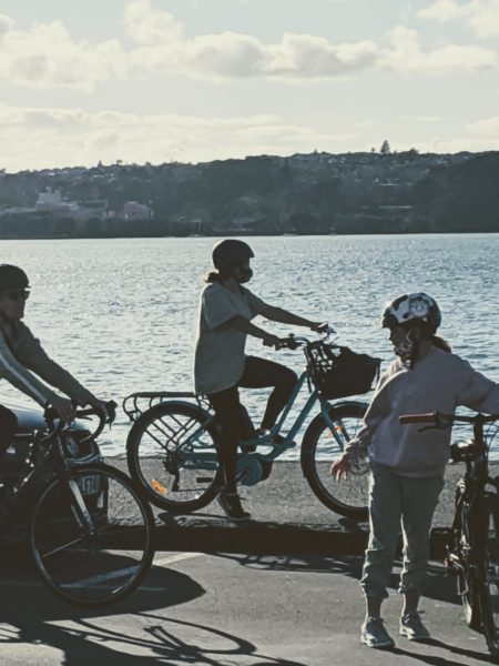
A couple of weekends ago, I went for a ride along the waterfront with the kids who are in my bubble. It was somewhere around the middle of Level 4, when everyone needed something new to do, and the sunny, warm afternoon meant that the streets were busy with people on foot and bike.
I regularly cycle to the city centre through Westhaven, Wynyard Quarter and the Viaduct, and I think of it as one of the few consistently comfortable, low-car bike routes in the central city. But riding the same journey with kids helped me to see it through a whole new lens.
Not my usual perspective.
The waterfront zone
We hit the waterfront at the intersection of Curran Street and Sarsfield Road where a lumpy old section of ‘shared path’ takes you down to the water’s edge. Curran Street technically extends all the way to the Harbour Bridge, where Westhaven Drive begins. I always think of this as the start of Tāmaki’s urban waterfront.
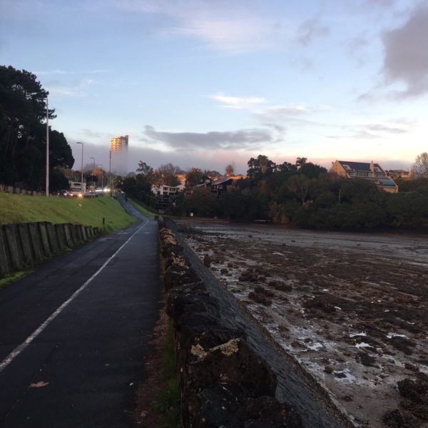
This might be one of the oldest ‘shared paths’ in Auckland.
Curran Street is one-way heading in, from the intersection down to the sea-wall, which means that cars are only able to enter at this point. They can’t exit here, and have to continue on to Wynyard Quarter. The street reverts to two-way for the final, short stretch of road to the bridge, and there’s parking both sides.
Although the one-way works as a traffic filter of sorts, there’s always a steady stream of traffic heading in the direction of the city. Where’s that traffic actually going, I often wonder? Why are people driving down there? From what I can tell, there are three reasons to be driving along this part of the waterfront:
- Yachties heading to carparks: There’s a lot of carparking at the yacht clubs (the Ponsonby Cruising Club, the Richmond Yacht Club and the Royal New Zealand Yacht Squadron are all housed down there, in a sea of asphalt) and Westhaven.
- Recreation: The other users seem to be pretty much just people going for a drive to look at the view. Aucklanders come from all over the city enjoy this cool little strip of waterfront. They park up on the lower part of Curran St and enjoy walking under the bridge, watching the sunset over the inner Waitematā, and getting a glimpse of Rangitoto looming over the North Shore.
- Fishing: The seawall is usually lined with people fishing – only to the west of the bridge, though. I wonder if there’s a rule preventing them from fishing over near the yacht clubs.
Sharing space with cars
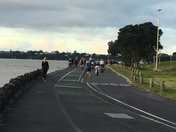
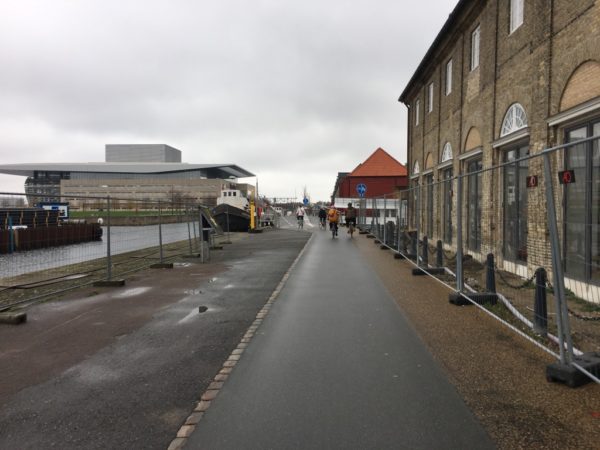
On the sun-drenched L4 afternoon we were there, the footpath was heaving with walkers, runners, fisherpeople, and cars looking for parks. When I’m on my bike by myself, I usually slip off the footpath onto the road, but I soon realised that the younger kids weren’t going to follow me. The number of cars spooked them, and they were more comfortable dodging pedestrians on the footpath than joining me in the traffic.
Covid-19 Level 4 at the Curran St Seawall
So around the corner at Westhaven Drive, we stayed on the boardwalks and didn’t venture onto the road. Being long and straight with good sight-lines, the boardwalks were slightly easier to navigate than the footpath. There were plenty of other people on bikes and scooters dodging pedestrians too, so although it was slightly chaotic people were good about making space for each other. It’s not ideal though: the boardwalks are about 3m wide, which is simply not enough width for a slightly random kid on a bike, a group of people, and a dog, to comfortably pass one another.
Perfectly un-programmed play
Those acres of carparks I mentioned above are all empty in lockdown, and some have been recently refurbished with a silky-smooth asphalt surface. They’re the perfect place for a 14-yr old to ride really, really fast, and a 10-yr-old to practice cycling with no hands.
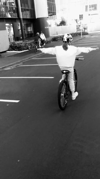
No hands at Westhaven!
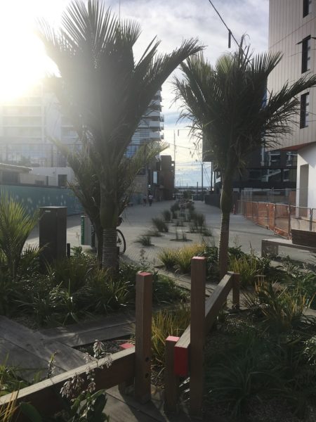
It reminded me of big post-industrial open spaces I’ve come across in much more bike-friendly cities, where un-structured, undesigned open space has been left as is, for people to use it how they wish. An empty stretch of hardstand would probably just become temporary carparking here.
Space to roam is bike-friendly space in Copenhagen
Two waterfronts
Our little group was happy rolling along the roads of Wynyard Quarter. Although they don’t have any cycle infrastructure built in, the streets were particularly low-traffic in Level 4, and the urban form – kerbless, lots of landscaping, short blocks – made us feel comfortable being in the carriageway. There are also beautifully designed car-free spaces that it’s easy to veer off into and explore, like Tīramarama way, and the very skateable new park near Silo Park.
Tīramarama Way, in Wynyard Quarter
The older part of the Viaduct was a different story. With Te Wero bridge up due to Level 4, we had to wend our way around the lagoon which – because the kids still weren’t happy riding on the road – meant navigating narrow paths, ramps, and awkward pinch points. There were lots of other cyclists doing the same, and coming up to Viaduct Harbour Ave we ended up in a bike traffic jam with a couple of guys and a really small kid with training wheels. We all squeezed single-file past some big bollards, power poles and railings to avoid getting onto the road. I turned too hard and narrowly missed falling down some steps towards a lower level of the walkway. Seconds later, I heard a shout behind me, turned around and saw that another woman on a bike had done exactly that.
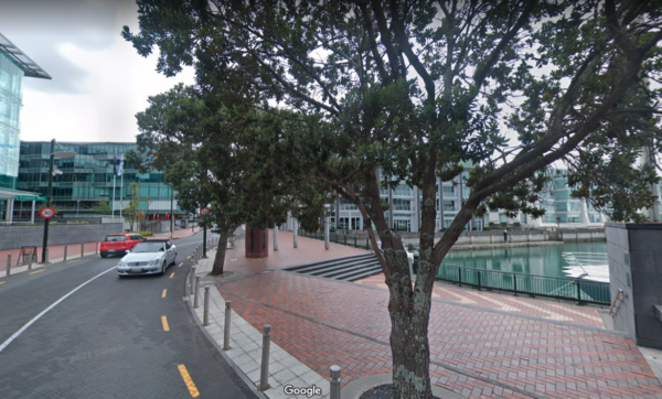
Pinchy, particularly for bikes. (Google street view)
What is a bike lane, anyway?
At Quay St, the only piece of dedicated bike lane on our ride, the kids were ahead of me and I watched them roll along the footpath beside it. They hadn’t even noticed it or recognised what it was. Yes, the design Quay St bike lane can be described as subtle, But I think it had as much to do with the fact that the kids just haven’t experienced ‘bike lanes’ in Auckland, and don’t know what to look for.
Stuff to see, places to play
We paused at Te Wānangaby the ferry terminal, where a few small kids were rolling around on the beautiful green net installation – Kōrimurimu by Tessa Harris – and peered over the railings to look at the mussel strings that have been installed in the water below.
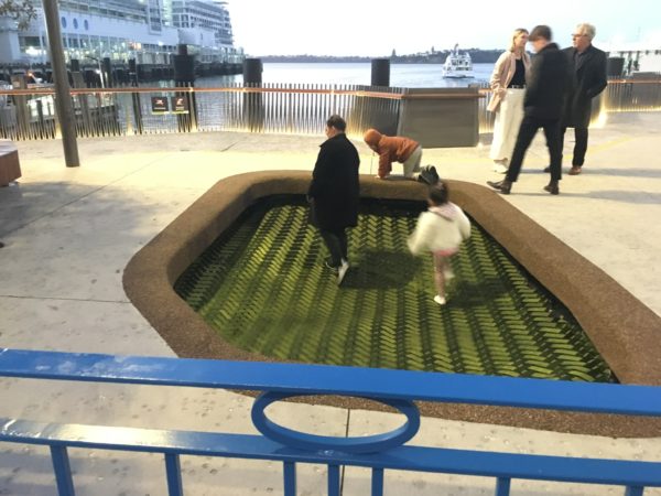
Kōrimurimu, photo taken back in early August
We crossed the road to Te Komititanga and did figure-eights over Tāmaki’s vast welcome mat. I love the scale and simplicity of Te Komititanga, and it’s a lot of fun to zip through on a bike. It feels like there’s room for everyone.
At Queens Wharf, we found another wide open play-space: a long clear concrete strip to zoom along, a ramp here and platform there to jump over, a row of cats-eyes to slalom between. We had a rest at Michael Parekōwhai’s Lighthouse, and enjoyed the feeling of being way out on the water’s edge, teetering into the harbour.
On our way back, we realised that the pop-up pump track was open in the eastern viaduct, and the 10-yr-old got a few loops in.
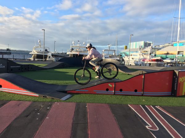
Surprised but happy to see the pump track open in L4.
The home stretch
The crowds had thinned on the ride back; it was starting to get dark and the wind had picked up. We took space on boardwalks and footpaths more confidently, and the kids knew the way by then.
There are so many beautiful, exciting and interesting places and spaces to encounter along the waterfront. We’re good at art and expressions of cultural landscape, here. The experience of getting between them by bike was complicated and at times frustrating, but many people, including lots of families, were still out doing it, even though the journey from Curran St to Queens Wharf simply isn’t designed for bikes. Rather, it’s designed on the assumption that bikes will share with cars or with people on foot.
It seemed like a missed opportunity to create a bit of extra space, particularly in a L4 situation when so many people are looking for things to do in the city. Curran St to Queen’s Wharf is an ideal recreational bike ride: a little far on foot for a family with various humans of different speeds – but perfectly doable on bikes.
In Oslo, a complex and formerly disconnected series of waterfront spaces are linked together by cycle lanes and footpaths that traverse a 10km strip of water’s edge. Some of the spaces are highly designed, some are simple expanses of asphalt and concrete. But there’s space for everyone, and it all connects together – the city’s playground.
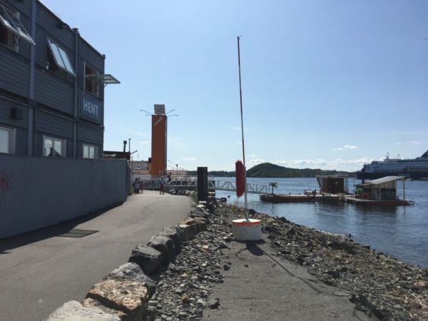
Simple infrastructure and a bright orange wayfinding tower on Oslo’s urban waterfront
I’d love to see some simple changes, or a tactical urbanism project exploring a connected cycling route between Quay St and the ‘start’ of the waterfront at Curran St. I don’t think it would take much to turn it into a place that feels properly safe and linked-up. It’s not fair to people on foot to share the limited car-free space with those on bikes and scooters – that’s unsafe for pedestrians. Bikes need room, or their own infrastructure, so that everyone can travel easily and safely. And a bit of extra traffic calming and the reallocation of some parking space could open it up to the keen, but less confident, people on bikes, giving them access to a really special part of Tāmaki landscape.
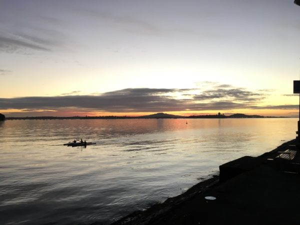
Rangitoto over the Waitematā, from Westhaven Drive and the end of the Harbour Bridge
Edited to add: we kept to our bubble, kept our distance wherever we could, and our adults also wore masks, which wasn’t strictly required. The well-worn point is that social distancing in public space is difficult when much of the available space is still dedicated to cars.

 Processing...
So you and the kids went out for a short local ride which is well within the guidelines for a L4 activity. Nice, I hope you enjoyed yourselves.
It is a shame that activities that in any well designed city would be completely harmless carry the level of inconvenience that you experienced. Hopefully we can change this.
Have a great day.
Thanks Marita, great article. I had a very similar experience with my kids a few years ago riding this same route. It was a beautiful day and we had so many great moments along the way, but the best really was when, on the fully separated path alongside the port’s red fence, Miss 5 said “Daddy, this is like being in the car, only I get to go where I want to”. Freedom for a kid really is two wheels.
Unfortunately the risky parts of the ride (we were in full traffic, non-lockdown times) really were dangerous. Being overtaken trucks on Beaumont Street in Wynyard was the low point, making me go into a hyper-protective position on the road. Traversing the entrance to Princes Wharf was pretty bad at that time. Progress towards a safe, connected network is painfully slow in Auckland.
Lockdown cycling has been a high point for many I suspect. We’ve been out plenty, masks and all, and while it’s been good for the body and mind during lockdown, it also highlights the contrast between safe road conditions (little traffic) and ‘normal’, aka life-threatening, Auckland roads.
If Viaduct doesn’t even have safe links, West Auckland and the like is going to be unsafe for a long time to come. We’ve just had Glen Eden town Centre roads “upgraded” as a major safety project, but with zero bike provision. So much wasted opportunity to create safe networks across the city.
Perhaps you could explain the rules rather than sounding like you’re on mikes moan, Dr James Hay.
Cycling is allowed in L4 which is what they did. If you feel riding around a benign pump track is should be classified as a ‘dangerous activity’ I fear for society.
Also, I thought wearing masks while running or cycling had been proved totally ineffectual.
Good post, Marita. I don’t think the priorities for how to use the area have been publicly discussed and considered.
We needed a respectful conversation about the importance of making sure the waterfront is accessible – sustainably – by all Aucklanders AND making sure that it provides an affordable opportunity for any Aucklander to sail.
Smaller cheaper berths instead of large berths for gin palaces and superyachts.
Bus stops at the bottom of Curran St and Shelly Beach Rd.
Secure bike stands, and secure storage for cargo bikes.
Carparking reduced and priced, so the land can be used better AND to reduce the traffic so it’s safer for walking and cycling.
Instead, the area seems to have been developed without regard to transport, sustainability or equity.
The connection between west heaven to Wynyard Quarter quarter needs improvement. Ideally build a shortcut walk behind swashbuckler restaurant thru silo marina.
In long term the yacht squadron extension should have a bridge to connect back to north of silo park into a big cycle and walking loop.
What a very pleasant, well written piece.
I often run along that area and I rarely have any problems with people or vehicles.
During lockdown however, I had so many problems with crowds of walkers and cyclists that I’ll be avoiding it until lockdown ends.
I have walked the route and it is a bit messy. Time for a bit of joined up thinking. I was down on the water front on Friday watched 4 or 5 Ram utes come off a vehicle carrier in the course of a couple of minutes. I note the oil price is over 80 dollars per barrel. Industry experts are predicting 100.dollars by Christmas. So that probably means the end of October or alternatively the price will drop. I don’t have too much faith in industry experts they always have to much skin in the game. Local active mode pathways will give families a cheaper alternative than piling the bikes onto the double cabbed ute and driving to a more distant one.
That pinch point on Viaduct Harbour Avenue is horrible, even without the extra lockdown crowds.
The bollards all along the side (at least these keep the rat-running cars at a distance), the steps popping up right there, a poorly positioned tree with low branch, a sculpture supported by three posts, and some weird, huge round post thing that does nothing but block your vision. All these obstacles and the one metre gap? I know – let’s put a damn ROAD SIGN here as well!
Someone should fix this.
https://www.google.co.nz/maps/@-36.8452682,174.7580059,3a,75y,54.92h,71.29t/data=!3m6!1e1!3m4!1sHp7cNTBW9jvW4BkWT1Jr2Q!2e0!7i16384!8i8192
It should be a low traffic area where you would cycle on the road.
Yes. And some speed enforcement would go a long way. The Police and WK focusing only on high speed instead of what the safety review called “low level speeding” is preventing equitable use of the streets.
Viaduct Harbour Avenue really isn’t nice for cycling. It’s portrayed as a “quiet parallel alternative” to Fanshawe Street but this is untrue. It carries too much motor traffic and is not particularly parallel.
It’s a classic case of “dual network” cycle provision, where the “less confident cyclists” use the shared footway and the “more confident cyclists” ride with traffic, in a vehicular cycling fashion.
This approach was superseded years ago, at least in design guidance. Dual networks don’t work. Cycling needs a coherent, accessible joined-up network, same as walking or driving.
It looks pretty parallel to me. And there is no reason to have a lot of car traffic on Viaduct Avenue. It should not be usable for car drivers to bypass Fanshawe Street.
Cycling on the road on quiet streets and having parallel main routes for cycling and driving are both pretty standard in the Netherlands.
Some good insights from the perspective of young riders. Yes until they can confidently ride a whole route we haven’t really achieved safe cycling in Auckland. It’s getting there slowly.
This is a problem along the whole Waterfront. I’ve long been a fan of the idea of a proper boardwalk at least another 5m or so out into Tamaki Drive, but never quite figured out how you would use this to enhance natural features like the lava flows instead of just building over them.
Otherwise the huge stretches between Kelly Ts > Mission Bay and Mission Bay > St Heliers will rapidly get to the point where they are no longer fit for purpose.