When complete the City Rail Link will transform how many people access and move around the city centre. Light rail, the Northern Path and other cycling improvements will be the same if they go ahead.
Even with these projects many people, and many more than do so today, will access the city centre by bus and I’m sure everyone would agree that the experience of catching buses needs to be improved. At the same time there is a need to implement the City Centre Master Plan (CCMP) as well as drive mode-shift and reduce emissions.

Current City Centre Bus Routes
Today Auckland Transport are releasing their proposed plan for buses in the City Centre which would represent probably the most significant change to buses since the launch of the new network a few years ago. However this isn’t going to be a quick change as they say will take 5-10 years to fully deliver.
The plan has three steps
- Step 1 – Create two high quality dedicated east-west bus corridors on Customs Street/Fanshawe Street and Wellesley Street, with fewer, higher quality and safer stops.
- Step 2 – Establish dedicated facilities for urban and inter-regional bus passengers. These facilities would include safe and comfortable waiting spaces, facilities for drivers, and bus charging facilities. Possible locations for these are in the Wynyard Quarter, Beach Road, Learning Quarter and Downtown areas.
- Step 3 – Make changes to services so that bus routes run through the city centre rather than only to the city centre. This would free up at least 1 kilometre of kerbside space that could be used for people to share and enjoy.
A summary of it is here:
https://www.youtube.com/watch?v=ij_ELJClK24
Looking at the steps in more detail
STEP 1
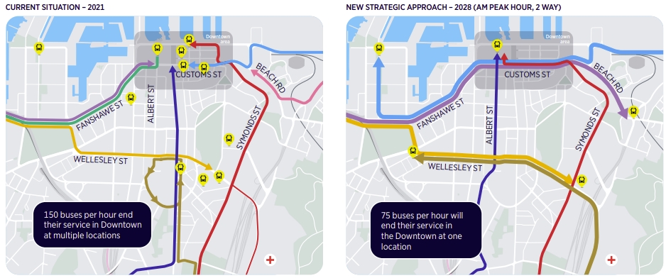
AT say they’ll create two high-quality east-west bus corridors on Customs St and Wellesley St. This will come with better quality bus stops.
Both of these corridors were identified as the main east-west bus routes way back in 2014 with Wellesley being fully bus only either side of Queen St. It seems like a massive missed opportunity that these Wellesley St plans weren’t implemented at the same time the road was reopened following the CRL closure. Also the image below from that time and far better quality than what’s included in this new plan.

For Customs St, the CCMP opens up new opportunities as a key part of the plan is stopping general traffic using the city as a thoroughfare. This potentially opens up a lot of opportunity to reallocate space to pedestrians, bikes and improved bus facilities.
Step 2 and Step 3
These two steps are interrelated so I’ll cover them together.
Currently buses terminate in the city centre all over the place and it can be a confusing mess to work out where to go to catch your bus from. The map below shows just the places where buses terminate but on top of this there are through services like the link buses.

You may recall earlier this year there was a lot of focus on the potential sale of the Downtown Carpark and Auckland Transport wanting to include a bus facility in the redevelopment. More recently they’ve agreed that facility could go on the street if the Hobson St flyover was removed (another part of the CCMP) – bidders for the carpark have to come up with how to incorporate the bus facility.
It’s this bus plan that’s a key reason behind the push for the bus interchange on or around the downtown site. But it turns out they don’t just want one off-street facility, they want up to five of them. AT also point to the Manukau bus station as an example of the kind of experience they want to deliver.
AT would then simplify bus operating patterns in the city centre with buses terminating at one of these facilities. This would also see many bus routes being terminating on the opposite side of the city from where they enter which will help in making them more useful.

But I do have a couple of big concerns about these off-street facilities as it seems the plan is largely contingent on them happening. These facilities are going to be big and expensive projects – the Regional Land Transport Programme allocates over $350 million for these and some of the other bus improvements in the city. Yet most people are still likely to be boarding their bus at an on-street stop and so this is a lot of money to use up prime city centre land for what is essentially bus layover space.
The size of these facilities means there’s a good chance of project slippage and with service improvements relying on these facilities being in place, there’s a good chance those service improvements will also be delayed.
At the very least it seems like the number of facilities should reduce with the western and eastern facilities being combined. That would see
- the Manukau Rd services extended to Wynyard – it also seems odd that Manukau Rd services would require two transfers to get to Wynyard.
- the two North Shore routes combined into a single facility on the eastern side – AT do suggest these could potentially be combined

Even if everything goes right, AT don’t expect these improvements to be completed until 2028. That seems simply too far away given the scale of change that we need.

Finally it’s worth mentioning some of the things that are missing from the plan. It’s notable that there’s only one mention of ‘mode-shift’ and only two mentions of ‘climate change’ in the document and all three of these are in the introduction by AT CEO Shane Ellison. Though talk about reducing emissions is mentioned a bit more it’s only really in relation to bus emissions directly. It seems to me that AT are missing a critical aspect in that they’re just trying to meet growth and to make buses better to get people out of their cars. This is reflected in their forecast below.
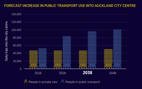
Notably, since 2016, the number of people arriving by car in the city centre during the morning peak fell from about 42,000 in 2016 to 35,000 in 2020 just before COVID hit. With current and future improvements to the city in making it more people friendly and with less space dedicated to the movement and storage of cars, there’s no reason to expect this trend wouldn’t continue. Yet AT are forecasting car numbers to increase.

 Processing...
Good clear video I must say. Interesting bus shelter thoughts. I think the freeing up of curb space from ~50%? of buses running through is a great outcome.
This crossing over model is good, means us users can arrive and depart from key central points and not just be dumped at some near edge of the city. More opportunity for good transfers, and fewer buses parked all over city streets.
What i don’t get though is why they want customers at these new edge depots? How does that help, and who wants to go to them? Surely be better, and more affordable, to seperate alighting and boarding from from layover, charging, driver needs etc.
It seems they want to build train stations, rather than bus depots? The competitive advantage of urban urban transit is the ability to take you right to the front door, with a minimum of expensive monument building, by having the necessary kit offline at a remove from the public.
I am a bit confused about Wellesley street: who wants to be dumped in Midtown these days? My bus terminates there and it adds an extra 10-15 minutes to get to Britomart / Spark Arena / Wynyard / etc. This change doesn’t seem to address this issue at all, I am sure AT did originally have plans to fix this?
All buses need to run the length of the city, running the width doesn’t really help at all, its just as useless as the current setup.
It runs right past what will be the busiest station on the rail network, the buses that run down Symonds St to Britomart are going to be the less connected ones.
Assuming you aren’t going into the city to get rail out, that doesn’t really help. Symonds Street to Britomart would be much more useful. Why not Albert Street?
Only those two big universities there i guess.
The thought of buses laid up around Wynyard, to name one area, is completely counter productive to the efforts the council have gone to to make that area attractive. Not to mention the learning quarter, wherever that is, or Beach Rd.
Cheap though, and nasty.
Perhaps rename Auckland; “The City of Bus Depots”!
I don’t think buses will ruin Wynyard. Cars have done that already.
Wynyard a lost cause already Derek?
Nice elements there but it could be far better. I don’t see our Council doing anything about the problem of too much parking, nor of the illegal parking. They had the opportunity for it to be a really walkable area with very low traffic movements, and squandered it.
Remember the target for the Wynyard Qtr was 30% car mode share by 2030. Only AT would have thought the best way to achieve this is by letting rampant car mode share growth occur, and then try and reduce it.
Maybe it was huge predicted tram patronage that would have enabled them to claim 30% car mode share? It couldn’t have been any of their other policies.
Right now the red link bus and line 75 already terminate in Wynyard Quarter.
Wynyard is a good place to terminate; is literally end of the line. Also you know there’s a depot there already?
There was a depot, but it looks like NZ Bus sold of most of it off. Far better return on investor capital to sell properties and use public spaces, for free to store your fleet.
Public streets should not be parking areas for heavy vehicles. Remember we have 20 years to cycle through the diesel fleet yet.
It was sold off years ago, they only lease it.
I think it’s big enough there to not be a problem & as per other comments, some do already and cars etc there already. It should be fine.
The buses of the future will be laid up where the charging stations are located, an unfortunate cost of emissions reductions.
It seems AT still haven’t found a copy of the City Centre Master Plan to read. No, general traffic levels will not stay the same. Yes, it is your job to make this happen through street reallocation to more spatially efficient, valuable, and pleasing uses.
Thank-you
“AT are forecasting car numbers to increase.”
So who’s holding them responsible for this nonsense? Twitter?
Who indeed? This isn’t a minor error, it stems from fundamental misconceptions; examples below. What really stuns me is that the AT Board and Councillors didn’t do their job at questioning it sufficiently, and have lain themselves wide open to legal challenge. Oh, for quality governance.
“AT often allows for capacity reductions – as long as it’s not on the arterials.”
“In practice, it is also likely that gains from deterring car travel through lane reallocation alone would be largely offset by the increase in emissions associated with increased congestion and diversion amongst the remaining traffic.”
“Fundamentally, investment in infrastructure or services only has a very minor impact on total emissions, whether positive or negative. Even the biggest projects may only account for changes in the order of one percent of total.”
Yep, that forecast of general traffic volume is the fundamental problem with AT. They continue to pretend that general traffic is a constant that needs to be accommodated. Bring on the legal challenges – it seems it will be the only way to get them to change. And this is the city centre – the EASIEST possible area to achieve modeshift. As Matt says it’s already happening, yet they still can’t bring themselves to plan for it! Infuriating…
Agree, but bus experts would understand this. What’s going on inside AT?
Isn’t it a bit obvious that as we increase CBD density, more people will equal more cars.
So defraying the buses all around the city, with the same amount of vehicle traffic or more, is going to make bus travel to the city quicker how?
Imagine being able to make the old, pre-Britomart bus station look like an exercise in elegance and logistical simplicity. AT have managed it.
It can’t happen with same traffic level, basic geometry.
Why are they making it harder for themselves with this dishonesty/self-delusion?
This is likely the model at work. The whole industry needs better tools. Slavishly following models with opaque/dated inputs to supposedly predict the future is beyond absurd.
Modelling needs to be flipped on it head: with outputs selected, ie the city we want, like the CCMP, then the machine can help us create the settings to get there.
This is contemporary transport planning: Decide and Provide (or Vision and Validate), not the 1960s dumb adding machine of Predict and Provide.
It was always a mistake to abrogate city planning to a simple traffic formula, look around, the result of this reductionism is plain to see.
Always be sceptical of anyone who claims they can understand complex systems with a single calculation, whether it’s traffic modelling or carbon trading. Is junk science that will always be too limited to result in great outcomes.
They always leave out what doesn’t fit, is hard to quantify, is messy, ie most of what’s important to humans and life in general.
Step 3 is a great idea. By freeing up kerb space we will no longer need light rail which will save billions. Clearly Bussnake was always bullshit.
This plan requires LR Miffy; note Queen St is freed up for it.
Yes you can expect the justification for light rail to change several more times yet. AT has a solution looking for a problem.
Probably best to look for what works on other parts of the network. Manukau bus station with its integration with Intercity buses is great. But involves a fair bit of looping and shunting. Otahuhu station is not just off street but off road with a terminating bus stop on one side a loop and bus layover then set stops for new and through services on the other. So you need to cross the road to change services or transferring to rail. Otara is very cute I call it an off street bidirectional with one platform however no terminating services makes it easy and only one bus lane to cross. Its being there for many years.
You need to be alert at Mangere Town centre. I call it an off street unidirectional but no set stops. You just wait till your bus number appears but be careful to check direction as well. Buses come in at one end then gradually move forward you are never sure whether you should walk to them or whether the will come to you. Lots of looping and on street layovers makes it a bit untidy. However no need to cross. I have looked at the new bus stops on Albert Street and Quay street and would call them on road. So I suppose it comes down to what you can fit in. Something like Manukau or Otahuhu Station would be best but its hard to see how to fit it in. Given that buses will not be terminating I would suggest something like Mangere or even better Otara could work if we could reallocate a couple of lanes and create enough priority to keep the buses moving. It could get a lot of services into the one spot.
“But I do have a couple of big concerns about these off-street facilities as it seems the plan is largely contingent on them happening.”
I have an even bigger concern and that is, are they really necessary? Surely, if PT is optimised people will be getting off one frequent service to get on another? Turn up and go frequency? Where does a terminal with sit down facilities fit into that equation?
Let’s look at the NEX1 that is currently operating at 15min frequencies. If volumes double why would you need an expensive terminal for a wait of up to 7 minutes?
I suspect though that PT frequencies will be far greater than this. Logic and arithmetic will dictate that there cannot be more cars and more buses on the current city streets. It will just turn into the same abomination that is lower Queen St, with cars and buses stuck in a single lane. There won’t be a need for wasteful terminals.
Where did the plan for 25% car mode share in the city by 2050 go?
I’d love to see the international city on which this model is based, as I have never seen such grandiose operations anywhere, even where PT mode share is phenomenal.
The current inner bus system is totally confusing and not user friendly to any person who arrives on an InterCity coach and is not familiar with Auckland’s bus network.
The proposed plan may simplify things a bit in theory for the locals but doesn’t include where inter-regional and long distance and sightseeing coaches will terminate and depart and how to connect with onward metro rail and bus to their final destination.
The way I see it There are 4 main areas that buses should take people in the City Centre. Wynyard Quarter, Britomart, Aotea Square (Midtown) and the University area. Of those the University area and Wynyard Quarter are more logical for layover areas. Britomart and Aotea Square should have no buses terminating there.
Why not try and route buses through two or three of these areas? So a way it could be is
* North Shore Buses come in on Fanshaw street, Follow Custom street past Britomart to University Depot.
*Onewa Road buses come in on Fanshaw Street, Follow Wellesley street past Aotea Square to University Depot
*Western buses come in on Albert Street, Go through Aotea Square then Britomart to University Depot
*Central buses come in on Symonds Street, Go through University then Britomart to Wynyard depot.
*Buses from Newmarket come in past Hospital, Through University follows Wellesley Street though Aotea Square to Wynyard Depot
*Tamaki Drive buses come in on Custom Street, through Britomart to Wynyard Depot
That would put most opportunities to transfer as a simple hop off one bus, get on another possibility with limited walking. It would also put the bus routes past either Britomart or Aotea Square rail stations facilitating transfers there as well.
That dogleg from Quay Street to Beach Road for Eastern services really is a thing of beauty isn’t it.
“Create two high quality dedicated east-west bus corridors on Customs Street/Fanshawe Street and Wellesley Street, with fewer, higher quality and safer stops.”
Why would you have fewer stops when you want more people on buses? The delay for buses is largely not caused by stops, but by traffic. What question is this a solution for?
Safer stops? What is unsafe about the current stops? I am struggling to remember the last time that I read of someone being killed at a bus stop, but I have only been in Auckland 40 years. What is unsafe about a bus pulling right up to a footpath and people alighting?
I’m sorry, but I have little faith that these changes will be for the benefit of bus users, but for some other undeclared reasons. As Matt and others have said, why was Wellesley St recently restored much the same as it always was? With the 82 changeover with the NEX1 at Victoria Park, why was the connection moved 150m up the street. It’s hard to imagine it was because Genesis did not want dirty diesel fumes in their corporate office when they spew particulates all over Huntly.
And delivery by 2028. It is little wonder that the emissions reductions target is 1%. AT are doing and plan to do little before the end of the decade.
Fewer stops allows them to be better located, with the services faster and more reliable. It also makes connections shorter and more direct. Same reason the northern busway only has six stations and not twenty five.
Bus congestion at stops is a thing, as is congestion on the paths circulating around in traffic to get to various stops. Bus lanes are relatively effective on a straight corridor but not when you are making left and right turns and going around all over the place.
John, you are comparing apples with pears. The Northern bus way has six stops before it gets to the city and then it has four or five stops in the city including Lower Albert St. And why does it have that many stops in the city? Because there are significant population areas around each of those stops and this will only become more so with growth upwards throughout the Wynyard Qtr and along and behind Fanshawe St. Passengers want a reasonable walk up distance. With the double deckers they can unload a handful of people much more quickly than they can 20 or 30, so more frequent stops is not an issue.
Its not bus stops that make buses unreliable, its the traffic and traffic lights. The NEX is impeded by the significant volume of cars entering that street.
The Northern bus way is an example of what should be avoided. Some of these stations are poorly located. Matt, in talking about light rail has postulated that there should be a station serving Westfield mall. Albany is a commuter station and little else. It relies heavily on a park and ride to sustain growth and this operates to the detriment of many others trying to access the station.
If Auckland is to achieve emissions reductions we need a PT transport system where people use it for short and long trips given that the majority of trips are shorter ones. Taking out bus stops seems counter productive.
Just need right balance or stops vs. speed and route directness etc it’s not black or white thing.
Its not clear but it seems like bus services for inner western suburbs like of Ponsonby, Herne Bay, Westmere etc are planned to become even worse than currently with the simplification of bus operating patterns??
If you ask me the number of bus interchange facilities in this plan should be cut down to 2 – one at Downtown and one at the Universities.
Why downtown and not Wynyard?
Essentially I’m concerned about how an off-street bus interchange would fit in with the surrounding mixed-use development, and whether light rail would have any bearing on buses going to Wynyard.
With the closing of Quay and Customs Streets to through traffic, how is east-west traffic going to transit through town. For traffic coming from the Shore and points west of St Lukes it is a piece of cake because there are motorway exits. But for the rest it will involve lengthy detours taking in parts of town that probably don’t really want trucks etc passing through their precincts.
Using the bypass that was built at considerable expense 14 years ago, namely the Port to Northern motorway ramps. Also I don’t think the CCMP has Customs St being closed to through traffic.