This is a guest post by reader Andy B
The best route for a second crossing of the Waitemata Harbour is back on the agenda. This week the government signalled a ‘rethink’ of the pedestrian/cycle bridge and work going into a tunnel crossing of the harbour as part of the whole network approach. Given the subtle, but significant, change in language seen from the government over the last 6 months on a number of projects (particularly City-to-Mangere Light Rail) now is the time to really think about what the purpose of a second crossing should be.
What is the current proposal?
![]()
The ‘Potential Future Rapid Transport Network’ map above sets out a high level alignment that connects Albany to the Central City with a Takapuna spur. The 2020 Waka Kotahi NZTA business case is the most recent study in the public domain which GA critiqued in their April 8th blog. GA gave some great analysis of the shortlisted options for rail, which either replicated the busway alignment or tunnelled under one of the widest sections of the harbour. The goal appears to be about getting to Takapuna as the primary priority.
There have been other options looked at over the decades including a direct tunnel to Britomart, a tunnel landing in the Grafton Gully and even options through Devonport.
Changing priorities
The government over the last few months has subtly changed the priorities (at least in their language) for transport projects. The Transport Minister, when announcing the Mangere light rail, included a change in rhetoric which (and I paraphrase) switched from ‘city to airport as fast as possible’ to ‘connecting up the bits along the way’. For Mangere light rail that means a focus on the developments Kāinga Ora and Panuku are working on (11,000 planned homes at Roskill Development, 10,000 planned homes at Mangere Development and Transform Onehunga) and unlocking areas with existing poor transport.
The Establishment Unit for Mangere light rail has been given a wider remit to look at compatibility with future stages. This GA article shed some light on the considerations that the unit has which include all the good things we know and dream of; mode shift, emission reductions, land use & transport integration and the role transport has on responding to enabled growth (up-zoned areas).
To quote the light rail website
“Light rail is much more than a transport project”
A Better Route
So with all this in mind, I think that we need to rethink rail to the north shore from ‘city to the north as fast as possible’ to ‘connecting up the bits along the way’. Make it much more than a transport project and consider how the route could better connect areas of existing density, enable future growth, catalyse mode shift and actually make some inroads on emissions.
In my view, it simply needs more stations and more catchments. It needs to go to places that people live. It should take a network approach and intersect, rather than replicate, the Northern Busway. Takapuna, Akoranga (Busway), Northcote, Birkenhead, Ponsonby, Freemans Bay and into the Central City (Aotea Square).
This alignment is approximately 11km, 1.5km longer than the Waka Kotahi option, but with seven stations rather than four. Each station has a catchment, an existing critical mass and a zoned capacity for further intensification. The extra stations are possible because the alignment doesn’t have more than half of its corridor under water.
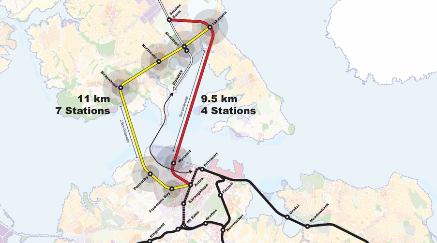
Will it be more expensive? The tunnelling won’t be, but the stations will because stations are expensive components of transport projects and having more stations therefore costs more. But stations are also where people get on; where TOD (Transit Orientated Development) happens and where the most opportunity for low-carbon urban life is created. If we are going to actually create vibrant and sustainable urban centres then tunnelling for 5km under water to get to one centre isn’t effective.
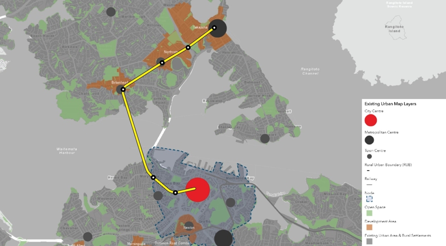
It better enables councils own urban development strategy by linking up more of its ‘development areas’ and proving more stations in the high growth area of the central city fringe. The combined population growth of the three North Shore development areas is forecast to be over 22,000 people by 2048. Servicing this enabled growth with good public transport is vital to their success and likely to see the forecast growth happen quicker.
The case for each station
Takapuna – Takapuna is a Metropolitan Centre; it has a skyscraper and a beach. Panuku are leading a ‘Regenerate Takapuna Central’ framework which has some interesting proposals like the 40 Anzac Street car park redevelopment. The councils’ development strategy identifies a further enabled housing capacity (zoned) of 10,430 dwellings. There is a strong case for Takapuna, as all the Waka Kotahi business cases allude to, that it deserves a station on any North Shore rail project and I agree.
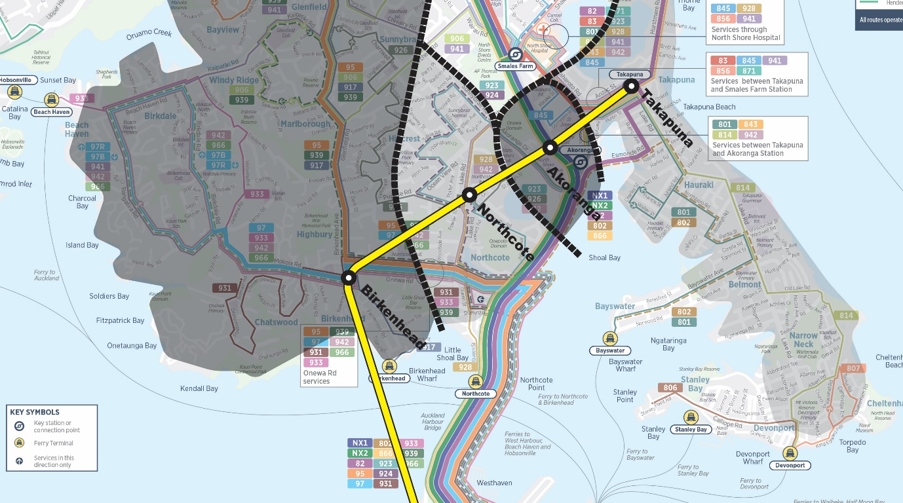
Akoranga – Akoranga does not have a great walkable catchment (thanks motorway) but it does provide the interchange into the Northern Busway and good connection to the AUT campus.
Northcote – Northcote is undergoing significant development right now. Kāinga Ora are masterplanning for 1500+ dwellings on their landholdings and Panuku are planning a regeneration of the town centre. There is lots of money going into schools and open space that will make this a high amenity centre. The councils’ development strategy identifies a further enabled housing capacity (zoned) of 7,260 dwellings.
Birkenhead – Birkenhead has a good little cluster of shops and according to the councils 2018 development strategy document ‘Planning is also underway for the redevelopment of the Highbury Shopping Centre, including the addition of apartments above the mall.’ This doesn’t appear to be happening but a station might just be the catalysts needed for it to start. The councils’ development strategy identifies a further enabled housing capacity (zoned) of 9,380 dwellings.
The great advantage of a Birkenhead station would be its ability to feed all of the Beach Haven to Glenfield bus catchment into an interchange, freeing up a significant amount of capacity (both car and bus) on Onewa Road and over the Harbour Bridge.
Ponsonby & Freemans Bay – Ponsonby is a destination in of its self. It’s a hub for food, shopping and socialising. It already has a reasonable population density with projects like Vinegar Lane leading the way. Some parts of Ponsonby have quite low zoning but to the north (where I suggest that station goes) there is more MHU (Mixed Housing Urban) and THAB (Terrace and Apartment Buildings). The NPS-UD would also likely see additional up-zoning by default. Freemans Bay has a good cluster of THAB zoning and would be an in-between station similar to Grafton and Parnell.
Both Ponsonby and Freemans Bay enhance the overall central city by providing greater coverage and vibrant, sustainable and car free housing choices. These stations would also help to manage the steep topography changes which can currently limit people with low mobility from accessing parts of the city without a car.
Conclusion
At its most simplistic the alternative alignment joins up more centres within walking distance to a station. It provides a new transport corridor rather than replicating an existing one, freeing up capacity for the Busway to keep on doing its good work. It better fits the emerging goals for major transport projects to shape Auckland for good. Its what’s needed if we have any chance of making the North Shore an economically efficient and sustainable place it needs to become.

 Processing...
I think that if we’re not going to replace the Busway, the 2nd map actually makes the case that the route should really go north from Birkenhead through Glenfid and up to Albany somehow. The alignment proposed only really improves the bus service from Birkenhead, with Northcote already being close to the Busway etc
Or west with a new bridge over from beach haven to whenuapai to provide north shore and upper west pt at the same time killing two birds with one stone.
Ok, well no, the population just isn’t there and we should be building an upper harbour rapid transit line to connect constellation to Westgate that those people should use
“Ok, well no”. Lol. Far out. ….. anyway
1)i think the population of kumeu and huapai and whenuapai is growing .
2) a straight line from the upper west to the city actually goes through the western north shore. So its more direct.
3) providing a second harbour crossing while reducing people wanting to use the north western motorway would be useful.
“The population isn’t there” – there’s definitely more houses going in North West Auckland than there is on the Shore, for a start.
MRB – Sorry, sh*tty language. I just think the better option is that RT line between Albany/Constellation and Westage plugging into existing infra there, rather than dog-legging this line to the West. Clearly the regions there are exploding so these lines (Upper Harbour & NW) should be in the planning stage ASAP
That was what I was thinking when I read this too. If you had that much money to spend then it would be a waste going to Takapuna. Much better to aim straight through the guts of the Shore or even dog-leg it to Birkdale then Glenfield. Takapuna is what it is. A Metro Centre without decent access promoted by some long dead vested interests.
There’s plenty of development in Northcote though.
It’s likely going to become dilapidated within a few years.
@Hiker
With improved public transport, it might not necessarily.
(And that could, in the short-term, be more frequent buses feeding into light rail or busway stations.
“A Metro Centre without decent access”
What does this mean Miffy? There aren’t enough roads, or the existing ones are not wide enough?
Buslanes from the heart of Albany down to the upper harbour highway at Rosedale (interchange station for future busway) then down through glenfield to Birkenhead, across through Northcote to busway and eventually, second crossing. LRT later, if neccesary.
You could take it out via Birkdale but then its starting to meander a bit. Looks like direct feeder bus access via Eskdale Rd.
Interesting idea for a RTN route….
Part of the reason for the motorway alignment was to support a future regional centre by the Northcote interchange. The Takapuna businessmen under Fred Thomas got themselves elected to Takapuna City Council to stop the regional centre to protect their own land values. They came up with an alternative of Albany because that was so far away and in the middle of nowhere they figured it would never happen. The Northcote land is now called AF Thomas Park.
Takapuna is located away from proper arterial roads and can never have a full network. It will struggle along and be a good place for apartments but never be a true Metro centre.
Agree miffy; why spend a lot of money (and disruption) on the places already near the existing busway when they could probably provide new surface level LR through the middle of Glenfield etc for the same amount meaning the ‘Shore would have two rapid transport corridors. This article is a great thought provoker, we need to think outside the square.
This idea is laughable at best and is a clear example of why journalists shouldn’t be replacing engineers to plan our cities infrastructure. Trains at best can handle a max gradient of 3%. So after a longer than proposed harbour crossing due to the depth of the harbour, you will be needing elevators taller than some of our largest buildings to reach the station in Birkenhead. You don’t have to look far to see the huge difficulties and cost in high gradient routes, (city rail link requiring deep underground stations).
Journalists?
You can get plenty over 3%. Even CRL is 3.5% (from my light google search) and thats on the heavy rail network with standards designed for freight, with the centre trailer car.
Light rail has plenty of examples at 5%+ and if you go with alternative traction systems like the Vancouver skytrain you can go much higher say 7% to maybe 10% if you so desire.
https://misc.transport.rail.americas.narkive.com/uFTSwas0/maximum-grades
I still dont know if its a good idea for this kind of route, and the stations would be probably mined and expensive, But point still stands.
We also wouldn’t have to build such mega stations, a train / platforms ~ 60 meters long, and corresponding size passenger handling systems would be cheaper than the k-road station.
“This idea is laughable at best and is a clear example of why journalists shouldn’t be replacing engineers to plan our cities infrastructure. Trains at best can handle a max gradient of 3%”
Any engineer that still believes the myth that rail can’t go over 3% should never be allowed to design anything ever again.
I was shocked to find that the alignment actually could work when I plotted the elevations.
https://i.imgur.com/K6LneF4.png
Refer Google Earth plot above with a 3% gradient line at each station. If the gradient could be increased to 3.5% or 4% and some of the stations be built a few m below ground then this could work, considering platforms typically are level and not on a slope/vertical curve.
Amazing, thank you
3% only rises 75m in 2.5 km, the lines in this diagram are way steeper.
Yes roeland you’re right, I did 3 degrees which equates to 5.2% gradient – in that case this shows a 5% gradient track wouldn’t work.
Does anyone have access to the necessary data to see roughly what it would look like in cross section. To get minimum station depths on ridge top stations and get under the harbour could be quite a challenge grade wise. All up a seriously good suggestion.
Would it be much deeper than the K’Rd station considering you’d be able to run the tunnel for a couple of Kms uphill from under the harbour before the first station?
Surely just build a bridge. A bridge with only light rail surely could be made attractive enough to overcome any concerns in that regard. I dont get the preference for a tunnel especially if the bridge is further away from the current one like the route proposed above
Light rail running in its own dedicated on-road corridor and on its own bridge would be waaaay cheaper than a tunnel with underground stations. But our political leaders aren’t brave enough to do the radical road space reallocation required. So instead they’ll promise tunnelling projects that are ultimately so expensive they won’t happen.
Here you go.
https://i.imgur.com/K6LneF4.png
Google Earth plot above with a 3% gradient line at each station.
If the gradient could be increased to 3.5% or 4% and some of the stations be built a few m below ground then this could work, considering platforms typically are level and not on a slope/vertical curve.
Correction lines show 3 degrees to the horizontal not 3% grade.
As it happens 3 degrees is roughly 5.2% grade so I guess the section shows that it wouldn’t work even with a 5% track on the current alignment.
Of course the existing zoned capacity for dwellings would be on the low side of estimates of what these catchments could deliver in terms of housing. We should expect all of the catchments of the new stations to be rezoned with increased housing capacity under the provisions of the NPS-UD, which will probably be carried over to the reformed planning system. This means that a transport scheme like this may be even more viable that you have proposed. Great work!
So I love this proposal (even though I’ve previously advocated for the Grafton Gully to Devonport to Akoranga approach). But, because I’m not coming from the engineering side of things I have to ask the question – Can light rail climb a steep enough grade to get from Ponsonby down under the harbour and then back up to the top of Birkenhead? I didn’t think self propelling rail systems went in for such steep gradients. That’s why Wellington has a cable car.
And why go under? What is wrong with a much much cheaper bridge?
There was a proposal many years ago to build a harbour crossing/ bridge from Meola Reef (which already extends quite a distance into the harbour) to Birkenhead. I’m no geologist or engineer but it would seem that a great deal of the foundation work may already exist at the Meola Reef end and the bridge could create a secondary route north through Birkenhead and Glenfield. What happened to this proposal?
There’s no such thing as a cheap bridges they are very expensive involves design engineers stuctual engineers geology reports steel work could be in the vicinity of 1600 ton to 2500 ton etc
Bridges are much cheaper than tunnels.
The Meola Reef idea is not a goer because Meola Reef is just a thin layer of lava above mud. This makes foundations harder than building in mud alone. Consequently, the Meola Reef route is more like an extra-wide crossing – with some of the ‘crossing’ above the reef. And terrible ecologically.
Three lamps is approx 50m above sea water. Glenfield Road / Onewa Road intersection approx 80m. I’m unsure how deep a tunnel would need to be in the harbour. I’d think these could be some tough gradients given the topography of the land, unless the stations are particularly deep.
I know the map is just indicative of route but I wouldn’t think it possible to go under Chelsea sugar works given how steep that is. Coming up the length of Hinemoa street may be more plausible.
Even under Hinemoa Street you’d have a tough gradient.
Highbury is at about 80m elevation, at about 1.5km from the ferry terminal. Ask anyone with a bicycle. So you’re climbing about 5% on average.
Then you have a deep gully between Birkenhead and Northcote (the bottom is almost at sea level) so you’d definitely have to do a bridge over that gully.
Basically any sort of transport is going to follow the main roads in this area. These are the only sensible routes given the relief, and even on these main roads the average slope of a given piece of road is about 5%.
Like most places in Auckland, those suburbs just need dedicated 24×7 bus lanes, connecting into the Busway which will need to be converted to Light Rail as it reaches capacity, something this plan doesn’t address. Its a very expensive solution that doesn’t address very much other than the hope a few suburbs transform because of i.
We really need to address the horrific sprawl of the North West and Silverdale / Milldale / Orewa through proper Rapid Transit, not connecting Ponsonby to another beach at Takapuna.
This option would be nice to have if we ewre on Sandbox mode in Simcity. Nice artcile and idea though, gotta think outside the box.
Second that. Get some frequent crosstown bus routes with priority in and then if they are ever approaching capacity we can consider upgrading.
I agree. And we tie in cycleway highways next to the BRT/LRT that connect to protected cycleways that go through town centres.
This alternative ignores one already high congestion area that would both greatly benefit from being included and would also provide a must needed additional corridor.
The (missing) Takapuna to Devonport link would enable a quick start to the project by linking with an expanded ferry service and providing an alternative route to Takapuna and then on to Smales Farm Northern Busway.
Such a light rail line go a long way to reducing congestion on Lake Rd and could be completed and operational a lot quicker than waiting to dig a tunnel or build a new bridge over the harbour.
The total distance from Devonport wharf through to Smales Farm is about 9km’s.
Such a route would build on the success of the Northern Busway and be a great way to introduce Light Rail to Auckland along a high congestion road.
The precursor to a light rail line (or more) is a high use, bus route, that needs more capacity that cant be added in other ways. Building something expensive that we hope people will use (where there are viable cheaper alternative solutions) I think is a lot of risk, for not much reward.
That corridor recently turned down a great set of bus lanes which would have achieved 95% of what the LRT you propose would. Until those bus lanes go in and we see exceptional ridership saturating busses, and a change in zoning / guarantee in change of zoning, then I don’t think that corridor is that important from the perspective of further rail development.
Ramming in a surface LRT now would take about as much room as the bus lanes would have, with much more disruption, and would go about the same speed. All for a currently low use corridor. We have way better places for LRT and money.
Low use and low density. None of that will ever change on the peninsula.
Of course, if we want something in Auckland, we have to give it to the North Shore first.
Preferably in a gentrified area that won’t be intensifying any time soon for maximum effect.
But they don’t want it.
What the hell are you on about? Rail went to Papakura in 1874. It still hasn’t made it to the North Shore yet.
The Shore got a busway a decade before anyone else and still complains when other parts of Auckland get anything at all. See the pages of sooking in the Herald letters section along the lines of “Won’t do anything for the Shore, why should I pay for it?”.
The Shore will get Light Rail and I get the feeling it will need it sooner than many realise. But the idea that the Shore is somehow deprived of public transport infrastructure and everything should be either built there first or directly benefit them is entitled garbage.
My issue is that people think it should go direct to Takapuna (or even Devonport) and yet bus and cycle lanes can’t get a look-in.
Lake Road is a very contested space. I can’t see an LRT fitting past the shops or getting any sort of local support.
If a harbour tunnel was directed at Takapuna, then I think an intermediate station at Bayswater or Stanley Point or similar should be considered. Local buses could then run from this station and reduce the load on Lake Rd.
However I agree with others that the heart of the North Shore should be the target, via Onewa Rd and Northcote or even further west.
The main concern is what to do North of Takapuna?
If it’s LM or HR then the route should definitely be completely different to the busway since there is no point simply replicating that in the same spot.
I personally think the busway is becoming so busy that the disruption from years of construction is going to be too much to simply convert it to LR.
In an ideal world the RTN would go from Taka up the east cost but, it looks problematic and expensive.
Apparently for those not going south over the bridges, Takapuna is the most popular destination. Dedicated buslanes from Browns Bay down through the bays to Takapuna might take alot of vehicles off the road. Not sure about route though.
Second that. Get some frequent crosstown bus routes with priority in and then if they are ever approaching capacity we can consider upgrading.
Still looks like a massive expensive tunnel project.
Starting at something like $4b?
I already made an alternative and I think much more modest suggestion; that proposed active mode bridge for ~$685m (fully gold-plated, but at least costed) could have a southbound PT lane added for ~$1b.
I am not sure what the ‘$1b extra’ for PT figure included, but if it was just for a single dedicated bus-lane with provision built in for light rail upgrade up the northern busway then south bound traffic could be improved significantly with provision for active modes.
Looking at the very wide and relatively flat loop of road (Northcote Rd, Lake Rd, Esmond, Taharoto Rd and even Shakespeare if you wanted to loop through the Milford area which has a lot of potential for apartments), you could do a light rail loop above ground saving money, but still connecting Northcote, Takapuna and even Milford, via Smales and Akoranga
Potentially the route as shown in this post could be reduced and if elevations allowed, still provide a northern link from CBD/Wynyard, via Ponsonby to Birkenhead and maybe onwards to Glenfield or link up with above ground light-rail at Smales or Akoranga
$4b wouldn’t even get you across the harbour. Deep bore tunnel and stations like this will easily be a billion a kilometre.
Both of those lines are daft to be frank. I get the energy but roundabout metro lines because people cant understand networks is a good way to spend decades of funding to achieve very little.
It’s a great route from an urban intensification perspective but has some limitations:
– Terminating at Takapuna doesn’t leave a logical path for future line extensions.
– Would need very deep stations on either side of the harbour. Note the limiting factor here is not the rolling stock (light rail / light metro can handle steeper grades than heavy rail) but the tunnelling. A TBM is going to need a certain amount of cover under the seabed (depends on the ground but likely >10m) and then TBMs generally don’t like grades steeper than 3%. An alternative would be an immersed tunnel in the seabed (that would likely be harder to consent) with mined tunnels either side.
Limitations aside, what I really like about this idea is that it doesn’t follow the common preconceptions about upgrading the busway to light rail. Sure the busway can be upgraded to light rail relatively easy but we know that’ll involve quite a bit of disruption to services while underway.
Internationally, cities that have a better handle on rapid transit network development than Auckland often expand their networks by building new lines rather than upgrading existing ones. If the existing lines are nearing capacity then they take the pressure off by duplicating them a few blocks over. This expands the catchment and enables more redevelopment.
“…what I really like about this idea is that it doesn’t follow the common preconceptions about upgrading the busway to light rail”
While that will happen eventually, I agree and maybe that thinking is already happening with some of the options being put forward by WK?
I understand that even a shift to LRT will max out capacity in the near future without a complimentary route. Thats the only reason I can see for Takapuna to be linked direct by rail. But the plans have it terminating at Smales Farm and no extension “to be considered” until after 2048.
That seems like a missed opportunity and wont help much, although I guess anyone coming from the norhern station to Takapuna can change at Smales farm, with some didect services. I’d personally take it up to he new Rosedale Rd station and allow a change for the UHH.
We need light rail from Orewa/Silverdale at the very least as they are growing rapidly. But agree with the proposed except for Takapuna station
Yvette
I think that you are absolutely right about not needing the Takapuna Station.
Takapuna is well served by buses that go either via Esmonde and Anzac picking up many people at many stops. To have light metro with none of those stops is surely a retrograde step.
I also note that a 500 m walk up for the current Takapuna Station doesn’t catch all of the apartment zoning around Lomond St and neither does it cover the area towards the Amaia. Increasingly we will use PT for trips other than commutes and so options with less frequency and less stops will be unhelpful.
That is a strong argument for building apartments right in the town centre. How is that going over there in Takapuna?
Shambolic would be a fair description. We were told that the plan relied on selling part of the Toka Puia site. That seems to have crumbled as AT /Panuku or whomever have not been able to sell it. Hardly surprising as what residential apartment would want a 6 storey car park next door and there hasn’t been substantial commercial development for the last 12 years at least.
Now it seems that the plan is to sell the air space above a proposed new library and one assumes another car park.
For many the “do nothing” approach seems to be then one they prefer, because a Sunday market that operates for about 4 hours is apparently the soul of Takapuna.
As a footnote, only about half of the medium rise apartments consented in Takapuna proceed because they fail to sell. There is also a group that believes that development beyond three storeys is inherently evil and they protest and contest matters endlessly.
Surely developers should bite the bullet and start banging out more affordable 2 to 3 level Townhouses like the rest of the City. Start there and the population goes up, thus commercial and retail goes up..then apartments will follow when it becomes more desirable. Better than empty lots with failed after failed proposla like Anzac Road is.
If they’re not careful they’re going to wake up one day and figure out the actual metropolitan centre is in Northcote.
Takapuna is 1.3km from Akoranga. At best it deserves a spur line of the busesy or surface light rail. Plenty of potential with beachside amenity and zoning, but hard to see a metro tunnel stacking up.
Hi there! A couple of questions from a non-local person.
1. Any reason for preference of Freemans Bay over Wynyard? Why not Britomart-Wynyard-Ponsonby-etc.? Wynyard seems to be a major destination worth rapid transit access.
2. Will the travel times over the suggested connection be significantly better than the ones on the busway? If not, then might it make more sense omit Birkenhead and go straight to Northcote with another interim station on the way at the corner of Onewa/Lake?
Good questions.
1. I went for Freemans Bay over Wynyard purely for a bigger 800m catchment and to service new areas rather than areas already with some services. Wynyard has some good existing walking routes to Britomart, and would continue to have the Busway stop along Fanshawe St, but a good chunk of a station catchment would be water. Wynyard is also penciled in for the Queen Street light rail.
2. I haven’t looked at travel times in detail, but would argue for Birkenhead over a Lake/Onewa as it has the existing services (supermarkets, libraries etc.) to support a good TOD.
Birkenhead shops is at 100m elevation. The Waitemata Harbour at that point (it’s the deepest portion in the inner harbour) is -20 m. Tunnelling needs be, what? another 5 m at least if not 10 m under the surface (otherwise it’s Cut & Cover). So a 125+m fall in 1.4 km. That’s 9% at minimum, which well above the 6% or so light rail can manage.
To get a 6% gradient, you need a fall of only 85 m meaning the station would have to be at least 40 m underground. The K Rd station is only 32 m.
Given 3 Lamps is 56 m, it seems to me a bridge is what we need here.
If the alignment is underground then so would be the stations. Then you could do what they’re doing at K-road to solve this problem. Longer escalators.
Deep stations are technically feasible but they’re not ideal:
– More expensive to construct due to deeper excavation and more infrastructure (escalators, lifts, fire safety measures etc.) to install. Potentially larger land footprint needed to accommodate all this.
– More expensive to operate due to more infrastructure to run and maintain and potentially more staff required.
– Longer journey times because the time to get in and out of the station becomes significant.
Instead of a tunnel, would a causeway not be more ideal and cheaper, even if you added the cost of moving the sugar works. Is there any other shipping that needs a bridge? Ferry services perhaps, but they would eventually be too slow and of too low capacity to compete with the new line, as electric buses connect Birkenhead Station from Beach Haven.
So anyone traveling from further out on a ferry would just lose access so the Shore can have yet another direct link to the CBD at water-level?
Give me strength.
Hey that’s what I was thinking of some yrs ago about another harbour crossing. Construct a big wide causeway west of the existing bridge and have a pumping station at sulphar beach with berthing facilities and have a 300mm pipeline to the Chelsea sugar works.
Haven’t seen great ideas posted since the transport blog days.
Even though projects like this wouldn’t be built in our lifetimes, we are lucky to have the CRL under construction.
I have been looking at a similar routes to this mainly as a way to fit a 3rd bridge across the harbour that was ether west of the Chelsea sugar wharf so a lower bridge could be built or had a higher landing at each side so a higher bridge could be built.
My thought was a bridge from point Erin park to Hinemoa park with a station at Birkenhead and continuing north to Glenfield or to Birkdale and eventually reaching hobsonville, but I did find it would not be possible to pass under kauri Glen reserve to Northcote due to its depth and cutting across it wouldn’t go down well ether.
I have always thought a west north shore rapid transit line will one day be needed as the area is very close to the CBD is of mostly low density not crazy expensive and is not full of character homes so is ripe for development, but it does lack access.
The “built in our lifetimes” part is important.
And yes this area is full of deep gulleys, so you’ll probably want to follow the main roads which mostly stay on ridgelines.
Hence providing 24/7 bus lanes on the Birkenhead-Takapuna line proposed, but on existing roads. It may one day be its own LRT/BRT shuttle and/or be part of a line starting north of Glenfield.
Also run bus lanes from Birtkenhead down Onewa Rd to the current/new bridge.
You get 95% of the benefits just from implementing those.
It wouldn’t even be a shuttle. It’s a proper cross town line.
Yeah, bad choice of words. I just meant it could back and forth between Birkenhead and Takapuna.
Just for information – The top end of Queen Street is a 10% gradient, which trams climbed up and down without too much trouble for 50-odd years, but it was regarded as being at the top end of the scale as far as unaided adhesion goes.
We could call it the half circle line. But I think I like a slightly stretched bike bridge and a light light tramway from Wynard to at least Akoranga and onto Takapuna if possible. Could it run on a viaduct across the mudflats. Leave the busway as is apparently its working.
Andy B
Very clever because it seems to have a much greater catchment and does more things.
Although I live in Takapuna and so presumably would benefit from a line to or through there, I just cannot see it being successful. I use the current 82 bus at all times of the day and if a bus at 15 minute frequency has sometimes only 6 people how can light metro be sustainable?
There seems no reason that Takapuna cannot by “unlocked” by great frequency to Akoranga which opens up travel options both north and south. Yes it require more effort than the current route and it will be hard to overcome a sense of entitlement that there should be one route to everywhere.
For those of you who want a sense of what that entitlement looks like have a look at local facebook pages. People want bakeries open because they couldn’t contemplate eating supermarket bread. Butcheries are apparently essential. And don’t forget whether liquor shops are making deliveries- although it beats me as to why you would suggest online that you may have a drinking problem.
Good Idea need to be FastTrack
One thing about this post that is correct is the need to look at different corridors to relieve auckland pinch points. To the north we only have one bridge. To the west only 2 points, a motorway and land bridge through New lynn. To the south the mangere bridge and otahuhu land bridge, and the east the panmure and pakuranga bridges. Its better to try some new corridors rather than trying to squeeze more forms of transport into the same corridors.
I just wouldn’t build any more bridges for cars. Provide the missing rapid transport options across all of those corridors you mention and I think we’ll be fine for decades.
North also has the Upper Harbour Bridge and SH16 through Kaukapakapa.
If its another mode it is irrelevant whether its the same corridor as a motorway or a different one. It only matters if it is a good corridor for the mode you are adding.
There’s no such thing as a cheap bridges they are very expensive involves design engineers stuctual engineers geology reports steel work could be in the vicinity of 1600 ton to 2500 ton etc
Good idea if it’s heavy rail. Not so much for the light one
Why?
Not sure why you would want it to go to Takapuna? Takapuna hasn’t been the main centre of the north Shore for decades. Makes more sense to go straight though to Albany.
If they built a proper train link from Westgate to Constellation, Albany and Orewa, we would not need another crossing! One could catch a train from Orewa to Britomart and all the way to Papakura without a second crossing. Later they could add train from Takapuna to Constellation, at first the busway would do.
“If they built a proper train link from Westgate to Constellation, Albany and Orewa”
You can already complete those journeys by using Buses that connect to the Northern Busway.
Try using the AT Journey Planner
And why has everything got to be “heavy rail trains”, anyway?
In future the Constellation-Westgate-Henderson corridor would be well suited to a busway, with easy transfers to the North Shore & Northwestern light rail lines.
Dejan’s argument is completely based on the premise of avoiding building the AWHC, and forcing city-bound travelers from Orewa to take a more circuitous route to get to the city.
Takapuna is the main source of demand for the future light railway. Therefore, any plans should focus on serving Takapuna. A second route can be built in the future on the west side of the North Shore.
“Takapuna is the main source of demand for the future light railway.”
Incorrect. There is a much smaller walk up demand for LR in the Takapuna catchment. Plus Takapuna NIMBY residents will never approve a Light Rail project in their neighbourhood
The problem with this project which is being proposed is that the line ends at Aotea Station, with “Heavy rail” and “Light rail option 1” you would have a problem especially if “Light rail option” was to get picked. Though highly doubt that “Light rail” will go ahead due to many who oppose the idea, the massive construction cost and will run 50 km/h majority of the time so it’s likely we will need “Heavy Rail” to connect to the North Shore.
For the heavy rail option, if you were to terminate it at Aotea Square, you would have a problem because the Heavy Rail will need to access to spur onto another line to be able to travel to depot for maintenance every now and again. That is why you should have it go towards Britomart instead since it would be able to spur onto another line, it should spur onto the Onehunga Line once at Britomart since a lot people from the shore need to get to Newmarket and Ellerslie for work, going along the opposite way, people from the central part of Auckland along with people on the shore would like direct and fast way of getting to Silo Park for going there for hospitality, events and activities.
Also to note you have the Downtown Carpark covert it into a two building site and Hobson ST bridge removal and covert that into Lower Hobson Street and construct a building in that area too, plus the AON Building might go into redevelopment mode since its a really old building and not exactly most fascinating building to look at, also quite skinny and not tall as HSBC Building which is blocking its ocean view. You would have the ability to work with them to construct a tunnel right under their infastructure.
Instead of constructing a station at Wynyard Quarters, construct a station at Silo Park instead of Wynyard Quarters since we’ve already got the NX1&2 going through there. Plus in future there will be the need for it since there will be more development on apartments being constructed at Silo Park and will likely need transport to get to the shore for work.
You will need the line to go through Hauraki and have a station there too since it would be very convenient for those who live in Hauraki and Belmont area who want fast access to the CBD or to Smales Farm and Takapuna. It wold ease congestion along Lake Road a bit since it always clogged with traffic every single day of the week and we need some sort of station and have buses going towards the station of some kind to relieve the congestion.
Also in future by 2040 were going to need the line to extend to Glenfield (Wairau Road area), North Harbour and terminate at nearby both Massey University and Albany Shopping Centre since people are going to want a fast connection between Albany and Smales Farm.
The North Shore is going to need two transport harbour crossings in the future due to population growth not just have one transport harbour crossing. With a second one you should have it travel on the current Northern Busway (Albany – Onewa) and replace it with Heavy Rail, have the second crossing start from Onewa have a tunnel going all the way through to Newmarket. Once in Wynyard Quarters by Fanshawe ST travel through to Aotea Square, Auckland Hospital and spur onto Newmarket so it can create an express line to the Airport since we need it! We are going to need a General traffic tunnel/rail transport tunnel merged together. Once in the tunnel between Onewa and Wynyard Quarters you would have the general traffic on top of the tunnel and below have rail, since that part would become the new State Highway 1 and the harbour bridge crossing would become 1A or something like that and have 1A exit at Cook ST and entry at Wellington ST.
We should be focusing on the first shore rail line first before considering constructing the second harbour crossing for both rail/general traffic since it will turn out be a huge cost constructing it altogether while a single rail tunnel would be less since its $5 Billion compared to rail/general traffic $15 Billion.
There is absolutely no need or practical solution for another harbour crossing for cars, all future demand should only be catered for by public transport, just as the last decade’s growth in harbour crossings has been 99% absorbed by bus travel using the Busway
There is a need for a crossing at the moment. Of course it would be better if it would involve some kind of rail but looking at how long it takes to build one tram line in Auckland I don’t think there is any chance of that happening and being completed before 2040 or even 2050. In that case I’ll take any crossing you can give me. It’s better than nothing. That’s why it was disappointing that they cancelled walking/cycling thing. They’re gonna debate new one for ten years now.
Actually you’ll find that transport planners from Auckland Council are currently as we speak want a one new rail tunnel in the Waitemata harbour completed by this decade and it even confirms it on their council document which features a business case on why it could proceed with this idea before constructing a second harbour crossing for general road users.
https://infocouncil.aucklandcouncil.govt.nz/Open/2020/11/PLA_20201105_AGN_9800_AT_SUP_WEB.htm
Also in fact Grant Robertson the Finance minister wants to speed up the talks on the second harbour crossing and are currently looking into the all modes of transport.
Tbh now is a very good opportunity to be constructing a new rail tunnel down under the Waitemata harbour before a general road user since us kiwis are too dependant on cars and don’t choose transport at all that attitude has to change for better otherwise emissions are just going to get worse and climate change will decide the earths fate.
There is an absolute urgency behind this project cause the population in North Shore and along the Hibiscus Coast is drastically growing rate and many from that side of Auckland go to the CBD for work, travel for events, shopping, activities and etc. Also people who live in Central Auckland travel to the shore for work. It also happens that Auckland is projected to grow to 2 Million people by 2030.
Without extra transport capacity you face many problems for the people who live there and those who need to get there for work. You’re going to face over capacitated Northern Busway along with the SH 1 being clogged during peak times by 2030 due to no other alternative means of transport to get you to CBD or the shore and a investigation by AT (Auckland Transport) has stated exactly that.
AT might even say they want it this year. They were saying many things over the years. I wouldn’t take their words too seriously
They will start construction of a rail tunnel in the harbour, guarantee it for sure by this decade, you will see cause Northern Busway is already is being overflowed with too many Northern Express buses, along with other buses who use the busway during peak. Most of the time during peak you have people along Smales Farm sometimes end up missing the bus because its full and has no room to fill anyone else.
Also to point out your point, its actually Auckland Council who wants work to start on the new rail tunnel in the harbour, there the ones who never back down on ideas, not AT, they’ve already made a business case for it and now working with Waka Kotahi and AT on the business case, once done deliver it to Michael Woods for evaluation and get final approval to start on the project.
Still hoping we can end up with a bridge at a much lower cost than a tunnel but who knows
@Kraut, you’ll find that constructing a bridge will cost more than a tunnel since it will disrupt businesses along Wynyard Quarters and the Westhaven marina by having to close them just like with the CRL, business will have to relocate somewhere else, have to pay for compensation for business, redesign the Westhaven marina whereas as tunnel would do no harm to either of those places since it would be underneath them and form the north shore end you the closest you would have to construct the bridge would be from where the current harbour bridge starts and would not ease congestion at all.
If you were to make another bridge it would make the harbour look ugly, not only that you would have to reconstruct the same existing bridge in 100 years time cause of fractures to it.
Average Aucklander – the CRL disruption is from tunnelling – using that as your argument for tunnelling over building a bridge is completely baffling.
Also there’s no reason for a bridge to need replacing after 100 years, the Sydney Harbour Bridge was built in 1930 and is showing no signs of needing replacement. The only issue with our bridge is the clip-ons.
@Jeeza, if a second harbour bridge was to given the go ahead, business along Wynyard Quarters would be impacted by the development cause its a land based project which is exactly what has happened with the CRL where business received no financial support, to help cover cost of running and forced them into bankruptcy. Whereas a tunnel in the harbour wouldn’t affect any business at all cause it will dive deep into the earth and many metres below them, enough to not affect them in any way.
Bridge infrastructure doesn’t last forever, they erode overtime due to rain which makes the material used to erode away and eventually won’t be durable enough for any sort transport to drive on the bridge. Why do you think Waka Kotahi is already think of enforcing heavy weight vehicle restriction on the bridge, oh yeah cause of a truck which happened to damage a steel beam and needed to be strengthened which is not sustainable. By the time the harbour get replaced it will become at least 100 years old and unusable for any vehicle.
Even if it were deep bored there would likely be significant disruption from constructing a station at Wynyard anyway and it would likely be cut and cover along Victoria St anyway to be at the right level for Aotea Station.
There are plenty of examples of bridges around the world that are still going strong approaching or having gone well past 100 years. WK have put weight restrictions on the clip-ons, this has nothing to do with the truck hitting the main bridge last year.
@Jeeza, there would be no disruption to Wynyard Quarters at all since would be several metres below surface level, constructing a new station certainly won’t disrupt anyones business since it would be set on specific site, have a barricade in the premises of where the station is going to be constructed and not along any roads just like with the CRL with Aotea and Britomart.
This bridge your trying to compare to the rest of the world doesn’t have a lifespan of 100 years long, this bridge has a lifespan of 50 years, its already gone past its cycle, WK have reiterated this soo many times now that it needs to get replaced, you find that heavy vehicles to put stress onto the bridge and fracture the structural foundations of the bridge and rear its life of being able to withstand the pressure and that truck accident was one of main reasons why the bridge is becoming weaker than ever.
I’m not going to waste anymore time on you if you keep falsely claiming the issues with the clip-ons are issues with the main bridge structure.
@jezza tbf hes probably got a fairly accurate username considering the nonsense opinions based on absolutely no facts or logic largely reflect the backwards views of your median aucklander
@Kraut, lol you make me laugh hard out, you’ve been trying to provide such cynical biased facts and try to misinform people about about the effects of a second harbour bridge would contribute to the people on the shore and for those who need to travel across there of specific purposes. Not surprised your so just another desperate gold digger who just wants make life harder for intelligent Aucklanders like me who out smart people like you, I can see why what your planning isn’t going to work, good luck to ya!
you’ll find that constructing a bridge will cost more than a tunnel since it will disrupt businesses along Wynyard Quarters and the Westhaven marina by having to close them just like with the CRL, business will have to relocate somewhere else, have to pay for compensation for business, redesign the Westhaven marina whereas as tunnel would do no harm to either of those places since it would be underneath them and form the north shore end you the closest you would have to construct the bridge would be from where the current harbour bridge starts and would not ease congestion at all.
Paying out business millions of dollars each would be significancy cheaper than the added cost of the tunnelling option. Even something exorbitant like a pool of 1000 million (1 billion) would pay any impacted retail business more than their wildest dreams, and that would easily be saved over the tunneling option. I also think you’re also overestimating the design life of tunnels, it’s not infinite, same as a bridge. Especially in the brine water table under the harbour, the reinforced concrete lining will degrade over time.
The current bridge will also last long into the foreseeable future. Limiting the stress cycling by getting rid of the heaviest % of vehicles off the clip ons will mean that the stress cracking would be mostly halted and extend their life for decades and decades (or more). Not to mention the centre, original spans, have no such issue. They will last as long as we keep painting them. The clip ons on the bridge were a very innovative design that wasn’t fully understood in the day, leading to excessive early wear. They have been a failure in that design respect. Modern bridges would not have similar failure modes and the design life would be much longer due to much better materials understanding and simulation tools.
All of your points about preferring a tunnel over a bridge are baseless. Except perhaps the “make harbour ugly”, which is subjective. I like how bridges look, the harbour would be boring without the existing beautiful bridge. The more the merrier.
Your overally exaggerated claim about CRL compensation is $1000 million ($1 billion) for those business who were or a still struggling isn’t very factual at all, more like a misconception and just desperate for no project to go ahead, not surprising, you’ll find the CRL got $50 million in compensation for small business owners, the government will have to pay extra more compensation for however much longer for a business closed in a event of more deadly Covid outbreak was to delay the CRL which is even more time and expense for the government to fork out.
You’ll find that your so called claim on concrete lining last a lot longer than any harbour bridge across the world, most bridges have a lifespan of 60-70 years long, while a tunnel has more life span since your able to replace the lining with another one to help strengthen it for more years. From a structural view it’s more effective to withstand earthquakes, is more water resistant, be able accommodate many heavy vehicles at a time, easier to construct and takes less time to construct the foundations. This is exactly why you don’t see many bridges being constructed around the world anymore, cause its not as effective as it once was back in the day.
You ever wonder why cities across the globe is creating more tunnels than bridges? Oh yeah cause it cost more expensive and it disrupts peoples livelihoods, you need business, private property owners, communities, councillors, transport regulators to be onboard with the idea, which will never happen since CRL has done exactly that since it pretty factual and logical since its already being experienced here in Auckland and across the whole country on whole wide of transport projects, they all go through the same process.
Glad I could point out all your mistakes and fact check for ya, happy to be your help of service 🙂
“The North Shore is going to need two transport harbour crossings in the future due to population growth not just have one transport harbour crossing.”
You already have two. Other parts of the region exist too.
Actually you’ll find that there is no second crossing for getting directly from the shore to CBD or vice versa. The other so called crossing you might referring to is the upper harbour bridge, that doesn’t go into the CBD directly, goes into the west. Only one and that is the eroding steel bridge waiting for it to be replaced for a new one.
Yeah, not going to waste any further time on you.
There’s absolutely no chance of a line from the North Shore joining at Britomart. It would take trains away from the CRL, which defeats the whole purpose of building it in the first place and would also need to be a flat junction, which would further limit capacity.
The only realistic HR option is continuing under Aotea and joining the Southern line near Parnell. I think it is much more likely that a future North Shore line is part of a new metro network.
I would have to disagree on that one, lots of people from the shore would want a fast connection to Britomart since your current route NX 1 on peak hrs would be around about average about 40-50 mins long from Smales Farm to Britomart, which is quite slow journey if you were to be honest, if HR was a run from Smales Farm it would help the currently struggling capacity on the busway since it offers more room and seats, also offers faster journey which is a time saver for most people who need to get there and you would have smooth flat journey.
It essential where going to need two rail tunnels in future since Auckland is a growing city and will need to keep up with the demand of people using public transport, otherwise where going to see a lot of people using cars over public transport. Plus Auckland Council has already made a business plan for a rail line already, now we just have sit back and wait for there plan on it and maybe you’ll find Britomart might be on their plans.
Not sure you can be taken seriously claiming that an NX1 regularly takes 40-50 mins to Britomart at peak.
Of course people want to get to their destination as quick as possible but for the majority of people accessing the CBD this is Aotea not Britomart.
Auckland Council won’t be proposing rail to the existing Britomart station as this will not be a viable option once the CRL is open for reasons I’ve already stated. Doesn’t really matter if ‘lots of people from the shore would want a fast connection to Britomart’.
I agree a rail crossing of the Harbour is vital to meet demand.
@Jeeza, It does happen to take 40-50 mins to get from Smales Farm during peak, cause you have to merge with the general traffic once you’re out of the Northern Busway, once you’re in SH 1 you generally get a 5-10 km/hr of clogged traffic to deal with, once out of the harbour bridge you speed up a bit but still have to deal with people disembarking from stops along Fanshawe St, the traffic along there and traffic light where you stop and go. Idk whether you know what route NX1 travels through, certain doesn’t go into Aotea last time I checked, that would be the NX2, NX1 goes through Britomart.
Auckland Council has already putted out a case for a rail tunnel first before any general traffic tunnel gets constructed since the main priority would be to reduce carbon emissions, get more people using public transport rather than using private vehicle for unnecessary purposes and getting people to places faster. And again you never know what routing their intending on planning!
Take a look for yourself:
https://infocouncil.aucklandcouncil.govt.nz/Open/2020/11/PLA_20201105_AGN_9800_AT_SUP_WEB.htm
Sorry 40-50 minutes from Smales Farm to Britomart is hilarious nonsense, I would doubt even 5% of journeys would take 30 minutes,
This is complete garbage
Actually you’ll find that the bridge and from Fanshawe St makes at least 50% of the journey from Smales Farm to Britomart being stuck in grid lock traffic during your journey, idk why you like that idea a lot, seems very cynical of you to believe it takes 30 mins to Britomart during peak especially even google shows it does take that long during peak too.
Google shows that Smales Farm to Britomart on the NX1 is 14 mins off peak, 17-18 mins at the peak of peak. https://goo.gl/maps/zLAejb8pg3tNT72S7
Even with a huge crash in just the wrong place it wouldn’t take 40-50 minutes at peak, let alone average that.
This guy needs to check his facts, then his ego.
“The problem with this project which is being proposed is that the line ends at Aotea Station,”
When open, the Aotea Station will become the busiest station on the Auckland Train Network.
It will also provide a connection to any future Light Rail to the North Shore.
Light Rail is not about speed, it is about how many people are in the walk up catchment area, and the high frequency of the service.
See: https://www.cityraillink.co.nz/crl-stations-aotea
Actually Britomart will be still the busiest station in the country you’ll find, it will accommodate new purple line, new brown line, and one extra patronage from Onehunga going into the station more than before. Also it’s not confirmed that light rail will be heading to the shore, so far only rumour, what is being rumoured is any rail of any kind.
It does happen to be about speed, also it happens to be about high quality service, more patronage and more spacing to accommodate people otherwise you face major consequences in terms of lack of transport services in the future.
Just not true. Less people will get off at Britomart then Aotea because Aotea covers the centre of the CBD in office district
Kraut, More of the opposite actually, a lot more offices in the downtown area than midtown, several more will be constructed in downtown in future.
A rail tunnel is a grotesque waste of money on a part of Auckland that has had access to more transport options for longer than many others, who are only now just catching up. There’s no viable use case for Heavy Rail, no freight or industry to justify it and it couldn’t run through the CRL anyway. That’s before you get into the huge entry and exit funnels needed for them (see Mt Eden CRL development). The idea that heavy rail tunnels could be cheaper or more space-efficient than a Light Rail bridge is insane. I don’t understand why the Shore feels like it needs to have over-engineered solutions and always be at the front of the queue, and to hell with the fact it would suck up almost all of the infrastructure funds in the Auckland region for the next few decades. Other parts of Auckland are growing far faster and taking on far more population growth, with far less current infrastructure to support it. The Shore should wait its turn.
The thing the Shore actually needs is some investment in the bus network. Trouble is, that is not going to win any ribbon cutting ceremonies.
For the northwest it was game over when the motorway got widened without adding a busway. The Shore got a busway, the west got extra motorway lanes.
https://www.greaterauckland.org.nz/2021/08/09/an-onewa-interchange/
An Onewa busway station would go a long way.
I think that would allow/trigger a lot of other routes to be consolidated, extended, increased in frequency. Acting as a real catalyst for north shore improvement.
The other thing would be better bike access for bike park and ride. Massive opportunity there.
First of all, the shore needs a heavy rail several good reason, one express to the airport, for getting to work on time, reduce time of travel, more capacity than light rail would offer, better mobility and avoids general traffic. For express to the airport we need it, there’s no airport bus now from the CBD because the service wasn’t very sustainable for it to operate, then you have people needed a quicker mode of transport to get to CBD, Newmarket and Ellersilie from the shore and people needing faster way of getting to the shore for work, which is exactly what Heavy Rail provides since it can reach 100km/h without any traffic disruption, and completely avoids general traffic. Plus a tunnel would have faster construction timeline than your average bridge and you don’t have to worry so heavily on engineering compared to a bridge.
Secondly, you’ll find that the shore is more rapidly than ever since you have development up in Albany, Long Bay, Takapuna, along with more place to have developments, most likely going be places right by the current Northern Busway and will be really densely populated and will need adequate form of transport. The busway is already overcapacity as we know it and its just gonna get worse if no form of action is taken. The shore has always been behind when its to major transport projects such as this one and its time it got project going for the better so we can finally have not so heavily used transport!
If the best primary use case you can come up with for the Shore having heavy rail is ‘getting to the airport’ then that’s pretty much game over right there. I can’t imagine what a tiny percentage of a percentage of potential users that must make up. As for getting to central Auckland suburbs – you’re right, no other part of Auckland has that problem at all. Better spend 30 years of project funding one project to connect one part of Auckland that already has a busway, ferry services, and busway that would be far cheaper to convert to LRT with a gold-plated solution they don’t need!
As for ‘always being behind on on major transport projects’: The Shore had a busway for a decade before anyone else in Auckland got one, Devonport gets gold-plated loss-leading ride-share services and the quality of ferry services are far above that on offer to other parts of Auckland – Hobsonville Pt only recently got weekend services. Not only is this victim mentality bizarre, it’s also 100% factually incorrect.
The Shore does not need Heavy Rail. Light rail will do 90% of what Heavy Rail would do for a fraction of the cost and mean that money could be spent better connecting other parts of Auckland just gets vapourised. We should not financially cripple ourselves for decades to come to indulge the constant complaining of one part of the city who feel they need to have the best and most expensive solution at the expense of every other Aucklander.
“First of all, the shore needs a heavy rail several good reason, one express to the airport”
Once we return to normal, you will be able to take the express SkyBus from the North Shore to the Airport. No need for a special express train
“for getting to work on time”
Assuming you work in the CB!
“For express to the airport we need it, there’s no airport bus now from the CBD because the service wasn’t very sustainable for it to operate”
Incorrect: Try t keep up with development to PT n Auckland. Take the NX1 to Britomart. Then take the existing “heavy rail” train to Puhinui Station. Transfer to the new electric AirportLink bus.
Try using the AT Journey Planner, or:
SEE: https://www.aucklandairport.co.nz/transport/public-transport
The Sky Bus isn’t returning at all now since Australian bus operator Kinetic was operating at an unsustainable level, with significant financial losses being incurred each month. People needed that service for heading to the airport directly instead of having a longer commute and makes use of public transport unattractive choice.
We do in fact need a Heavy rail on the shore since it would have the capacity to go 100 km/h+, not only that it saves people time commuting to work for those who need get to Newmarket and Ellerslie.
https://www.nzherald.co.nz/business/covid-19-delta-outbreak-skybus-ends-auckland-airport-city-service/3Q4K4EC6LGA52HVEI3TNZEORYA/
The whole purpose of why the North Shore needs Heavy rail is that they need faster duration of travel to the CBD, getting more people off cars and provide cheap transport. Light rail will be too slow for those wanting to get into the CBD and wouldn’t spur fast connection for those who want to get to Newmarket, Ellerslie, Airport, since you would have to transfer onto another mode of transport or route, wouldn’t be an attractive enough choice for people who are looking for that choice.
If you were to go will light rail, its more prone to faults and cracks on the line and would be a lot more disruptive to the network than Heavy rail since you have those problems with them. You have this problem already in cites such as Sydney, Ottawa, Birmingham, Jerusalem, where you service suspended for 12-18 months. You’ll find the heavy rail project will only cost $5 Billion, which is pretty reasonable price of a project like that, while light rail would be double that.
You’ll find that East, South, West and Central have already big transport projects underway or have gotten major uplift already, lets see we got the Eastern Busway Part 1 completed, Part 2 already under consultation, Already underway Papakura – Pukekohe 3rd line, Wiri – Southdown 3rd line, bus stations along SH16 as part one constructing western busway, then part 2 construction of busway, Station upgrades completed at Otahuhu, New Lynn, Mt Albert, Panmure, Puhinui (Botany – Airport link over the station), Papakura, Pukekohe, Newmarket, new train network once CRL completed with new Purple line and Brown line, Ferry terminal upgrades along Auckland Downtown ferry, Waiheke Island and Half Moon Bay, the CRL project , Light rail project or alternative to it extending Onehunga Line with an airport express, what does the Shore get? Absolutely nothing for the last 20 years and you’re claiming its had a lot more projects than any other part of Auckland over the years?
Ahh boy, someone needs to go back to Hogwarts and stick with witch craft and wizardry, stick to what you know best….
Jeez, I mean the absolute hilarity of stating that LRT has reliability issues on a blog dedicated to transport in AUCKLAND where the HEAVY RAIL NETWORK has spent months out of action or on reduced services because of the failure of existing infrastructure. Kudos, this is top comedy
That’s funny, last time I recall only one reason to why where seeing in the problems with the rail currently is cause of an underfunding problem which the government has been ignoring for so many years now on replacing the timber deck slabs for concrete deck slabs cause of old rustic screws in the old timber deck ones where it comes loose and making the track bit unsafe for travelling at high speeds since the screws been there for 100 year + and needed immediate replacing.
And it’s not surprising why where playing the catch up game of modernising the track and having such massive delays for it too. If the previous governments funded the replacement earlier we wouldn’t even be seeing delays on patronage or bus replacements. It’s no surprise why where even doing this, to making sure we’ve met safety compliance to ensure we don’t end up with this problem ever again in future.
“Absolutely nothing for the last 20 years and you’re claiming its had a lot more projects than any other part of Auckland over the years?”
https://en.wikipedia.org/wiki/Northern_Busway,_Auckland
Opened in 2008. Now being extended. And those projects in other parts of Auckland under construction are only being built now.
PS: If you’re going to resort to snarky clapbacks, try and at least make them funny or clever. Although given your fantastical garbage reckons about LRT and the costs of tunneling connecting and building heavy rail on the Shore, I’m probably expecting a bit much from you.
As you just described, that pretty much sums up my point, close to no projects being consulted or discussed on the regular basis while rest of Auckland gets whole bunch of projects. the consultation process of the Northern Busway started in 2000 and then the announcement of the project started in 2001, that’s 20 years of one project and the extension was talk about during that time too but was ignored approval of funding for it to go ahead, so the funding had to 2018 for the funding given grant of approval for the extension to go ahead cause previous governments were in favour of people in cars than public transport. Also looking on wikipedia for anything isn’t an accurate source of information to be gathering, people can just edit and paste what information they find and make it seem like its factual information.
Looks like bitter, angry, antagonistic wizards like you needs a ride to Hogwarts to be taught discipline and being respectful. There’s that saying the wizards don’t belong in the muggles (Normal people) world. head to Smales Farm, go to platform 1 once there head behind the stairwell and run into it, once through a head to platform 9 and 3/4 and there will a train waiting for you, the Hogwarts express which happens to be a heavy rail btw and you’ll see the reality of how fast it can travel than slow LRT, happens to be a nice old steam train too, it’s reliable, fast, fun to ride and long lasting. You’re chariot awaits you and we won’t have to hear from you again! Choo choo!!!!
I’ll take ‘Wikipedia is semi-factual’ evidence over constant whinging from one part of the city who want gold-plated everything at the expense of regional mobility.
When you manage to get your head around the fact that other parts of Auckland are only just now getting what the Shore has had for over a decade, let me know.
Otherwise, peace.
“Absolutely nothing for the last 20 years”
Incorrect; You overlook the extensions to the Northern Busway, extra platforms on the Northern Busway ( under construction now ), Silverdale Park and Ride, new bus services from Orewa, HBC and Warkworth to the Siverdale Bus Station. Subsidised AT Local service in Devonport. Upgraded ferry terminals, new frequent bus services for the North Shore, including the NX2, plus the upgraded North Shore New Network introduced in 2018
see: https://at.govt.nz/projects-roadworks/new-public-transport-network/new-network-for-the-north-shore/
Local subsided services, service like NX2 aren’t transport projects and secondly there has been no ferry terminal upgrades or platform extensions on the shore.
Lol semi factual isn’t good enough to try and compel evidence and argue your facts, secondly clearly you haven’t been to the shore before, you do not have one place looking gold and shiny, just out of date and warn out.
Good luck wizard, tell me how your Hogwarts Express ride goes by sending it by owl mail! You’ll do well in witch craft and wizardry!
The shame about heavy rail being cost prohibitive is that you miss out on a more direct rail line to Whangarei.
You could run some trains up to Wellsford for a transfer to the north auckland line, or just run one every hour all the way up. Beats that dogleg west.
It would take at least 30 years for any line to be extended all that way from the shore, Heavy rail would be cheaper than light rail and would make more sense to use since it would be faster to get into the CBD, You’d get there within an hour and half and with light rail it would be way slower journey and not worth using.
Heavy rail is almost never cheaper than light rail. It isnt even close. So as good as a one seat ride on HR would be, cost means its a non starter. My point was that IF it was HR, it opens up that potential.
And a LRT/LM the extension would only be to Wellsford for the transfer.
And you do realise that light rail can do 100km+ p/hr and that the western HR line currently averages less than 40?
Its got more to do with your route, stations, gradients, etc than the type of train
Son, let me tell ya lesson about light rail, it ain’t cheap to construct, not fast enough (50 km/h less) basically a speed of Toyota Corolla, not spacious inside and not economical for the community.
If you were erect a line all the way towards Wellsford, you’d definitely need a Heavy rail line since it would be able to construct a line more better and faster since you have to deal with the amount of hills around that area you’ll need to dig for new tunnels on the line. The western line goes 100 km/h on pretty much most of the way. Idk what you’re talking about….
Average speeds transport mom!
Good read: https://www.greaterauckland.org.nz/2016/01/13/perhaps-light-rail-is-fast-enough-afterall/
The fastest line in Auckland end to end is the eastern line, averaging 41 km/hr.
And the western line tavels – 27.2km and takes 55 minutes which is 30km/h
With stops and the deceleration and acceleration time, very little time or distance is actually spent at these top speeds. The advertised top speed matters little past 80km/hr on the kinds of urban lines. Acceleration rates number of stops and dwell times have a much bigger impact
Also of note is that the some of the arterials that the proverbial Corolla goes on run at 16km/hr average at peak (onewa road), and similarly under 25km/hr for all the rest. And the motorway at peak runs at 40 – 60 average (that one is a hazy memory, on mobile, can’t look it up to check) and that’s once you’re on, after the queue for that. so those average rail speeds are pretty competitive.
“The western line goes 100 km/h on pretty much most of the way. ”
You were only out by about 400%. Thanks for trying on the condescending bullsh*t though. Almost worked…(not really)
I’ve used a speedometer app on my phone while on the Western Line. It briefly touches around 100km/h between stations on the Glen Eden – Swanson stretch, but never really gets above 70km/h for most of its inner stretch (Britomart – New Lynn)
“Ever wondered why Sydney’s light rail is a failure?”
Ever wondered why Gold Coast’s light rail is such a success? See, I can cherry-pick examples too.
@MattBear, I said most of the way, not the entire way….
@KLK, lol someone knows how to lose their cool, also this is why known will every listen to ya because belligerent antagonist who’s swear and is nasty. Also your examples are pointless cause you haven’t faced the fact that light rail practical here and suffer from many faults. Im happy to point out all the ones you’ll bring.
P.S you’re fact on Gold Coast light rail is wrong, its experienced several electrical outages, same would apply here if was already constructed.
Wait until you hear about Aucklands heavy rail electrical faults!
https://www.nzherald.co.nz/nz/auckland-train-services-shut-down-after-power-outage/USIOTBWEJGHGSUWMB3FECBH2FA/
https://twitter.com/akltransport/status/1220131687721553921?s=21
https://i.stuff.co.nz/national/112725406/power-outage-affecting-southern-eastern-line-train-services
https://www.google.com/amp/s/www.newshub.co.nz/home/new-zealand/2015/10/auckland-electric-train-passengers-force-open-doors.amp.html
“Witnesses say power lines above the electric train snapped and smashed into the front window. No one was injured.”
Every system is going to have issues.
@Jack, the southern line is the fastest line out all the Auckland lines, cause its a very linear line and not much angles and your typical top speed is average around 80 km/h for each station is stops and can’t compare a corolla to a heavy rail since its nearly able to reach double its speed.
Don’t quite understand what you’re saying there.
Average speed does not equal top speed – it’s end-to-end distance divided by end-to-end travel time. Many light rail lines overseas have average end-to-end speeds (including station stops) of 30-40km/h, equaling the current speeds of Auckland’s heavy rail.
And to stress @Jack’s point – top speed doesn’t matter when you have stations spaced a kilometre or so apart. https://www.greaterauckland.org.nz/2018/04/30/impact-speed-transit-networks/
Light rail or light metro would be perfectly suited to the North Shore – it could handle the steeper grades & lower weight limits of the existing busway corridor; it would be grade separated and thus travel times would be better than the present busway, and it would be able to reach top speeds of 80-100km/h between stations.
@MattBear, Makes perfect sense mate, you’ve just haven’t understood my text well. Should of gone to “Specsavers”!
I did not say that average speed equals top speed, you’ve definitely haven’t understood, I differentiated between top speed and average speed, not combining them together and no light rail or light metro wouldn’t be able to suite the shore at all since it would require it go onto the harbour bridge which would never happen and top of it it wouldn’t fix patronage and capacity issues which the shore faces at the moment.
1. If you say so…
2. Once again you are incorrect. You haven’t grasped that it would be pretty much impossible to create a grade-separated junction for a North Shore line out of Britomart, and that even if you could it would result in poorer, lower-frequency routings than light rail or light metro could offer.
You also haven’t grasped that heavy rail is more expensive to construct, because it is just that – heavy. It requires stronger foundations for the tracks, it requires shallower gradients and broader curves. It would be impossible to economically convert the Northern Busway corridor to heavy rail.
You also seem unaware that light rail consists 120m long carrying 800-1000 passengers are in regular operation in United States cities such as Seattle. Light rail or light metro does absolutely have the capacity to meet the North Shore’s transit needs – certainly better than an ungainly low-frequency heavy rail branch only accessing one central city station.
Your comments indicate a dogmatic pro-heavy rail bias.
@MattBear
1. “Once again you are incorrect. You haven’t grasped that it would be pretty much impossible to create a grade-separated junction for a North Shore line out of Britomart”
Absolutely not true, you have a second rail crossing likely going to be tunnel underneath the Waitemata harbour in future and likely going to be completed by 2040.
2. “You also haven’t grasped that heavy rail is more expensive to construct, because it is just that – heavy. It requires stronger foundations for the tracks”
Ever wondered why Sydney’s light rail is a failure, oh yeah cause their track is not very durable and filled with faulty cracks on the line which will take them along time to repair and repeat the same process once it happens again in couple of years time, cost will accumulate to repair the faults, good luck to them, sucks to them right now. Better off having heavy rail across the whole network. You’ll find that the concrete slabs for the heavy rail will have a 100 year life cycle before that even gets replaced again cause it’s been stressed tested unlike with the light rail tracks.
1. As has been evident in planning documents since 2012, any North Shore Line would be running via Aotea Station, as there is provision for perpendicular lower-level platforms beneath the CRL tracks.
2. How about I bring up all the failings of Auckland’s heavy rail track quality? Or the poorer-than-predicted patronage on Sydney’s heavy rail line to its airport? We can cherry-pick ad nauseam. It is possible to execute any transit mode either well or poorly; so that is not a valid argument to make.
You’ll find that there are plenty of quality light rail or automated light metro systems operating successfully around the world, just as there are plenty of quality suburban heavy rail systems.
The evidence is plainly on the side of light rail or light metro, for North Shore, Airport, & Northwestern RTN lines here. It can be constructed for lighter axle loads and steeper gradients; it would compliment the heavy rail lines to the west and south allowing for much higher frequencies across the RTN than if we jammed everything onto heavy rail tracks; and fully grade-separate light rail has the capacity & speed to match heavy rail too.
” their track is not very durable and filled with faulty cracks on the line which will take them along time ”
Our heavy rail network is literally shut down so they can tear up all the faulty track and replace it…
@Riccardo I suspect “AverageAucklander” may be PTUA. Their language, and the repeated “light rail slow and bad heavy rail good” lines strikes me as being very Jon Reeves-ish
Yes, of note, I’ve personally been in a Corolla that was doing 150, plenty of YouTube videos of them doing over 200 (in Germany of course)
And of course the comparison is entire pointless
“1. As has been evident in planning documents since 2012, any North Shore Line would be running via Aotea Station, as there is provision for perpendicular lower-level platforms beneath the CRL tracks.”
There is no definitive confirmation that will even go ahead, in fact those are just plans on what the layout of the design will turn to be and discusses the pros and cons of introducing it in future.
“2. How about I bring up all the failings of Auckland’s heavy rail track quality? Or the poorer-than-predicted patronage on Sydney’s heavy rail line to its airport? We can cherry-pick ad nauseam. It is possible to execute any transit mode either well or poorly; so that is not a valid argument to make.”
You’ll find that the government has been under funding the lines over previous governments cause they’ve been in favour of cars and had an anti rail sentiment for the past several years neglecting the urgency for repair, it’s no surprise why the Auckland rail network is grinding to a halt. The timber slabs, the bolts which hold the metal railing on the lines need to be replaced since its been there for 100 years with concrete slabs, it happens to make the journey more smoother for passenger and you don’t feel the wheel jolting up and down every time, same would apply for Sydney who are experiencing the very same problem if you watch this video:
https://youtu.be/mMCF2270YIo
https://www.rnz.co.nz/news/national/459580/auckland-trains-to-resume-as-network-shutdown-nears-end
Light rail will never be constructed on the shore, the shore has far too sleep slops which it doesn’t have the capability to climb up and down every time since it won’t have the acceleration drive, endurance, won’t be able to cope with G Force brought by wind and drag, along with it being too light for it to operate. If was ever to be constructed it would require a lot more attention for maintenance on the line and effectively means 12 months of a replacement track like you have with Sydney. It far to say Yeah No thanks for Aucklanders! We already got enough issues!
Mooom, you told a big fib and got called out by several people, with facts and sources. Calling me names to deflect on that won’t change it.
Every month or so, someone drops by to tell us their reckons about why HR is superior and light rail is inferior. You aren’t the first and won’t be the last. All it really shows is they have a bias and haven’t read the literature. HR certainly has its place, like up to Wellsford as I first indicated. But it won’t happen because LR or LM is better bang for our buck, so we won’t get rail to Wellsford (as I initially implied) . I doubt we will build any more HR lines within the Auckland boundary, but I won’t be offended if they do. If you don’t like light rail however, you might want to move cities now. Because the North Shore, city to airport, and eventually NW and Eastern busway will be light rail or light metro.
Sad to hear light rail has outages which presumably implies HR doesn’t? Have you been introduced to the Auckland HR system by any chance?
Looks like @KLK doesn’t know how to take a heavy beating and just wants to exasperates lies after lies and is clearly producing light rail bias.
“Not sure you can be taken seriously claiming that an NX1 regularly takes 40-50 mins to Britomart at peak.”
You can get from Warkworth to Britomart in less than that time by using the Northern Express.
Try using the AT Journey Planner
Can’t take you seriously on that one, know one in fact actually had said that ” NX1 regularly takes 40-50 mins to Britomart at peak” and plus it doesn’t even go to Warkworth, you have to take 995 at Silverdale to get there and that means more wait times and longer journey home.
Now you are just doubling down. It was a ridiculous statement and you digging is not changing that.
Hehe, KLK that called FACTS for ya, get disowned by Average Aucklander, that guy facts are right in many ways.
A lot of discussion about light vs heavy rail. Not sure why have they started using the term “light rail” at all, they used to be called trams, and they are a rally bad option. They often share the road with cars or take the existing road from other traffic. They are small, so not suitable for airport luggage. They are slow and expensive to install. They have the worst qualities of both buses and trains. Much better to have proper train. It’s faster, not sharing infrastructure with buses and other traffic. They are faster and bigger. You can bring your scooter on board for the last mile. You could commute from Orewa to Ellerslie in 40 minutes. Or from Hamilton to Manukau. This is the only way to go. It could solve commuting problems and even help with the housing crisis if people are given an opportunity to commute from further away like Huntly and Welsford. Forget trams, just keep them in MOTAT, that’s all they are good for. 🙂
The trains currently take 17 mins to get from Britomart to Ellerslie. You are dreaming with a 40 min journey from Orewa to Ellerslie.
If it is done properly it is possible. You could run express trains that only stop in Welsford, Orewa, Britomart, Manukau, Papakura, and Huntly for example. And regular trains that stop more often.
It would take time to get to that point. This has been talked about for 50 years now with little to show for. If we made some progress in that time, who knows. But if nothing is done or money spent on dead-end projects like trams and busways, even 500 years is not going to cut it.
They are in fact still called “trams” in Europe. The term “light rail” tends to come up for large trams that run in their own tram lanes.
As for the other comments:
problem: “They are small, so not suitable for airport luggage”
solution: use bigger trams.
problem: trams are slow / stuck in traffic
solution: separate lanes for your tram. It worked for the northern busway. Trains are usually fast because they almost never run in mixed traffic.
problem: Orewa to city centre takes too long
solution: none. This sort of distance is normally covered with intercity trains. I don’t know if we are going to see that in Auckland within our lifetimes, mainly because we don’t have any corridors reserved for it.
So if light rail is train size trams that run in their own transport corridor (like proper trains do), what’s the difference other than the name?
If you are building a completely separate rail, you may as well go with proper trains.
What they were talking about for Dominion road was to run trams alongside cars on the existing road. That’s just doesn’t make sense. They would get stuck at intersections like everyone else. Same problem that current busway is having. Works great until you have to join other traffic and then you are stuck like everyone else. We need a separate corridor to avoid congestion. If that’s not available we are doomed whatever you call it.
“What they were talking about for Dominion road was to run trams alongside cars on the existing road. That’s just doesn’t make sense. They would get stuck at intersections like everyone else. Same problem that current busway is having”
What if that wasnt what was actually proposed? What if they had their own lanes, had intersection priority? What if it was half the cost of heavy rail, had more stations and went end to end only fractionally slower (for the small % of people who would go end to end”
So if light rail is train size trams that run in their own transport corridor (like proper trains do), what’s the difference other than the name?
The naming is confusing. The key difference (in my opinion) is that it does not conform to mainline standards. We could use all kinds of differences that would be fine for passenger only rail, but would not be acceptable for freight that the mainline “heavy rail” has to conform too.
Passenger specific signalling from off the shelf suppliers that doesn’t have to integrate with out existing systems.
Steeper grades because every train using it will be an EMU.
Shorter individual carriages (but more of them), so the loading gauge in corners doesn’t have to be so large.
Cheaper, lower voltage overhead systems like 1500dc because it’s designed to be a much shorter line (ie less than 100km) than 25KV is commonly used on.
I think one of the biggest things we could do is choose a system that is completely compatible with major cities overseas, ie Sydney metro, or other Alstom systems. We could get cheaper systems and rolling stock because all the R&D / manufacturing systems are worked out, and there would be large volumes of trains by other cities being ordered that make it cheaper and we could piggyback off.
They would get stuck at intersections like everyone else
pre-emptive signalling is a big thing overseas, and our lights in Auckland should already be capable of it. AT just hasn’t really done it. When a train is approaching they can hurry other phases and give the train priority, especially if it’s behind schedule.
We could do this on the buses too. I am actually planning on writing a post about how much better our intersections could be for buses, could get near busway levels of service on street with better priority. Same would apply to LRT.
Light rail trains can be “proper trains”. The size of the carriage has no bearing on whether its heavy or light rail. Suspension systems etc, none of this is specific to either one.
Wasnt my bias, I dont have one. My comments were based on the myriad of expert reports done. Thats what I took my lead from.
If that expert analysis isnt good enough for you, Moom and Charlie, its not my problem. But just continuing to say they are facts when they dont contain a single source, while others refuting those “reckons” do, you just reaffirm the point.
Hehe, KLK getting angry, he can’t get his facts straight and uses myriad of so called experts on facebook and clicks onto their pages as an offical source, classic. It’s funny and ironic.
Lol.