This is a guest post by Jessica Rose. Jessica is a member of the Whau Local Board, a sustainable transport advocate, and co-chair of Frocks on Bikes Auckland.
The exquisite corpse approach to city-building?
It’s critical that low carbon transport becomes the easy and obvious choice for most people within the next 10 years. That shift will require significant investment from local and central authorities.
Each department of Government, Council and its CCOs (Council-Controlled Organisations), holds an integral piece of the puzzle required to put this picture together. But the picture that is emerging looks more like an exquisite corpse: a game in which participants take turns draw one part of a figure at a time, blind to the other parts. The result suggests that “in this way, a strange, comical, often grotesque creature is born” which is funny on paper, but less so when what is at stake is the cities we live in, and the role they’re playing in bringing on Climate Change.

At least in an exquisite corpse, all the pieces actually connect up.
Trapped in our cars
Aotearoa’s Climate Change Commission recently released their recommendations (advice-and-evidence) for limiting global warming to 1.5 degrees above pre-industrial levels of global temperature by 2030. The report sets out why urgent action is needed and defines the role of New Zealand within this. In the Auckland district, the majority of greenhouse gases come from road transport, and the lion’s share of this is from the little old domestic car (although they’re not so little any more.) If it were ever in question, you are not stuck in traffic: You Are Traffic.
But when most people hop in the car, they’re probably not actively trying to end the world for everyone and everything in it. There are legitimate reasons why so many people still reach for the car first.


A case study: St Georges Road, going UP
Take St Georges Road in Avondale. Tree lined, wide, with parking available along both sides of a two-way street, it could be a nice walk to the town centre, schools, entertainment and public transport (the Western Line train and frequent bus routes.) Within the next 6 months, a major connection in the walking and cycling network, the New Lynn to Avondale Shared Path, will open literally on its doorstep. This will bring LynMall and two supermarkets into the net of easily-accessed amenities and provide a connection, via the Waterview Shared Path and the Northwestern Cycleway, to the wider cycling network.
The proximity of these amenities and transport options has triggered high density development in Avondale: the street has been zoned THAB (terraced homes and apartment buildings.) As a result, Crown and private developers are doing exactly as the planners planned and the old single level houses are being transformed into higher density living.
The results of this intensification are impressive: Kainga Ora is developing 102 homes on a site that held 10; a private developer across the road is going from 1 to 19. The increase ratio for crown land holdings in other major urban development sites in Tāmaki Makaurau is based on a 1:3 model. These new modern homes will have low parking amenity to support the low carbon city. The intentions of the unitary plan are being met. In theory, with great cycling and public transport options, and low parking provision, the environment provides both carrot and stick to help ‘accelerate modeshift’ from driving.


Change coming in Avondale
Further afield, but within cycling distance if you’re brave, the town centre of Avondale is getting an exciting upgrade to go with the staggering intensification planned on the associated Paunuku land holdings nearby. This is set for construction over the next 4 years. Avondale Town Centre will soon be home to a new town square, library and community hub.
But how will people travel to and from the community centre? Solving this problem is out of scope for the contracted architects, and the joined up thinking just isn’t happening. The locals are asking for more car parking. Can you blame them? They might have the solution wrong, but they’ve correctly identified the problem: how are they going to get there?

Illustration of the proposed community hub in Avondale. Source: Panuku
Missed connections
Too bad for those who live on the west side of St Georges Road who, only a few hundred meters from the new community centre, have to cross at least one terrifying road if they want to get there by foot. For all the future residents of St George Road, there is no trigger to transform this corridor into one that is fit for anything other than driving a car down. The road is Auckland Transport’s, AT isn’t connected to the developments or the Unitary Plan, and there’s no requirement for them to make any changes to the way the road works, despite the significant transformation happening around it. With the needs of access to PT, walking and cycling, and proximity to amenity already apparently met, in future the only work that will be planned for this road is a like-for-like renewal.
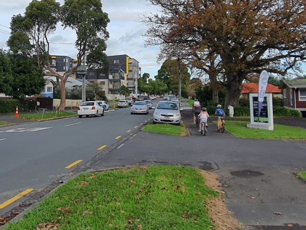
A family attempting to cycle safely along St Georges Road. Photo – Jessica Rose
Right now, the road is unsafe to cross because of cars barrelling down the wide, straight street at high speed. It’s difficult to see beyond the cars parked at the berms on both sides. Although the shared New Lynn to Avondale path will be near, it only overlaps with St Georges Road for a short section. There will not be a safe way to access it from north of the New KO development or south of the train crossing. From the middle of St Georges Road, it is an 850m walk to the nearest bus stop, and just shy of 1km to get to the train station. If that wasn’t enough, car crashes occur with frightening regularity on this stretch during school drop-off. How can we expect a local community to adopt low-carbon modes when they are being inconvenienced instead of incentivised?
St Georges Road and the urban area around it has been earmarked for density because of its proximity to trains, buses, bike paths and amenity. But the connections to those amenities aren’t fit for much other than driving a car on. Creating a bigger-picture plan is out of scope for the agencies working in the area, so no-one really knows what the picture is going to end up looking like.

Is it? Source: Vulture
How can we make it better?
St Georges Road already has everything it needs to be a delightful Healthy Street. There is a stretch where the overhead lines have been undergrounded and indeed the trees are flourishing. The corridor is wide: there’s room for micro-mobility to have its own space, and traffic could be slowed by narrowing the lanes. Buses do not travel this stretch so there would be no hazard for them if a raised table crossing or two were added for people to use. An Innovating Streets pilot would be a fast and easy way to test these changes.
In a sense, a kind of trial has happened. Auckland Transport and Kainga Ora coordinated to organise a concession for the construction workers’ vehicles causing road hazards and destroying the landscape, so that no one would get ticketed. It seems like a missed opportunity: what if, instead of exemptions, they’d provided a lock-up for workers’ gear and a pre-loaded HOP Card to get to site?
Road renewals, stuck in like-for-like
It is a street like this that was depicted in the Auckland Transport’s recent RLTP consultation when inviting feedback on the road renewals budget. However when I asked, in my capacity as a local board member, if this was what Auckland residents were likely to see in road renewals in practice, I was actually laughed at. That kind of transformation would be well out of reach cost-wise for Auckland Transport to fund alone, there are rules around locking renewals in like for like, and maintenance contracts that depend on this.
Nevertheless I did put this to Auckland Transport’s board, and asked them if we could roll the corridor improvements and road renewals into one bucket, so that all roads be considered for mode shift incentives at time of renewal.
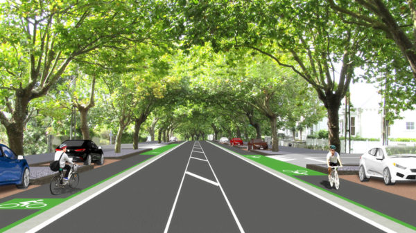
A render of Franklin Road before the cycle lanes were built. Source: Auckland Transport
Without that possibility, when St Georges Road comes up for renewal, it will already be locked into another decade of being car-dominated. Any change in road space allocation is not within the scope of a renewal project. But surely it doesn’t make sense to replace a road like-for-like when its population is set to change so dramatically. Remember – 121 new homes are replacing 11 existing, and with THAB zoning all the way up, that’s just the start.
Joining up the thinking
It’s not that there aren’t great ideas in our governing entities. But they’re too often happening in competition when they could be happening collaboratively. The Kainga Ora housing on St George’s Road and the Panuku Development in Avondale are obvious complementary projects. They’ve both had great masterplanning done. So where’s the planning to reorganise the car-filled space between them?

 Processing...
NZ has a real problem with poor governance at a systemic level which worries me – because it may mean the housing crisis, climate change, poverty and poor productivity are unfixable problems.
I have tried to write about it here – it is a bit long form – but some of it is a 2007 letter from Michael Cullen.
https://brendon-harre.medium.com/new-zealands-rack-rent-housing-crisis-where-to-now-405b63c0281a
There were previously 12, not 4, dwellings at KO’s land at St Georges Road. Also, about half of the land was an underutilised reserve that was sold to KO from Panuku. Still an impressive increase in density though!
I see what you’re saying, it’s 10 dwellings as per google maps, I had only been counting the 4 inside the road loop, which isn’t right.
So 10-12 baseline for dwellings, over 6 road frontages (98 sitting behind 100).
Please accept my apologies, I didn’t do this on purpose. As recognised, it’s a big enough ratio increase without embellishment needed.
The density is too high. 5/6 storeys in that sort of suburban context is jarring, and lacks human scale.
At 4 storeys you can get very good levels of density at a more intimate and human scale level of development.
International research shows the biggest jump in support from increased density for public transit comes from low density suburbia to 3/4 storey terraces and walk up apartments.
At the same time, the economics work better for 6 than 4 stories as you have to have 1/2 elevators for either right?
Somewhat true, although the ‘problems’ of 4 storeys are exaggerated in my opinion. But yes 3 storeys is probably optimal. On a bigger site a mix of 3 and 5/6 storeys can work, you can internalise the impacts of the taller buildings.
When you say “the economics work better” I would ask “economic for whom”? In my experience homes hit the market at the price the market will bear, regardless of build cost. Many cities more affordable than those in Australasia feature 3 to 4 story housing that has a good quality of life. Developers will always demand more, but should be ignored in the public interest.
The public’s interest is to have more housing, not less. Allowing 6 levels instead of 4 enables more housing.
Allowing 6 levels to improve economics may also be the difference between the price the market will bear actually being high enough to cover costs.
The housing crisis was largely caused by deliberately restricting the market to only just allow enough feasible capacity to accommodate population growth which meant that new houses were at a premium. It is in the public interest for the public to be genuinely unsure whether the market will soon be oversaturated with ne homes.
It’s only jarring because the current context is suburban. In 5 years time the context will be that of an urban centre. The buildings are designed for the context that they will sit in for most of their life. 5-6 levels is still very human scaled.
That’s a great point. Everything that changes the landscape seems out of place at first and after a while isn’t noticed any more.
Aside from everything else, I’m continually surprised AT doesn’t take advantage of biking in order to boost their ridership.
Bike parking at stations is a far more dense use of space and therefore cheaper, than car park and ride. Do they not see the absolutely wild success and growth of this solution overseas? I would understand if they were just a train / bus authority, and couldn’t control other infrastructure, but AT also control the roads and their layout!! A major boost in ridership is slapping them in the face. It’s almost like they don’t want more rail ridership.
I agree with this. I’m not sure why one car park, every so many 100 meters or streets, or at all train stations, doesn’t have a cycle hangar installed like you can order in the UK.
“You can use a cycle hangar – a safe, covered place to park your cycle. There are over 7,200 spaces across 25 London boroughs. If you’d like a cycle hangar near your home, you can apply for one through your local council.”
https://tfl.gov.uk/modes/cycling/cycle-parking
I think this is one of the most important elements of your excellent piece -that things are just not linked together. We have a Kainga Ora redevelopment going in our street in Te Atatu -Council consent says they must provide 21 carparks for the 21 units and ONE bike park.
This is what is my primary concern too. Lots of agencies are doing good things, but not together.
They certainly say they’re doing it together, but the reality is that everyone is tied to their property boundary and what’s happening inside it – not the grey areas of overlap or bigger picture. I get frustrated at feeling like a crazy person when I suggest the connected thinking.
It is terribly important to keep in mind that Kainga Ora is tasked with building communities not just houses, and that they have the lions share of the funding. So collaboration from them on projects external to the new builds, is crucial.
Probably a bit off topic but was thinking about why the cycleway and bus lanes on Lambie drive didn’t attract the sort of pushback that other cycleways and bus lanes have. Firstly all business have off street parking secondly not many houses. In addition there was already a bus priority lane at the intersection of Lambie drive and Cavendish road. There are plastic speed bumps bolted onto all driveways where they intersect the footpaths. The cycle way is protected by concrete barriers and ramps have being installed at the bus stops. The buses stop in the bus lane so at the edge of the bike lane with bikes being diverted behind embarking or alighting passengers. So it wouldn’t work so well if it was a transit lane. This is part of the Manukau to Airport bus route.
Probably because it was only ever one lane of traffic each way, few houses, and they complain a bit less or don’t take time to complain as much in South auckland.
Its on my way to work, but the problem is it is just that road. A lonely safe cycle lane that doesn’t join any others.
Also it was probably wider than most roads. I am hoping Puhinui road will be redone to a similar standard. That would connect it up a bit.
Thanks, Jessica. Great post.
I’m super curious about the AT staff member laughing at you for asking if the image they chose to illustrate their programme was representative of the programme.
Do we take from that that we should expect any image used in AT communications could be a piece of decoration rather than an illustration of concepts?
That image of being laughed at is really disturbing. If this is the level of psychological safety they provide (when people make suggestions or challenges), no wonder they are unable to enact change. The management should be ashamed.
+1000. And the arrogance of we know best, business as usual.
I wonder if the industrial process energy includes the steel mill at Glenbrook. Obviously it would include the glass factory. It would be good see some kind of a breakdown to see where the real hard tasks are.
Don’t worry too much about it, with all the in-fill housing and extra density there will be so many cars that people won’t be able to drive anyway. They will be forced to make a choice between sitting in their car, or active/public transport to their destination.
Paul,this is market forces at work,when driving truly becomes a nightmare,commuters will seek other options. It’s an indictment on transport official’s if this is the plan.
Yeah except if you don’t plan and offer, cheaper better and healthier alternatives people won’t do either and will just leave Auckland and porobably NZ citing traffic and rubbish Public Transport. So yes, market forces driving NZ further and further behind.
Which is my concern – needing a balance of carrot and stick, not just sticks. It doesn’t have to cost a lot either. I often think of Sunderland Road off Carrington, where the little bike image with arrows could be painted on, just signalling that the road is to ‘share with care’. Low cost, but a visual reminder that the major cycleway shares this stretch.
Bearing in mind that in the 3 years I was on the Albert Eden Local Board, we tried to get a bike path up one side of that street and were not able to due to cost and road surface type. I would be just as happy with some other interventions like share with care, or that road being a 30km limit with a big 30 and the bike image painted on it. Surely that wouldn’t be too expensive to do?
I don’t like being a negative nancy about it, but it makes you tired when some things seem obvious and are not explained if they are not.
When driving truly becomes terrible it will drag down other alternatives with it. Buses get more stuck, even cyclists will get stuck. Walking becomes ever more dangerous as smaller and smaller streets start taking on through traffic.
I struggle to see what other plan they could possibly have. If I look at areas near me, Glenfield Road is supposed to be both a major bus route and cycling route. I have never heard about any plan to make this actually happen. What layout would they use? A recent renewal of a part of it was like-for-like.
We’re already living your first prediction in Glen Eden: morning traffic at Kelston queues all the way back to the rail bridge almost, and packs so tightly you can’t even get a bike past with a foot on the kerb and wheels in the gutter.
No, a free market approach would be to privatize the roads. Right now we have an limited resource that is not priced – no wonder it is over used and people not paying for it.
I guess this all comes down to leadership,like water,employees seek the path of least resistance.Too much water channeled into the wrong place,causes immense damage.Urban councils are probably sitting back,thanking their lucky stars ,that recent flooding damage in rural areas hasn’t, happened to them. However a organization/council well lead ,would be pulling his/her team together ,and using the flooding examples as a clear demonstration,of what happens ,when too much of a resource/commodity/ gets it’s own way.
This was a really interesting article, thank you! Takaanini town centre is another recent one where planning has dismally failed to provide a network for anything except cars.
The new library has lovely cycle parking, but the painted cycle lanes stop several hundred metres short. It’s not very far from the train station (with a recently built park-and-ride) and several schools, but it’s simply not safe to ride there because of the on-street parking for the Addison development. I suspect the car problems in this area won’t be considered when they close the nearby level crossings – AT simply must stop pandering to drivers and luddite councillors, but I don’t think they have the courage to do so.
I think this is partly a super city issue; there is no one looking at small changes and fixes to local communities, the local boards have no budget or say, AT only cares about mega projects. There was a picture on Friday of a sign for the borough of Mt Roskill’s best kept street: I think it would be nice if we still had the borough concept or similar with adequate funding responsible for local roads, town centres, etc while the super city handles the city wide type projects like rubbish, water, arterial roads, PT, etc. The boroughs could compete for liveability.
Hear hear.
Its a balance as with anything.
Now as much as ever we need joined up projects. Things that never would have happened if it were a couple dozen little organizations where if one objects they get to not spend any money on it while benefiting. Or just torpedoing every large project ever.
But the cost benefit ratio of these little improvements is quite often absolutely through the roof and make big improvements in peoples lives.
Sometimes I think that having a cycle is the way to go. EG for a decade or 2 there is a large central council solving the big systemic issues, projects like CRL, busways, central interceptor etc. And then for the decade or 2 after that there are the little organizations, providing this little stuff, walking path through a park, a bike lane here, bike parking etc.
Hypothecation of a % of parking revenue should go to Local Boards. LB’s could then use this to help fund local projects and give residents a sense that their parking fees are contributing to their own community. A win/win. AT is no where near delivering on its Parking Policy, as everytime they talk about parking charges LB’s and Business Associations lose their minds.
Does that run the risk of making parking something they can’t give up to better uses, though?
Interesting post, albeit entirely unsurprising. Due to this, the opinion that people should change their habits is simply indefensible. What are they going to do?
Live in an apartment, centrally? Congratulations, you’re now part of an underclass. Try walking from Victoria Park to Meyers park. Note that there were already apartments in this area 20 years ago.
Ride a bicycle to work? Congratulations, you’re now part of an underclass. AT can’t be bothered to do even basic measures to keep you alive. Wait — that is not entirely true. They can, but sledgehammers or forklifts will happen and they’ll have to back off.
Take public transport? Congratulations, etc. etc. Half of the time your bus stop will be on the wrong side of some big arterial. Good luck crossing it. Also I hope you have bus lanes in your area, or else.
So I’m not sure what to think about it. Shutting up about it won’t help anyone. But not shutting up boils down to telling people they should join an underclass of choice, which is counterproductive. You can try it yourself but as the article points out the street design around you will basically force your hand. Complaining to the council, well it looks like the councillors don’t have much say about it either.
I’m curious what the developers think of this. If you’re selling apartments AT is basically shitting on your front yard.
totally agree. probably nothing will change in the next 10 years unfortunately
Maybe fortunately. Moving faster would be an act of coercion.
Well, maybe in this context it is right that Grey Lynn, St Mary’s bay, and Remuera are held from development. I don’t think 5M+ Remuera Apartments, 3M+ Jervois road apartments can be defined as something underclass. Probably such a shortage and cost in the nearest suburbs can draw an attractive picture of city-fringe apartments living for those who care about classes.
No it is not.
The resistance to any form of intensification is likely partially because of how the council treats the apartments nearby. You did that walk, right? Why can’t they maintain the footpaths like they do in the surrounding suburbs? There is no reason, ever, to leave the streets between those apartments as they are now.
And the other thing of course is that for many people the housing crisis is a feature not a bug. 3 million to stay away from “the wrong element”. Let’s manage housing like a currency, so what if this makes 100,000 people homeless? Let’s call it “heritage”.
(Obviously if you can drop 3 million on any kind of home you’ll be fine)
The streets and blocks in Grey Lynn are perfectly sized for 5 storey apartments. Ponsonby will be fine too if we cut a few lanes through those long blocks. It just looks like the council is hopelessly out of its depth when it comes to dealing with it.
By the way there are still two sections available at Vinegar lane. A bigger corner one and a smaller 88m one priced at 1.2m.
So there’s currently a place for apartments in Grey Lynn and some more blocks are currently building. And indeed most of these are completely unaffordable for 99% of population.
Your point?
My point that at this stage it is probably preliminary to rezone most of nearest suburbs for terraced/apartments. There’s not much good experience of building apartments in New Zealand, and doing it quickly in for example in Grey Lynn could be a disaster. CBD is a disaster, Eden terrace is rubbish, Newmarket is not much better, Wynyard and Viaduct are also questionable. why should all this be expanded to other areas before proper expertise and practices evolved?
The Vinegar lane is a great experiment, but apparently it’s still not complete and demand didn’t consume all the lots.
Perfect is the enemy of good; holding back the most suitable development sites until we’ve ‘perfected’ quality apartment construction is silly. It means apartments don’t get built at all, or they get built in odd places, where the demand is weaker and it’s more speculative, resulting in lower densities and inconsistent built outcomes.
We get better at doing things with practice. Build more apartments, and you upskill the builders, the architects, the developers, the buyers. This is happening anyway, in the private sector and with Kāinga Ora, and it will speed up if we remove some of the restrictions on apartments.
I’m going to quote your other post — “most of great old cities evolved”. Allowing this process is exactly why zoning laws should be loosened up by a lot, over wide areas.
Much of the disaster is because we have stopped this process for so long. Normally in these central areas those old villas would have gradually been replaced by 2 storey townhouses, then 3 storey, then 4. Add low rise apartments. We would have gradually figured out what works and what doesn’t.
It would look messy but that is what happens if you let a city evolve.
As for Vinager Lane, if they wanted they could easily have sold everything for a lower price. If you only have a few dozen of such lots in all of Central Auckland of course it is better to be patient for some particularly rich buyer to come along.
Roeland, I’m not really arguing with you, because I have no point to completely disagree with you. The area was screwed up with zoning for decades and I think one year later or one year sooner won’t make a big difference now.
I recently had a walk in Te-Atatu South and Te-Atatu Peninsula, they both all buzzing with excitement about their new zoning:
https://youtu.be/34ItqjuV_P4
https://youtu.be/r81qH1w5vMg
Houses cleaned, houses demolished a lot of townhouses are being built at a moment. Looks totally different from what I’ve seen five-six years ago.
Thanks for the post, Jessica. I’d note that table crossings are not “hazardous” for buses unless their drivers refuse to slow down for them.
“The locals are asking for more car parking. Can you blame them?” Just wait until all the minimum parking rules are pulled out of the Unitary Plan. At that point parking will revert to being a Council responsibility like it was before the Town and Country Planning Act. Every local board can expect demands for parking areas to be built from the public purse.
Miffy, the great news is that car parking isn’t actually a requirement. No one has to provide it. We could just end up with people choosing the amount of car parking that works for them instead of being forced to subsidise your lifestyle choices.
In reality we will just end up with cars parked all over the place. Just like in other places that don’t require it. Changing the requirement doesnt magically change the need for a car to survive.
Just googled some pictures of land near post-soviet commie blocks. That is Auckland’s future with intensification:
https://i.redd.it/v00b4gl160y21.jpg
https://varlamov.me/2015/-/mosdvor.jpg
https://varlamov.me/2015/-/6e3bb6de99313e7a5aaf225cbff.jpg
Unlikely but density can be done right.
Lots of trees, parks, public transport, good bike lanes and sidewalks.
https://www.google.co.nz/maps/@37.3880433,126.952615,465m/data=!3m1!1e3?hl=en-GB&authuser=0
https://www.google.co.nz/maps/@37.3767042,126.9728233,569m/data=!3m1!1e3?hl=en-GB&authuser=0
https://www.google.co.nz/maps/@37.3767042,126.9728233,569m/data=!3m1!1e3?hl=en-GB&authuser=0
https://www.google.co.nz/maps/@37.3767042,126.9728233,569m/data=!3m1!1e3?hl=en-GB&authuser=0
oops
https://www.google.co.nz/maps/@50.8188255,4.3362821,1207m/data=!3m1!1e3?hl=en-GB&authuser=0
Bob – I agree, the integration to all the things that make Tamaki Makaurau a lovely city, ie the character of being close to sea and nature. Having bio corridors and natural environment as well as dense living is at this city’s fingertips as the place renews at such scale. Its the only time in the next 50 years to build back using all the knowledge of what makes a city great.
Yeah, many places in Seoul look really Soviet. I was a bit scared when I first visited Seoul for a first time. Luckily Auckland is really far from Seoul’s 9m population.
Next time I decided to stay on the Yeongjongdo island (one where the Incheon airport located) and discovered it by foot, looks a lot better than 20floor madness: https://goo.gl/maps/PJPXKZcSzSfhp631A
https://goo.gl/maps/vfPQ3shbSoFGyGyh8
I believe there are limits when density is no longer good.
You missed my point. Lots of parts of Seoul have been done right esp Gyeonggido and i really miss it, it is mainly the older bits that look ghettoish. Being close to parks and mountains, yet at the same time walkable to public transport and shops. Spent nearly 5 years there and didn’t drive a car once and never needed to, yet i was able to get out hiking way easier than I can here. All the main roads had wide footpaths along side as did rivers and parks. All the main roads had over bridges/under passes or green pedestrian lights that went green on touch.
* this is Aucklands future without changing some transport infrastructure.
Avondale is a thoroughfare for a lot of traffic, and its not just St Georges that needs sorting out. Bypassing the main st, redeveloping the racecourse land and sorting out the St Jude St level crossing are all very big problems, all while providing interconnection between Gt Nth Rd to the east & west, New North Rd, the Tiverton/Wolverton corridor, Ash St and Rosebank Rd.
To sort it out:
-Connect Rosebank Rd to Gt Nth Rd across the east end of the racecourse, and restrict access on the existing portion of Rosebank Rd through the town centre.
-Tunnel from New North Rd under Blockhouse Bay Rd, the railway line and connect to Gt Nth Rd on the west side of the roundabout
The racecourse is a private property, so it’s unlikely to be developed into something good like a park. It will probably become a shopping centre or something.
I call this ‘the elephant in the room’; anyone can make some pretty easy guesses to what is likely to happen in a big green field in a THAB zone, if it ever became available. Kindly providing an urban forest park that was a safe haven for biodiversity in the dense urban surrounds. That offered a heat sink, and place for people to connect with the natural world, exercise outdoors, listen to birdsong, is not usually the obvious earner.
On saying that a lot can change in 5 years, so if the climate comes crashing down sooner, we might see some value also put into the various supporting systems infra that create a thriving community. I stay hopeful.
Great post Jessica, this joined up thinking is sorely needed.
This is such a good read, thank you! I really hope it makes its way to the executive teams and boards of every organisation you identify. Also, “exquisite corpse” is such an exquisitely accurate metaphor for the often deadly outcomes of carefully ticking one’s own particular boxes while failing to connect with the others.
With so much of the budget locked up in road renewals for the foreseeable future, you’re right that this should be one of the biggest levers for change. If every single road renewal went even some way towards creating a fit-for-purpose, climate-friendly, Vision Zero healthy street, that’d be a start.
A couple of years ago, AT’s CEO promised this would be looked at when the contracts next rolled over – which happens to be this year. (More on that here: https://www.greaterauckland.org.nz/2021/03/10/gold-in-them-there-road-renewals/ )
So, we *should* start seeing integrated improvements soon, on any road renewals in Central and South Auckland… watch this space I guess.
Other than that, what else can help budge this system? Monthly or weekly fare-free-days, so more people can explore and experience how public transport works? More funding for forward-thinking Local Boards to deliver tactical projects, ‘cos they know where the gaps are that need filling? All the heads of the relevant orgs in one room with a bunch of markers, a giant map of the city, and a race against the climate clock?
Yes I know – and that was an excellent article on it. However the responses I got from the inquiry to this RLTP sound like that message has not filtered through. It’s the same with Healthy Streets framework being adopted and then not much coming of that.
I asked AT CEO at the healthy streets auckland conversation, after the event, about the road renewals approach at that time. I had just been elected to the Alert Eden Local Board and had just learned about the renewals process. I couldn’t understand it, why would you just do the same thing over and over?? It took another 2 years to learn about the maintenance contracts system.
It’s not all ATs fault, they could do with funding to support the city density that they need to cater to. But seeing that all of the associated organisations are pretty risk adverse to change, there is no clear one that can offer leadership in this space. We’ve all seen what happens to teams and people who stick their heads over the parapet. Straight off the top of my head I can name 3 high profile public service biz that have axed tall poppies recently.
I ride from New Lynn through to Waterview path to the City. I can’t wait for the New Lynn Avondale path to be completed. The road works on Wolverton st are incredibly dangerous for cycling as no one drives at the 30 limit and there is very little space. I usually ride on the footpath through here. Blockhouse bay road isn’t great either.
St Georges road is crap now for cycling, cars berm parked on both sides, and that Avondale roundabout, my god what a mess. There is a kids playground and learn to cycle course across from the shops, but good luck getting there safely on a bike.
Something really needs to change with how AT does things if a big Kainga Ora development can’t trigger a street transformation. There are apartments going in at the north side of Avondale too. Maybe the racecourse itself could just become one large carpark!
agreed. Avondale area is a mess at the moment and no one seem to care from the board/council or AT
I’m a St Georges Rd resident and the lack of safe travel options leaves us reliant on cars. Since there’s no bus service along our road and it isn’t safe to walk here at night, any evening outing or late day at work means driving.
Improving transport options is the answer to getting people out of their cars. Removing carparks merely makes life harder for those who need to use them.
I’m looking forward to the new cycle path, but will still need a car, unless a bus route is added here.
exactly, and so many streets have the same problem. sometimes there is a bus stop on the next street but it goes only to city centre and thats about it.