We hear a lot about the great cycling conditions in Amsterdam, for obvious reasons. When I spent a few months there in 2019, I found myself looking at the urban form around that bike lanes and found that the streets and buildings play their part in creating the city’s famous bike-friendly conditions.
In most of inner Amsterdam, people live in 4-6 storey brick apartment buildings. Different neighbourhoods and suburbs have unique versions of this medium density typology because the city has grown through several waves of development in the last two centuries.
The ‘case study’ in this post is in the Oud-West neighbourhood, about 10 minute’s ride from the city centre. What I liked about this neighbourhood was how intimate and human it felt, while still being very connected to the rest of Amsterdam.
The Kalff Plan
The Oud-West came out of the The Kalff Plan, an expansion plan put forward in 1877 by Jan Kalff, the then-director of Public Works. The Plan proposed a new residential belt around the perimeter of the existing city. It is characterised by layouts that followed existing landscape, infrastructure and urban patterns. The Kalff Plan is one of a series of planned expansions to Amsterdam as the city grew over the 19th and 20th centuries. The buildings in Oud-West date from the late 19th /early 20th century and their art-nouveau detailing adds to the neighbourhood’s style and texture. These days, the Oud-West is well on the way towards being gentrified, because it’s a lovely part of the city to live in – close to Vondelpark, close to the centre, but off the most beaten of the tourist tracks.

The Kalff Plan. The area proposed for development was the ring of red residential blocks surrounding the old city centre.
The block
Let’s dive into one intersection: where the streets Tweede Helmerstraat and Alberdingk Thijmstraat (don’t ask me to say those out loud) meet. The intersection sits within a cluster of short blocks (each about 100mx50m) that are bounded by arterial routes, secondary connectors, and canals. It’s highlighted with a yellow circle in the diagram below.
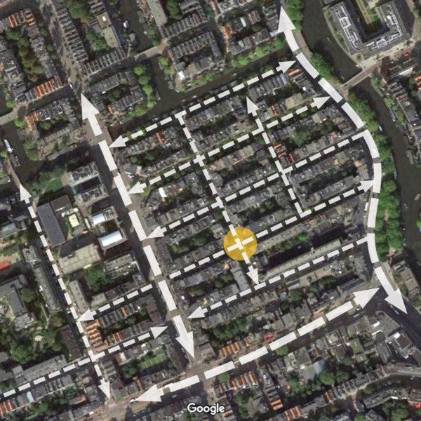
Small blocks, a clear heirarchy, a tighter grain for bikes and pedestrians than for cars, and… canals!
The arterial routes have total mode seperation, with a cross section best described as: pedestrian/bike/traffic/tram/tram/car/bike/pedestrian. The internal residential streets are shared, and are mostly one-way for cars.
Shops, cafes and other businesses line the ground floor of the arterial route to the west and the one to the south, and business store-fronts are dotted throughout the neighbourhood, usually at the corners. These were useful as landmarks and added to the diversity of activities within the area.
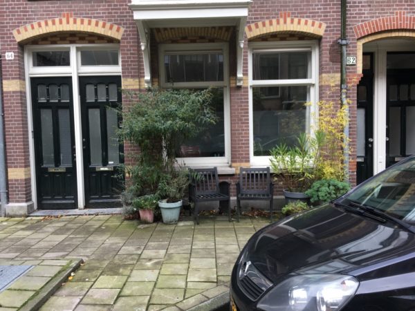
The intersection
Where Tweede Helmerstraat and Alberdingk Thijmstraat meet, the entire intersection is a big raised table flush with the footpath around it. The arms of the raised table extend about two metres into each street. Within the footpath, each corner is populated with trees and street furniture, including clusters of bike racks, and planter boxes.
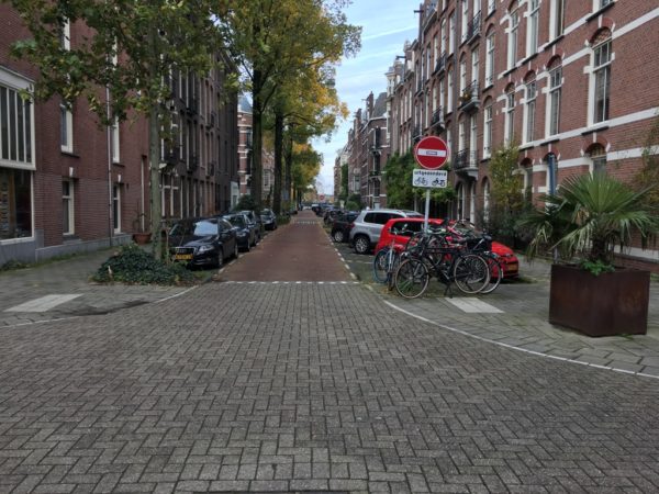
View from the middle of the raised table, taken safely due to lack of cars driving about. There’s also a lot of brick.
Both streets have the same asymmetrical cross-section formed by the car parking layout:
- On the south or east side, angled car parks with occasional buildouts for bike racks.
- On the north or west side, parallel carparks with a build-out and tall tree for every three car parks.
Regular build-outs are multi-functional.
The streets’ asymmetrical cross-sections are important, because on the southern part of Alberdingk Thijmstraat, the width given to angled car parking has been allocated instead to a small playground running the length of the block. The playground is actually slightly wider than the strip of angled parks, so the street has been offset to allow for it, and there’s no parallel parking opposite it.

The playground cleverly uses as much space as it can within the block’s geometry.
This playground is a very compact, clever use of space. The designers have used all the space available and created:
- A rubber-surfaced terrain with climbing equipment embedded into it, so the whole surface is about play
- a low wall all along one side provides a place for parents to sit
- A tiny hard court with steel soccer goals
- A bulk bike parking area which also allows clear access to the supermarket
- And a footpath running the length of it, between the playground and the buildings.
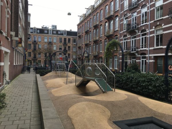
There’s a lot of play in this small space.
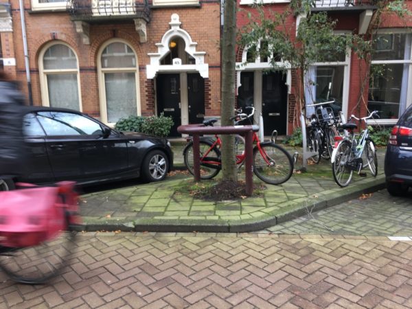
The playground is the only dedicated public recreation space within this cluster of blocks (the nearest park, Vondelpark, is a 7-minute walk away), but I saw plenty of informal amenity and evidence that people are making public outdoor spaces their own. In Amsterdam you often see narrow garden beds built into the footpaths in front of buildings, which residents plant and maintain themselves. This means that there’s a huge variety of green as you walk down the street, from weedy messes, to beautiful herbaceaous borders, to 2-storey-high climbers ascending to a balcony above.
The characteristic Dutch ‘Stoep’, DIY street activation.
These little pockets of green become shared ‘front yard’ space. Even at the beginning of winter there are signs that people happily claim space on the street: pot plants, collections of old chairs and entire picnic tables are found arranged on the footpath.
You do feel surrounded by people all the time: the sound of neighbours heading up and down creaky and narrow Amsterdam stairs, buzzers ringing, people crossing the floor above you, the washing machine in the apartment next door, glimpses of people in the windows of houses across the street. People are conscious of their effect on their neighbours, and there’s an unspoken agreement to be mindful of each other’s presence in their lives.

Did I mention, bike-friendly?
I enjoyed the sense of being tucked away in a calm, connected, neighbourly world – experiencing the quiet slowness of the streets, the ease of moving around by bike and on foot, all the clues to the presence and human-ness of all the other residents, and the playground as a small focus of activity in amongst it all. Although you can see from the photos that it’s not a car-free neighbourhood, the tight road cross-sections, the one-way system, and the human scale of all of its parts made it feel like a low-traffic neighbourhood.
I think that this corner of the Oud-West is a compelling example of how the classic ‘best practice’ urban residential design elements work when you get them right and put them all together. The majestic trees and art-nouveau flourishes do their bit. But it also seems that if you stripped it back, all we find is good geometry with room for the community to get on with inhabiting the space in the way they want to.
A post-covid epilogue
This post comes from time spent in Amsterdam at the end of 2019, just before COVID-19 wreaked havoc on the Netherlands and the rest of the world. I wanted to know what had changed in the last 14 months so I contacted a friend who’s still there. The first thing she said was that everyone’s enjoying how nice it is without the city’s usual tourist hoardes. The second thing she talked about was ‘the terraces’, a name used for a new kind of pop-up space on the street. The Council has allowed cafes, bars and restaurants to extend their outdoor eating spaces onto the street, to allow for social distancing. Although this often involves spreading into two or three car parking spaces, there’s been little pushback. Amsterdam’s residents are – anecdotally, at least – in favour of the terraces. People like having fewer cars on the street, and enjoy the atmosphere the terraces have created.
The Council briefly experimented with widening the footpaths on certain main roads by pushing cyclists out of their cycle lanes and into the street to slum it with the cars. This, however, did not go down well and was soon abandoned. Bikes are still top of the food chain in Amsterdam.

 Processing...
It would be great if we were building this density and style of building somewhere in suburban Auckland (but not as far out as Hobsonville). I always find it funny that NZers look at that and think it is awful / slum / etc, to me it looks a lot nicer and more livable than most of suburban NZ (could be even better with more trees and colour and some sun). The other great thing about density is that there is more rates collected in a smaller area to pay for nice streetscapes, maintenance, parks, etc.
The angle parking is an interesting one. I wonder if it would work better on our residential streets to have one side of angle parking compared to two sides of parallel; maybe giving a similar number of parks but with more available road space? To me it just looks better somehow.
+1
On angle parking: Its a very efficient use of space when you can have a continuous run of angle parks like they do. The problem with residential NZ streets is all the driveways prevent getting continuous runs like that.
The every-property-has-a-driveway norm is one of the barriers to moving towards a perimeter housing model. Either the whole block relies on one or two shared driveways to access off-street parking (hard to achieve incrementally, requires whole-of-block coordination) or every new dwelling relies on on-street parking (socialises some of the cost of car ownership, doesn’t scale well across a neighbourhood) or goes car-free (still needs significant infrastructure investment until this is practical in most parts of the city).
“On the north or west side, parallel carparks with a build-out and tall tree for every three car parks.”
Seems to me driveways wouldn’t be that big an issue in many residential areas after all.
You need to remove three angle car parks to accommodate a driveway.
“You need to remove three angle car parks to accommodate a driveway.”
My property is wide enough you could have more than 3 angle parks between my driveway and the neighbours. Just don’t have the trees and where the trees are in the Dutch example we can have driveways. You would still fit heaps of carparks down most residential roads and have space for cyclists on the other side of the road.
Roads that are busy and fast enough to justify separated cycling infrastructure are too busy and fast to safely accommodate angle parking. This layout would only be useful in town centres with low speed limits.
I had a quick look out on my street, fairly common in New Zealand. You might get 10 angle car parks over about 1km. There are probably close to 100 parallel car parks in the space as it stands. Our existing residential streets would be much better with the existing parallel car parking formalised into recessed car parking and a lot of them made one way or no through way for general traffic.
Sailor Boy you are suggesting one angle car park every 100 metres of road. That is so laughable I really don’t see how I can have a proper discussion of options with someone who has pulled numbers out of thin air.
The important bit here is that in Amsterdam, car owne ship is ultra low. Many people have a licence but cannot drive.
Within the ring road, it can take years to get a licence for a parking spot.
A little more space is reserved for cars in more distant neighbourhoods.
On street parking works because 1 in 5 household has a car.
It’s being discussed to ban them from the hypercentre, as rich people living on historical canals like to park their oversized SUV.
The green government of Amsterdam is cracking down…
Wow! This is really ugly and claustrophobic! Look at the pedestrian path width and absence of a berm. Do you call it pedestrian friendly? I simply won’t be able to walk at my normal pace without colliding into somebody.
Perhaps you could walk in the car lane if your pace is such that it does not allow for other body avoidance?
I guess you’d have to be there to get it. It’s an incredibly cozy and welcoming space and looking at the photos of this post brings back all sorts of wonderful feelings from my time walking the streets of Amsterdam.
These are tiny residential streets so there won’t be as many people to bump into. On the larger streets you have a lot more space to walk but then you don’t have to walk nearly as far for anything so your pace can adjust for that. I’m one of the fastest walkers I’ve ever met and I had no problems in Amsterdam.
I ran through this neighourhood while I was in Amsterdam. If you want to walk fast or run, you go on the roadway. The traffic is so sparse and so slow that it works really well.
Andrew, the pavements may look narrow, but typically they are not – perfectly adequate size for many people to walk along. Got to remember that (pre-Covid) Amsterdam had about 20 million tourists per year (for a city population of about one million) and these people all fitted on the pavements. In the Red Light zone, then yes, there is lots of bumping into people. But that’s only a few downtown streets – most of the time you can walk happily around the city with no issues. No need for berms. No need for cars. Great tram service, great biking city. No need to go jogging either (that peculiar Auckland habit) as most people are already quite fit from biking everywhere.
Matthew Occidental, Lewis, there are streets of similar scale in Auckland: Vinegar Lane and High Street, I don’t say they are fundamentally wrong, but I prefer to avoid them.
These Amsterdam streets do really look like a 19th century design, and they actually are. There’s no reason to build like this in 21 century, because lift was invented quite a while ago. Plans like these won’t ever pass sanitary and insolation assessments in many cities with a magnitude higher population than Amsterdam. Buildings here are apartment blocks, so it won’t matter if they will get a bit taller to make streets a bit wider without decreasing population density.
The only reason they look somewhat attractive is that because they are reasonably well decorated and well-maintained. Remove décor and add some dirt and they will really look like soviet Khrushchyovkas, soviet uglies at least have more green space between them.
Yet High St is popular with many people. And Vinegar Lane would probably work if Auckland had parking enforcement.
Why knock what Amsterdam has, when it clearly works?
I suspect the streets and buildings are reasonably well decorated and well-maintained because they are human scale so people wish to keep them decorated and maintained. Wider streets and taller buildings can achieve that too. Sometimes they don’t due to the scale being too big. But the devil is in the details.
And a lot of that detail is about how much the cars dominate, which has many contributing factors, including the built environment. Clearly in Amsterdam, this built form works with a far superior transport system than we have. Again, it’s about details. These buildings co-existed with a car-dominated for a couple of decades but the kinds of details Marita has pointed out have contributed to the systems change they’ve experienced.
Well, that’s good that some people like it, and even better that we have different interests with them. Bars, vape saloons and other nonsense: that’s the true amenities the population density gives you.
Well, there are Jason books and Union books… But vapes and bars are lot more numerous.
What’s your beef, Andrew? City life been hard on you?
Wishing you well, mate. People have good in them.
Well there are plenty of low density places you could call home, Andrew. Auckland is New Zealand’s largest city and needs more amenities in close proximity to residences, to enable us to live more locally. An increase in population density provides this.
Amsterdam’s population density (meaning shorter distances, more friends and amenities close) and its cycling focus, is a place with freedom for children, teenagers, elderly and for people with different abilities. That’s why they have good emotional and social health outcomes, in addition to the good physical health outcomes.
Heidi, I don’t really want to go into the arguing battle. Just placed my opinion in comments. I believe it’s important to dilute this impression that these Amsterdam streets are so beautiful that everyone would love living there.
I understand that infill, density growth and urban environment change are inevitable as population grows, but I think it can be done better than in Netherlands.
Great post! Thank you Marita. This is where I stayed when I first visited Amsterdam (aged nine) – we stayed in a hotel in Emmastraat. Despite -35°C wind chill from Siberia (this was February) it was a very enjoyable neighbourhood to explore on foot (until I stuck my foot through the ice in a pond in the Vondelpark).
Importantly, this grain, variety and density is apparent in Amsterdam’s newest suburbs too. Go to IJburg (started in the early 2000s) and we see the same narrow plots, connected blocks and civilised streets. Even the on-street car parking is done well as part of the streetscape.
Both the Oud-West and IJburg use every scrap of land, but do so in a way that is attractive and humane. There’s lots to learn from a dense city that maintains a high quality of life.
See Cornelis Zilleslaan for a good example of an IJburg street:
https://www.google.com/maps/@52.3612318,4.9787354,3a,75y,96.18h,91.59t/data=!3m7!1e1!3m5!1so_ftHK_P4gVolJYyD5OXww!2e0!6shttps:%2F%2Fstreetviewpixels-pa.googleapis.com%2Fv1%2Fthumbnail%3Fpanoid%3Do_ftHK_P4gVolJYyD5OXww%26cb_client%3Dmaps_sv.tactile.gps%26w%3D203%26h%3D100%26yaw%3D15.090198%26pitch%3D0%26thumbfov%3D100!7i16384!8i8192
https://goo.gl/maps/iodp51vhtopcRjWd9
This is what this currently looks like in Auckland. Note the key differences:
Two way traffic on a 200m long street, because cars have to be able to go everywhere all the time
0 street trees
Three separate berms
This road is *wider* than the one in Amsterdam. It has less car parking, fewer trees, more paved area. Why are we still designing this!!
I presume it’s also a 50km/hr area. Which influences the design to allow such speeds and makes on road cycling much less safe. wide radius turns, etc
That’s one of the latest things I’m really surprised about. Why are these streets 50km/hr? They’re trying to be local slow streets, but simultaneously have to be designed to accommodate high speed traffic and 4 cars for each house. Fugly and disfunctional.
Because the current “Setting of Speed Limits Rule” sets the default urban speed limit as 50km/h and the default rural speed limit as 100km/h, and makes Councils jump through a bunch of hoops for each road individually (including in some cases having to ask Waka Kotahi’s permission) before they can set anything else.
Hopefully this will be changed in the new 2021 Rule, which proposes allowing speed limit areas that can have any default speed limit.
I too continue to be baffled by residential streets outfitted at great expense with speed bumps, chicanes and neckdowns intended to slow traffic to 15km/h, but a 50km/h posted limit than encourages people to hoon between them.
And if you drive at 49 and hit someone walking or cycling it is bound to be their fault because you were under the stupid meaningless limit.
Just to dilute this happy like-mindedness… For me this Turehu Rd looks a lot better than Amsterdam’s photos above.
There certainly are good points when it comes to the new homes built on Turehu Road and the area in general. But is still a very car centric neighbourhood. So many cars parked on or over footpaths. I don’t see what extra quality of life you would gain by having what looks like 1 one metre gap between houses, that could be extra inside space. Windows looking directly onto a solid wall don’t actually interest me at all, in fact that sounds depressing. Some of the houses have green areas which are being used to store rubbish bins while others have a tree planted in that area so it will be interesting to see how the area matures and ages. Also I can see a playground on Leadership Cres hopefully there are others around the area and not just the one.
The success of this neighbourhood will tell in time when we see how the residents use it. Does it offer a feeling of safety that allows young people to get around independently of their parents transporting them everywhere by car? Does it have safe links to nearby bus stops and train stations so adults are willing to leave their car at home for some of their trips?
The important thing isn’t what the buildings look like but how people interact with the streetscape around where they live and how this affects their transport decisions.
Worth to mention that this is not really equal comparison: Tweede Helmerstraat and Alberdingk Thijmstraat are just 2 – 2.5 Km away from the city. Place the yellow google man at least 12 Km away somewhere in Gaasperdam: https://www.google.com/maps/@52.2910585,4.9792553,3a,90y,331.85h,98.17t/data=!3m6!1e1!3m4!1sblzGp1zTopHWWZz9N6y1rw!2e0!7i16384!8i8192 and the picture will look a lot more familiar. 2.5 Km away from Auckland City is something like Parnell, Newmarket and Eden Terrace, which is also not very low density, and for sure has some one-way streets.
I don’t know if you’re discussing the distance from the city centre appropriately. We’re discussing the built form of new suburbs – buildings and streets. Lower density suburbs like Sailor Boy’s example will create longer distances, yes. That’s to be avoided, too.
“Place the yellow google man at least 12 Km away”
Ok: https://goo.gl/maps/6MYVo4Hg4WpQEJK48
New Zealand design terrible streets. There is literally nothing in the Takanini design that would improve any of the three Dutch examples.
The annoying thing is that, on very rare occasions, we get it spot on in NZ.
There are many interesting things to note in the Dutch example.
The red pavement is a cycle path. The other street allows cars, but this street has to give way to the cycle path.
There are no bike lanes in this area. You have shared streets, a few dedicated bike paths, and just to the north you see a road for cars and buses only, without footpath or bike lane.
Compare the corner radius on intersections.
The parking arrangements are different: in Auckland you have parking on each house while in Gaasperdam you see parking consolidated on a few parking lots. I think the latter arrangement is superior. Parking in each house isolates houses from the street. I am assuming the Dutch have the option to later free up some space by consolidating all those parking lots into a multi-story car park if they want to.
You always find inanely stupid things in Auckland examples. There are 2 roadways on Swamp Kauri Grove. 1 more than needed. You almost certainly don’t need this street to be 2 way.
To add to this,
* The roads in the Dutch example are much narrower still (hence discouraging speed)
* The road is made of cobblestone paving which also discourages higher speeds (but makes it noisier)
* Because the vehicles are parked on the road, it is not necessary to create a dead space separating the road from the pedestrian path
* Pedestrians still need to watch out for cars coming into and out of driveways, while the Dutch pedestrians can really walk without worry
* The NZ homes all have a front porch with a fence. These spaces are not very well used as they are too small and not private enough. The fences also decrease the community feels imo.
*There are raised crossings every couple of hundred meters with narrowed roads to discourage speed
* The space used for narrowing the road is used by a tree which in my opinion is great example of making the most of the provided space.
“Why are we still designing this!!” Because the Council and AT demand it. If you don’t get a cross section included in a plan change then the Council and AT will send along 5 people to a meeting and each person will insist on space for their pet interest. The bus operations person wants 3.5m lanes, the pedestrian person wants 1.8m footpaths on either side, the services person insists on wide berms, the greenie insists on water gardens and a cycle wonk will demand separated cyclepaths. The only person willing to compromise will be the developer who will just make the road wider to accommodate the demands. Oh and then the urban designer will tell you the roads are too wide.
I 100% agree that this is because of council (and NZTA) policies. I guess I want to understand *why* we have those policies.
Each policy makes perfect sense from the perspective of the department that got it implemented, which operates in a silo that is isolated from any other arm of local or central government.
It’s the interaction of the different policies that creates perverse outcomes. No-one with the power to change the policies looks at the combination of them holistically, so no attempts are made at solving the problems created by that interaction.
The only solution I have found is to specify cross sections in the Plan Change itself (which is a weirdly specific rule to include at that stage). But at least that forces the Council and its agencies to have only one opinion. Then at the subdivision stage when they start issuing demands you can just say no. Otherwise they refuse to budge knowing the developer must increase to get a consent due the pressure of holding costs.
The impact of all of this is huge. We are building minor collector roads that are 23m wide cf Dominion Road which carries thousands of people every day which is mostly 20.1m wide.
It was worse when there was a specialist walking and cycling team as they would demand no vehicle crossings on a collector which meant you had to include one more local road just to service lots.
@SB also because we sprawl, the NZ example is 32km from Britomart whereas the new Amsterdam development is 10km from Amsterdam Central. We need to be adding this sort of density on the isthmus, not on the periphery.
FWIW Amsterdam also sprawls, but it does it in a different way. If they sprawl onto new land, they don’t just build another blanket of single house residential zone and call it a day — they build a proper town.
A bit to the east of the Gaasperdam example you will see the town of Almere. This is about 30 km from the city of Amsterdam but you will see the same sort of density there.
This has many advantages. People don’t need to drive this far to things so often. You can have your higher density walkable or bikable areas. You can organise public transport in a sensible way. This being a substantial town by itself is what makes public transport sensible.
It would have been perfectly sensible to build something similar in Silverdale. (just over 30 km from CBD) We already have a northern express.
Almere is really rather good. Compared to any equivalent 1980s British out-of-town suburb, it is utterly superb. It pains me to think of what the UK (and other countries) eschewed in favour of distributor roads, impermeable cul-de-sacs and out-of-town shopping centres.
Almere’s street pattern is human-scaled, the elevated twin-track railway line runs through its centre (with direct links to Amsterdam and Zwolle) and it has bypass roads to the north and south. The central square feels genuinely urban and the landscape (like pretty much anywhere in North Holland) is punctuated with waterways.
While its origins are 1970s, more recent developments include a good variety of plot-based housing to the west, at Almere Poort.
It’s well worth examining Almere on Open Street Map:https://www.openstreetmap.org/search?query=almere%20stad#map=14/52.3722/5.2176
This is a total myth SR. The Netherlands has medium density as shown in this post all over the country, including in ‘suburbs’ of Amsterdam. The issue isn’t that we have suburbs. The issue is that we set policies and make plans that force developers to build low density, single use sprawl with road networks that make driving the only realistic option for most trips. We *chose* our current urban form.
https://www.google.com/maps/@-37.1020802,174.9387632,3a,72y,11.8h,74.6t/data=!3m6!1e1!3m4!1st_d2wmfptgXCwm-3Ot8-jQ!2e0!7i16384!8i8192
If you look at an even newer development, you’ll see they do put trees in now. The houses aren’t even vaguely in the style of Amsterdam of course (not really visible due to out of dateness of Google Maps but you can see them in the distance here: https://imgur.com/a/iXdagYw), but I don’t see why that’d change if they did do narrower houses. Still two way streets, but that road is quite a bit longer than 200m.
They’ve painted the road markings, but pedestrians are given no painted zebra, and to cycle past a side street you have to give way to cars.
Great post Marita.
The best thing I like about living in Amsterdam is that the people of the city know how to live in a city, and understand the basic unwritten rules of urban living. This is something that the average NZer does not yet understand. Things like: respect your fellow city dwellers. No singing or shouting when you come home a bit plastered late at night. Maybe its because I live near the university, but young students getting drunk and singing, yelling, and smashing things on their way too and from the city bars are not amusing any more. Grow up!
Park your bike out of the way of pedestrians, don’t just simply abandon it in the doorway of the shop. Last night I was in an Indian takeaway in NZ and some dickhead rode his electric scooter into the shop, right up to the till, to order. No. Just: No.
Also: cheese shops. No city can truly be a world-class cheese shop unless there is a cheese shop on every second corner….
Nice rant gramps.
I think this is a nice post. Thanks.
It seems so much more civilised than what we have.
Great post.
I am interested in the pavement especially the paving stones. No hot tar mix or anything. It make sense to me. If there is a problem with the utilities, all they have to lift the stones out, fix it and put it back exactly where it was. Wish it was the same in NZ. So tidy.
Also: seems to be mainly built on sand (makes sense I guess, as it is near the sea) – pavement slabs are laid on sand. Houses are built on sand. New land, is sand, reclaimed from the sea. Easy to dig routes for the new underground lines: through the sand. I can’t recall seeing the great swathes of digging up roads or footpaths for services, the way we do here. Smooth cycling asphalt services.
Amsterdam’s geology and high water table makes tunelling very difficult! The newest metro line (Noord Zuidlijn) opened seven years and about 100% over budget.
https://en.wikipedia.org/wiki/Amsterdam_Metro#North%E2%80%93South_line_(Route_52)
Yeah nah, their tunnelling for underground lines is incredibly difficult. Huge concerns about sink holes etc.
London is an example of easy tunnelling, heavy clay I believe. Hence their deep level tubes coming about early and easily.
Amsterdams newest line was a nightmare.
Interesting post thanks.
On angle parking: There are parts of Australia (Rural towns south of Sydney, still in NSW) where it is illegal (get ticketed) for driving into an angle park. This makes a lot of sense when it comes to exiting the slot next to a large SUV or Ute (which are becoming increasingly common in NZ) in my small car. When you back out, your vehicle is protruding into the traffic lane a long way before you can see past the vehicle parked alongside on the traffic side.
We really need to change to this system in NZ.
I made a submission on a couple of years ago to my local council regarding using straight parks instead of angled parks to encourage more people to reverse in rather than drive in. They basically acknowledged it was safer but doubted there was any desire to change in the general public and so sticking with the status quo was the prefered option.
This is a great story and captures a lot of what living in Amsterdam represents. I am a kiwi who has lived here for 20-years. I travel to NZ 3 – 4 times a year because of business (covid aside). Each time I return the contrast between AKL (where I grew up) and Amsterdam is jarring (to put it kindly). I would like to add an additional twist to this article which I am sure will not necessarily make a lot of people happy. The design and livability of AMS (and the Netherlands in general) is a reflection of the culture. People live easily within this density because there is an unspoken acceptance of respect. Respect of others and respect of personal space. If you could wave a magic wand and swap the populations (AKL/AMS), AMS would quickly resemble a scene from “The Night of the Living Dead”. – why? because NZ culture does not understand both personal responsibility and respect. It is no coincidence that the Netherlands have closed 26 prisons over the last few years whilst NZ continues to be at the top of (or near top of) tables such as the highest rates of meth use, highest rates of domestic violence, highest rates of child abuse etc etc. I cannot imagine 1 million kiwis living ina city like this. Whether people like it or not, the well-being of a population is a direct reflection of the culture, who then creates the environment that culture wants/deserves. I have seen many references to Vinegar Lane and I have walked up an down the length of that street 5-times now and yes, nice experiment but too be frank, fairly underwhelming. Why, the energy is still AKL, there is no meaningful integration between communal spaces, child-safe parks and waterways. The other significant factor is the differences between public transport. There is amazing public transport here that works – because of population density. On the corner, outside my front door are purpose-built in-ground rubbish bins for general rubbish, glass, paper, vegetable waste and clothing that I can deposit as much rubbish into as I want to without restrictions. My annual rates are NZ$1300. I have maintained for a long time that until NZ reaches a population of 15-20 million, really embraces city density, a broad tax base that can pay for decent infrastructure, then it is unlikely that too much will change. Especially when the country is strangled by the current planning consent process that is nothing but an unmitigated rort that pretty much guarantees little to no meaningful advances.
So how to change this? Research shows that:
– perceptions of crime and danger are heightened for people who drive through areas whereas people who cycle and walk there feel social connection and view the area positively,
– shifting house into a different development style (sprawl or intensification) affects political allegiance (causal, not correlation); so sprawl development increases political support for road development.
Culture isn’t fixed and our best chance moving forward into a climate-stressed future is a more respectful society.
I strongly believe regenerating some suburbs and small towns into car-lite, people-focused places as visible, larger scale demonstrations of what’s possible is a critical step.
Do you have any other ideas?