Here’s our round up for the week of smaller stories.
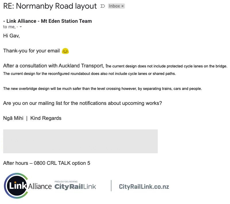
Normanby Roundabout
Next Tuesday night the Normanby Rd rail crossing will close to traffic as part of the City Rail Link works so they can build a trench for the tracks to go in. Pedestrians can keep using the crossing till mid-July at which time foot access will change to the temporary services bridge that they’ve built. The crossing will be replaced by a new over-bridge and the roundabout will be raised
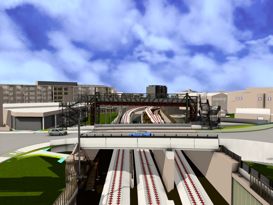
The good news is that it means there’ll be one less level crossing on the rail network. The not so good news is it seems it was designed by someone stuck in the past with the bridge containing only narrow footpaths and no safe cycle infrastructure.
Normanby/Boston Rd Roundabout is being rebuilt as part of the CRL works, and it's not looking promising. pic.twitter.com/5Z4tC8KEia
— Timmy (@gallicist) May 17, 2021
It’s astounding that in 2021 we’re still building infrastructure like this.
Speaking of Auckland Transport and cycling.
Hahahaa these guys are pranksters pic.twitter.com/sK6nbgvEbi
— Ruatara (@ruatara) May 26, 2021
You know what would really improve the experience of cycling, not fearing for your life on a bike because AT actually built some safe bike infrastructure.
Sleepyhead Development
Sleepyhead’s plan to build a company town at Ohinewai, about 6km north of Huntly, was given the green light by independent commissioners this week. The plan is sold as potentially bringing 2600 jobs and 1100 homes for 3000 people to the area.

The main problem I have with the development is appears to be being designed with auto-dependancy baked in. For example, the site is next to the Waikato expressway and rail line and houses will almost certainly be sold as being close to Auckland and Hamilton but is at the far end of the development so even if a rail station was eventually built it won’t be within easy walking distance. In another example, there is already local primary school in Ohinewai but it’s on the other side of the rail/expressway but even putting aside the distance issue, there isn’t even footpaths on the bridges.
As proposed, the *closest* house in the development would be a 21 minute walk (at adult-speed) to the local primary school. Here's what that walk looks like today. Yep, there's proposed "walking network and possible connections"… I guess the question is, who'd pay for that? pic.twitter.com/33S4kjuRR4
— Jolisa Gracewood (@nzdodo) December 7, 2020
One thing I do find funny is Waka Kotahi opposed the development because they’re worried about the impact it will have on the expressway, for which they say they want the capacity left free for trucks. This must be the first time they’ve had a motorway/expressway and not wanted more people to use it. It’s also at odds with their positions in Auckland where they’re keen to use the slightest hint of more housing to build a heap more motorway projects.
Sylvia Park and New Lynn apartments
Some interesting news this week that the owner of Sylvia Park and Lynmall plan to convert some of their existing carparking space into apartments that they’ll rent out
The company also revealed today it has applied to develop many apartments at Mt Wellington and in New Lynn, in a scheme Mackenzie said some years ago he wanted to implement: high-rise residential apartments specifically built to rent out long-term, to be developed in what is now asphalted flat ground-level car parking areas around two malls.
“Build to rent accommodation remains a potentially exciting opportunity for Kiwi Property. The asset class has a low correlation to office and retail with lower volatility, helping to further diversify the company’s earnings. Development schemes are being prepared for build to rent at Sylvia Park and LynnMall, with the consenting process underway for both projects” the company’s result said.
Mackenzie said around 500 apartments are planned in four blocks: 300 units in three blocks at Sylvia Park and 200 units in one block at LynnMall. Consenting applications have been made for Sylvia Park and are about to be lodged for LynnMall.
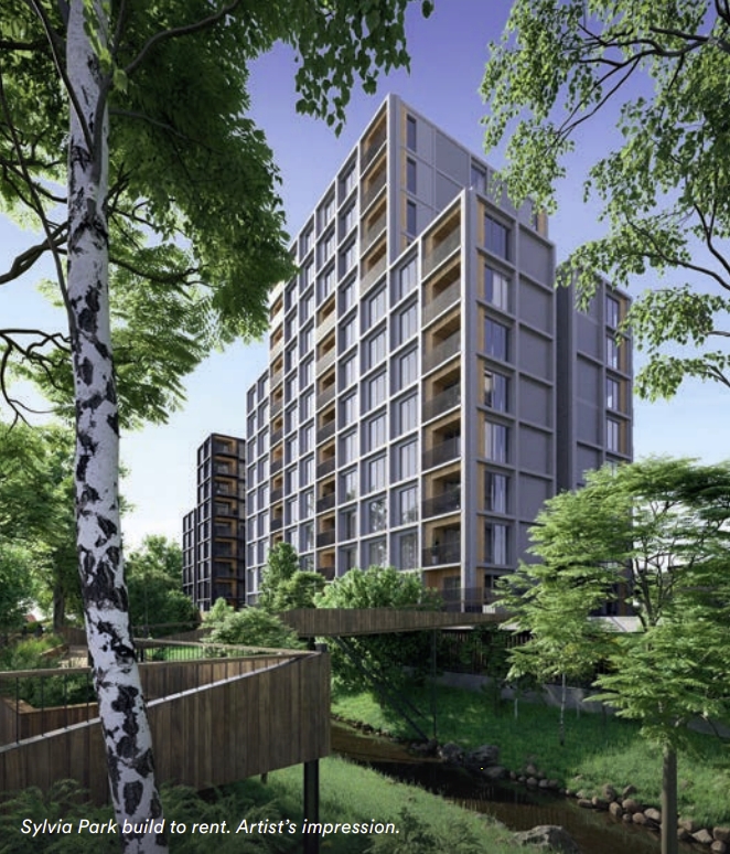
The apartment build to rent model is much more common overseas but we’ve started to see it appear here with the likes of Ockham’s Modal apartments in Mt Albert and is hopefully something we’ll see more of.
Wellington bikes
Earlier this week saw pop-up bike lanes appear in Wellington, which we covered here. After they were removed by the council they were reinstalled again the next morning prompting some interesting comments from the council spokesman.
MacLean said the council had safety concerns with the unsecured plant boxes and potential conflict with other road users.
“Even though we do understand the frustration of the people who are putting in the unofficial bike lane, we’re not happy about the safety aspect of what’s going on,
“Our stance is the plant boxes are creating a hazard for all traffic. They are blocking a whole lot of carparks that are popular with people playing football at Wakefield park. They’re not going to be happy about the situation,” MacLean said.
and in a separate piece, this
Council spokesperson Richard Maclean said putting the boxes onto the road was especially dangerous in areas with heavy traffic.
“We just want to have an adult conversation and say ‘look, we know what you’re frustrations are all about’, but as an organisation that’s in charge of keeping the roads safe, we can’t let this keep going on.”
Do those “adult conversations” including that he’s suggesting that parking for people driving to play football once a week are more important than people’s safety every day – perhaps they would cycle to football if it was safer to do so.
Do those conversations also include that Wellington’s parking policy, adopted just last year, puts cycleways as one of their highest priority uses of streetspace with parking as low to lowest priority?
— Leigh Hunt (@leighghunt) May 24, 2021
On the good Wellington good news front, yesterday Wellington Councillors voted to spend $106 million more on cycling that was in their original plans.
Yet again Tamatha Paul is ignoring the need to not actually do things in local government, appears to be set on undermining the entire system https://t.co/JsbifflwTy
— Hayden Donnell (@HaydenDonnell) May 27, 2021
It’s great they’re funding more cycling and hopefully they can actually deliver on that, unlikely Auckland Transport seems capable of.
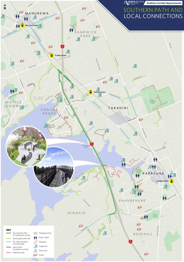
Southern Path
Last Friday the new 4.5km long cycleway alongside the Southern Motorway between Takanini and Papakura finally opened, over a year and a half after the additional motorway lanes were opened.

It’s certainly a useful new link and will be extended another 4km further south as part of the project to widen the motorway to Drury. Hopefully it can also be extended north, including upgrading the existing bike lanes on Gt South Rd.
Finally
We could do with some of these traffic lights
https://twitter.com/TfL/status/1397858203866632199?s=20
How about this for the city centre and Dominion Rd.
If you really want streetcars/trams to drastically transform transport in your city, you need to do what they did in the centre of #Strasbourg: drastically limit cars. #France pic.twitter.com/okQBVgMxmZ
— Taras Grescoe (@grescoe) May 26, 2021
Have a good weekend.

 Processing...
“the owner of Sylvia Park and Lynmall plan to convert some of their existing carparking space into apartments”
For Sylvia Park, this is inaccurate – the apartments are going on land to the north on Lynton Road, replacing existing houses. No changes to car parking in the centre.
It’s to be commended, of course. Though I saw a low-quality image and they didn’t look in the best location for the overall development. probably because its a retrofit of sorts – residential wasn’t originally in their plans?
Hopefully the private sector getting in this space can have it all planned up front as a truly integrated; apartments above malls and carparks. That type of thing.
I gave up on Sylvia Park for New Lynn and St Lukes, because it’s really hard to find a carpark. I usually buy everything I need from local countdown in the walking distance, and if I’m going to a big mall like this one I usually have a carful of five family members and I’m going to have a really full boot of stuff, so train isn’t really an option. Maybe it’s good for them to breed new customers just next to their door instead of the carpark.
Matt L
Can you shed any light on the small strip of road poles outside Waitemata DHB on Taharoto Road, opposite Smales Farm. I can’t imagine that it is for cyclists safety?
I was wondering the same thing JW.
Last night there were cones to the west (NW) leading into the barrier poles as well.
I was thinking I’d like to move those cones east along the road to the bike lane pinch point past the Z petrol station but before Rangatira Ave.
Every time I ride through there cars fly past inches away. I now move out and some drivers feel it’s so narrow (because it is!) they won’t pass until i turn off onto Rangatira.
Terrible piece of road!
Ma, yes a terrible piece of road. Shouldn’t this be a signature piece of road for change if AT is serious about mode share shift? Here is the access road for many hundreds accessing Rosmini and the two Westgate schools. It is also a route to Smales Farm. It is little wonder that biking to Smales is unpopular. Then add in the hospital where it would be useful to access by bike (not helped by the fact that the DHB has prioritised cheap parking at the expense of healthcare.)
The piece about either AT or Council being serious about mode share was of course a tasteless joke.
“not helped by the fact that the DHB has prioritised cheap parking at the expense of healthcare.”
I agree the DHB has hardly led the issue, but while working for the DHB I have seen the blizzard of opposition from health sector unions and other staff groups when any attempt has been made to increase the parking charge. This is regardless of the fact that current staff charges ($3/ day) are effectively a huge subsidy that incentivises driving to work.
Seriously? You think sick people and their families are cash cows? I promise you John, 99% of the public don’t want to be anywhere near a hospital. Nor do I think they want to be biking to visit sick and injured love ones especially in tge wee hours. But if they really wanted to, there’s nothing stopping them.
I am think political ideologies and point scoring around hospital parking is mindless.
Sick people and their families cannot access the hospital because the parking is so cheap that it is completely full all day. Priced parking is accessible parking.
Those sick people and their families pay about $20 per day. (or about $4 per hour for short stays)
I heard it used to be cheap but it would always be full because people would park there and then take the bus to work.
Yes and buses are held up through park Rd while queues of cars turning block the bus lanes. Happened to my wife yesterday who took the bus for a child’s checkup visit at Auckland.
It’s less than $3 per hour at Auckland Hospital. This is obviously far too cheap because it’s full.
No idea what’s happening sorry and nothing on ATs website under the current works and disruptions.
AT’s comms are a really bad joke. Hopeless organisation.
I was wondering the same. It looks like traffic management for some hospital project.
So if it’s possible (and it appears to be) and desirable (presumably that’s why it’s there) for some short term project, could it be achievable to have it on a longer term basis (I am suggesting the life of the poles as a trial, and this is Takapuna and not Onehunga) for the safety of cyclists?
They are for traffic management. There is a new hospital building being built and the site has truck access from Taharoto Road. I thought the poles might be so trucks do not move into the bike lane before turning but not sure. It’s a three year project.
I think the bike lane is gone now and the posts are to mark out the space for pedestrians to get around. At least thats how it looked to me.
Hi Ari, I checked today and bike lane is still there. Footpath is open but now has open gate to walk through and is probably used for pedestrians to stand behind when trucks cross over footpath.
That roundabout is shocking. Why don’t they do it right first time? It’s almost as if the consultants and AT do a half baked job on purpose so they can ensure themselves a nice “little” upgrade project in the future. I don’t get why ratepayers are not up in arms about this sort of thing. Can you imagine if your builder handed over a newly built house without a kitchen and then said “yeah it was a bit too difficult so we cut it, but hey here’s an idea, pay us the same again and we’ll retrofit it for you”
AT did the corner of Karaka St and Taharoto Road twice within the space of about 4 years – outstanding.
This is a large part of the reason that there isn’t more money for active mode; not as large a part though as there is no aptitude for it.
And of course when any piece of cycle infrastructure is added the cost is the first thing they highlight in a press release – thus getting the ” they spend $$$millions on cycle ways ” crowd up in arms, and yet any active modes spend is a tiny fraction of the moar roads spend.
Absolutely. The hurdles that have to be jumped to repair the network as opposed to continue building the wrong stuff.
Even if they don’t care about cyclists, why build a roundabout? They simply don’t work very well for anyone including cars on busy roads in peak periods. They all need to be removed and replaced with lights. Surely they would have worked this out by now!
Are you saying you want the roundabout to be triple the cost and the business on two of the corners of the intersection to be demolished along with the protected tree removed to make space for a better cycleway, when the objective of the project is to build a rail tunnel?
A dutch roundabout can be built in that location with 0 land take. All you need to do is move the ped crossings closer to the intersection, make them shared paths and give them priority.
I think you’re overestimating how much space there is there, or underestimating how much space a roundabout takes up.
I think you are overestimating the space required. If the speed limit is 40km/h or less you only need a 40m diameter circle between property boundaries to build a Dutch roundabout.
No Weka, I’m not underestimating how much space a roundabout takes. The designers on this occasion have chosen to ensure horizontal deflection by tracking for the biggest check vehicle possible and then some which is what blows out the space requirements. You can absolutely achieve a safe system roundabout on the same footprint.
Why bother making it large enough for trucks? Why bother with a roundabout at all?
It looks like an intersection of what should be quiet back streets.
Some great news just in: https://www.stuff.co.nz/national/125272333/te-huia-hamiltonauckland-train-services-to-increase-sooner-rather-than-later
It is indeed great news. Now WK just have to toll that section of SH1 and Te Huia would really hum.
Yes.
They still need a few North Waikato stops to really make this hum with numbers. Unfortunately that will extend time out a bit. Puhinui for Papakura, when the former is ready. If this announcement is stage 2 (or 1(a)), then those additions should be next.
Interpeak services would be the real winner if people in some of these towns and work in Hamilton or at The Base could train in and out each day.
Timing of services will be critical also integration with buses and train. Assuming they stick with Papakura in the short term for weekday less train miles for Te Huia.
How much time is lost for each stop? Considering dwell time should be short and the thing is so slow that time lost in braking/accelerating for each stop is hopefully not that long? 3 mins per stop?
Kraut , when they had the open day at Rotokauri I was told they were looking at 1min , but then again it could be more when they have use the Handicap hoist , as what is shown in the video I posted below .
Sorry I mean including the time lost for slowing the train, rather than just stopped at the station. Of course, getting the service to Puhinui would make it faster overall, so adding new stops wouldnt have much of a net effect
2 Questions , 1] Will the Saturday service go via Newmarket and make a stop at say Puhinui for those that want to go to the Airport ,
2] And with it stopping at the Strand will AT be putting on special Buses for the .passengers to get into the City centre as what I ave seen the last 2 Saturday services have a large number of aged persons on board .
And this is what last Saturday looked like at Papakura ;-
Don’t show that video to the clowns in the comments part of the article above, they might call a full train fake news!
No safe cycle route from Papakura Railway station to the “Southern Path”?
Give people a chance.
Looking at a map the Papakura train station doesn’t appear to be something that the path is all that useful for anyway.
The train station is close to the train tracks, the shared path is close to the motorway. In South Auckland, the NIMT and the motorway are generally not close to each other, which is why there’s a spur to Manukau but the motorway goes right by it.
That being said, some of the most insane painted on bike lanes you’ll see (even by Auckland standards) do exist at the traffic lights around the motorway junction. And, honestly, along Beach Road there is room to stick in a kerb and say “here you go cyclists”, or widen the path and say “here’s a shared path, lol”.
(There’s some separated bike lanes on the other side, running from Karaka but they peter out well short of the motorway. For some reason this is labelled as an “on road, not protected” lane on the map. I was there the other day, much of that blue line should be some other colour.)
It’d be more accurate to describe the Southern Path as running between Pahurehure/Rosehill or Karaka and Conifer Grove, than Papakura and Takanini.
https://imgur.com/a/fbT97hj
I’ve taken to taking pictures of cycling infrastructure, which is why I have these. Quality’s not brilliant, but as you can see the bike lane (at least, on this side of the road) is neither on the road nor a shared path, until suddenly (and randomly) it becomes a painted on green strip. If I had to guess, the green strip was there before they did all the development to the right and they couldn’t be arsed extending the separated bike lane.
All the newer developments in the area have separated bike lanes, but new is newer than 2013 because the Warehouse Takanini is surrounded by new development of about that vintage which, in general, lacks the now typical road designs you see in Auranga, down Park Estate Road and Paerata Rise (which is much further away, in any case).
In other interesting design choices. This crl render of the Beresford square entrance is interesting. Two escalators separated by a decently long switchback walk. Probably couldn’t have done anything else.
https://ibb.co/DK9yvns
I’m assuming that they’ll use that space for the gatelines (HOP card tag on / tag off). Much better than using precious space on the surface or at the platform level. Note it also separates people traveling by lift and by escalator so they don’t clash.
A Pitt St underpass and entrance on the other side of the road looks like a missed opportunity. even if it was just stair access.
Yes the space between escalators is for ticket gates, but I’ve always thought they’re unnecessarily far apart, and the walk distance could have been shorter. Much of it is just corridor https://youtu.be/KXqko7pcVXM?t=191
Surely a wide pedestrian crossing at Beresford (phased with the Karangahape Road lights) would be a better outcome there? There is enough room between the two for a couple of busses so it shouldn’t get too blocked (just add some red light cameras for good measure).
Port Sleepyhead is a natural outcome when the Auckland Council fails to allow for enough industrial and residential land on the edge of Auckland. “No Sprawl” they said and so we get land developed even further away.
There’s more to it than that. Too much of the existing model for industrial land is taken up with enormous carparks. Residential developments are still based on a sprawl and car centric design idea. Other cities with more industry than we have take up less space than we do. We don’t need to sprawl we need to improve our design.
And Sleepyhead is paying neither for the community facilities of a proper workplace based township nor for a proper design to enable healthy living there for the entire family.
This is probably a natural outcome of RMA decisions being based on faulty technical understanding of the effects of different development types; certain effects are misunderstood and others are ignored.
Heidi
I am more cynical than you. This is all about “cheap” land. That’s why we have big box retailers on the edge of towns because it suits their profit models. Of course the land is only cheap for the purchaser because the employee/ consumer will pay the cost of getting there, and the tax payer will pay for much of the infrastructure.
Oh for user pays road system (like water, electricity and gas) that would help level the playing field and encourage use of more sustainable transport options.
It is all about the price of land. Industry needs land at $1000 per square metre or less. In Auckland it is now somewhere around $2700. That is because of the constraints on the boundary that have been increased since the early 1990’s (Auckland Growth Strategy). Compact city and all that. Now industry is retreating outside the Metro area, Pokeno is practically done so that means elsewhere in the Waikato District.
The anti-sprawlers have done this. The irony is things end up even further from the centre.
What’s your solution?
Make use of the vast areas that are available but can’t be used because of regulation. It is true that Auckland is constrained by its topography on the isthmus but once you get south of the Manukau Harbour there are no constraints other than artificial rules. Everything from Karaka and Kingseat south is used as poor farmland. We could have waterfront residential suburbs with jobs behind them.
Where would you prefer to live? In a waterfront suburb or in a high-rise block of flats looking at a railway line?
“Everything from Karaka and Kingseat south is used as poor farmland. We could have waterfront residential suburbs with jobs behind them.”
Funnily enough, I was just looking at this on a map yesterday and thought the same thing. And Karaka Rd means a short trip to the Southern Motorway and Drury rail station.
P.S. And smaller roads to the north of that area get you to Papakura Station, not that you need to build for commuters.
“Where would you prefer to live? In a waterfront suburb or in a high-rise block of flats looking at a railway line?” – I would prefer the latter if the former is miles from the city, but that is just my preference.
I agree with you miffy, people should be able to live where they like. But they should also be made to pay for (or put up with) infrastructure. So if you did decide to live in Karaka at the end of the already congested southern motorway, then don’t complain about congestion unless you want to pay an outrageous charge to fix it.
I’m certainly not for sprawl and you are right, if it is going to happen it needs to be managed better and land could be freed up and cheaper. However, this is Waikato we are talking about and bringing jobs to an area about that’s soon to lose the only industry for km’s around, the Power Station. Matts post really has nothing to do with sprawl, its about a planned neighborhood that is completely auto dependent and ensuring a new generation grow up having to be hauled to school in a car and this would be the case whether its Ohinewai or Kingseat.
As for living on a waterfront 90 mins from my job, friends, hobbies and generally anything worth doing vs in a highrise near a train station, like a lot of people I’ll take the train station. Don’t assume you know what people want.
Joe, why children couldn’t be hauled by school bus?
The point is I am not assuming. If people want tower blocks then they should be free to live in one. But not if the only way they get built is by squeezing up land prices with a shitty rule that stops the city spreading out.
@miffy, do you think we should also keep building infrastructure to support said sprawl?
Genuinely curious.
Part of me wants to say, if you want to make your bed out there, are willing to pay for almost all of it, then fine. Expect awful traffic with no hope of improvement. While most of the tax dollars get spent much more efficiently proving dense infrastructure closer in.
But I also realise it’ll be like people who build and buy into suburbs near airports and then suddenly want the airport to go away. They will want their cake and to eat it too.
Then these towns will complain they don’t have libraries, pools, sports fields or schools. Then they complain about the high rates that follow.
“Then these towns will complain they don’t have libraries, pools, sports fields or schools.”
That is a weak argument. It is far cheaper to provide additional libraries, pools, sports fields and schools in the outer areas than in the built up areas as land is cheaper. Sports fields are provided by the developer either as land or a part of their reserve contribution. Auckland doesn’t have many places where existing schools can take hundreds of new pupils, especially the inner city. The anti-sprawlers who have promoted higher housing costs over the last 30 years have assumed that these costs apply only to new suburbs when they don’t.
I was aware of this as I typed this up but I was kind of referring to Pokeno where the rates were low initially then went up substantially from memory. They realised the downside to travel time and lack of amenities after loving there for a bit.
*living. Probably some loving too of course.
I know people who live in Pokeno and they still love it, I asked and they for sure won’t give it up for apartment or townhouse somewhere closer to the city. They didn’t complain about amenities, there’s a new countdown and other stuff now. One adult goes to the city 3 times a week park-n-ride train through Pukekohe and another permanently working from home. 12 hours of commute a week is not such a big price when kids have a decent lawn to dig warms, jump on trampoline and fry bbq with children. Another colleague recently moved to Waihi and drives to the city 3 days a week, he also considers that this super-commute is a reasonable price.
Speaking about amenities, what are those amenities which available in say Eden Terrace but not available in Pokeno, Pukekohe or lot-criticised Milldale/Millwater?
“It is far cheaper to provide additional libraries, pools, sports fields and schools in the outer areas than in the built up areas as land is cheaper.”
The way to provide the best quality amenities for the lowest cost per resident is in a compact city. This way the cost of the facilities can be shared between more people. By sprawling you don’t just have to provide the new amenities, you also have to accommodate the car dependence that the sprawl creates. That means wider roads, more cars, carparks at each facility – and not just at the new ones, parking demand continues to rise everywhere.
We should be spending more money on new schools within the city. But most of the other community facilities we need actually just need more people using them to increase the value for money. Where we do need more amenities then what we’ll be doing by providing them is “bringing amenities to the people” thus cutting travel distances – enabling modeshift to active modes and reducing emissions.
Heidi, you are right about the cheapest way to provide amenities. North Shore City decided that they needed the Albany stadium and the Bruce Mason Centre, both of which are a drain on ratepayers. With good public transport networks the underused Eden Park and the city concert venues could easily have met this need.
“Port Sleepyhead”
Let the sunlight in – pull some levers to get proper community facilities etc (i.e. make it a proper town).
I always thought that the devolpement Sleepyhead were doing was a company Town , where you rent the houses and at a time when you get fired , leave or retired you move out and find another town to live in .
Ockham is building build-to-rent 32 apartments block in Newton.
https://fb.watch/5LWtWF4y2f/
Also there is “The Ed” is a new build-to-rent building which will be completed in the coming months. Resident Properties are the developer and they appear to have more in the pipeline: https://www.residentproperties.co.nz/our-portfolio/
What will the rent be? I am skeptical until I see the rent. That 26 Aroha development is hyped on its green and social credentials, yet the rent is bloody high.
More chardonnay socialism? No thanks
That Ockham apartments will be around $500.00 plus a week going by an item on the TV news tonight .
Huh, brand new decent quality apartments are expensive?
Never would have guessed.
Great.
Super.
I love the new Southern Path! Agree that it absolutely must extend north to be a meaningful connection. Great South Road is a terrifying place for a “beginner” road rider (me). The local councillor is dead against any form of active mode though – prefers Park & Ride – so a battle for support seems extra challenging. It would be neat if he could see that good cycling connections would free his constituents from the fuel tax he strongly opposed.
The path is great to walk the dogs and there are several access points, including one near Songbird Cafe.
Just a pity that Brylee Drive can’t be opened to through traffic
South Ohinewai road will take you to Huntly without having to shag around getting on and off the expressway.
No it won’t. It doesn’t connect to the old SH1 at all.
Strasbourg is a smaller than Auckland. Somehow they fit some trams in. Pretty sure they were there over 20 years ago when I first visited. Now they have a barge with E cargo bike feeders for freight to the city centre. Max load for an e cargo bike is 180 kg. Saw it on Face TV. Carting paving stones for the city square.
When is the 2021 RPTP out again?
April 1st
Further on from Normanby Road CRL are rebuilding the Mt Eden Road & Boston Road intersection, It is still missing a leg across the road as you can see below
https://twitter.com/TheGradyConnell/status/1395568342879019010
And with the Interpeak service/s that means the crew/s won’t have to travel back to Hamilton by car and the other crew/s can come up by the Train .
Exactly, do they even have to pay more in crew costs, as this was time the crews were being ferried around anyway??
And this from The Breakfast show with John Campbell talking to Minister Woods with a piece about Rail and includes the Auckland Network upgrades . ;-