It’s been more than two months but tomorrow the Auckland Transport board meet again and so as I often do, I’ve had a look through the reports for anything interesting that stands out. Unfortunately, at the time of writing the post they haven’t uploaded the closed session agenda, which gives an indication as to some of the more interesting projects.
Below the the updates I found most interesting from the main Business Report. The order is based on the order the item appeared in the report.
Business cases
One of the things AT are working on, and it appeared in ATAP and the RLTP, is work in areas with a lot of urban redevelopment.
Auckland Housing Programme
The ATAP process identified support for brownfields development as the highest priority for growth investment. To support the Auckland Housing Programme in brownfield areas AT will need to develop ways of working with Kāinga Ora. The Business Case for this investment is progressing and is investigating the public transport and walking and cycling infrastructure to encourage sustainable transport behaviour, along with intersection upgrades to minimise impact on the operation of the surrounding road network.
Those intersection upgrades sound a lot like AT engineers are planning a suite of intersection expansions to push more cars through intersections. If this is what is being planned it would only serve to further encourage driving and make congestion worse. It also ignores that AT needs to reduce vehicle travel.
The other thing that’s notable about this is the amount of space in the report it has compared to the amount of space dedicated to it compared to the work AT is doing in greenfield areas with a page or more about AT’s various activities/planning in support of greenfield development.
Failed Journey Transfer Hotspots
One of the thing that often frustrates many people with AT’s public transport services is that when they work as intended, they can be absolutely wonderful, but often it doesn’t take much for the pendulum to swing all the way to the other side and user experience to fall apart. AT appear to be trying to address this a bit.
Missing a transfer between services during a public transport journey can be a very annoying experience for customers. To reduce failed transfers, the ‘Things That Move’ project was implemented for ferry-to-bus transfers in Half Moon Bay. The Metro Service Optimisation team are now looking to roll this system out to other journey transfers but want to prioritise the most problematic spots.
Part of this prioritisation uses timetable information, AT HOP data, and vehicle location data, however they wanted to include an element of customer feedback. The Data Science team has collaborated with the Metro Service Optimisation team to apply text mining to CRM cases to extract desired customer transfer insights. This proof of concept supports the team to consider customer feedback as they strategically identify the next roll out spots for ‘Things That Move’.
It’s good that this is happening though quite telling it hasn’t happened before now as it really it should have been being done as part of regular network planning and monitoring.
Funding
In the list of projects AT received funding for over the last two months, three things stand out:
- Brownfields Growth – Indicative Business Case – $0.41m
- Transitional Rail – Additional Power Feed Single Stage Business Case (this is funded at 100% FAR through Transitional Rail) – $1.50m
- Auckland Rail – Fourth Main (Regional Rail) (this is funded at 100% Funding Allocation Rate through Transitional Rail) – $1.97m
Note: this is for supplementary information to support the Rail Detailed Business Case being developed through Supporting Growth
It’s good to see something happening about the fourth main, though it’s likely years off actually happening – it really should be being delivered at the same time as the third.
Procurement
AT publish tenders in the report with an estimated value over $2 million and one that stands out is
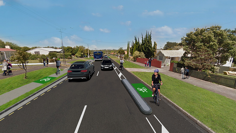
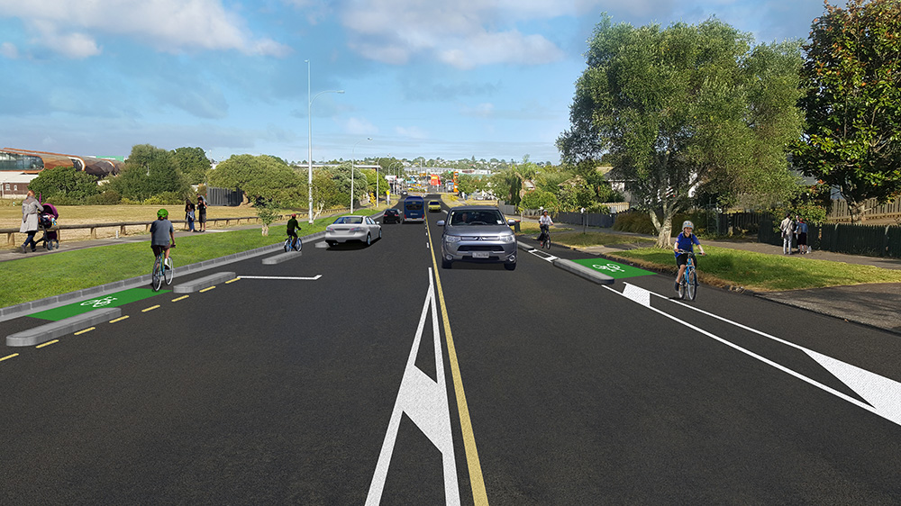
Taniwha Street Cycleway Link Construction (Package 1) – Link to Glen Innes Cycleway project is to complete a missing link in Auckland’s Cycle Network; providing safer, more coherent and attractive routes for new and existing cyclists, including commuters, school children and those making everyday trips forming part of the Urban Cycleway Programme (UCP).
Hopefully this goes ahead, though it’s worth remembering the Urban Cycleway Programme was meant to be completed in mid-2018. There are more details here.
Climate change
There are some interesting comments on climate change from AT in this report
Mitigation
In March, AT – through the Council’s submission – provided feedback on the Climate Change Commission’s draft feedback. AT provided feedback primarily on the transportation policy advice and provided input into feedback on sections related to equity and the local government’s role. AT’s feedback was combined with that of Council staff, Local Boards, mana whenua, and Councillors. The submission supported some of the actions but recommended stronger interventions to deliver the pace and scale of change required in Auckland to reduce transport emissions significantly. A small number of actions were not supported because of insufficient information on their impact on emissions or equity; the submission requested further analysis.
The RLTP has reinforced the challenge of significantly reducing emissions from the road transport system, with a potential reduction of 12% (2016 to 2031) after accounting for population growth, RLTP spending, the Clean Car Standard (government fuel efficiency standard), proposed biofuel requirements, and potential electric vehicle incentives. The Auckland Climate Plan has a target of a 50% reduction by 2030 (on 2016 emissions) for all of Auckland, with an expectation of a 64% reduction from transport (this over-contribution reflects that emissions reductions will be more difficult in other sectors). Over the coming months, AT will model a range of scenarios to demonstrate what actions are needed to achieve the target reduction; this scenario modelling will include a wide range of actions across AT, Council, Government, and Aucklanders. The intent is for these scenarios to show the level of investment, policy change and behaviour change needed, enabling discussions with Councillors on which scenario to adopt.
Adaption
Work is continuing on identifying, assessing, and prioritising climate change risks to AT’s customers, staff, services, and assets. This work has involved input from AT and Council-family staff, Local Boards, Waka Kotahi, Kiwirail, and mana whenua. This work, which is seen as one of the most comprehensive in New Zealand, has highlighted the necessity of greater co-ordination across the Council family on climate change risks. The Council Sustainability Office has begun co-ordination.
In May, a project update will go to the Finance and Assurance Committee, with the completed work taken to the Committee in July for endorsement before going to the board. Internal discussions have begun on how to prepare AT for climate change adaption.
It will be interesting to see what AT’s feedback was and specifically what they wanted strengthened and what they didn’t support.
As for the modelling, it does have the potential to be quite useful as we tend to only model forward i.e. here’s a project what we want to do, how good/bad will the impact be, and not model backwards from a goal and work out what it would take to achieve it. The risk here though is it relies on AT’s models working properly and they typically tend to underestimate the potential uptake on walking, cycling and PT where those options have been provided well. That means there’s a greater likelihood AT will turn around and say something to the effect of “it’s too hard to get people out of their cars so it’s up to the government to give more incentives for people to switch to electric vehicles, oh and we need more and bigger roads to support them“.
More frequent HOP Top-ups?
One of the more interesting updates suggests AT are finally working on improving one of the long-standing bugbears of HOP, that online top-ups take a day to appear on the card.
On Bus Connectivity
The frequency of action list updates across AT’s fixed train, ferry devices and bus depots has been increased from twice daily to eight times per day. A plan is underway to further ramp-up this frequency over the coming weeks. Customers will realise the benefits of this as actions are applied to their AT HOP card more quickly, for example balance top-ups.
AT’s technology team love coming up with new uses for their cameras and this time they say:
Computer vision has been built at the Wellesley Street and Victoria Street intersection to detect how often a queue is being formed and how often it reaches a certain point on the road. This will allow the engineer to get a better understanding of the scale of the issue and result in an informed decision being made on whether the traffic signal phasing should be adjusted. Three categories of queues have been developed (short, medium, and long) and will be measured accordingly.
That certainly is a tricky intersection and one that can cause long delays for buses. What would also help manage it would be reducing the number of cars in the city centre.
If you’ve looked through the report, is there anything else that stood out to you?
Update:
One thing I forgot to add was this graph from AT’s indicators saying they’ve hit their cycleway target for the year. Tamaki Dr was opened at this time but that’s not enough to cover that jump unless they’re counting it twice, once for each direction. I wonder if they’ve also included the Herne Bay to Westhaven which started life as a cycleway but became just a traffic calming project yet AT are likely still claiming the km as cycleway.


 Processing...
Like the Taniwha Street Cycleway Link AT also approved a bikeway from Otahuhu to Sylvia Park that was to begin construction over 2 years ago. But it has been dropped. These are low cost projects that would give good outcomes. I wonder how many similar projects have been dropped.
AT seem to be concentrating on bikeways alongside train lines eg Avondale, Meadowbank rather than the more effective stuff connecting schools and local suburbs.
Yes, and not only should the Urban Cycleway Progamme have been finished by 2018, the full Auckland Cycle Network should have been 70% finished by 2020, with the remainder done by 2025.
The cool thing is that we can still achieve the 100% by 2025 date. We can learn from the European cities’ Covid rollouts and the developments they made to use methods that provided excellent protection (NOT painted lanes) while bringing down the costs markedly. So whereas Seville’s costs a few years ago for a rapid rollout were in the order of 250,000 euros / km, Berlin brought that down to 9,500 euros / km.
Judging by the on going construction of foundations for the overheads it looks like the third main will extend halfway from Westfield junction to Sylvia Park. All good but I expect it makes it difficult to use the rail corridor to construct a cycleway. I am becoming increasingly up happy about the railway becoming a hindrance to walking and cycling and public transport between Wiri and Penrose and Otahuhu and Sylvia park. This hasn’t being helped by the closure of the four stations of Wiri, Mangere, Westfield and Southdown which served workers to industry in the area. Southdown station provided a convenient short cut across the railway from Great South road to the cycleway that runs along the foreshore between Hugo Johnston drive and the Onehunga port.
One immediate change would be to reroute the 670 bus to New Lynn via Onehunga to start at Otahuhu town centre and then proceed to Otahuhu railway station and along sales yard road onto Great South Road then Neilson street. At the moment it starts at Otahuhu station goes to the town centre and then onto Great south road meaning any passengers from the rail station take a 10 minute tiki tour of Otahuhu that they don’t need or want before proceeding to their destination. I have posted before about extending the 321 Hospital bus to the Manukau super centre which would service more areas along the rail line.
But back to walking and cycling. There is a need for a pedestrian bridge across the railway in the vicinity of the old Southdown station. Also what about a walkway/cycleway around the mudflats from the Mangere side of Otahuhu station to Hugo Johnstone drive where it would connect the cycleway to Onehunga Port. I understand there are plans to create a path to Mangere bridge. However a complete circular route around the inlet would be even better.
Speaking of Southdown, is that line (or rather the designation) from Avondale a dead-duck?
Still designated AFAIK (& KR still own the land). Whether it’ll ever be built …
I’ve asked for updates and OIA’d facts from the Otahuhu to Sylvia park cycleway routinely over the last few years and every time its a different excuse why it isn’t happening. First it was being redesigned to be bigger and better, then they had held off to align with other roadworks. The latest one before the Covid budget constraints was they were waiting for works to be carried out on the Mt Wellington highway to update storm drains… Now there are ‘major works’ happening at the southern motorway interchange to add an additional south bound turning traffic lane from Sylvia Park road but haven’t seen any drawings on this. So much wasted time and money on all these council and AT staff delivering sweet FA for years. I’m going to let them have it if there isn’t adequate improvements to the walking and cycling crossings here (which I’m pretty sure there won’t be or it would have been published surely).
This stood out to me in the section labelled Parking improvement projects”:
“Vincent Street: ‘No Stopping Off Roadway’ signs were installed 8 April 2021, to prevent vehicles from driving on the footpath and parking on the grass berm.”
Cool, cool. You can drive on every other damn footpath in Auckland then.
Berm parking should not have to be banned on a berm-by-berm process – this is impossible to scale effectively.
It should instead be banned as standard, then reconsidered on a case-by-case basis.
Yes, and that’s what the road code already says, but …
Interesting they called it a grass berm; I thought they might argue it’s not grass…
Can the model ‘disappear’ traffic? If not, it will be less than useful. Plenty of evidence from highway removals and road diets elsewhere show that significant numbers of low value trips just evaporate, ie traffic volumes drop, alternatives increase, but not in a one to one ratio.
Given our extremely high rate of driving it seems likely that a meaningful chunk of traffic volume can evaporate to the benefit of the economy, environment, and people’s wellbeing.
Would be very useful to run scenarios with re-purposed lanes, to transit, to active, to freight, but only if the model is sophisticated enough to show negative elasticities with a range of possible outcomes. Especially with pricing included and the new increased viability of Work From Home options.
Wow you mean to say they can’t of done this previously with a couple of changes to program code? Wonder what the issue was/is:
“ The frequency of action list updates across AT’s fixed train, ferry devices and bus depots has been increased from twice daily to eight times per day. A plan is underway to further ramp-up this frequency over the coming weeks.”
Surely the data storage wasn’t the bottleneck, the data can’t take that much up by today’s standards?
“Surely the data storage wasn’t the bottleneck, the data can’t take that much up by today’s standards?”
The delays were caused by: 1. The newly formed Customer Experience Division, not understanding the pain that the previous twice per day update system caused, and how it contributed to the poor reputation of PT travel on the AT network, 2. The previous HOP team not knowing or not understanding the pain that the previous twice per day update system caused, ( and their unwillingness to do anything about it ). 3. The IT/BT Team not seeing this as a priority, 4. The Commercial Team not willing to pay for additional data transfers, etc etc. The prevailing unrealistic attitude was ( “tell those customers to transfer money to their HOP card three or four days days before they need to use the bus” )
Wow. Thanks. So this outrageous situation has been created by just poor attitude and ignorance all along?
Well, good on whoever has finally got some action.
How can management support you to make some more good changes?
By resigning?
ahhh thanks BusDriver
Oh Sorry that’s not meant to be a reply to you Chris.
“Computer vision has been built at the Wellesley Street and Victoria Street intersection to detect how often a queue is being formed and how often it reaches a certain point on the road. This will allow the engineer to get a better understanding of the scale of the issue and result in an informed decision being made on whether the traffic signal phasing should be adjusted. Three categories of queues have been developed (short, medium, and long) and will be measured accordingly.”
That certainly is a tricky intersection and one that can cause long delays for buses. What would also help manage it would be reducing the number of cars in the city centre.
Yes well said Matt- reducing the number of cars would fix it and should that be the first solution in a climate crisis?
I have a more cynical view of how the results will be applied. I suspect they will enable car movements to and from the suburbs of St Marys Bay and Ponsonby to the detriment of the NEX2 and other buses; much in the same way that the phasing at Halsey St/Fanshawe appears to favour car movements to the Wynyard Qtr at the expense of the NEX2 and other Shore buses.
If you can buy an item from say The Warehouse using Polipay or your Credit/Debit card or even recharging your Phone and the money is there right away , Why can’t AT’s Hop do the same ? . It can happen on their Machines or Service Centres but not online .
It’s a bus issue. There’s 1200 or so of them wandering around and they only get updated at the depot.
How can it be a bus issue only , AT have many other stand alone Hop readers at the Ferries and Railway Stations and people tag on/off at those places so anything that is put on the card online should be there not 48plus hrs later . And it goes to prove their system is way behind the times .
I’ve never tried, but I think perhaps the fixed tag on/ off readers at train stations say will apply your top up to your card immediately / at least quickly. I’ve never tried. The only reason it wouldn’t is because of some artificial limitation.
I understand why the busses top up is slow however. You can’t really rely on cell service.
There are two types of hop terminals, fixed ones at train stations and ferries that are hard wired to the internet and get instant updates, and bus ones onboard that are only updated at the bus depot.
Your card doesn’t do much except get recognized by the terminal. All top ups are pushed out to every terminal, which stores the data until the appropriate card is tagged to it to transfer the information to the card.
If your bus hasn’t been back to the depot to get the latest batch of top up data over the wifi yet, thenit won’t have the instruction and you’re card won’t receive it. Hence why it usually take an overnight wait when using the bus, and in some very rare cases up to 72 hours.
The best thing to do is have an autotop up loaded on the card, this always and immediately works because its the same instruction on the card, it doesn’t rely on new instructions being broadcast.
As I’ve said before (and I work in financial transactions at my company) for even POLi payments there is an issue if the transaction on the merchant website fails on a Friday or weekend. The money goes out from the customer’s bank account but my company only has visibility on the Monday (for Friday attempts) or Tuesday (for weekend attempts) for my team to complete the transaction offline for the customer. So there is also a banking issue as well.
They did the opposite of the Things That Move programme at Matiatia on Waiheke. Previously the buses waited for the ferries to arrive. Now if the ferries are running late, there’s no bus for an onward journey. Really not fun on a cold windy evening (which is when the ferries are often late due to going a longer route for a calmer sea in bad weather). So now there’s a risk that if one takes a bus to the ferry one might get stranded. Making the car relatively more attractive. I can see they’re trying to have the buses run to a schedule, but of course they run on time but mostly empty without the ferry passengers.
Happens often at Hobsonville, where passengers on the ferry from the city get to watch their connecting bus leave the wharf just as they are tying up, Whoever drew up that contract should be shot
Yes it’s been the topic of a recent Todd Niall article.
“Whoever drew up that contract should be shot”
The AT planner responsible for the Hobsonville bus schedules claims that this is a “communications issue” and not a scheduling issue! ie “tell those passengers to use an earlier bus or an earlier ferry”
I’ve noticed the lack of frequency in the mornings of the City Link. I think it’s supposed to be every 6mins (and there are a lot of people transferring like me from the train at Britomart to the City Link buses going both ways) but for the direction of Wynyard it’s been more like 12-13mins wait time. Not a great transfer experience for the CBD. And yes they need to get cars out of that Customs West/Quay St area that’s holding up buses in the PM peak trying to get into Lower Albert of in the case of the City Links to Queen St. There’s always a big queue of traffic there.
“I think it’s supposed to be every 6mins (and there are a lot of people transferring like me from the train at Britomart to the City Link buses going both ways) but for the direction of Wynyard it’s been more like 12-13mins wait time.”
This is due to road congestion caused by single occupancy car drivers, that choke up KRoad and Queen Street. One more reason why cars should be removed from Queen Street.
Sounda more like a case for proper busanes everywhere
What about the ‘missing link’ of the cycleway through the Manukau Super Clinic , the wetland domain at Wiri?
Why the are no any pathways through so called Manukau Healthpark?
What about the missing link of the Puhinui cycleway through the Manukau Super Clinic , the wetland domain at Wiri?
Why the are no any pathways through so called Manukau Healthpark?