Here’s our weekly roundup
Mobile Fine Increase
The government are increasing the fine for using a mobile phone while driving.
The infringement fee for using a mobile phone while driving will increase from $80 to $150 from 30 April 2021 to encourage safer driving, Transport Minister Michael Wood announced today.
Michael Wood said too many people are still picking up the phone while driving.
“Police issued over 40,000 infringement notices for this offence last year. Driver distraction is a serious road safety issue, and inattention – including from mobile phones – can have tragic consequences.
“Between 2015 and 2019, there were 22 road deaths in New Zealand and 73 serious injuries where drivers were distracted by a mobile phone. This is likely to be under-reported as it can be difficult for Police to detect phone use when they attend crashes.
“Increasing the infringement fee to $150 means it will now match similar offences. This is our way of saying Kiwis need to take this seriously and put away the phone while driving.
This seems like a good change but what would really help is if the police did more to enforce it. Anyone who rides a bike or even just walks around will know that phone use while driving is rife and more needs to be done to tackle it.
As part of the announcement they also included these stats.
Based on the period 2009 to 2020:
Only 4 per cent of infringement notices are issued to those aged 19 years or younger. However, between 2015 and 2019, 44 per cent of fatal crashes where a mobile phone was a distracting factor had a driver aged between 15 and 19 years old.
15 per cent of infringement notices are issued to those aged 20-24 years, 18 per cent to those aged 25-29 years, 16 per cent to those aged 30-34 years, and nearly half (48 per cent) to those aged 35 years or older. However, between 2015 and 2019, three-quarters (75 per cent) of serious injury crashes where a mobile phone was a distracting factor involved a driver between 15 and 34 years of age.
Project Wave (aka Nelson St stage 3)
The first stage of the Nelson St cycleway, from the motorway to Victoria St opened way back at the end of 2015. Stage 2, from Victoria St to Pakenham St opened about in mid-2017. Before that was even completed, the final piece, getting it from Market Place through to the cycleway on Quay St, was consulted on. Then, like so many other cycleway projects it just seemed to disappear.
The project is finally back, but only as a trial under Waka Kotahi’s Innovating Streets programme and called Project Wave..
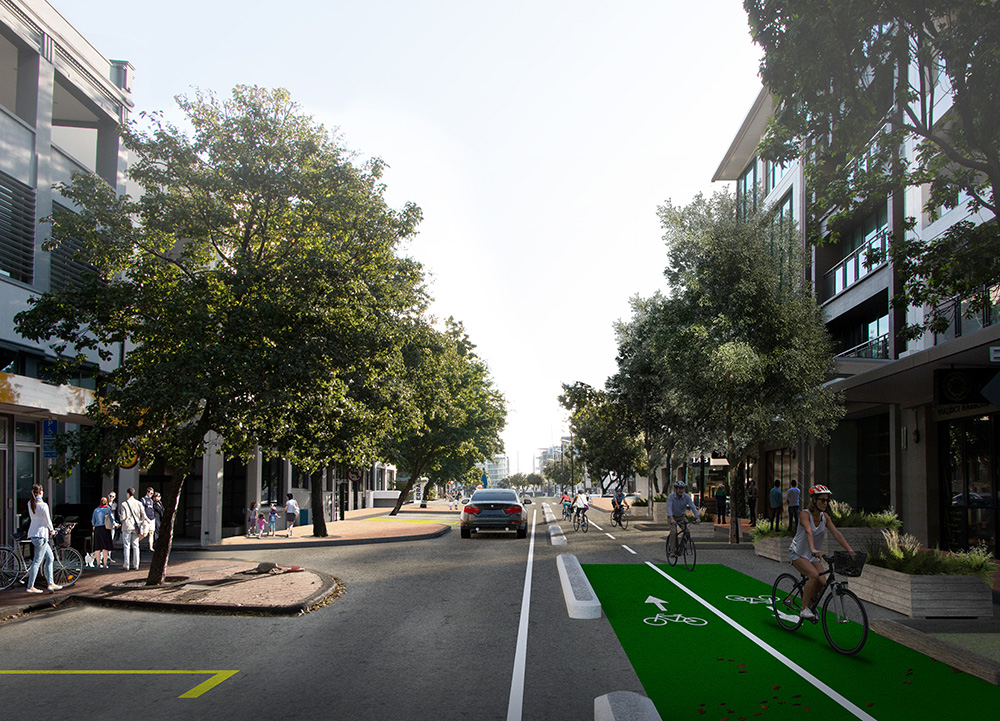
Auckland Transport (AT) and Panuku Development Auckland are working together to deliver Project WAVE – a trial cycleway through the Viaduct area of downtown Auckland, connecting the Nelson Street and Quay Street cycleways.
Additional loading zones, pedestrian crossing points, and a one-way system also form part of the trial, which encompasses Market Place, part of Customs Street West, and Lower Hobson Street.
The short construction period is expected to begin this week. The cycleway will open in stages and is expected to be fully open by mid-May 2021. In mid-2021, AT will decide its long-term future.
……
Auckland Transport (AT) and Panuku Development Auckland are working together to deliver Project WAVE – a trial cycleway through the Viaduct area of downtown Auckland, connecting the Nelson Street and Quay Street cycleways.
Additional loading zones, pedestrian crossing points, and a one-way system also form part of the trial, which encompasses Market Place, part of Customs Street West, and Lower Hobson Street.
The short construction period is expected to begin this week. The cycleway will open in stages and is expected to be fully open by mid-May 2021. In mid-2021, AT will decide its long-term future.
I’m glad this is finally happening but doing this just as a trial really highlights how bad AT have become on cycling delivery.
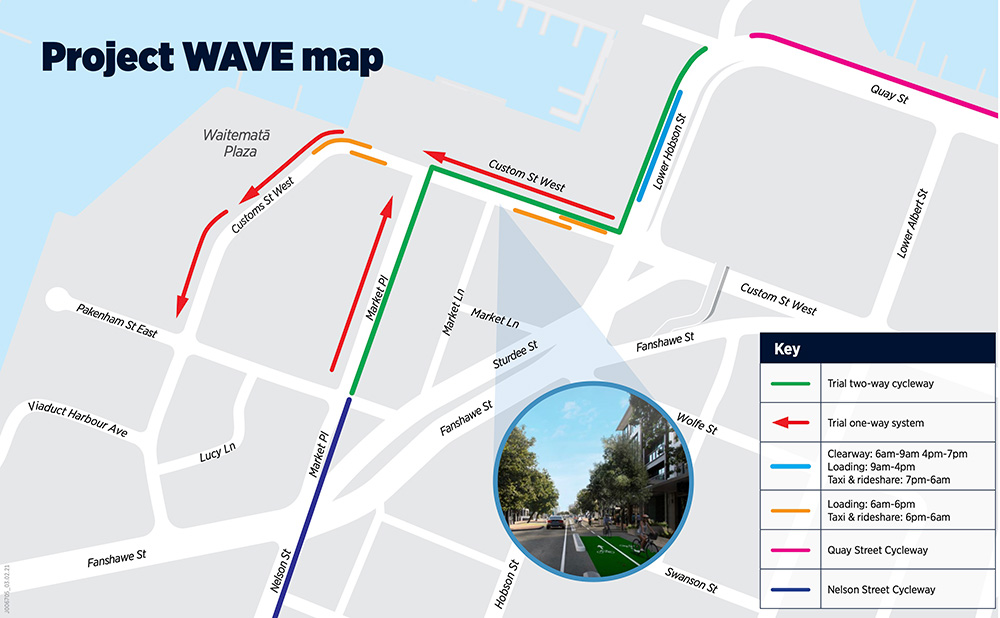
And here’s a map of the route
Just make it permanent already.
But no one cycles
Speaking of cycling, remember all those people saying that no one will cycle in Auckland.
Build it and they will come. Separated cycle paths along all arterial routes is the bare minimum we should expect from our transport authorities – and yes, they do get used. @BikeAKL #AKLBikeLife pic.twitter.com/jv0epeGZg1
— CriticalMassAKL (@CriticalMassAKL) April 13, 2021
Now imagine what the city would look like if we had safe routes all over.
Northern Corridor
Waka Kotahi have put out another video on the progress of the Northern Corridor project. The project isn’t due for completion till mid-late next year but you can see many parts of the busway extension are clearly in place
Another thing that stands from the video is how much empty land there still is around Albany. Albany has been planned for and under development for decades and is only 16km from the city centre and is still like this. Yet we’re expected to believe that it’s urgent we spend billions of dollars to support imminent development of places like Drury, that are 35km from the city centre.
![]()
Also, perhaps Kainga Ora should use it’s new land acquisition powers to buy the land and develop apartments.
Christchurch Southern Motorway
Another video from Waka Kotahi dropped this week and it really puts into question their claims about commitment to government priorities like addressing climate change. While the project is one initiated under the previous government, I wonder what they were thinking producing a video with people essentially gloating about how it’s increased the amount of travel they do, about how it’s made it easier for trucks to undermine rail on runs between the port and a rail connected inland port, along with other claims. While these are certainly side effects of the project, intentional or not, it seems an odd thing for them to create a video about when we need to be reducing the amount we travel.
Onehunga Low Traffic Neighbourhood
There was a good article by the Herald’s Simon Wilson this week about the Low Traffic Neighbourhood (LTN) trial in Onehunga.
There’s a bit of a battle going on in Onehunga, where several suburban side streets have been blocked to through traffic with heavy plywood boxes and artificial grass and patterns stencilled onto the asphalt.
Drivers used to rat-running on Arthur St, Grey St and some of the other streets nearby are now encouraged to use the main roads.
It’s a trial for a “Low Traffic Neighbourhood” (LTN), initiated and largely paid for by Waka Kotahi, the Government’s transport agency, with the support of Auckland Council and Auckland Transport.
Locals are divided. You’ve taken away our shortcut, say some commuting drivers.
Although that’s not quite what it sounds. There’s a pre-LTN video doing the rounds that shows 51 cars on Grey St, all in a line hoping to avoid the busyness of Mt Smart Rd. Not so much rat-running as rat blocked.
……
Most nights, says McGlashan, a few of the boxes get dragged aside. They’re filled with rocks and weigh a couple of tonnes, but they do seem to fill some people with rage.
And yet the battle shouldn’t be about whether drivers have all the rights to the roads.
Onehunga has good public transport, with a rail line and bus routes with frequent-service timetables. Many commuters who’ve had their old routines disrupted have real options.
And many locals love the intervention. There are two primary schools nearby and several pre-school centres, and the streets are safer for their kids. There’s great potential for games, barbecues and other events. The birds are coming back, as they did during lockdown.
/cloudfront-ap-southeast-2.images.arcpublishing.com/nzme/CG5EEVBUNSH4FWGMRCZPBEFP2I.jpg)
What’s odd is that LTNs get presented as something new but in many ways they’re returning to an old tool. Auckland already has many examples of where permanent changes were made to stop rat-running and this map by Tim highlights them.

Carrick Pl planted barrier to stop through traffic.
Over at another innovating streets project ….
There are two great things about this.
- It’s great to see schools and kids taking over the streets as part of another innovating streets project.
- It’s also great to see the minister commenting on it so positively. We’ve been really impressed by Michael Wood so far in his role as Transport Minister. He both ‘gets it’ and has communicated openly and transparently. If this continues, and there’s no reason to think it won’t, we’ll see significant positive change in transport in this country.
Changing the way our local streets work is one of the most challenging parts of our journey to give people real transport choices and decarbonise the transport system. It is great to see Innovating Streets giving local kids these opportunities and I'm keen to see more. https://t.co/Tii9cvMinp
— Michael Wood (@michaelwoodnz) April 15, 2021
That’s it for this week. Have a good weekend.

 Processing...
A LTN is currently being designed around my street in Glen Innes. Once it is implemented, it will be interesting to see if it generates as much media coverage as the Onehunga one. I went to the first consultation and Mr Mcglashan was great at addressing the concerns of the crowd
Sadly it won’t be a proper LTN I believe. It will be more traffic calming to address speeds on Eastview and remove the slip lane
Hopefully it will be better than nothing. The stats about average vehicle speeds on Apirana and Eastview were shocking
well keen to see our street in Panmure (Allenby Rd) given the treatment. Real rat run esp with the major busway works / new bridge causing big backlogs.
Fortunately my cycle commute time is completely unaffected….
I watched that Christchurch southern Motorway video. I get impression the managers at WK thinking great, a blast from the past. And I’m sure it achieved all the goals they care about.
Why the whole caboodle couldn’t have been built closer to Christchurch I have no idea. Same result, less kms travelled. I guess then it wouldn’t have counted as a satellite town, and they wouldn’t have got to build such a cool motorway
I got the impression it was more a trucking industry promotional video than WK doing a bit of back patting.
Had a bit of a giggle about the time saving it has created and wondered how long before all that saving will last for and the route become bogged down in traffic again.
There’s no accountability.
The CEO should be confronted with this. If she doesn’t understand the implications of road capacity expansion, her sustainability team need to keep her better informed. And if she sees a conflict between what the highways team and the sustainability team say, she needs to get advice from transport decarbonisation specialists.
Rolleston was created in the 1800s as it sits on poor soil, while it is surrounded by good quality soil. The purpose was to ensure the building didn’t happen on good productive land.
It really started taking off in the early 2000s though and accelerated even more after the earthquakes.
Yeah it was all brown fields when I was young but it’s amazing what a farmer can do with some irrigation and some fertiliser sort of like hydroponics in a way. But stoney ground the nitrates just go straight through to the water table. Also nitrogen oxides head into the atmosphere. The other thing is once they pay for the irrigation then you need to do dairy to get the returns to justify the outlay. You can grow grass year round if you have water. I have heard that dairy farmers could justify irrigation in regions that receive twice as much rainfall as Canterbury. Anyway probably best its used for housing and transport hubs rather than farming. And one day maybe every one will see the light and containers will travel there by rail the line can’t be to far away and I think there is an inland port there.
Using a phone while driving should come with demerit points. 35 each time. 3 strikes and you really are out.
Agree
It does, 20 demerit points.
Fair point.
It still should be raised though, the chances of getting caught 5 times in 2 years and losing your license is highly unlikely, whereas when you’ve got 35 points from the first fine the chances are higher you’ll sit up and take notice.
Eastern line cancelled again this morning due to line faults again. Fucken joke.
I am driving from next week.
Does anyone have suggestions for complaining about this ongoing debacle? Mayor? Minister? Writing to AT seems pointless…
And no info/updates….
Not very zen. Sorry, just had to say it.
Network fault, whatever that is, not sure if AT have used that term before. AT app had a notification at least 30 mins after the issue started affecting services, so at least 25 mins too late
I got a txt at 7:22 about a “network control issue” at Britomart, followed by a “Britomart has re-opened” txt at 7:44.
Ze Man , Have you ever tried KR as they collect millions every year from AT for them to use the rail , so don’t blame AT fpr the faults .
The cycleway looks good, but yes just do it now permanently. “Project Wave” what a load of bollocks there aren’t any waves in the viaduct anyway – is this meant to make us think it’s some amazing transformative project? It’s only a few hundred metres, should have taken a week to build sometime in 2017 surely
This looks to me that AT is simply taking the money from the Innovating Streets programme for a project they should be doing anyway. And that’s probably the whole reason for the cycleway delay. They just hate cycling so much they don’t want to spend money on it.
Does anyone know where the new ped crossings are going in on Project Wave? Can’t find any plans on the project site
Project WAVE (Westhaven And Viaduct Enhancements)
Originally the project had a broader scope, connecting over to the Westhaven boardwalk. Scope has shifted but the name remains
Very happy (well, kind of – given that the Customs St W calming measures are for what 2 months only). Bloody nightmare on the bike negotiating all the Uber drivers dawdling along and double parking outside HQ. Stuff em!!
OK, trolls? The idea of Tactical Urbanism has been strongly promoted here in the past, and well supported for Onehunga ETC. So what’s wrong with tackling an awkward join-up in the city centre with a trial that most of us expect will remain as permanent, but still capable of improving if there turn out to be any problems? Just try something could have been an idea two or three years ago, but it really is right for now.
That’s an interesting point. Things that have been hanging around for ages will tend to get this criticism, I guess, and AT deserves the public’s pretty low tolerance for cycling programme delays.
But AT certainly has the opportunity to lead a new approach to solving the city’s transport woes with a tactical programme. Indeed, if AT is embracing tactical urbanism, the draft RLTP could be improved remarkably.
And these words are hopeful:
“Should the results of consultation suggest the draft RLTP needs to be changed in a substantial way then we would need to discuss this with Auckland Council and Central Government.”
Agree, it would have been a good idea to try tactical approach 2-3 years ago and it still is now. You can hate on AT for taking so long do actually do it but that isn’t going to encourage them to do more of these types of trials. Much more likely for them to go “jeezz, even when we do the right thing people get annoyed”, let’s drop this complex retrofitting city building stuff and spend millions on sneaking through pseudo-motorways through out in the wop-wops.
Great to see Project Wave happening finally, it really shouldn’t need to be gold plated and a ‘temporary’ solution should be fine as long as it works.
As for Albany, why places like this aren’t getting more attention when it comes to intensification is beyond me.
100% no fancy expensive solutions are needed.
The 30kmh streets around the Viaduct need to be re-routed into a one-way type system, that way loading and some parking can still be had on one side of the road, and the other can be used for a separated cycle path.
Speed cameras to enforce the 30kmh are needed there too + more zebra crossings.
Mobile phone use at the wheel is absolutely rife. Walk, cycle or ride a motorbike and you’ll see the steady glow of the phone in use, in motion.
Australia has been using automatic cameras for mobile phone detection. The technology works and enforcement is rigorous. Let’s import this system and use it in New Zealand.
https://www.abc.net.au/news/2021-02-22/mobile-phone-detection-cameras-nab-thousands-of-nsw-drivers/13173522
intersting stats from that article!
During a six-month trial of the technology in Sydney in 2019, Transport for NSW found one in every 82 drivers were detected using their phones illegally.
Between March 2020 and January 31, 2021, the offending rated had dropped to an average of around one in every 453 drivers caught holding their phones across the state.
Mobile phone distraction is rife, full stop.
I’m tired of zombies not watching where they’re walking and almost walking into me, or cutting me off.
It’s even worse when you’ve got a wall on one side (and you’re up against it) and a zombie looks at you aggressively for not moving for them, when they’re the ones who zig-zagged across the entire width of the path.
We should get those cameras for sure, but we need more social intervention to reduce how many zombies there are full stop.
To use your analogy and take it a bit further, I agree, while a zombie on the footpath is a bit frustrating, a zombie behind the wheel of car / van / truck can cause a lot more damage.
I was nearly crashed into on the M25 on Friday by a woman face-timing with a large iPad while driving near Watford.
It’s an issue world wide.
$150 for using your phone is a joke. It should be an instant driving ban. When will Police create an online portal for uploading videos like he UK does, so people can report dodgy driving
As a kiwi who drives a lot in the UK, that scheme does not work.
It might be 35km vs 16km, but Drury is (a) 16-ish km to Manukau and (b) 35-65 minutes to Britomart by car vs 45 minutes from Albany and (c) 82 minutes to Britomart by PT, pre railway stations, versus 58-64 minutes from Albany. (via Google Maps)
To be perfectly honest, if you live near Papakura, unless you work or study in Central Auckland it’s probably basically irrelevant to your life. According to https://commuter.waka.app/ Papakura and Surrounds (so, that includes Drury) has about 1227 people who /work/ in Auckland Central (incl. Newmarket), which is less than the 1569 (7%) who work in East Tamaki (for those who are interested it’s also less than the 1359 who work in the Auckland Airport, I think these are, statistical area). In contrast, the same area of Auckland Central gets 2001 workers from the statistical areas adjacent to statistical areas called Albany (I’m not sure what exactly counts as Albany), which is well more than the 651 (6%) who work in Wairau Valley.
Of course, the real headline is that we’ve got 2001 out of the 5934 (48%) Albanites leaving Albany to go to Auckland Central, i.e. about 34% of those that leave. In Papakura, that’s 1227 out of 13050 (61%), i.e. about 9.5% of those that leave.
If we look just at Karaka-Kingseat, Dury and Drury Rural Statistical Areas then we get 1590 (60%) departures, East Tamaki is still the mode (but at 5% not 7%) destination and 174 people to central Auckland, which is about 11% (not 9.5%).
With the education flows, for the 28 statistical areas I say count as Papakura and surrounds, 2130 (24%) leave the area and 759 (9%) of those go to the Auckland University statistical area. In contrast, Albany has 8097 resident students (about 5000 fewer) and 2778 (43%) depart. “Auckland University” still gets the most, though, at 768. The bigger difference though is that there are way fewer people from Albany (as I defined it) that go to King’s and so on.
Obviously we can’t assume the mass expansions in Drury won’t change the commuter patterns for work and study (and also other changes along the lines of working at home), but there’s just no comparison to be made between Albany. Indeed, even though they’re almost equally far away on a duration of journey basis, it appears that Albany is practically a satellite of Auckland Central work wise whereas Papakura in general and Drury specifically are very much not.
I don’t know if Auranga and Drury West are really needed, but you can’t show that they’re not by looking Albany, which may as well be part of entirely different city.
You mention distance to Manukau, but you are forgetting that you have to compare it to distance to other regional centres — like Albany. If those paddocks in Albany get developed they will have a regional centre within 0 km rather than 16 km.
That’s not relevant to the point I’m making or, rather, the point being made by Matt, which was that Albany is still sitting empty so why develop Drury which is much further away from central Auckland? The problem with that logic is that Drury and the wider area it’s part of *don’t* use central Auckland /now/. That’s all I’m saying.
That being said, if Albany mattered, it would already be built up.
Like, the only places where there’s that much open land in the most southern parts of suburban South Auckland are farms or Defence Land… the development between the Great South Road and Bruce Pulman Park has filled in a lot in the last five years. The golf courses are being ripped out and the far end of Park Estate Road is under development. I guess it’s always possible that the roads could be laid down and nothing happens but who knows.
GA goes on about Drury a lot but at the moment there are a lot of big developments going on in the area:
* Manukau Golf Course (despite the name, this is situated between Takanini and Manurewa)
* Park Estate Road
* Auranga (aka Drury West)
* Drury South Crossing
* the land between Takanini Warehouse and Takaanini Train Station… I think that’s still part of Addison
* all these houses between Cosgrave Road and Walters Road… though this may still be part of Addison
* there’s 7 hectares going in off Dominion Road (Papakura version)
* Harbour View Heights (off Settlement Road, sort of)
* 4 hectares off Opaheke Road
I think the post’s included a picture of Don McKinnon Drive, which Google Maps tells me is about 19 hectares. To put that into perspective, Park Estate Road is 31 hectares just going off the brown discolouration on satellite view.
Another way of looking at it, the sprawl that linked Drury to Papakura in a contiguous fashion a few years back was 13 hectares. And there’s 30 hectares of development off the eastern end of Old Wairoa Road that went in recently ish… I’m not sure when. I think it started in 2014 or 2015. In any case, the roads don’t appear on the “Recommendations Zoning Maps” maps found by going to council’s “History and earlier versions of the Auckland Unitary Plan” page. In contrast, Elliot Rose Avenue and the other streets laid out with no development off Don McKinnon Drive in Albany do.
The point I’m making is… Albany isn’t like southern South Auckland. If you want to take that 0km logic, those houses should already exist. There shouldn’t be roads laid out who knows how many years ago, that a just sitting empty. I don’t know why this is the case, but it doesn’t happen like this round here. They put down the roads and they manage to sell the land and build the houses. Despite being further away from central Auckland or a sub-centre (like Albany supposedly is), than those empty roads in Don McKinnon Drive.
As I said, Albany may well be in another city.
*Sprawl has been contiguous down the Great South Road, albeit only on one side between Gatland Road and Park Estate Road, since about 2012/13… rendering Drury Village less a village surrounded by working land in all directions and more just another suburb of Papakura.
Probably there are more jobs in the south than at Albany.
Good about the fine increase. Now for the other parking and bike lane ones with some better enforcement. So many sloppy parkers out there they don’t think or care where they park.
I think trialing the Nelson to Quay st/Viaduct area could be good thing particularly regarding loading zone impacts.
Everything else interesting too.