Auckland Transport are consulting on what, if fully delivered, will be an exciting, safe cycle network for Henderson. This follows a consultation in 2018 where they asked where improvements should be made. They say they had 500 submissions on that with 275 new routes identified and that since then they’ve undertaken “further technical work” to narrow down the key routes of the proposed network. I wish it hadn’t taken two years to do that though. Firstly their objectives
Our aim is to progressively build a cycle network that caters for people of all ages and abilities.
We want to make it easier and safer for people to get to, from, and around Henderson by bike.
Henderson already has some good routes for recreational cycling, and we want to build on this to create a network of cycling facilities that are focussed on making it easier to get to work and school and make everyday trips.The Henderson-Massey Local Board also shares this aspiration to make Henderson easier to get around without the use of a private vehicle.
And the detail about the consultation.
The proposed cycle network in Henderson will provide better connections and help people travel around Henderson by bike more easily and safely.
It’s aimed at helping people get about for transport rather than for recreation, however these links will likely be used by people for a variety of different purposes.
The intention is to develop a comprehensive network for cycling that can be built over time, as funding becomes available.
We have identified 8 key cycling routes that will form the backbone of the Henderson Cycle Network. Once the network is confirmed we will look at how best to connect the routes into the surrounding neighbourhoods.
At this stage we are not yet considering the design of these routes, however they would generally be separated from traffic and pedestrians following vision zero principles. Following this consultation further work will be done on the designs.
The proposed routes are:
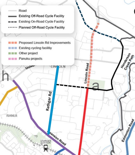
- Lincoln Road to Town Centre – proposed along the southern half of Lincoln Road which will connect to the planned Lincoln Road Corridor Improvements between Te Pai Place and State Highway 16 (SH16) Interchange.
- Te Atatu to Town Centre – proposed along Edmonton Road to connect with the existing facilities from the School Road intersection and along Te Atatu Road towards the Northwestern Cycleway.
McLeod Road to Town Centre – proposed along the length of McLeod Road to connect with the planned Te Whau Pathway.- Great North Road – proposed along Great North Road from the Swanson Road/Lincoln Road intersection towards the City Centre as part of the Connected Communities programme. The section through the Town Centre to Swanson Road will be delivered as part of this project.
- Henderson Valley Road to Town Centre – proposed along a section of Henderson Valley Road which will connect to Panuku’s planned improvements close to Great North Road.
- Western Heights to Swanson Road – proposed along Sturges Road. Will provide easy bike ride to Sturges Road Station and the proposed route along Swanson Road towards the town centre.
- Metcalfe Road to Swanson – proposed along Metcalfe Road. Will provide easy bike ride to Ranui Station and the proposed route along Swanson Road towards the town centre.
- Swanson Road to Town Centre – proposed along Swanson Road to connect with the proposed routes on Metcalfe Road, Sturges Road, Lincoln Road, and Great North Road.

Firstly, it’s great to see AT presenting this as somewhat of a cohesive network. If they deliver every route they’ve identified it will be a huge improvement to the area. Combined with the existing recreational routes and the Te Whau Pathway it would help make the area one of the best bike connected areas in Auckland.
In terms of these routes they’ve selected, these are all logical routes to pick and all are very much needed, The biggest omission here is Rathgar Rd (to the west of and parallel to Lincoln Rd). AT originally approved building cycle lanes along it in the 2011/12 financial year and never did. What makes Rathgar so important to be included is:
- there are three schools within 500m of each other along the road and provides connections to at least two others on roads off Rathgar.
- the Sturges Rd train station is close to the southern end so it would provide for more trips to public transport (note for AT, the station symbol is about 400m west of the actual station location).
- there are also some existing on-road and shared path facilities they’re missing from their map that connect to it (Pomaria Rd and Te Pai Pl).
The network however, is very radial and it feels like it needs better connections between some of the routes. For example, Te Atatu Rd from Edmonton Rd to Gt North Rd.
Another is Munroe Rd/Summerland Dr which has a school halfway along it and another one close to the southern end on Sturges. It also has the Ranui train station at the northern end, again for the bike to PT tie in options. And then there already exist a few of these bike bypasses of pedestrian refuge.

There are I’m sure many other additions I’m sure locals would love to see. Perhaps my biggest concern is how long it will take to see them. AT say we won’t see any construction until at least 2024 and given AT’s history with cycle projects, it could take years long to actually deliver them. As someone who lives in the area and who would make use of this a lot, I really hope they deliver this, we need them already. We also need this in every other suburb all over Auckland.
Consultation closes at the end of the month on 31 January. There is also a drop-in session
- 23 January 2021, 11am to 2pm – Community space inside West City Waitakere – 7 Catherine Street, Henderson, Auckland.

 Processing...
“ AT say we won’t see any construction until at least 2024 ” !! Wow, confidence in this being delivered has plummeted.
Although this is exactly what’s needed, an area that’s fully connected so that people will eventually see what they’re missing out on.
Is it a funding thing or does it take that long to consult and design?
Are the government funding cycling infrastructure? If not, why not, considering even National did so?
If they are funding it why does it take so long to design?
Personally I think AT need to be somehow privatised. No private company would piss around for at least 3 years like that.
AT may choose to do consultation on concepts for each route. Then they will still need to design all of these routes (transport and urban/place design and then actual construction design), then do consultation in order to create the bylaws required for cycle lanes or cycle paths. Starting a programme this big in about three years is about standard.
It may be standard in Auckland.
What has become best practice overseas is very different. We have to get faster at this.
Actual physical works construction is not any faster overseas or in the rest of New Zealand and we will need actual physical works at intersections on these routes, especially as they are all still going to be important links for traffic and buses.
AT definitely could do interim works, but would then have to do two rounds of consultation for changes to bylaws within two years of each other, which the public *hate* for any project.
Yeah, so firstly we need some basic principles of intersection reallocation established – responding to our safety crisis and climate emergency, and consciously overturning established practice – so that what the designers (are often forced to) produce in the first place isn’t so compromised.
Secondly we need central and local government to work together on changes to the bylaw process so that it’s not so cumbersome.
Thirdly we need changes to the consultation so we use deliberative democracy at a city-wide scale, followed by local consultation that can draw together local considerations but not overturn city-wide direction from the deliberative democratic stage. And at every stage we need to mitigate the tendency for design, consultation and political response to listen to and support the voices of the status quo.
I completely agree with you. Sadly, those changes aren’t going to come in before 2024 even if government starts on them now :/
I’d like to see more direct connections with Sturges Road station in the area too. Just because it has a park and ride doesn’t mean it’s the only way people will access the station. The walkways on the opposite side aren’t somewhere I’d probably want to walk after dark either. There’s a stack of development happening on Swanson Road and walking/cycling access to Sturges Rd station needs to be a priority for the area.
The walkways on which other side, do you mean down towards Neta Grove? If so, whyn do you think it’s unsafe? It happens to be the way I go so I know it well.
From memory the last time I was there it didn’t look particularly well lit but I’m not a frequent user – so may just have a temporary issue with the lights?
Possibly. I don’t have any issues with it but then I’m also a guy so appreciate there’s less risk for me than others and not everyone will feel the same.
In a way I quite like that the houses are quite close to the street as feels like if something were to happen you’re more likely to get support.
AT must stop encouraging hugely expensive sprawl. The cost to families, businesses, farmland, congestion, councils and emissions is high.
For NZ to be competitive in the world we must consider the cost/benefit of projects and that includes low cost bikeways
This is an area I know well. Before I retired I would often walk it in the early morning.
I am also interested as to safety?
Urgh still no cycleway on Universal Drive and Swanson Road connecting to the NW path. Nothing for Swanson as per usual.
For an indication of how long any of these might take….. https://at.govt.nz/projects-roadworks/new-lynn-to-avondale-shared-path/
Following the railway tracks implies a good grade for cycling, is completely off road and is free of driveway dangers, etc.
I’d like to see this New Lynn path extended to at least the Oratia stream path, or Henderson.
I guess my question is whether the best strategy is to retrofit expensive new facilities to busy and low amenity roads like Lincoln and Te Atatu, or to develop alternative routes in quieter streets.
For example, I sometimes bike to work at Waitakere Hospital from the City. I would far rather see the formalisation of the already partially existing connections between the NW cycleway and the Central Park – Te Pai – Waipareira – Woodford route. Currently there’s an offroad bike route on Central Park Rd which just… peters out. I have no wish to cycle down Lincoln Rd if I can avoid it – even with bike lanes.
There are many other examples of non-radial and non-arterial road improvements needed – for instance improvements to connectivity across Henderson Creek are badly needed – the Central Park bridge is not cycle friendly at all.
There’s loads of amenity on Lincoln Rd, there’s at least 50 takeaway outlets to start with.
+1, there are hundreds of businesses on Lincoln Road. People buy things from these businesses, work at these businesses, sell hings to these businesses. People need to be able to get there by cycling. Further, Lincoln Road is straight and flat. It’s the obvious choice for the major cycle route north-south in the area.
I’ve ridden on the section of Lincoln Rd south of Pomaria/Te Pai before and if it wasn’t for the lack of a cycleway, it’s actually not to bad. In fact the auto-dependant design of the shops, often with shops far from the street makes the bike work better than walking and even driving as faster to move between shops. It definitely needs a safe cycleway
Any work is so far off it makes it so hard for me to get enthused about submitting. I’d like to see the whole of Te Atatu Road (Edmonton to McLeod) included as a cross connection. It’s flat being the ridge line and already wide so seems to have the space (the on street parking is seldom used).
Still worth submitting even if to say “great go ahead”. There is always the opposite opinion to off-set.
Not sure why there is all the talk here about “creating bylaws” or “changing bylaws” as if that was a big concern with this one. That is not how the law works for these matters in Auckland. The Auckland Transport Traffic Bylaw 2012 is actually a pretty agile and accommodating legislative instrument. Traffic controls for cycle lanes, cycle paths and shared paths are all matters that the Bylaw allows for without needing any amendment to the Bylaw through the burdensome Bylaw making process (ie like what had to be done for the speed limits). The Bylaw allows for these types of traffic control to be created by way of a resolution passed under the Bylaw that sets out the location and details. The power to resolve these sorts of decisions (and most other parking and traffic control decisions) is delegated to the Traffic Control Committee which meets fortnightly.
There is obviously the need for a bit of legalistic bureaucracy around this to ensure that public funds are spent in accordance with the law and that proposals have gone through the necessary engagement and review processes, but this is nothing like the over the top process that had to be used to do the speed limits or something like a pedestrian mall.
So the Bylaw is not going to be the hold up here. It is more likely going to be the design process and dealing with the consultation backlash once people are told they are not going to be allowed to use some of the public road space to store their privately owned property for free (on-street parking as it is often called).
And yeah there will probably also be funding issues that need to be sorted out because, … well, … covid. Sigh
Is there not still a legal requirement to undertake consultation before amending the bylaw? That will take time and design often goes onto a soft pause during consultation to avoid any rework.
That’s the point; you’re not amending the Bylaw; you’re just updating the accompanying Schedule of sites – no full consultative process required.
Worth noting this is not the first round of consultation for Henderson, people were asked a number of years ago if they wanted better facilities for walking and riding- the answer was yes. Maybe this is refinement of routes but still seems to be taking forever.
Any plans to extend the shared path along the NW Line all the way to Swanson?
Anything that extends the existing network or connects to a major train station and/or the northwestern is a good idea. This is what AT should be doing, instead of that isolated nonsense in Mangere.
3 years is a long time to wait until construction. I assume they will start initial design work in 2021, consultation 2022, surely they can start construction in 2023 unless there are funding issues. But I guess it depends if they have to buy land to widen the road to fit stuff in.
Yeah except its more like 6 years. They started first wave of consultation on this in 2018.