As I mentioned yesterday in my look ahead, if it sticks to the timetable laid out in the NZ Upgrade Programme (NZUP), Penlink is due to start construction later this year. But a question that is going to continue to swirl around the project is if it should be two or four lanes wide. When announced as part of the NZUP, and confirmed by Waka Kotahi less than a month ago, Penlink will be a 7km tolled two-lane highway and is expected to cost $411 million. There will also be a walking and cycling path alongside it.

However, locals are keen for a four-lane highway such as in this article running with the classic Harbour Bridge analogy:
The Government and Waka Kotahi NZ Transport Agency are being accused of repeating the blunder of the Auckland Harbour Bridge by fixing one of the city’s worst bottlenecks with a two-lane highway.
It is also suggests that “surely common sense demands a four-lane road” and many on the likes of local facebook pages four lanes is the “smart thing to do“. But as can often be the case, “common sense” often isn’t all that sensible.
To assess if they’re right, we first need to answer two questions
- Does Penlink need to be four lanes, now or in the future
- If the answer to #1 is yes, should we build all four lanes now.
So let’s look at those and to start with, let’s look at how many people might use the road.
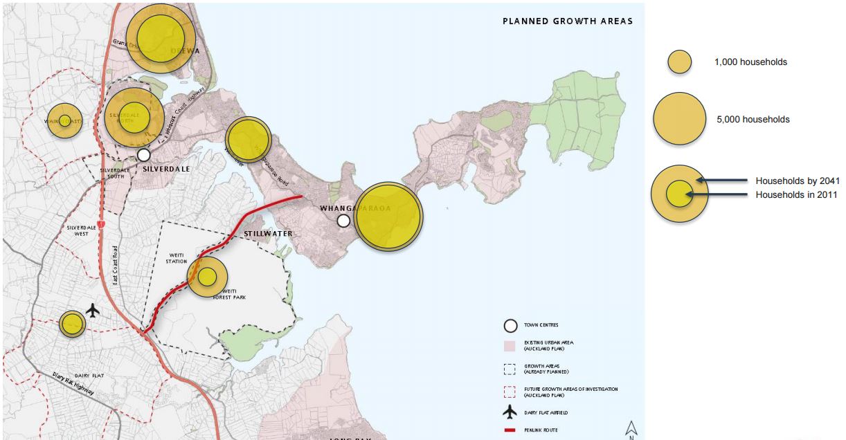
The main users will be those living east of where Penlink joins into Whangaparaoa Rd and can be represented by the Statistical Area Units in the map below. Combined, these areas have an population of just over 26,000 people.

The population has grown from about 16,000 people 20 years ago through relatively sustained growth, however, there is good reason to believe that the area won’t see substantially more growth in the coming years. Firstly, much of the peninsula is already developed. There will still be pockets of development but not likely anything on a large scale. Secondly, the Unitary Plan locks in low growth, primarily by only allowing for single houses to be built, thereby preventing the development of townhouses and apartments.

Of note, the main justification given for Penlink is not about growth on the peninsula but that it takes peninsula traffic off the Silverdale Interchange to give space for all the vehicles that will use it from the nearby new greenfield areas.
Penlink will take congestion pressure off the Silverdale interchange, Hibiscus Coast Highway and Whangaparāoa Road. The new transport link will also provide greater capacity, supporting planned growth in Silverdale, Wainui, Dairy Flat and the wider Hibiscus Coast in the next three decades.
This is somewhat highlighted by these images from a presentation a few years ago before the current extent of the greenfield growth areas was made clear. They show the scale of household and employment growth which is fairly small in the area for the area that benefits from Penlink.

Let’s now break down that population a bit further. Of the 26,000 people living in the area, about 6,600 are under the age of 20 and another 4,500 are 65 or older. These two groups are the ones who will not be driving or unlikely to be driving at peak times. That leaves about 15,000 people between the ages of 20 and 65 and notably a third of this group are 50-64 years old and so will fall into the retired category in the not too distant future. But not all of these people will be working/travelling or more importantly, not be travelling to Albany or further south at peak times which is the crucial thing needed to understand the two or four lane question.

Next we can look at Stats NZ’s Commuter Waka which uses the journey to work and education questions from the census to see where and how people travelled. The data isn’t perfect but it is useful to get an indication of travel so we can see for example, how many are travelling to places like Silverdale compared to how many are travelling to Albany or further south.
Looking just at the journey to work data it tells us just over 3,000 people who live in the areas below in green, also worked there, including at home. Meanwhile about 5,400 left to one of the areas in various shades of red. Of those, 1,600 of those were the areas around Silverdale and Orewa, for which Penlink won’t be of any use, leaving just 3,800 heading south and not all of them are driving.

What this suggests is that even if we scale up the numbers a bit, we’re probably looking at 5-7k per day that might use Penlink but
- not all of those will travel at peak
- some will be put off by the toll
- likely an increasing amount will catch a bus or ferry (currently around 9%).
This happens to be not too dissimilar modelling done in the past for the project, which suggests two-way volumes of 12-17k per day in a situation where the road is tolled. The modelling also suggests peak hour flows of about 1,200 per hour, well within the capacity of a two-lane road.
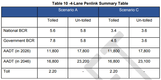
In the table above, scenario A & C relate to whether SH1 is widened or not but it makes little difference. However, it is another important point and still the biggest issue with Penlink in general. The motorway north of Albany is only four-lanes wide, two each way. Yet the motorway south of Albany is frequently congested. Penlink doesn’t do much other than just get a few cars to the congestion point a little bit faster. If anything, building Penlink as a four-lane road it would likely just make this worse.
Perhaps the one thing we may want extra lanes for, and they likely only need to be at the ends, is likely to be for bus priority. Auckland Transport’s Regional Public Transport Plan suggests that once Penlink is complete that they’ll extend some NX2 services to a new Whangaparaoa Station. On its own this would likely help encourage use but could also become part of longer-term strategies to encourage mode shift.
All of this suggests that if tolled, like the government have said it will be, a two-lane road is more than sufficient to handle expected volumes for the foreseeable future. It also means there’s no need to answer the second question I posed. If they still really want a four-lane road then perhaps one thing they should do is start by getting together to call for more housing in the area by upzoning the peninsula.

 Processing...
Would putting in bus lanes and weird station with a link to the busway make any sense at this time?
That would be really weird although it might work.
2lanes for general traffic max or 3 lanes with a dynamic bus lane. 4 lanes would be pointless and inconsistent with desired policy and climate outcomes.
How would use describe a dynamic bus lane on the Penlink?
Correction: How would you describe a dynamic bus lane on the Penlink?
I think all that would be needed would be a bus lane at either end where queuing might happen. The route is unlikely to be congested the whole length given it is a toll road.
Expect huge development pressure on Weiti and Okura afterwards, won’t be too long until that is zone changed.
That would not require 4 lanes all the way still. The weiti river bridge and a decent amount of road south of that would still only need to be 2 lanes. Large sections of these areas wouldn’t need to use the pen link road. And if we were to continue with more serious car development then an additional interchange on sh1 would be built north of penlinks.
“likely an increasing amount will catch a bus or ferry (currently around 9%).”
It would be strange if that comes about as a result of this road. Planning for speed and distance (ie building roads to improve travel times for people taking long commuting trips) typically increases the driving of the people in the outer areas and decreases the driving of the people in the inner areas who get swamped by it. Overall, there’s increased driving and emissions.
If this road is any different it’ll only be because putting the traffic onto SH1 is such a clustershambles that it somehow doesn’t offer a better driving experience. A lot of money to either succeed at growing emissions or fail at improving driving.
Our C40 membership hanging by a thread. This is transport planning at its worst.
Heidi
surely any belief that you might have that any of our transport planning is done with reducing emissions in mind must be “hanging on by a thread?”
I am going to write a letter to the C40 cities organisation asking they discontinue our membership. It’s just way too embarrassing – and that we were seen as an innovator city, unbelievable.
How do you think we’ll fare on this new leadership requirement?
https://www.c40.org/blog_posts/statement-by-the-c40-cities-steering-committee
Heidi
Realistically Auckland is only on track to achieve number 1; and let’s face it anyone with even a pencil, or a crayon can trace a plan.
If it is going to be a four lane highway, then two of them should be bus/transit lanes.
Otherwise keep it at two lane with future proofing.
This is just shifting the queue to a different location.
There won’t be a huge increase in population in that area.
1 lane each way will be fine for 95% of the day. As long as it comes with good walking/cycling connections, no point spending more than necessary.
Building a 2 lane road now does not preclude it being widened to 4 lanes in the future, just build another bridge as has been done at Mangere and Upper Harbour. I’ve never heard anyone talking about the Mangere or Upper Harbour debacles.
I used to live in Stanmore Bay and so have been following progress of Penlink with interest.
I used to cycle from Stanmore Bay to work on the Shore occasionally, but it was hard work – cycling back around Silverdale then climbing up and down through East Coast road hills. I dreamed of having a way of cycling directly to the East Coast Bay road.
Unfortunately, 8 years on from when I moved out of Whangaparaoa to live much closer to work and schools (a move which has worked out very well), I don’t think I would lightly cycle East Coast road these days. Traffic moves at 100kmh+ on a road that barely has shoulders, much less cycle paths despite being the only viable option to get north/south east of the motorway.
So I am really hoping that any attempts to put walking/cycling path on the bridge is joined up with better infrastructure for when cyclists are dumped into a fast moving dangerous road.
I had though Gulf Harbour might have been a popular retirement location, but last time I was there, it seemed quite dead with house prices relatively low. Difficulty of access I guess. Not checked it out, but been told that the ferry is relatively expensive to do daily , so people drive . which is very time consuming, and will be for years despite the Penlink go ahead.
While an argument can be used for building only 2 lanes all of the analysis particularly in the 2019 business case points to being false economy. Building 2 lanes $411million then adding that figure again in a few years is absurd. Doing it once doing it properly is the correct scenario. We can argue many things but the way Hibiscus Coast highway and Whangaparaoa road works now is not acceptable. We talk about peak hour traffic but want to use the road on a weekend it is just as bad. The economic benefits to our local business’s is also important. Many business’s can’t get deliveries in peak time costing the customer more in time wasted receiving goods. To introduce demand management i.e. increase the Toll when Penlink gets busy is unfair. Where else in the Auckland region in fact the whole of NZ does this happen. The cost to widen Whangaparaoa road for efficient PT is huge so why not put the 2 lanes dedicated to PT on Penlink. The BC ratings Table 9: BCR comparison for two and four lane options 2019 business case
BCR Two lanes Four lanes
BCRN 6.8 – 7.8 4.8 – 5.6
BCRG 11.4 – 13.4 6.6 – 7.8
far outweigh any other transport project in NZ. The BC rating for the Puhoi to Warkworth rating is less then 1 this tells a story on its own. Some Private investors are and have been keen to invest in the 4 lane Penlink so if the Government can’t/won’t then let them do it!!!
What is unfair is continuing to build roads for people to drive long distances when we know that driving is causing climate change and putting people who are trying to travel sustainably (walking, cycling, walking to the bus) at risk of traffic trauma, and keeping people unhealthy from physical inactivity.
This is why we have a climate emergency and a safety crisis. Pandering to speed and distance instead of caring about people and environment.
Whangaparaoa doesn’t have basic infrastructure. Footpaths to bus stops. Pedestrian crossings. Safe cycle lanes. Bus priority. Campaign for those things, please.
This boondoggle of a new road is a climate crime. It’s taking money needed for regenerating our city into a liveable place.
The local board, despite media attention, has never put a single credible ‘private investment’ business case into the public arena. It’s pie in the sky thinking.
As for the business case, the data used to calculate the BCR is completely flawed. As per the continued downscaling of The Plaza, the notion that the area east of Penlink is to be an area of great employment is completely theoretical and extremely unlikely to happen. The local employment growth area is Silverdale.
Did you read the post above?
https://www.aucklandchamber.co.nz/media/chamber-media-releases/new-penlink-business-case-reinforces-case-for-immediate-action-so-why-the-delay/
The 2 lane BCR is vastly better.
And thats the point as the post above, you will not have to “build that again a few years later”. There is severely limited growth potential on the peninsula, connecting to SH1 at Albany will bottleneck it all regardless, and massively upzoing an area so far from the major employment centers doesn’t make any sense either. That 2 lane bridge and road is all that’s needed for the future. Perhaps some could be double lanes, getting close to the southern interchange with SH1 should have bus lanes on the sides, but not the entire thing.
I agree that it should be built. But not a 4 lane white elephant.
FFS, we have declared a climate emergency. Let’s build a two lane busway with cycle lanes either side and leave it at that. Why on earth would we want to take measures which would exacerbate the biggest problem that the planet faces? Let’s plan for a Whangaparaoa Peninsula where the preferred travel modes are public transport, cycling and walking. THAT would be the most positive thing we could do.
Agree entirely.
Does anyone seriously think for a minute that a 4 lane Penlink with 2 of the 4 lanes set aside for T2/T3/cycling and buses will be in any way acceptable to those paying to drive over said toll road?
They’ll argue that they shouldn’t be paying for the increased costs of a 4 lane option over the 2 lane option in the guide of “fairness”.
Simple common sense suggests that we don’t even go there.
Build the PT and cycling bridge and pay for it out of NZTA funds.
Yes and there is surely no call for adding yet more road lanes when they haven’t first put cycling and bus priority on the existing road?
Don’t build it at all, build a Busway instead. More roads is only encouraging more car dependance
“Some Private investors are and have been keen to invest in the 4 lane Penlink”
Really? With a toll of $2.20 per day?
Using Matt’s most optimistic traffic flow of 7000 cars per day that’s a daily return of $15,400 or $5.62 million per year gross. (how much will be lost in admin charges?)
That won’t even pay the interest on $411 million for the current project, let alone anything else.
I do think though that it would be a great idea that all roads should pay for themselves and be charged, We may then have a situation like Japan and Italy where the true price of roads causes people to travel using other modes. NZ may then start to make some progress on reducing transport emissions.
It’s bullshit. Not a single credible proposal has ever seen the light of day.
True. I think the technology now exists to allow us to charge road users for their road use, based on normal commercial precepts – it costs more when the road is busier, or for heavier vehicles that cause more wear and tear.
If railways were charged on the same basis (and equally open to multiple users) I wonder how that would change the transport balance?
Easily taken care of – Just reroute SH1 over Penlink and the toll returns will go through the roof!
The ferry fare is $11.10 with hop card one way. Too expensive to attract much patronage. We could subsise it more to save needing 4 lanes. Also convert to batteries to avoid emissions. Could it stop at Takapuna.
The Takapuna ferry stop has always intrigued me. We would have to build out a decent breakwater I believe so I don’t think it would ever get consent.
Make it Light Rail only 😀
LOL!
I did think of that but seeing the ocean is right there and is free to use a ferry seems a better bet.
When the time comes to apply for consent for this road, how will greenhouse gas emissions be addressed? This will be an issue for this and all similar projects now that greenhouse gas emissions once again count as an “effect of the proposed activity”. https://www.newsroom.co.nz/build-homes-not-airports-and-expressways
I think it already has consent?
“how will greenhouse gas emissions be addressed”.
In the 2013 business case they gave this bullshit: “Air quality can affect public health and is significantly impacted by vehicle traffic. Congestion results in a higher concentration of emissions within a particular area. By creating an alternative road to facilitate growth, the total traffic journeys are likely to increase. However, the concentrations of emissions are likely to decrease, due to faster travelling speeds and the split of emissions across two separate roads. This will likely reduce the air quality impacts and increase the quality of life for the local Whangaparaoa community… The Project contributes to meeting the strategic objectives of AT, project objectives and wider objectives of relevant documents. Penlink will:… As a result of the reduction in travel distances and traffic congestion, lessening air pollution (with lower CO2 emissions and other pollutants due to less engine idling time).”
As I’m sure you’re aware, Robert, this has been debunked over and over. Building roads increases emissions. https://cityobservatory.org/urban-myth-busting_idling_carbon/
As for the latest business case, where is it? Why did AT get it done? Anything to do with the local political pressure to try to push it up the list?
What I do know is that what seems like an ‘improvement’ – putting a higher carbon price on these roads – is actually further manipulation of the data to support road building, because they still claim there are emissions reduction benefits.
The roading barons in WK need to be stripped of their power.
Penlink is different. Most roads getting built today already have some other road along that route (or really similar), or are not the shortest route actually making a detour compared the old road. This is not the case with penlink. It is significantly shorter. A car going on penlink will emit less c02 for that trip compared to the same car going the long way round through Silverdale. The road is also further away from people on average, so that’s another one in its favor. Although c02 doesn’t really care where its emitted from the warming perspective.
I agree that the decreasing idling argument is silly, that is a surefire way to tell there is suppressed demand which will eat any c02 savings from trip time
This only question is how much this build will increase driving, off setting the other 2 points. And how well implemented the cycling and bus modes using this corridor will be, helping offset it too.
Most roads don’t have a pollution leg to stand on, but I think this has a chance to.
Yes I accept that difference. However, building a new road through coastal environments should ring warning bells – have the proper considerations been made? In this case, no.
There is an intervention hierarchy that investment is supposed to follow.
First, there should be integrated planning. “Align development with existing transport infrastructure and services, and plan for urban form which reduces travel demand.” This hasn’t happened; Whangaparaoa and Silverdale, and further north shouldn’t be being developed.
Next, there should be demand management. “Address demand through supply-side measures: active modes, public transport and school or workplace travel plans.” This hasn’t happened. There isn’t even basic stuff, like footpaths, let alone cyclelanes to bus stops, lower fares and more frequent services, bike storage etc.
Third, the best use should be made of the existing network. “Through optimised levels of service on roads and public transport services.” This hasn’t happened.
Only after all these things have been done should anyone be looking at new infrastructure.
See: https://www.nzta.govt.nz/assets/resources/The-Business-Case-Approach/PBC-intervention-hierarchy.pdf
This is just yet more infrastructure that our kids will have to maintain even as they’re trying to pay for carbon credits, cope with their own pandemics and wildfires and droughts.
This road got into NZUP because local pressure had elevated it and the road builders love a good new road. Not because it is worthy. It’s not.
If potential congestion in future is the basis for more lanes, then two of them must be for buses 24/7. Bus lanes will do more to ease any future congestion in the long run than additional lanes ever will. It could even be an LRT spur in future.
Either its a problem and you need a sustainable solution, or its not such a problem at all. Two lanes only for cars, whatever your position.
“This is just yet more infrastructure that our kids will have to maintain even as they’re trying to pay for carbon credits, cope with their own pandemics and wildfires and droughts.”
If only life was going to be this good. What about sharply escalating superannuation and health costs, and repaying $200 billion of debt? All of this against a background where economists say consumption will have to decrease and so there will be no-growth economies.
I am with you – the last thing we need is more roads.
‘Penlink will take congestion pressure off the Silverdale interchange, Hibiscus Coast Highway and Whangaparāoa Road.’
No city has ever solved congestion by building new roads or widening existing roads. This statement is a flat out lie and in 2020/21 its authors need to be held to account. There is decades of research now that show the opposite is true. It’s not a question of 2 or 4 lanes. Very soon after any new road capacity is built to ‘relieve congestion’ new trips are generated to fill the space. These are trips that would not have been made, would have been taken at other times, or would have occurred via other modes. Over time new developments soon arise to add additional traffic and bring the situation to a worse state than current.
The ways to address traffic congestion are to remove general traffic capacity or to increase the price of driving. If the goal is to reduce congestion, change the dynamic lanes to dynamic bus lanes or charge a peak toll on the existing Whangaparoa Road.
Whangaparoa Rd is only 2 lanes. Its on a ridge and bordered by expensive houses. It can’t be widened economically, hence this bridge option. Most of the traffic will come from these 2 lanes. There is no point in building an expensive 4 lane bridge to connect to a 2 lane road.
At 12-17k per day, a single lane bridge wouldn’t be be sufficient. The old Kopu Bridge had a peak flow of 14,243 per day https://www.tcdc.govt.nz/PageFiles/5601/Peak%20Population%2007-08.pdf
I think the analogy with the harbour bridges has been shown to be invalid anyway. It was good value to build less lanes and then upgrade later due to the value of money over time.
Build two lanes now, four in the future if the traffic gets bad. We do not need this quarrel over the size of a road. JUST DO IT.
Another angle to the conversation is because we will be dumping more traffic onto SH1 at Redvale, and the congestion will immediately worsen, we really need any penlink project (if it proceeds) to include a further extension of the grade separated northern busway up to that interchange from the soon terminus at Albany. And also a reserve for a station at Stillwater, and like mentioned a station on the peninsula at the end of the road for some NX2’s to go to.
That would provide far more capacity than any motorway widening will do in the future.
anybody from Stillwater commented on this?
For us Stillwater residents it’s a double edged sword with one edge severely blunted. The fact that we are expected to pay tolls for traffic noise, an eyesore in the middle of a pristine area of ecological value, not to mention the inconvenience of having it built with large earthmoving vehicular traffic disruption on what is considered to be a very dangerous road going in and out of the village. we, generally, are not happy campers quite frankly