Here’s our weekly roundup
Eastern Busway Bridge
Seven Sharp ran a neat story on the new busway bridge that’s being built over the Tamaki River as part of the Eastern Busway.

City Rail Link Updates
With construction well underway the City Rail Link team continue to put out lots of updates and information.
A good example of just how deep the station will be at Karangahape Rd with 35m long reinforcing cages being placed.

And over at Mt Eden, they’ll soon start installing a temporary pedestrian and services bridge while they close the Normanby Rd crossing to grade separate, and it is also part of the grade separated rail junction that will be built.
The Bridge
Over the past few months, our team has been busy undertaking enabling works in preparation to start construction of the TSB structure. At the end of August we completed the north and south support piles.
More recently we installed the pile caps, steel reinforcing, formwork and concrete that form the support structure of the bridge.
Work on the main bridge structure is anticipated to start in January/February 2021 with an expected completion date of May/June 2021.
The main bridge structure is a steel truss frame, 25.5m span with about 8m high columns to clear the existing overhead line electrification. The truss structure and columns will be fabricated offsite and delivered when we are ready to lift them into place.
The columns and main span will be placed using a large 150-200 tonne mobile crane at night under electrical isolations. Temporary earthing and bonding will also be installed at this time to ensure the structure is electrically isolated. Prior to lifting the span into place, fibreglass reinforced panels and plywood will be installed to the bridge spans gangway and walls.
Once the bridge structure is completed, we’ll install large pedestrian scaffold towers and small wooden perimeter fences at the base of the towers. These scaffold towers will be regularly checked and maintained to ensure they remain fit for use. Bridge access is by way of scaffold stairs only and will not be accessible for wheelchairs, prams or bikes.
The TSB will be in operation for about 12 months while Normandy Road is closed and the permanent vehicle Normandy Road Bridge is built. Once the bridge has been completed the TSB will be dismantled and removed.
What to expect
There will be noise, vibration and dust generated from equipment on site such as excavators, 6-8 wheel trucks, concrete boom pumps, mobile cranes and elevated work platforms (EWPs). These big machines will be used for excavation, concrete works, lifting materials and working from height access. Trucks will be removing spoil and making regular deliveries of materials such as steel, scaffolding and concrete.

And here’s a time lapse of the work outside Britomart in Te Komititanga
Glen Eden Town Centre Changes
You may recall that over two years ago, Auckland Transport consulted on changes to the Glen Eden Town Centre to make it safer. Who knows what they’ve been doing all the time since then but they’ve finally announced what they plan to do.
There are definitely some improvements to what was originally designed but at the same time some things aren’t quite as good and others remain missing altogether, like anything to make it safer for people on bikes.
Improvements added since the 2018 consultation
Following feedback received during the 2018 consultation, Auckland Transport revised the number of speed tables on West Coast Road. Only two of the originally proposed speed tables will now be installed.
A new raised speed table, which was not part of the original consultation, is proposed for the intersection of Janet Clews Place and West Coast Road.
Other feedback received in 2018, told us that the Glendale Road/Oates Road intersection is unsafe. Furthermore, there was feedback about the lack of crossing facilities at this location. Auckland Transport has investigated options to redesign this intersection and is proposing a roundabout at this location. Raised zebra crossings are being proposed on the northern Glendale Road approach and on Oates Road.
A final addition to the project – a new set of traffic lights with pedestrian crossing immediately to the north of the level crossing on Glenview Road – was requested by KiwiRail. The traffic lights at this new location will be co-ordinated with the lights on West Coast Road and will provide pedestrian connections between the newly built apartments and schools/train station, as well as making the level crossing safer for people in cars.
Other minor changes made since the 2018 consultation
Some minor changes have been made at the intersection of Glenview Road and West Coast Road. The crosswalk line has been adjusted to better align with future development within the town centre.
The zebra crossing and the bus stop outside the Glen Eden Train Station will also be upgraded and there will be some minor changes to the parking and layout of the carpark.
You can see the full new proposal here.
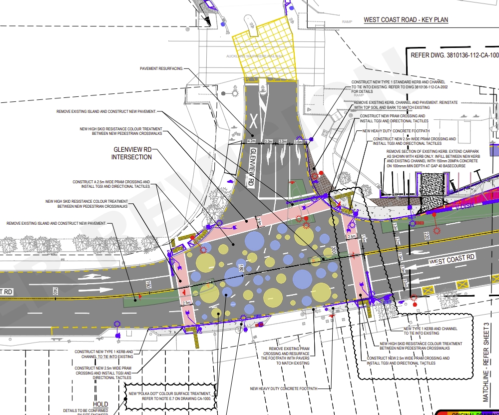
The West Coast Rd / Glenview Rd intersection. This was originally proposed as a raised table.
They say these changes will start in January and be complete by mid-2021.
National Cycle Network Map
Waka Kotahi NZTA have developed an interactive map showing all the cycling networks across New Zealand.
The interactive map consists of three parts: The New Zealand Cycle Trail’s 22 Great Rides which are mainly off-road, Heartland Rides which allow people to explore scenic back roads while enjoying stunning scenery and local hospitality, as well as council cycling infrastructure (cycle lanes, cycle paths, shared paths, etc).
It is the most comprehensive map available of cycling routes in New Zealand as it gives an overview to show how they all connect.
“The new map makes it easy for people to see how the network connects so they can choose a cycling route that will be the most enjoyable option to suit their needs,” says Robyn Elston, Waka Kotahi NZ Transport Agency Senior Manager, System Design.
Map users can click on a route to access a summary of the route in terms of trail type, grade, traffic volume and speed. This allows people to determine if a ride is right for them. The summary will also include a link to more information (where available) about the route on existing websites such as the New Zealand Cycle Trail.
One thing it does highlight is just how much is missing in Auckland.

It also seems the agency haven’t included the cycleway extension they completed last year between Lincoln Rd and Westgate.
Southern Motorway Widening
Waka Kotahi are holding some open days on their plans to widen the southern motorway between Papakura and Drury South.
People in south Auckland are getting a chance to find out more about improvements to the Southern Motorway ahead of construction beginning early next year.
In late November and early December, Waka Kotahi NZ Transport Agency will be at markets, sports grounds, service stations and shops sharing information on the SH1 Papakura to Drury South project.
It is part of the Government’s New Zealand Upgrade Programme, which is investing $6.8 billion in transport to save lives, get our cities moving and boost productivity in the country’s growth areas.
The Papakura to Drury South project will improve travel reliability and support growth and economic prosperity in the south.
It will improve transport choices with a new walking and cycling path, extra lanes with potential use for high occupancy vehicles and/or freight, wide road shoulders for future public transport and improved local road connections
There will also be improvements made at Papakura and Drury interchanges (the latter to allow for electrification of the adjacent rail line) and a new interchange built at Drury South.
A strong environmental focus for the project includes treating 100% of stormwater runoff from the highway and raising other bridges to address potential flooding issues.
….
In the meantime, the project is hosting four information days in the neighbouring communities for people to meet and talk with the Papakura to Drury South project team to learn more about these coming improvements to SH1.
- Saturday 28 November, 7am – 12pm, Pukekohe Farmer’s Market (7 Massey Avenue car park, Pukekohe)
- Saturday 28 November, 9am – 12pm, outside Drury Lotto & Superette (234 Great South Road, Drury)
- Sunday 29 November, 8am – 2pm, Pokeno Market (44 Great South Road, Pokeno)
- Saturday 5 December, 9am – 1pm, Bruce Pulman Park, Takanini (outside the Netball Centre, 90 Walters Road, Takanini).
More Rideshare services
The first privately run rideshare service linking commuters to ferries is being launched in east Auckland.
The unsubsidised MyMobigo service, run by Transdev, will use minibuses to connect people on demand, from nearby suburbs such as Howick, and Cockle Bay, with the ferry terminal at Half Moon Bay.
It is a similar concept to the publicly-funded AT Local service which Auckland Transport (AT) has been running at Devonport, on the North Shore, for two years.
Transdev’s entry into the rideshare market comes as Auckland Transport has taken first steps to set up a service in other suburbs.
In east Auckland, the MyMobigo service will from November 30, charge $4.50 for adults, and $3.50 for children and those on concessions, with booking and payment through a tailor-made mobile phone app.
AT are still deciding on what to do with Devonport but we can probably assume they want to cut the buses and continue it as they’re already talking about rolling it out in other places
AT has sought expressions of interest from technology providers, to possibly help run a similar service in Māngere and Papakura in the south, and Massey in the west.
A few final bits
Why wouldn’t we want this on Queen St too?
Incredible to be in Sydney's George St in the city centre – on what was the noisiest, most congested street – now a place for people.
All you can hear are the hushed sounds of people walking and conversing.
No traffic, no pollution pic.twitter.com/m7qm8ZX2Uu— Sara Stace (@sara_stace) November 26, 2020
Congratulations to MrCagney for their work on developing Access for Everyone that will transform the city centre.
A mighty congrats to @MRCagney on their award for showing @AklCouncil the way to wean Aucklanders off the 1950s drive-centric city centre model and embrace streetscapes for people with Access for Everyone #A4E https://t.co/B34RiptZU3
— Chris DARBY (@DarbyatCouncil) November 25, 2020
Everywhere red is more restrictive than the MHU zone (ie impossible or difficult to build 3 storeys). Everywhere dark gray is as, or more, permissive. pic.twitter.com/DjjH3aWtpt
— solarpunk! (@ScootFoundation) November 26, 2020
Have a good weekend.

 Processing...
In Devonport AT are consulting on parking changes, including charging for the Park and Ride (50c / hr) https://at.govt.nz/projects-roadworks/parking-changes-in-devonport-village/
Yep that’ll be next week with a raft of other consultations
I can’t wait to hear why, in a climate crisis, parking for Devonport will be free for a significant period.
Timmy, thanks for posting.
AT discussing their ride share service. https://youtu.be/JnX-D4kkPOQ
This last mile issue could be solved if they built the odd cycleway around the ferry terminals.
And train stations
Or made it more pleasant to walk.
Or had better feeder buses with all the ramifications that might have: priority lanes, better frequency and prices that were consistently more affordable.
And converted most of the parking to a really special Place to walk or cycle through in approaching the ferry terminal. And in the process, encouraging modeshift to active modes – which gets some cars off the road and supports the bus service. And in that important feedback loop that AT tends to ignore, this reduction in cars on the road improves the transport environment for active modes leading to further modeshift. The extra bus passengers should lead to improved frequency, leading to further modeshift…
Heidi
I like particularly your piece about the change in mode shift because clever city administrators know that it all starts there. If there are less cars there is less demand for roads, road resurfacing, car parks etc. And as a consequence more money for other things.
The feedback for the Glen Eden project showed, yet again, strong support for getting safe cycling infrastructure. Support was more than twice the opposition to the raised table, which they decided to remove.
And yet again, the excuse is that they can’t do it here, if they don’t do it there… We’ve heard AT say both that they can’t do it on the stretches until they put it in at the intersections, and they can’t put it in at the intersections until they put it in on the stretches. In this feedback, the words are:
“In order to implement cycle lanes, they would need to be considered in a more holistic manner rather than just being provided in small sections along the corridor…”
AT’s senior obstructors are using consultation as a way to remove the safety improvements they don’t like (improved pedestrian crossings, raised tables, safer speed limits etc) but not to insert safety features the public call for that they also don’t like (cycling infrastructure).
This isn’t about AT not listening to the public. The people doing the design listen, and try to accommodate what locals say into their designs while still following good practice. They simply have the senior obstructors overrule them time after time, so they eventually leave, disillusioned, or start proposing compromised designs in the hope they, at least, will get through.
Who is going to fix this?
I cycle the new roundabout on my commute and getting to the shops. Not looking forward to this new arrangement.
Sightlines are very problematic due to vertical profile, and the dual stoplines created by the zebras will only increase clashes between vehicles, pedestrians and cyclists. Going to be fun to interact with turning buses here.
It needed signallising, which would have made the intersection more compact, understandable on approach and accommodated provision for bikes – not blowing out into a larger footprint to facilitate flow.
Lots of the changes in this project are problematic, and for all modes.
There’s way too much red in that map by Scoot. Along arterials, and in places people really want to live, too.
We need both the government’s interest rate changes and Adrian Orr’s taxes, but we also need regulations changed to allow the perimeter block housing form to develop organically, site by site.
And we need a massive government programme of building high density along central TOD corridors. Not fast-tracking socially-incomplete distant car-based sprawl.
If there’s insufficient amenity (cycling safety, buses) to get to the Half Moon Bay ferry sustainably, then there’s insufficient amenity (cycling safety, buses) to get around those nearby suburbs. Providing rideshare is a stop gap to meet one particular need, leaving all the others high and dry, and possibly more out of sight than ever.
TransDev would do more good lobbying to get the massive car park turned into high density mixed use residential, and to get cycling and bus improvements in the area.
That neat story on Seven Sharp really is neat. How inspiring. Bridges are pretty interesting, eh?
I viewed that also and seven sharp did a great job but a shame with the waffle at either by their presenters . But the other major bridge works that are happening are on the NAL and none of the news media are saying anything about it . I got these from KR’s FB page and joined them together to show the work that is happening there ;-
https://www.youtube.com/watch?v=NqkWBcOZYdQ
Do we know when the line will be reopened. I heard a rumor its quite soon but I wonder if the Auckland upgrade and covid has slowed things.
It was suppose to be in December but with the lockdown’s I guess around Jan/Feb next year . I have also tried to find an answer to that so I’m just guessing , and 1 of the gangs seem to be working on the Auckland repairs also . We should get Matt L to find out for us ? .
According to Kiwirail it is early next year, not sure what early means though.
So I wonder what new customers they will get. I get the impression they will be targeting containers of dairy, meat, forestry and horticultural product to be exported through the Tauranga port. They know there is volume because they are handling containers of these products which have being trucked out of Northland every day at the Southdown Metroport site.
So wooden bridges and wooden sleepers is all being replaced with concrete which is not a co2 friendly material. Maybe a chance to develop some hardwood plantations for the next upgrade in 40 years. Maybe there is some railway land which could be utilised also pickup some carbon credits. I see Indian railway is getting into solar in a big way.
https://cleantechnica.com/2020/07/13/indian-railways-accelerates-toward-a-solar-future-with-new-tenders/
Still that’s the usual hype the reality is always different.
https://www.nzffa.org.nz/images/design/leaflet24a.jpg
Here is 90 year old Totara plantation. Need over 100 years to get useful timber out of most hardwoods. Its just not practical at the moment. Plus the significantly higher maintenance requirements which require c02 to be burned. Those sleepers are expected to last at least 50 years, perhaps significantly longer on a low traffic line like that. Modern concrete rail bridges should be essentially maintenance free for about 100 years. Hopefully they last significantly longer. Where does most of the c02 in concrete come from? the processing requirements or the reaction itself? Perhaps the supply chain could be optimized significantly to reduce the impact.
https://www.nzffa.org.nz/farm-forestry-model/resource-centre/information-leaflets/farm-forestry-association-leaflet-series/no-24-establishing-native/
Interesting article
The biggest producer of Co2 is I think the manufacture of the Cement . And KR brought in sleepers from Sth America which failed terribly and the installed a large number of them on the SOL line .
We also have used plastic sleepers here ;-
“In 2012, New Zealand ordered a trial batch of “EcoTrax” brand recycled composite ties from Axion for use on turnouts and bridges,[19][20] and a further 3-year order in 2015,[21] but then Axion filed for bankruptcy in December 2015,[22] though it continues to trade.[23] These ties are developed by Dr. Nosker at Rutgers University.[24]”
And this came from this wikipedia article ;-
https://en.wikipedia.org/wiki/Railroad_tie
I think plastic makes a lot of sense for this application. It’s much less likely to disappear into the environment than in other areas of use. Long lifespan. Other desirable properties for the railroad itself. If only these companies could stay in business haha
Not only the cement but steel for the reinforcing.
I am thinking they used Aussie hardwood for those bridges and possibly the sleepers. I often wondered if that means eucalyptus. Also creosote was used for wood protection which is not exactly envioroment ally friendly and probably cancer causing. Still so is cigarette smoke.
You are correct they used Aussie hardwood for the sleepers as well for the original power poles , and when they brought through the port in Taranaki they also imported Termites with them .
“And this article from Britain about creosote it basically has now been banned ;-
Legislation introduced in the UK in 2003, which prevented the use and re-use of creosoted sleepers other than for industrial and professional applications, prompted a feasibility study to determine if sleepers manufactured from recycled plastic waste are a viable alternative to creosoted softwood sleepers and, possibly, sleepers of other types.”
https://trid.trb.org/view/787107
Interesting article Jack. New Zealand hardwoods are mostly unsuited to structural uses and the cost will always put them out of reach for sleepers and bridges. Totara used to be used but it is a weak and brittle softwood and it didn’t really work out that well. It is the great choice for carvers and people building a waka but not much use for other things. But that didn’t stop colonials from cutting down as many as they could.
Kiwi Rail have done well. All for about $100 million.
Three new bikeways in Auckland are costing just about that much
And now if the £NZTA” had done it , it would be over budget and not finished for another three years . And then there excuses for the reason why .
No provision for future double tracking with those bridges I see
The section that needs to be Doubled tracked is through to Helensville , for the day when they may/will need it for commuter rail . As this LR still is a pipe dream .
Yeah I was disappointed to see that too. Easy option to do it once and do it right but instead they’ve gone the kiwi way and cheapened out.
Cycling infrastructure in Auckland is sure a piecemeal process,but we”ll never get anywhere,if “roading improvements” are made without provision for cyclists,if the Glen Eden roundabout is being rebuilt,make it bike friendly,getting the stretches done can be added later,would be great to get it all at once, but we know that won’t happen.I wonder if AT would feel embarrassed ,by just making the roundabout bike friendly,without any improvements on the approaches.But by doing nothing,it effectively means thats “it “for cyclists,it has taken years of consultation,to get to this far.lt’s very hard to remain positive, when,this stuff is constantly served up.l am a committed, commuting cyclist,who accepts my lot,but there’s no way l can encourage others to convert,l couldn’t in all consciousness, cope if any one l “encouraged “were to become a victim of Auckland’s abysmal cycling infrastructure
Does anyone in the advocacy world know of videos like this one: https://www.facebook.com/groups/interactfestivalonline/permalink/828940434565326/
but focused specifically on accessible active and public transport in Auckland? They’d be a really good teaching tool for presentations to the AT ELT, for example.
The video is presented there as part of the Interact Disability Festival, which is an amazing achievement, usually held out in Corban’s Estate but this year it’s online (and I know that some of the people who usually provide activities are doing much more outreach into the community also).
Great to see that dedicated busway bridge over the Tamaki river. But I’d be happier to see funding allocated for bridges like that alone the North-western motorway, over the Whau river inlet, etc.
WK-NZTA’s national cycle map:
The “most comprehensive map available”. Really?
The data quality is amazingly poor. Had a look at a few regions I knew reasonably well from a cycling POV: massively incomplete in some areas (several 10s of km missing) and even areas with reasonable coverage are out of date. Doesn’t give me any confidence about their data for regions I don’t know so well.
Also, describing long routes (10’s of km) as mixed on and off road and mixed surface isn’t particularly useful. Which bits are on road which bits are off road, what’s the surface, do any of the on road sections have cycle lanes, etc …
The Auckland Cycle “network” map – looks like a plate of spaghetti thrown against a wall, most of which has fallen off onto the floor. Details may be missing but generally an accurate impression, I’d say.
I wonder if this will give a kick up where it’s needed:
https://www.newsroom.co.nz/nz-may-be-excluded-from-climate-leaders-summit
Heidi, well spotted.
Here’s my favorite piece, “Last week, British High Commissioner to New Zealand Laura Clarke told a climate change conference that she was concerned about a credibility gap between New Zealand’s rhetoric and action.”
Almost right, but shouldn’t the last word be inaction?
I think we’ve been invited to the fast followers summit instead…
Two of these items feature young women in positions of responsibility. I just thought I’d mention that in case any angry throwbacks who like to moan about unrealistic overrepresentation felt a stone might have been left unturned here.
The dots proposed on the ground at Glen Eden don’t effectively slow traffic in that sort of environment. I feel this is inappropriate design element here, and am surprised it meets guidelines. Using dots in a location like this will mean they will become less effective in the low traffic environments where they are appropriate; drivers do learn to ignore cues like this if they become overused.
This comment is loosely connected to AT’s planning, or lack thereof, referred to above. A recent proposal has been to downgrade the bus lane on Esmonde Road to a T3. I was amazed to see, just a couple of months later, that a spur line is proposed for Takapuna. How can the two widely diverse propositions be reconciled? Either the public transport demand is there or it isn’t? Why would you remove a bus lane where, amongst other developments, a 400 unit development is imminent on that lane? The 82 bus also runs through most of the zone marked for apartment development?
Can the huge capital cost of a spur be justified when bus lanes on either side of the suburb i.e. Anzac and Esmonde, would probably achieve a better result because of the greater walk up catchment and greater frequency.
I wonder sometimes whether AT is seduced by the grandiose project when the cheaper option is best?
Having the busway spur to Takapuna would mean 82 users would visit a busway station north of the bridge which would be a huge advantage for Takapuna and the north shore network in general. The spur would take bus traffic from Smales farm too and wouldn’t be only taking previous Esmonde road busses. Akoranga station would become a bit of a bus hub, provided some other routes were considered and changed to go to Akoranga. Currently the most reliable way to get to takapuna from Birkenhead is to take a bus to Victoria park and then take the 82 to Takapuna. Which is crazy. Adding an Onewa road busway station would fix a lot of these issues however it seems like the future harbour crossing wouldn’t go here, and it would serve limited use as the catchment is tiny, its main purpose is as an interchange.
On the cycle map, the dominion road cycle routes look like they were drawn on by someone with Parkinsons.
All interesting thanks.