The Auckland Transport board meet again on Thursday and it’s been a while since I covered one of them, so I thought I’d get back to doing that again.
Closed Agenda
As always it’s the closed session where all the most interesting stuff occur and this meeting is no different.
One of the most interesting things on the agenda will be the Ministry of Transport giving a presentation on Light Rail. I assume this will be largely covering what’s happened so far and maybe some details on the ‘public sector delivery model’ they’re working on following the end of the previous process.
There are also three of the items for approval/decision by the board that stand out. The first and third of these they say will be soon be publicly available.
- Additional Waitemata Harbour Connections: Northern Busway Enhancements
- National Ticketing Solution (Project NEXT) and AIFS Extension
- Operational Greenhouse Gas Emissions Reduction Target
I suspect for the Northern Busway enhancements we could see things such as platform based tag posts or gates, like on the rail network, combined with all door boarding to speed up buses by reducing dwell times.
The Project NEXT update hints at that project being even further delayed.
For the emissions reduction target, it will be interesting to see how that compares to the councils Auckland Climate Plan which calls for reductions in vehicle kms travelled and big changes to the mode share mix in Auckland.
Business Report
The business report contains updates on things all over the organisation and the report itself has been streamlined a lot from what it used to be. The updates below are just a few of the items that I thought were interesting.
Parking
There are a couple of parking related projects that caught my eye.
- It appears AT are due to launch a ‘Downtown Valet Project’, possibly this week.
- The new multi-storey carpark in Takapuna, now called Toka Puia Carpark, is due to open in November.
- November will also see the introduction of licence plate recognition at their Ronwood Ave carpark.
What the Toka Puia Carpark is meant to look like when completed
Construction updates
This is just a few of the projects listed.
- Eastern Busway – this project seems to be going well and is now expected to be delivered in late June 2021, ahead of original date of October 2021. That’s impressive given the COVID disruption
- Puhinui Interchange – Construction is progressing but they say they’re looking for more access to the rail network that could ‘de-risk’ their programme. Given this would have been written a while ago, presumably that means they’ll be looking to capitalise on the current network shutdown south of Manukau.
- Lower Albert St Bus Interchange – The paving of the footpaths is in the final stages and due to be completed in early November
- Matakana Link Rd – work is on getting ready for the start of bulk earthworks. If it hasn’t already, presumably this will start over summer.
Transport Officers and Fare Evasion
AT have provided an update on transport officers, who they say haven’t been checking tickets during lockdown due to social distancing requirements. However, they also provide this graph highlighting the number of cases of fare evasion, which suggests it typically hovers around 1%.

Brownfields Programme Business Case
There’s a lot of energy going to encouraging sprawl supporting growth and we need an even greater effort to support the retrofitting of our city. While not on the same scale, this looks promising.
Following support from Kāinga Ora and Waka Kotahi, AT will shortly commence the development of a Business Case to assess the transport improvements needed to support the significant intensification planned for the areas of Māngere, Mt Roskill, Oranga, Northcote, and Tāmaki. The key outputs of the assessment will be the prioritisation of projects to enable and support growth, together with an assessment of funding responsibilities.
The areas are within the Brownfields of Auckland with the Kāinga Ora sites are a significant proportion of the growth in these areas through intensification and further urbanisation. In total these Kāinga Ora areas will accelerate the development and delivery of around 35,000 dwellings, with a focus on first decade delivery.
The business case is expected to take 4 months to complete and will examine the full spectrum of transport interventions including optimisation, PT, roading improvements, safety measures and active improvements.
Sprawl networks
AT also highlight how there are five significant private plan changes for greenfield development in Drury which are ‘out of sequence’ with the current development strategy. They also say
If these Plan Changes are approved by the Council, there will be an expectation that the necessary transport infrastructure will be provided by AT to align with development demands. However, there is currently no funding allocated for these areas and overall funding over the next decade is under pressure. AT is working with Council and government to identify potential funding and financing options, but it is not clear that will provide a timely solution.
This suggests there’s a risk that money for other projects, such as those which will support brownfields development, might not be available because of the need to support this sprawl.
Vehicle Occupancy Detection
AT have been replacing their manual bus and transit lane enforcement with CCTV cameras. So far this has just been on bus lanes but they say that from November they’ll start live trialling of technology that can detect the occupancy of a vehicle. They are targeting to go live with the technology on Onewa Rd in January 2021.
Speed Limit changes
Earlier this year AT implemented speed limit changes mainly in the city centre and on a lot of rural roads as part of their programme of improve road safety. They say that 27 roads were put on the wrong schedule in the bylaw. So they’ve reviewed them and decided for 26 of them they still need to change the speed limits. Yet despite saying there’s strong community support for the changes, they’re going through a full consultation process again on them.
The 26 roads are in Swanson, Massey, Warkworth, Matakana and on the Tawharanui Peninsula.
For the road that was dropped they say “was subsequently found to be located within the Urban Traffic Area boundary and so already has a safe and appropriate speed limit of 50km/h“. That statement doesn’t fit with the previous arguments and graphics (below) they’ve used to discuss speed limits, such as in the city centre.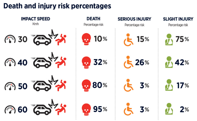
The changes that went live earlier this year were only meant to be the first of at least three tranches of changes. As such I expected this update to be substantial yet it seems underwhelming with only 26 rural roads. They also provide this ‘roadmap‘ showing what’s happened to date and what’s upcoming – which doesn’t seem all that much.

People highlights
AT have a short presentation on some of their ‘people highlights‘ which looks at a range of staff. Of all of them, this is the one that stands out to me the most. It’s good to see diversity improving but they’re really coming off a very low level and I wonder how different decisions would be if these were higher?

If you’ve read the papers, is there anything else that stands out to you?

 Processing...
Valet service you have got to be
Also in fare evasion – a LGOIMA response put the cost of a year of Transport officers at over $6 million. Fare evasion costs about $1 million. What’s the point?
Safety, security, reducing damage and vandalism. Identifying repeat trouble makers on trains and making it difficult for them to continue their “activities”. Serious PT systems all use transit officers or some other near copy, often with much greater powers than the toothless Auckland variety.
The question is what fate evasion would be if they didn’t spend $6m a year policing it.
At the moment I’d argue fate evasion doesn’t actually cost anything, the 1% who still do it aren’t going to be paying customers otherwise.
The problem is if you let it go completely and regular users stop paying (like the trams in Melbourne with 50% evasion), then you actually lose revenue.
For once, let’s stop with this fantasy that NZ is somehow completely different from the rest of the world and that solutions to issues used elsewhere, in this case ticketing, can be ignored because Kiwi is special. Roving transit officers, transit police, transport officers, whatever they’re called are absolutely necessary unless you want to go back to “all tickets please” like they do in Wellington.
What is your source for 50% fare evasion in Melbourne? I understand that 50% of passengers do not pay, but that is because most passengers are in the city centre where the trams are free anyway.
i believe the valet service is actually in conjunction with or just for Commercial Bay and is located on level 1 of the downtown car park
The valet service area has been under construction for a while. At the rear of the ground floor.
Fare evasion @1% ha ha, ha ha, ha ha, haaaaaa *facepalm* sounds like Trumps Covid plan… don’t measure numbers so they look better.
Drury… If a private developer wants to develop ahead of planned schedule and the infrastructure isn’t there for it then surely the council has a duty to decline permission to build it until the infrastructure is in place? (Unless the developer wants to pay for it of course!)
Watch this space, AKLDUDE. If a private developer wants to develop ahead of a planned schedule that itself doesn’t meet the international and national commitments we’ve made, and the Councillors propose saying no outright on the basis that the development would clearly increase emissions, what do you think the Council officers should advise?
“Back off because you’ll end up worse off” – on the basis that the developer might appeal and the nation’s processes are set up to support that developer and the status quo?
Or “we’ll support you saying no outright”, because if there is an appeal, it’s a good opportunity for the nation’s processes to be challenged and streamlined?
They chose to give the first advice. We seem to have Council officers who believe climate action can’t see the light of day, needs to happen in the shadows, at great cost in Council time and rates, with lengthy, costly hearing processes.
We need to become nimble, and if any Council should be up to this challenge, it should be Auckland Council, being the biggest. We need to nip the whole stupid palaver in the bud when we can.
“We need to become nimble, and if any Council should be up to this challenge, it should be Auckland Council, being the biggest.” Usually how nimble (agile) an organization is, is inversely proportional to how large it is. So Auckland council is the least likely to become more nimble.
However I would argue nimbleness means shortening / removing rounds of consulting and consenting from all the various sources which seems to be the biggest delay. This would mean essentially consolidating power in the upper levels of the council so fast and nimble decisions could be made. Consultations have been painstakingly added over the years and will probably continue to be so. Eg rounds of community consultation after motorway projects in the 70s or whenever had 0 and destroyed them. Mana Whenua consultation after whenever that was added. Rounds of Engineering consultation because whatever is designed needs to fulfil actual physical requirements. GA and Bike Auckland heavily rely on these consultations to change the status quo so I don’t know that it would be wise to remove any of this. Unless you stage a coup or get voted in with enough like minded people then the council becoming more nimble seems like a bad idea to further your goals. And thats not even touching on the fact that usually its a bad idea to consolidate power in any various governmental structure.
Auckland council is postively dynamic compared with the much smaller Wellington councils. Then there’s the ongoing project NEXT snafu, also a product of these “more nimble” smaller councils…
Yes, lots of good points there.
Auckland Council, being the largest, should be up to the political and legal battle required to remove barriers. Once that’s done, I’m sure you’re right, that the smaller councils will still be the most nimble. But given its size and therefore lower ability to be nimble, Auckland Council has the most to win by speeding processes up.
We need to approach this with deliberative democracy. Set the goals, and work back from there, removing barriers to progress as they appear.
There is a whole body of knowledge about how our consultation processes are skewed to support the status quo. So although Bike Auckland and other advocates try to work within the system as it is, and manage some influence via the existing process, it isn’t set up for their needs in the slightest.
The situation has become quite a farce, and the longer we follow systems that don’t meet our needs and let them slow us down, the tougher the transitions will be, and the worse the outcomes.
RE: Drury – Duty, possibly. Legal right to decline, unlikely.
Councils can’t decline development just because the development is senseless or harmful.
Toka Puia is a lovely name for the Takapuna carpark. Rather than Volcanic Rock I would have called it Contaminated Land. Would that be paru whenua maybe?
But how contaminated is it? They built a New World on the old gasometer site in Freemans bay, can’t be that bad.
It isn’t going to be as bad as the Beaumont St site as they didn’t make gas in Takapuna, I think it was only ever stored there. But the list of potentials for a coal gas storage area is: “Free tars & oils, PAHs, BTEX, phenolics”. PAHs are aromatic hydrocarbons usually at the surface and BTEX are the benzenes etc that contaminate water and deeper in the ground. https://www.mfe.govt.nz/sites/default/files/gas-guide-aug97-final.pdf
In other words similar to the compounds spewing out of the exhaust. If it is covered in concrete and people do not spend a lot of time living/working in the car parks then exposure should be negligible. It is only hazardous if the exposure pathway are complete and you get exposed to a high enough dose.
Does adding new carparks in a building mean that carparks can be freely removed from surrounding streets? Since those people can now park in the building.
No, because that would mean walking another two blocks in one of the flatest suburbs in Akl.
Heck, if you want to start a riot put on some high-vis, stand in the Anzac St carpark and talk loudly on your phone about removing the car parks – You’ll be mobbed before you could say “oh my pearls!”
The plan is to have unlimited coupon parking in surrounding streets for $5 a day. This car park was unlikely to be commercially successful, but now they have ensured that this will be so – after the obligatory consultation of course.
Isn’t Skypath being built on contaminated land? Funny how NZTA managed to bury that story.
Perhaps there should be an audit of all the contaminated land in Auckland and the organisations responsible can be held accountable.
Perhaps land contamination should be considered as a cost of vehicle emissions.
Buried in the Monthly Indicators Report:
• On trajectory to meet target
• In August 2020 0.6 km of cycle facilities were completed (Murphys Road)
• The 2019/20 target is to complete 5 km of new cycleways.
So the annual target is now just 5km, slashed from an already deeply unambitious 10km. How’s that mode shift and climate action and Vision Zero going, AT?
Meanwhile, the official cycle counts (which only capture a fraction of the active travel movements across the city) are back to normal levels, and bike shops are predicting a shortage of stock before Christmas. Public uptake and demand are off the hook. But the safe infrastructure goal has been halved.
How’s AT’s new “Easy Journeys” mission statement feeling, folks on bikes?
Perhaps we could come up with some official looking specific proposals like what was done with GA’s regional rail proposal but for cycleways. My personal vote is Manakau Road between Newmarket and Cornwall park. Newmarket is a major employment center, the park is a great distributor and would provide lots of last km access without having to modify heaps of local roads. The route is pretty flat, and the road has a large median through most of it that could be eaten up for a bi-directional cycleway. This road is my current blocker to commuting from Onehunga to UOA by bike.
+1 but I would run it down to Onehunga/Mangere Bridge.
There a number of other improvements on the Isthmus. It has some wonderful trails, but it is actually hard to get to places of work. Manukau Rd would be an excellent start.
Great suggestion, Jack! Funnily enough, an “official-looking specific proposal” already exists — the Auckland Cycle Network, as created by council and enshrined in the Auckland Plan.
In theory, this network should underpin and feed into all city transport planning, from Local Board greenway plans, to what should happen on major arterials like Manukau Road (although the latter work has recently been absorbed into the Connected Communities programme, which should – in theory – be delivering some spectacularly transformative plans for PT and active transport on key arterials, any day now…)
You can see the ACN map here, on Bike Auckland’s website:
https://www.bikeauckland.org.nz/wp-content/uploads/2015/11/2015-11-Auckland-Cycle-Network-A1-combined.pdf
Oddly, though, you won’t easily find it amongst AT’s public-facing communication. E.g. the GIS maps would be a logical place to look, but only show existing cycling facilities (painted lanes, etc):
https://data-atgis.opendata.arcgis.com/datasets/75bbb3afce054ee9a2826fd89c18e4bf_0?geometry=174.627%2C-36.920%2C174.860%2C-36.872
And AT’s top page of Transport Plans and Strategies doesn’t refer to any cycle network plans or strategy… https://at.govt.nz/about-us/transport-plans-strategies/
… not even in the “coming soon” section! Which is weird, given AT’s Cycling Programme Business Case was presented to and warmly accepted by AT’s Board in 2017. Luckily, you can find that document in the minutes of that 2017 meeting: https://at.govt.nz/media/1974191/item114-auckland-cycling-programme-for-investmentfinal.pdf
It’s a strong, detailed, well-researched ten-year programme, with the stated goal of “deliver[ing] on the Auckland Plan target of building 70 per cent of the Auckland Cycle Network by 2030.” More relevant, more urgent – and more strengthened by central government policy – than ever.
It would be good to know the current board is all over the details of the Cycling Programme Business Case, whether it’s progressing (and if not, why not), and why it isn’t front and centre in AT’s strategic storytelling.
(Apparently there’s also a fabulously readable version for public consumption, which has been sitting in final draft form for the last few years, gathering dust. Such a waste of good work – and a missed opportunity for positive public engagement to build rapid consensus around climate action and health!)
This is very concerning. It appears work is done and then buried.
If this were an actual plan you would have seen at least a few of these materialise purely due to regular road maintenance. (For example parts of Glenfield Road got resurfaced recently)
That is not the case.
On Glenfield Road it is also notable that the “completed” part doesn’t actually exist, the shoulder lanes have bike stencils painted on them but they are too narrow to be usable as bike lanes.
Roeland, I can also say that some of the local routes which are “existing” are totally unsuitable. I can speak to the two shown along the waterfront in Clendon and Conifer Grove – each are very narrow footpaths, heavily used by the elderly and dog walkers. The Clendon path even has stairs!
Yeah, I’ve read all of the ACN stuff I could find, but there has been not a peep about the vast majority of the network, and especially any that are near where I live. I was thinking a more concrete proposal for an actual route, that seems easyish, proposed directly by the community might have more of a chance of getting some sort of action. AT haven’t really been putting any more routes out for proposal. Rather they have slowly been funding and completing sections that were consulted and mostly designed years ago. (aside from the obvious skypath and some little sections here and there). That section of Manakau road and Broadway through Newmarket need some bus priority improvements too.
Wheely, great news though. Takapuna is about to have 0.2km of new bike lane, currently being constructed on Hurstmere Road. Compare this with the $30m currently being spent on the construction of the car park. Only one of course will provide an acceptable climate outcome. What is particularly sad is that this (the car park) was signed off at the highest level with the mayor having his hands all over this.
It will be fascinating to hear how AT plans to tackle climate change. I imagine top of list will be raising some roads; there will be lots of talk about EVs that until 2030 will be powered by Huntly coal and gas; and anything else? Little evidence of it so far.
On the “Operational Greenhouse Gas Emissions Reduction Target”
“For the emissions reduction target, it will be interesting to see how that compares to the councils Auckland Climate Plan which calls for reductions in vehicle kms travelled and big changes to the mode share mix in Auckland.”
As I wrote in “The Forty Decision-Makers,” the Lawyers for Climate Action outlined to the AT Board in June the legal obligations the organisation has in relation to climate. This is from a slide of a presentation they made to the AT Board in late July.
https://www.greaterauckland.org.nz/wp-content/uploads/2020/08/Does-the-SOI-meet-ATs-legal-obligations.png
So, yes.
Will AT set this target to be in line with their legal obligations?
Will they set it to meet the lower obligations set by the Auckland Climate Plan, ie to achieve a 64% drop in transport emissions by 2030? – which at least would require some hard decisions to be made.
Or does the word “operational” hide a whole lot of “switching to LED light bulb” ideas?
And how will the Board respond?
Heidi
I am interested in your thoughts on – “to achieve a 64% drop in transport emissions by 2030.”
I thought I saw that 55% of this would come from uptake of EVs. Have you seen any figures to support this? The current trajectory and what is happening in the market such as a slow reduction in price and limited uptake in Japan make this seem unlikely. And fueling them with Huntly power that covers demand shortages. And then the Productivity Commission talked of more lines infrastructure if there was widespread uptake.
The whole plan just seems to be “big picture” theoretical stuff with little practical chance of working.
Have you heard whether Auckland has reached peak emissions yet in terms of out C40 committment?
“I suspect for the Northern Busway enhancements we could see things such as platform based tag posts or gates, …”
I guess gates wouldn’t be that easy or nice as it would limit the flexibility of the buses to park a bit out of position and/or have such restrictive walking/entry areas. If you always had to pass through the buildings it would be so much easier but you may want to go from one bus to another without needing to go into the building. You may also want to wait in the building but not exit to the last second when a bus arrives due to the weather etc etc.
Little interesting thing on the very last page of the Business Report:
Passenger Information Displays (PIDs)
The real-time team are rolling out changes for the Rail LED PIDs that shows live occupancy information. Most of the rail network still have these older style PIDs on platforms. This creative solution (using percentages rather than icons) allows us to show occupancy information consistent with other channels such as AT Mobile, AT Web, and LCD PIDs.
It’s a year old but I missed the October 2019 safe speeds “decision” with its splendid wiggle room: if a road’s not “high risk”, presumably in comparison with other Auckland roads (laughable), AT will back down on a safe speed rollout if the locals whinge hard enough. So business as usual, then.