Here’s our roundup for the week
Eastern Closed for another two weeks
Yesterday Kiwirail announced that they were keeping the Eastern Line closed for another two weeks to continue replacing tracks.
The Eastern Line was due to re-open on Monday after a two-week temporary closure but will now re-open on 21 September.
Recent testing revealed that about 100km of rail in the Auckland network needs repairing or replacing. A speed restriction of 40km/h is in place across Auckland and it is anticipated this will be progressively lifted as the repair work is carried out.
“This project involves considerable logistical complexity to ensure staff, contractors, machinery, rails, sleepers and ballast are all in the right place at the right time to enable the work to progress,” KiwiRail Chief Operating Officer Todd Moyle says.
“We have made a good start on the Eastern Line with 1000 sleepers replaced and close to 6km of new rail laid so far.
“We’re bringing in teams from across the North Island to help get this job done as quickly as possible.”
The replacement of rail tracks is done in two stages, involving several steps. After the old, damaged rail is removed, new rail is cut to size and lifted onto the sleepers where it is connected by welding each piece together. Once installed, it needs to be stretched and rewelded to ensure it is the right length to cope with hot and cold temperatures – a process called de-stressing.
This once again begs the question, what on earth have they been doing during all the network shutdowns over the last 15 or so years.

The Eastern Line between Quay Park and Westfield is about 15km so that’s 30km of track and means so far Kiwirail have replaced about 20% of it. At a rough guess, if they stay at about that level they should have replaced about half of all the track by the time this extended shutdown is completed. Unfortunately there’s no word if this extra two weeks means all the works needed are completed and speeds on the Eastern Line can return to normal or it’ll still be six months before that happens.
Building Consents
Despite the impact of COVID and the risk of recession, one positive so far is that building consents are holding up well. Data released for July shows there have been just under 14,9k consents issued in the 12-months to the end of July which is not far off the peak in December of over 15.1k.
What’s also positive is that recent trends are continuing with the big difference being medium and higher density typologies making up the bulk of consents with standalone houses accounting for just 44% of them over the year.

Of all consents, council figures to the end of June show about 28% are within 1500m of an existing rapid transit station.

It will be interesting to see how this changes once the new National Policy Statement on Urban Development comes into effect. Though one worrying sign is that the council are already shaping up to try and water it down by only using very small walking distances and other tools. This feels like the council planners are already cowering to the opponents of change and while one part of council uses 1500m for the figures above, another part of council are trying to use a completely different figure.
Webinar yesterday on the NPS-UD included J.Duguid from Akl Council.
We are gonna have Unitary Plan 2.0 fight on our hands.
expect
-400m walking catchments
-Dominion Rd maybe not upzoned bc of reverse sensitivity with Eden park
-Volcanic view shafts used to not upzone
-etc— Matt Prasad (@matty_prasad) September 2, 2020
Back to building consents, another positive sign is we’re still seeing new schemes being announced. For example last week was this interesting and positive development planned for the former church site on Esmonde Rd and will have 231 apartments. The site is right on the 82 frequent route with a very quick trip to town thanks to the bus lanes on Esmonde Rd and the motorway. It is also not too far from the Akoranga Busway station. Soon it will also be not far the Northern Path which will include Skypath and there are also already local board plans for a pedestrian/cycle bridge from the site over to Francis St to enable other connections down the Devonport Peninsula. I also understand the developers plan to limit parking but make use of car share scheme.


Density and diversity
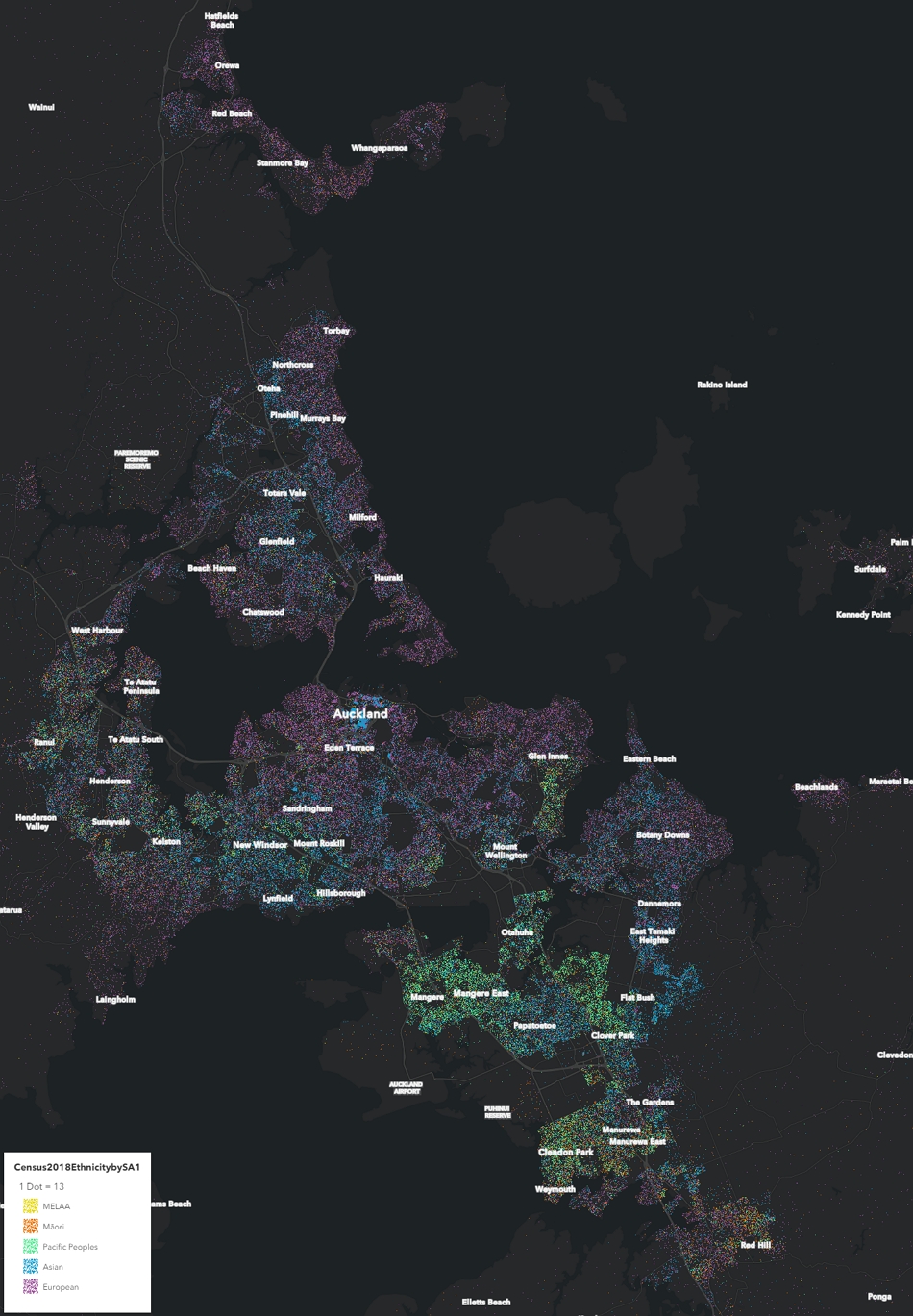
Stats NZ has released some neat maps combining density and ethnic diversity.
Stats NZ has developed a series of interactive maps, focusing on two aspects of 2018 Census data – population density and ethnic diversity.
These maps can help answer questions about the population density of New Zealand’s suburbs, towns and cities, as well as the ethnic diversity within these places. They help us see where ethnic populations are living closer together, forming their own communities (lower ethnic diversity), and where many different ethnic groups are living together, to create higher ethnic diversity.
We have presented the data at the statistical area 1 (SA1) level, using publicly available, confidentialised data. SA1 is the smallest geographic area that population data from the 2018 Census data is available for publicly.
Below is Auckland’s urban area highlighting that while Auckland is diverse, especially compared to the rest of the country, there are some very distinct pockets of ethnicity throughout the region. Click through to here for an interactive version.
Another funding shortfall
With fewer people travelling, Stuff reports there’s also less fuel tax coming in to pay for the projects it was designed to cover.
Auckland has lost out on about $15 million for transport projects due to a sharp drop in fuel consumption during the first coronavirus lockdown.
The four-month drop in consumption began in March during the first lockdown. The figures do not yet include the hit from the nearly three weeks Auckland spent in alert level 3 during August.
Shorter stuff
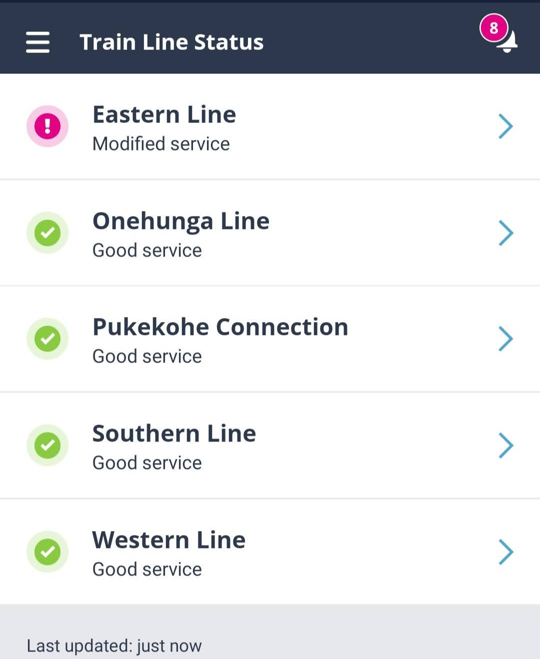
AT have added a new feature to their mobile app showing the status of train lines. This is useful but with trains at reduced speed and frequency, I don’t think they can really claim that it’s ‘good service’
Register your HOP cards
New feature rolled out overnight – if your AT HOP card is unregistered it will beep three times.
Make sure your card is registered – It’s great for contact tracing, plus you can sync it up to your AT Mobile app for custom notifications! https://t.co/bvnEYfRR71@AklTransport pic.twitter.com/FLidNgUjvm
— John (@johnage) September 1, 2020
I came across this interesting tender from Auckland Transport showing they looking at removing all pedestrian level crossings from the rail network. By my count, not including those where there is also a road crossing, there are 14 crossings and nine of them are at train stations.
This Request for Proposal (RFP) is an invitation to suitably qualified participants to submit a proposal for preparation of the Pedestrian Level Crossing Removals – Single Stage Business Case.
The outcome is to deliver an approved SSBC that identifies preferred options for the removal of each of the pedestrian level crossings in question, either by closure or grade separation, and demonstrates the appropriateness of the preferred interventions through the NZTA business case process. In conjunction with the business case, concept designs and a design report are to be provided foreach site.
The outcome is certainly one I’ll be keeping eye on as I need to use to to access my local station but I also ride through it if I’m riding to work or town.
Progress on the Victoria St cycle lanes – though they do look a bit narrow in places
https://twitter.com/johnage/status/1300611295083786241
Progress on the Tamaki Dr improvements with the new cycleway becoming clearly visible
Tāmaki Ride Cycleway pic.twitter.com/kEHrPQotZk
— Timmy (@gallicist) August 30, 2020

 Processing...
NZTA have also formally announced the Alliance team for building the Northern Pathway (nee Skypath) https://www.nzta.govt.nz/media-releases/waka-kotahi-signs-up-alliance-partners-for-northern-pathway/
Surely the entire 30 km of the Eastern line won’t need replacing. Before this current fiasco, they claimed to have replaced km’s of the track on the Eastern line and it would be finished by July. They also need to front up as to exactly what the cause of this system wide failure is. Doesn’t seem to happen in Australia on much busier systems.
Seriously there needs to be some transparency. I don’t necessarily need heads to roll. But just so a complete maintenance failure like this one never happens again. From what I could gather, they might not have been grinding rails enough, and this caused the fatigue.
+1
Crap quality rail steel. That’s what it is. Some of the tracks are <5 years old.
If your only moving one, two or three stations down the line the 40 kph speed restriction doesn’t make any difference. But it turns the network into a bit of a tramway. I was thinking well if its a tramway might as well reopen Wuri, Mangere, Westfield and Southdown which would certainly add some walk up passengers. With a third main and possibly a fourth coming maybe we could look again at these stations and run a stopping service in peak hours maybe only from Penrose to Wuri but probably Newmarket to Papakura. Industrial area buses have failed maybe time to have a look back to how things were done in the past.
If these stations can be easily put back in service (and that’s a big if) then the big barrier to their use will be walk up catchment. Auckland’s industrial areas are extremely hostile to pedestrians, worse even than the suburbs. Narrow, discontinuous and poor condition footpaths, where they exist at all. Lots of heavily trafficked driveways. Wide, heavily trafficked roads with very few formal crossing opportunities.
As you mention the bus network doesn’t deliver great service in these areas. Routes are often infrequent, meandering and poorly connected. However even if they were better then the hostile walking environment would still be working against greater bus patronage.
Southdown & Mangere would have to be built from scratch. Both were demolished and tracks realigned (in the case of Mangere also adding a third track). Neither cheap nor easy to reverse.
Anyway sceptical of the concept of making an already slow service even slower …
1. It’s Wiri (not Wuri) – it’s got nothing that can’t be managed by Manukau literally a kilometre away – the Manukau South Link would be highly beneficial here
2. Mangere – why? It’s a few hundred metres from Middlemore, Ōtāhuhu is not far in the other direction and there’s literally nothing there. Anyone going there is going to need a bus anyway so the hub just down the street is fine. Plus there’s no infrastructure there at all.
3. Westfield – there’s nothing there that isn’t better served by Ōtāhuhu.
4. Southdown – there’s literally nothing here. You’d need to build a LOT to even get passengers close to anything in the area.
We could certainly do with the odd infill station – Tironui, Mt Smart, Drury, Paerata.
Additionally AT have made it abundantly clear they only care for 9-5 workers. Industrial areas are almost always shift workers who will have no use for a train that doesn’t cover 2/3rds of their shifts.
All negative then well just putting it out there.
Key Points
1 Buses in industrial areas have failed.
2 Extra tracks gives an opportunity for extra stations.
3 Simple stations with short platforms only need to cater for three car trains.
5 Most trains will bypass these stations only some southern trains will stop at these station.
6 We need another pedestrian crossing of the rail between Westfield and Penrose a reinstated Southdown would provide this.
7 Provision of stations would incentivise improvement in walking infer structure.
Trains have stopped at all these stations in the past and very few passengers used them, why would it be any different this time?
The church on Esmonde Road seems like an oddly isolated spot to build apartments. And OK you can catch the bus to the city but that is the only thing within easy walking distance.
There’s all that retail and light commercial area on Barry’s Point Rd though. Including being <1km walk from the nearest supermarket.
850 metres to Countdown. Is that too far? Is it possible to walk that area?
Yes the distance by itself is not that bad, but it is just not an inviting environment to walk. I would expect that anyone who can will drive a car.
First you have to cross Esmonde Road. Maybe that crossing will be done properly, maybe it will stay between those 2 turning lanes. You can assume it is a 3 minute wait right there. We have a bad track record with these things.
Then, Barry’s Point Road is your typical light industrial / commercial area road. The kind of street where it is obvious that you’re not really supposed to walk there.
You’d walk to New World at Hauraki Corner surely? Right on 1km and you can use the back route through residential streets or along Esmonde and Lake Road with no road crossings.
Yes that would make more sense.
Nice to see the former AOG site being used for something worthwhile, it was always a waste as a church.
There’s also a really really good pie shop on Barry’s Point Rd.
But how would you go to that pie shop though? I’ve been to the bicycle shops over there before, and it is a scary proposition even in a car. You’re basically on a motorway on-ramp there.
If we’re going to have apartments there, ideally we would also think long and hard about how to arrange Barrys Point Road. Well: we have had apartments in the city centre for decades now, and much of it (especially the western half) is even today still a parking and huge roadways crater. So I wouldn’t hold my breath.
Now by itself this is not a super bad place for apartments, however there are so many better places to put apartments right now. Starting with the town centres. Most are essentially uninhabited (they are strictly commercial only, often in single storey buildings).
As someone who lives just around the road this could be an outstanding site for apartments.
Connectivity will be the key.
I have long argued that the 82 should run only from Milford to Akoranga. First this offers the ability for people to go either south or north from Akoranga. Second it allows those going north to go to either lower Queen or mid city. Third by connecting at Akoranga it provides greater frequency on the bus way than the 82 offers. Fourth by ending the 82 at Akoranga it cuts two thirds of the distance from the journey. These cost savings would allow the 82 to be run at much greater frequency. An 82 with turn up and go frequency, day and night, would make trips to the town centre, gyms, bars, cafes and Milford compelling to do by bus. It would certainly connect this significant development in many direction. This is the sort of connectivity that makes cities like Vienna so liveable.
There’s a walkway/
Cycle waythough the Patuone reserve behind Barry’s Point rd, it starts behind the bike shop following the shore line around the inlet with a path up to Countdown , Auburn reserve, and finishing at the bottom of Northcroft st right into central Takapuna. The traffic lights at the Barry’s Point rd Esmonde rd intersection just need a beg button fitted and some paint for a crossing, problem solved
According to Google it’s a 15 minute walk to the Lake Rd/Hurstmere Rd intersection. 1.2km.
A boardwalk from Francis St across to this new development would be great for walking/cycling connections in this area, particularly people going to the bus station or Barrys Pt Rd
Similar to the fairly recent boardwalk to the south which connects the Bayswater and Belmont peninsulas
Ah I can see this connection is already identified as ‘G9’ in the local greenways priorities list
If you look close at that first render, you can actually see that G9 link in there by the looks
I think the view would be a big draw card. If your a bike or bus (or car?) “person” I guess it would be quite good. Anyone know what car parking provision it will have?
The problems that people have talked about with walking are overstated. This site is on our route when we walk around the block. Walking on the northern side of Esmonde feels unsafe. The traffic often moves at at least 60kph and feels very close to the often narrow footpath. The south side is much more pleasant because it is next to the busway which has only ocassional buses. AT is intent on destroying this busway and turning it into a T2.
Barrys Point is not as unpleasant as it has been painted. I regularly walk this street after alighting from the bus at Akoranga. The nature of it is changing as the light engineering is replaced by cafes, bike shops, motor bike shops, outlet retail, and professional services amongst other things. The footpaths are reasonable and are separated from traffic flow by parked cars in many places.
Undoubtedly the major hazard on this street is Countdown. At one time the exit from the car park had a stop sign. This was sensible as the exit passes over the footpath. Now it has a give way sign and most drivers interpret this as meaning to other cars.
Really pissed off on the eastern line farce. I will just keep working from home!
It is a bad joke. Plus they have the audacity to publicise it only a few days before it was meant to reopen. There’s no way Kiwirail only found out yesterday that they needed to spend 2 more weeks on it.
400m walkable catchment seems a copout. Having said that, the NPS-UD is a blunt, flawed thing
If they’re putting the stake in the ground at 400m, they’ll need to be consistent. If the planners don’t have a KPI on what %age of Aucklanders are within a walkable distance of RT, and of FT, etc. then they will soon, because it’s a useful tool. And at 400m they’re going to look pretty incompetent.
I think 400m is disingenuous. 800m is comfortably walkable, most of the time, for many people.
Having said that I think there is good reason to concentrate density with 400m. It’s just the walkable catchment reason isn’t a good one.
Bikeable reaches kilometres taking less time than it does to walk a few hundred metres. So by rolling out more bike infrastructure along with the rapid network we could simply upzone the whole city and drop this argument.
I like 400m in terms of concentrating focus around redevelopment and infrastructure upgrades. There’s a big danger in my view of going for indiscriminate density.
Having said that the NPS UD directive is about walkable catchments, and they are usually bigger than 400. My walk to my train station is 600m, I do it in a moderate paced walk in 8 minutes.
Transit/TranzUrban are doing a pilot electric conversion of two of their BCI diesel double deckers. Looks like they’ll operate in Wellington at this stage. If successful, could be more conversions across their BCI manufactured double & single deck fleets in Wellington and Auckland.
Media release (on Scoop): http://wellington.scoop.co.nz/?p=130721
That census map is a depressing display of how Auckland (the only really diverse of NZ’s major cities) has an effective system of socio-economic apartheid going on – with the exception of West Auckland outside the Titirangi “crunchy’ enclave.
No doubt barriers to entering the housing market do play a role but there must be some effects at play that aren’t inherently negative. Auckland is a city of immigrants. When moving to Auckland you choose where to live based on where you can afford to live but you also take into account other factors; where family and friends already live and where amenities are that cater to your needs (specialist supermarkets, churches etc.). So agglomeration effects tend to draw in people with similar interests.
All over the world immigrants tend to gravitate toward areas that their confreres live. Even NZers – in days past Bondi and Earls Court were where we chose to live in Sydney and London.
Kiwis haven’t chosen to live in Earls Court since the 70’s. Kiwis, Aussies and South Africans used to congregate at the Overseas Visitors Club, that was by accounts a wild place, my dad has enough stories from there to write a book. When I was in London in the late 90’s Earls Court was being gentrified and was way to expensive.
I am not impressed with MELAA. Middle Eastern, Latin American and African is not an ethnicity. It is a ‘we gave up trying and bundled some different groups and invented an abbreviation”.
Echoes of the”BAME” nomenclature they use in the UK.
Neither is pacfic peoples or asian. Its a grouping of ethnicities which would otherwise be rounded out to 0 and not included in such analysis if kept individual.
and they missed off Antarctician.
Totally agree though, Latin American isn’t an ethnic group either.
MELAA is short for miscellaneous.
The map is not too far removed from a “visible minorities / minorité visible” map (see Canada). They just need to split the Asian “ethnicity” into ‘South’ and ‘East’.
Middle Eastern, Latin American and African. http://archive.stats.govt.nz/Census/2013-census/profile-and-summary-reports/ethnic-profiles.aspx?request_value=24776&tabname=Aboutthedata#gsc.tab=0
Speaking broadly of ethnic labels, I was told the other day (by an Indian colleague) that Maori and all Polynesians could not be called brown, brown is reserved for people from the Middle East and the Indian subcontinent. First time I’ve ever heard that.
‘ socio-economic apartheid’.
Haha. That’s hilarious.
In other news, i recieved an email today, with a positive high energy subject
“Central Crosstown Bus Services Consultation – We listened, here’s what’s happening”
It then goes on to say that after taking 8 months to consider the consulation repsonses, , what is going to happen is…. wait for it… your’re going to be excited!… we are going to do… absolutely nothing!
What happens next?
They are going to wait another 8 months and then start from scratch again
taking time to “explore other options ” then ” in early 2021 we will present them to the community ”
Wow, go AT, yup really living up to your core values
Auahatanga
Better, bolder, together
That’s so disappointing. It was, finally, a really good resolution to the inner link’s massive problems. Who on earth is defending the status quo on that route? What possible journeys are people making that would be worse off with a bus every 15 minutes instead of three buses in 15 minutes follwed by a half hour wait?
Yes got this email too. The only thing I would give them is them analysing the new 64 route usage as it develops.
They look at the “39% of you told us that you didn’t want to take more than one bus to complete your journey” I guess as big weighting I would think but of course you would always get that on any route where it’s working for the people currently using it. If so, this is nuts to put too higher weighting on, as a bigger group of people that don’t currently use a potentially better service have probably not given feedback.
Yes.
The bus people at AT should go and talk to the bus people at AT. They rolled out this thing called the “New Network” where they figured out people would take the bus if the routes were frequent even if it meant a change.
Yes, what was the point of the consultation if they are just going to say, ‘let’s keep waiting and watching’? So disappointed. Such a missed opportunity to turn the 650 into a frequent 65, to complement the new 64. GRRRR! Phil Goff must sack the AT board.
Why pay an expensive board to make decisions when all they do is just send out a questionnaire and action the majority result without rational analysis?
The NPS UD stuff is particularly frustrating. I can sort of understand the 400 m so long as the whole council is consistent. However, not upzoning due to viewshafts is trash. The viewshaft is a constraint, it is still constrain if you zone to allow 6 stories, just how the viewshafts still apply in the city centre zone! Not upzoning Dom Road due to Eden Park is also trash. If the reverse sensitivity is that bad, then we should be mandating triple glazing, noise gib and 200mm noise insulation on all new buildings because, surprise, occupants of standalone homes are also subject to the effects of noise!
The general approach the matt Prasad is describing is a massive bugbear I have with planning in general. If you have a specific planning concern (viewshafts, noise, shading, stormwater), then they shuld be addressed by specific planning rules, not by just preventing all development in the area!
Yeh don’t know what they’re doing there. Did they go and explain to the people sitting in their cars that improvements are targeted at them, so they can get places by bus?
Looks like they treated it as a vote – of the people already using the bus. Why would those people want to change things to make it work for more people when it works for them now? Nuts.
Sorry. reply to Dan C.
It’s even worse than that as many people who currently take the bus supported the changes.
Yes that consultation report shows nearly half liked that the “Buses will be more reliable, frequent, efficient”.
I like 400m in terms of concentrating focus around redevelopment and infrastructure upgrades. There’s a big danger in my view of going for indiscriminate density.
Having said that the NPS UD directive is about walkable catchments, and they are usually bigger than 400. My walk to my train station is 600m, I do it in a moderate paced walk in 8 minutes.
Difference between 400 m and 1500 m planning is between attractive and possible. Using 1500 m as a sole standard would favour development at the furthest distance from PT, where land would be cheaper, rather than within 400 m where PT use would be more likely. Attractiveness of the walk is more critical than just the distance. 600 m uphill is not so attractive as 800 m on the flat along a pleasant route without crossing delays. Planning rules to incentivize the best possible results is always going to be difficult and needs to be supported by good design rather than be indiscriminate.
But land wouldn’t be *much* cheaper, and relatively meaningless when we are talking about high density development where construction costs are much more significant than land costs.
I would agree generally, so long as the maximum were about 1000 m and therefore land costs might be closer. But it is also availability as well as cost. Cost cottagers close to stations won’t sell. People with homes (occupying or letting) on the fringes are more likely to capitalize on the price margin of the planning gain. Compare standard freehold plots in new suburbs nearest destinations that are most marketable with fringe areas that cost more to develop but have lower value – so the developer goes for Kiwibuild to get certain and quick returns, leaving dense “affordable” homes in least accessible places. What we should all agree is that incentives need to promote best and avoid unintended poor, including building transport poverty.
Typo, meant to write “Cosy cottagers “
As I have said before, these things will not be successful unless the govt gets much more involved in apartment development. Few people seem to understand this.
“What’s also positive is that recent trends are continuing with the big difference being medium and higher density typologies making up the bulk of consents with standalone houses accounting for just 44% of them over the year.”
I wonder though whether in practice this statistic has any value. While I imagine almost every standalone consent proceeds, in our area I imagine only about half the consented apartments end up being built.
Good point. And tellingly, apartments are still a low proportion.
‘I imagine’… not really saying anything unless you can substantiate that.
I am sure it’s based on some real world experience, if not data. From the work I do in and around the development sector, it’s definitely what I see. Quite a few apartment developments don’t proceed.
Here’s some of the apartments that have not proceeded in Takapuna
3 on the southern side of Anzac including the Paragon
1 on the other side
1 on Auburn
the Loxley
Summer Gardens
I completely agree with you that we should advance evidenced based arguments.
Maybe I have imagined the other side of the equation wrongly, but here’s my thinking: if a spec builder applies for a consent he is likely to proceed, and if an individual is granted a consent the same seems likely.
As much as I think Auckland needs way more apartments than stand alone housing I don’t believe consents show the true story.