Last week we had yet another port report and another new preferred location. This is the second port study in just eight months and the third in four years, although report this is more inline with the report from four years ago. It also goes to further strengthen the suggestion that the last study, a requirement of the NZ First coalition agreement, started with Northport as the preferred outcome and worked back from there. Here’s the press release.
The Government has released a major new report on the options for relocating the Port of Auckland’s freight operations while deferring any decision on the issue.
“That decision needs to be informed by policy analysis that is still to be completed. As a result it will be up to a future government to determine a preferred location,” say Transport Minister Phil Twyford and Associate Transport Minister Shane Jones.
Phil Twyford says this issue has significant fiscal, economic, social and environmental implications. “Because officials have been focused on COVID-19 response and recovery work they have not yet been able to provide advice on Sapere’s assessment of the benefits, costs, risks and uncertainties associated with the options.”
The new report by economic consultancy Sapere was commissioned by officials to inform that policy work. It considers five relocation options: Northport, Manukau, the Firth of Thames, the Port of Tauranga and a shared increase in capacity at both Northport and the Port of Tauranga.
Its key findings include:
- The port’s current downtown Auckland location has about 30 years’ capacity and there is a 10-15 year window for making a final decision on relocation
- For all five options, engineering and consenting could be difficult
- Manukau Harbour was the highest ranked option, although consenting could be problematic
- The economic costs would outweigh the economic benefits for all the options, including Manukau.
For this new study they say they’ve looking at options to provide capacity for a 60-year period, out to 2079. That makes sense as it’s going to take at least 10-20 years to make a decision, get consents and then build something.
Base Case
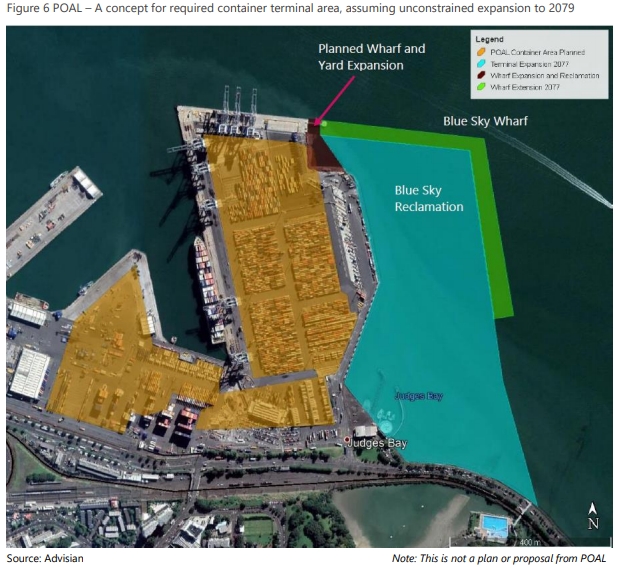
To start with they’ve looked at the base case for accommodating the predicted growth in the freight task at the existing port site. They say this image is not necessarily what would happen but gives an indication of the scale of reclamation that would be needed to accommodate it.
The potential options.
Northport
As with previous suggestions, this would see a major expansion of Northport. However, this report says:
Northport could provide sufficient berth capacity until around 2060, which is not materially longer than the estimated 30-year capacity at POAL. To accommodate the freight task for the minimum test of 60 years, marine and coastal engineers conclude that Northport would need a 2km long quay, involving dredging and reclamation that expands beyond identified constraints to the west (residents, wetlands) and to the east (into Refining NZ’s liquids berths and well beyond) with significant impacts on coastal processes affecting the nearby coastline and channel.
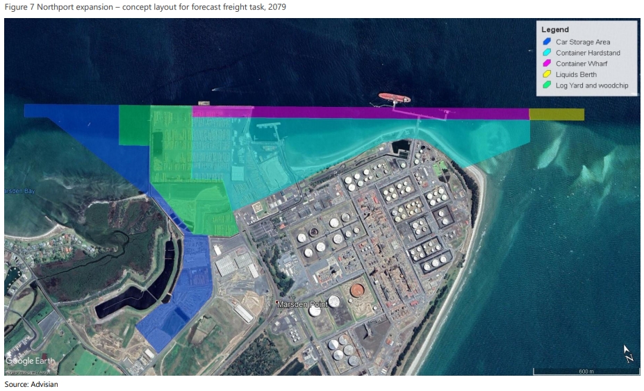
They also note there would be a need to bring forward plans to extend the motorway from Warkworth to Marsden Point which includes the $2 billion Warkworth to Te Hana section and a complete bypass of the Brynderwyns. It also requires a third track on the western line all the way from Swanson to Avondale, which given the corridor is already constrained, is likely to be very expensive.
Tauranga
Tauranga has issues too.
The Port of Tauranga would need significant expansion, into industrial areas on each side of the estuary channel, to accommodate its own long-term freight task and that of POAL. The necessary addition of berths and container facilities to the south and east would impact on flight paths and the airport runway, bridge marina and highway would need to be relocated. Marine and coastal engineers advise that tidal currents mean the increased shipping activity would be challenging, with a risk of congestion affecting vessel operations and limiting port capacity. Even if this long-term capacity can be realised, Tauranga would have few remaining options, other than expanding to the west of Sulphur Point, into the public reserve and marina

It’s not mentioned but this would appear to also require a new Harbour Bridge. They do say it would need improvements to SH1/SH29 between Cambridge and Tauranga, additional passing loops on the East Coast Main Trunk (the Kaimai tunnel would not be a constraint), improvements (presumably double tracking) at Whangamarino as well as a fourth main from Westfield to Pukekohe. Though to be fair, some of that is needed now anyway to also support metro and intercity services too and we should be building the fourth main at the same time as the third goes in.
There is a suggestion of slightly smaller expansions at both Northport and Port of Tauranga with the freight task shared between them. There is a concern that in 60 years both ports are likely to be full and then have limited expansion options. There is also a “significant risk market forces would direct freight such that capacity at one or other port may be constrained by the limits described above at an earlier date”.
Firth of Thames
The Firth of Thames was one of the favourites in the 2016 study and if chosen would see a new port built likely offshore and linked back to land by a bridge. The focus of the image is on Kawakawa Bay as it is representative of the costs that would be incurred but the actual location could be elsewhere.
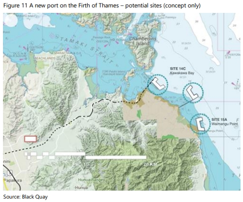
For transport they say
A new road connection would be needed, likely a four-lane road from the Mill Road area with a bypass of Clevedon, with an improved connection from Mill Road to the Southern Motorway. A new rail line, connecting from the North Island Main Trunk, would traverse some complex topography near Kawakawa Bay that would require some high-cost tunnelling.
Manukau Harbour
The Manukau Harbour option is favoured because it’s the closest to the existing industrial areas where most of the freight would be going, therefore resulting in lower overall transport costs. As the map below shows, there are three potential sites that would all need to be connected back to the land via a bridge. They say the Puhinui site is the focus for their study as it is likely to have lower construction costs due to being closer to land.
Of course the biggest thing people bring up about Manukau is getting in the harbour in the first place. They say that in the view of port planners, dredging is feasible and access wouldn’t be a problem with modern ships and tugboats if necessary.
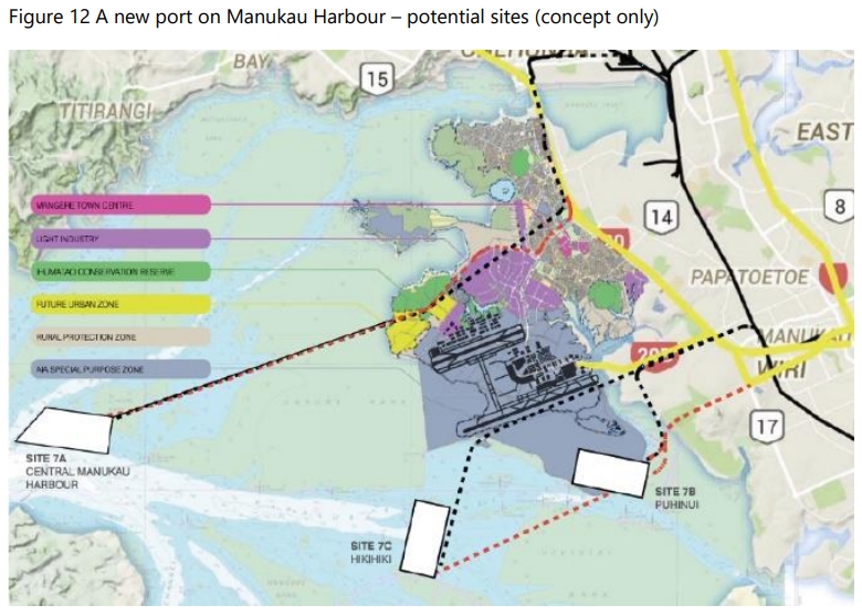
For access it would need a new arterial road which would effectively extend Wiri Station Rd westwards and some motorway interchange upgrades. It would also need a connection to the rail network – though I imagine this would more likely be along a similar alignment to the road than what is shown above.
Costs and benefits
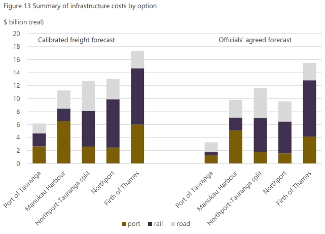
The costs of each option vary quite a bit and are shown below. The difference between the two is due to different growth assumptions with government officials assuming a lower rate of growth and therefore a lower level of new capacity is needed.
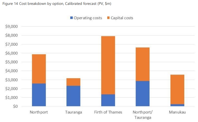
But the picture changes once operational costs get considered and this is where the Manukau site really shines.
As mentioned in the press release, none of these stack up economically though. Manuaku does the best here returning 44 cents for every dollar spent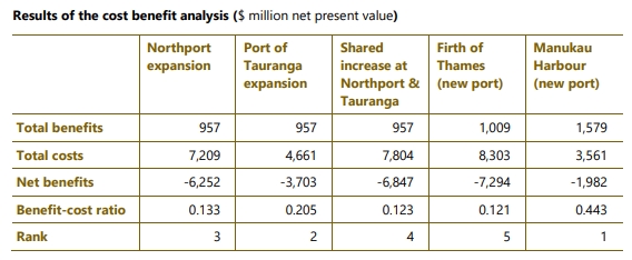 Other Stuff
A few other interesting takes from the report.
Our technical professions continue to let us down when it comes to transport modelling. The report includes a section on the city centre transport impacts from shifting the port. It considers higher and lower intensity redevelopment options and says that either option will result in slower traffic speeds through the city.
The results of these forecast flows associated with the POAL site have been assessed in the Auckland City Centre SATURN model. This model has a furthest horizon year of 2036, so this year has been used for the assessment. The ATAP assumption, that the grade separation of intersections along Grafton Gully (at The Strand and Alten Road) would occur has been included in the model.
Table 22 below summarises the average travel speeds in the Auckland City Centre under two redevelopment scenarios for the year 2036. By this year the general increase in CBD traffic will reduce average travel speeds between 18 to 27 per cent. In the event the site is redeveloped, increased congestion will further reduce CBD travel speeds. The key finding is that average travel speeds in the Auckland City Centre are likely to be lower under the higher intensity redevelopment scenario by 7 to 12 per cent than what would otherwise occur in 2036 under the base case.
The above speeds relate to the averages within the entire model, so the results may under-represent the extent of congestion in particular areas. However, the model outputs indicate the extent to which the higher intensity redevelopment scenario will lead to lower vehicle speeds in the city centre

This kind of modelling, where it appears they’ve just extrapolated existing conditions, really lets us down. It clearly hasn’t taken existing trends into account, such as that over the last 20 or so years, traffic to the city in the AM peak has actually reduced slightly and the significant growth in jobs, education and entertainment have been accommodated primarily through the increased use of public transport. There’s no reason to assume a new development on port land wouldn’t be the same – and given issues such as climate change, the area would need to be designed to have low access by car and a focus on PT as well as walking and cycling.
Where speed is needed though is for our traffic engineering professions to hurry and and get with the programme. Getting cars through the city as fast as possible is not the aim of the city and the council have been talking about ideas like Access for Everyone which focuses on people, not pushing cars though the city. And if traffic speeds are much lower, perhaps then people won’t drive and will change how they travel.
Finally, there’s this interesting table looking at why the outcomes of this study are different to the last one.


 Processing...
There is a real danger of back and forth debates on this issue with little being done a lot like the debate over another Harbour Bridge/Tunnel. A lot of studies being done and continuous debate. I don’t like the idea of an option being chosen and working backwards. Also Northport and Tauranga are a looong way away from Auckland.
I think two or three things are needed: 1) an iron cast commitment the port will move in the next 10 to 15 years
2) A royal commission to get all the evidence together on best options and come to a conclusion about where the port will go
3) Special legislation if needed to allow consenting
By the way what did this report say about building anything in Muriwai? Has the Kaipara or Mahurangi Harbours been considered as options with new ports near Helensville or Warkworth?
Previous report looked at Murawai. Huge relaimation required. This and Kaipara would need the same ongoing dredging problem as Manukau.
Mahurangi would need initial dredging and reclaimation.
All require road & rail links, and are on the wrong (north) side of Auckland and its southern freight hubs.
For an east and west coast option I think the report rightly identifies Manukau and firth of Thames as the best contenders, assuming additional expansion at POAL is not allowed. It also identifies a 10-15 year window for a decision. Given the covid recession/depression, I wouldn’t expect much action for a decade.
Back and forth is what happens to ‘bright ideas’ that are actually terrible. The third harbour crossing is a classic example, a hugely expensive and disruptive boondoggle that’s would make traffic worse. The real problem is that pollies and armchair experts won’t admit its a terrible idea, so they keep rehashing a study every couple of years to find the best ‘option’. But like moving the port, all options are worse than doing nothing.
Agree.
Keeping the port where it is, is quite probably the best option.
People, often with vested interest, are trying to desperately find a credible argument to the contrary….
Back and forth is the whole point. The purpose of this report is to stall the whole process so that Northland doesn’t get to steal our port.
The last thing we need is people claiming “Something Must Be Done!” Because let’s face it there isn’t actually any problem. The port we have works fine, there is another port at Tauranga that works fine and if they were to face any actual capacity issues, which they haven’t, there is a third port at Marsden Point.
Yes, I thought it was just me who was asking the big “why” question. Sure, the port is not in a great location, and as a walker I’d love to be able to access the shoreline. But to build a new one and get 44c (max) in the dollar back for your trouble: have we gone crazy? Are we actively trying to build a high-cost society (‘cos it’s you and me who will be paying the bill)?
I can think of any number of other projects where we could get a heady 80c in the dollar back. Why not waste our money just a little less wastefully?
It’s election year, folks. Let’s try to get the best bang for buck that we can in this Covid-constrained time. For once I think that to “do nothing” may be the right thing.
With some of the NZ Refining partners wanting to close down Marsden Point , one of the most vocal being Z, if that happens moving the port north is almost a forgone conclusion, they need the jobs.
Well the why is because there’s a 30 year window before capacity is reached and it’s going to take almost that long to get consents and build, so decisions need to be made soon.
With a BCR of 0.133 it would probably be better to pay all the redundant refinery workers their full salary for the rest of their lives.
A 30 year window? That has to be the lamest justification I have ever seen. In 30 years we might have a problem so vast sums must be spent now? In case we have a problem?
I think what will happen is that the van will continue to be kicked down the road. They’ll simply have increases at both Northport and PoT to take the load away while keeping PoA going at current levels (maybe a bit of an increase). That should mean about 40 years to decide and by then it should be a lot clearer what is needed, where and the economic costs will be more justified.
Agree, the study shows all options will be effectively throwing money down the drain. Hard to justify for the sake of opening up more of the waterfront for housing and cafes, especially at a time of real uncertainty for the CBD.
Sounds like someone will get a sore foot.
It’s not (just) about opening up CBD waterfront land; capacity will be reached in 30 years which means we will them need a new port to take over.
Assuming status quo pre-covid economic trajectory?
Why does that mean you need a whole new port and the closure of the existing? If there are problems in 30 years the market will ensure some freight shifts to other ports like Tauranga or Northport. It is almost like an invisible hand guiding us or so a Scotsman once said.
There is another option – a ship canal from the Tamaki estuary to a new port in the Manakau.
https://www.scoop.co.nz/stories/HL1912/S00091/keith-rankin-another-option-for-aucklands-port.htm
https://timespanner.blogspot.com/2008/11/canal-that-was-never-dug.html
I don’t know how practical this is, but it has got to be at least as easy as dredging the wild, shifting sands of the Manakau heads. There is a reason all our harbours on the East coast.
The largest cargo ship to currently visit NZ is the Maersk Antares – https://www.nzherald.co.nz/business/news/article.cfm?c_id=3&objectid=11722093.
This ship is 347m long, has a beam of 43m and draws 22m fully loaded. A ship canal would have to therefore be at least 50m wide and 24m deep, and the Tamak estuary dredged channel would have to allow these ships as well.
Anyone know why this isn’t more discussed as an option?
Probably because it’s an even bigger and more ridiculously expensive plan with no extra benefit?
If creating a shipping channel through the tamaki river to get to the canal was viable, why wouldn’t you just build the port on the Tamaki and skip the canal?
Locks, a second harbour bridge-style crossing for road and an even longer one for rail. Huge disruption during the build.
As the first study points out, sand movement at the heads is from south to north. Having established the initial channel, further dredging would consist of continuing to move sand from the south to the north.
‘There is a reason all our harbours on the East coast.’
This must be a bit of a revelation to Port Taranaki.
Port Taranaki is actually a bit of a QED. It is built on a north facing coast (considerably shelter from the West and South provided by natural features) and it still has to be an entirely artificial harbour of extremely limited capacity. It is a toy port, no real competition to the huge natural and safe harbours on the east coast.
The cost of bridges as high as the existing harbour bridge for the motorway and the railway line alone are probably the main reason.
Because nobody can predict how big ships will be in the future. The harbour bridge was built steep with a big hole underneath to allow ships to get to a future port at Pollen Island by the NW motorway. But that port can’t be built because ships that are now used for container freight are too big to fit under the harbour bridge.
…and if you calculate the clearance required by today’s container ships (let alone an allowance for future increases), add an allowance for the bridge structure and then calculate how long the approaches to the rail bridge would be at, say, a maximum 1% gradient it becomes apparent that there are kilometers of structure required at each end (refer Hughey P Long bridge, New Orleans) rendering a number of stations and Westfield yard obsolete.
Not feasible.
The ship mentioned above Aotea Mærsk isn’t even close to the largest in service today, she’s a 10,000 TEU vessel, the largest are 400m long and approaching 22,000 TEU. This is currently looked at the maximum practical size, there’s only 20 ports currently equipped to support ships this size, none of them are in Australasia or even America. I think you can safely say we won’t get anything this size visiting NZ anytime soon.
Ships can only be a certain size. The giant ULCC tankers would never use a port like Auckland, and as pointed out few ports can accept them anyway. The Maersk Antares is by the largest vessel we could ever expect to regularly visit NZ – in fact, a ship canal wouldn’t have to cater to this size really since Tauranga could be designated for this size. I only mentioned it as illustrative of the sort of engineering work required. The best argument against a canal seems to be from commentators MFD & jezza, who point out the considerable engineering work required for roads, bridges etc either side of the canal. The rest of you are just being smart alecs.
Of course there is an advantage – if Auckland was to put a canal right through the Auckland Isthmus, then it would no longer be on “the North Island”, but would have instead created two new part islands – North of the north and South of the north.
Then Auckland could declare themselves a sovereign nation and not have to put up with all those politicians from Wellington that Aucklanders seem to hate so much (despite that most of them are from Auckland anyhow..).
Free at last, free at last! Free from the tyranny of the South….
All these port studies seem to start with two assumptions that I think are wrong, or at least would be foolish to take for granted.
1) The assumption that POAL is a monolith that can only be moved from one location to another, not a disparate set of functions (container import/export, car import, bulk goods import etc.). The different port functions accommodate completely different ships so could be relocated, or not, completely separately.
2) The assumption that in decades to come our mix of export and import goods will stay the same. Will Northport and Tauranga still be exporting bulk unprocessed pine logs? Will NZ continue to own a lot of cars per household and import a lot of cheap used Japanese cars? Will NZ be importing bulk hydrocarbon fuels at all?
If you start with the wrong assumptions and/or questions of course you’ll get the wrong answers.
These ‘port studies’ are a joke. They have clearly been written to support the position of the instructing party. Your comments are bang on.
In the end I think common sense will prevail, the Auckland Port will remain where it is and an expansion to allow for future growth will be made elsewhere, mostly likely at Northport. As ugly as it is, Auckland Port is a key piece of economic infrustructure for the region and moving it elsewhere has massive implications on our carbon footprint.
To me, moving the port out of auckland makes about as much sense as moving the airport out of auckland.
The manukau is maybe an option, but at what cost?
Yes and they wrongly assume:
3/ Competition between three ports must be avoided at all costs. For some unknown reason they assume that a port must remain a monopoly making each port a mutually exclusive option.
Yes, I agree Logarithmic Bear and miffy. I’d add they wrongly assume:
4/ Our future economy will be based on the movement of ever increasing volumes of stuff.
None of the lower carbon, more sustainable economic paradigm shifts that we will need – more circular economy, more value-added industry for exports, less reliance on imported vehicles and fossil fuels – require an increase in port activity.
Except we are closing down our manufacturing industry in NZ, we will continue to increase our reliance on imported products, we don’t make most of the thing’s we use in NZ and if you do find a kiwi made alternative it will (usually) be more expensive than an imported product.
A good example is outdoor clothing, Earth Sea Sky locally produced, high quality, very expensive vs MacPac formally made in NZ now lower priced, reduced quality and made in China.
Yes. In particular there’s no mention of the likely closure of Marsden Point oil refinery.
don’t forget Glenbrook steel. The govt’s done a great job, NZ’s three largest industrial sites gone on their watch. Once they are gone they are gone, we won’t get them back.
The causes are nothing to do with NZ’s government.
– An oil refinery only servicing the NZ market can never achieve the economies of scale that refineries in much larger markets can. This has been the cause of refinery closures in Aus also.
– Steel and aluminium are the subject of heavy trade protectionism in many markets (incl. China and the USA) which distorts the market in ways that make NZ smelters noncompetitive.
– Trade protectionism aside, NZ smelters also can’t achieve sort of scale that overseas producers in larger markets can.
– The Covid-19-induced worldwide recession will decrease demand for steel, aluminium and refined fuel for who knows how many years.
The NZ government could subsidise these industries to stay open but to what end? It’d only be deferring the inevitable.
The money not spent on subsidies could be better spent helping those who lose their jobs retrain and change career paths. Or by enabling the creation of industries that have a future in NZ.
Apart from Glenbrook where are the others located? In towns where they are the largest employers, where the local economies will take a massive hit, which will take decades to recover from if ever. I have no issues with the govt subsidising all three plants.
@jezza the govt did end our oil and gas industry, no more exploration, so might might as well kill off the only refinery we have. It currently refines over 70% of the fuel we use, including fuel for aviation.
Imported fuel will probably end up being more expensive than our existing mix of domestic and imported, I would expect to see price increases across the board as a result of this.
Torsten – almost all the crude oil used at Marsden Point is imported, most of our oil produced in Taranaki is exported to refineries in Australia. It’s not the same type of crude oil.
The government’s ban on exploration has little effect on Marsden Point or security of supply.
From a national security point of view, closing our only oil refinery would be a disaster.
How? If there is a risk our supply of refined fuel could be cut off there is equally a chance our supply of oil could be cut off. A refinery isn’t much use without oil.
Yes, though they have the Northport/Tauranga split option.
If we’re going to be stupid enough to move our port hundreds of kms from our biggest city and in the wrong direction from our biggest population/commerce centres, then let’s go the whole hog and move the port to Taupo.
Lol, comment of the year so far.
+1
GREAT place for a deepwater port. Why didn’t I think of that?
Also a good location for a space to land port? 🙂
I put a video together that shows Northport would be a better option as there is plenty of space still available and what gets me is were there ever any reports done in the 1800’s saying why they where built were they are now ? ;-
https://www.youtube.com/watch?v=iHtTjIrzseM
And connect it via a canalised Waitkato river! Sorta like the Manchester ship canal, only biggerer! 😉
Lets just leave things how it is. Build the rail link from Oakleigh to Northport and let competition and environmental politics work out what happens next. My guess is we will see most of the manufacturing and distribution facilities gradually relocate along the rail line between Waharoa, Morrinsville through to Hamilton and then to South Auckland. Already you can see two inland ports being built in the Waikato and a large number of business locating there. South Auckland industry won’t go away but growth will be in the Waikato. Similarly the land around Northport will be home for many new business’s. Ports of Auckland will shrink or remain static.We just need to make sure sufficient capital is put into the railway so it can meet the challenge so we are not overwhelmed with a fleet of heavy road traffic juggernauts. Of course housing will follow the jobs so we can expect some sprawl. But there maybe some ex industrial sites in Auckland which can be repurposed for housing. The main thing is a relentless drive for increased rail traffic both freight and passengers. Pokeno is probably the next site for a inland port or maybe one could be built at the site of the old Meremere power station.
And reopen Morrinsville station it should never have being allowed to close. I suppose you can blame the National govt for that or was it lazy Kiwirail management who just found it to hard to handle freight and want somebody else to do it for them.
I always feel like there are a few glaring omissions in these reports.
Firstly, they always put the Firth of Thames Access through Kawakawa instead of Miranda. The Miranda route is closer to existing infrastructure and relatively flat.
Secondly, they seem to miss a lot of other benefits. There is no consideration of the agglomeration benefits of redeveloping the port to urban land uses, no consideration of the health benefits of moving ships out of the city centre.
That traffic model is also disappointing. There’s a reason they have used average speeds, not jouney times. Most journeys into the city centre are only about 800m from the noose at most. I.e. all of that terrible congestion adds less than a minute (and in most cases, much less).
Miranda? You’ve gotta be kidding. Would never fly. Ever.
Based on? (Genuine question.)
I’d also like to know why not. This report recommended a shipping channel dredged through the Manukau Bar, but a motorway through the foothills at Miranda is out of the question?
Surely the political costs of “industrialising” the Miranda coastline would be enormous. I can see huge opposition because “Miranda” is associated with a pristine (relatively) environment with unique wildlife. It’s also very susceptible to weather events (IIRC the northern-most part of the coastal road has been under serious repair on several occasions in the last decade because of slips etc). I don’t think it would be politically feasible, irrespective of the actual harm it may or may not cause. Tunelling, maybe, but I still come back to my original question: why do anything at all? Just let market forces play their part. (Never thought I would ever write those words . . . )
You wouldn’t be industrialising the Miranda coastline, you’d be running a motorwy and railway in the foothills. The industrialisation would still happen up the coast.
To be clear, I don’t think that this is a good idea. I think that if we move the port to the locations within the Firth that all of the port studies have identified, then the best land access is through the Miranda area, not the Clevedon Valley.
If you mess with the Bar-tailed Godwits Then I will be lying in front of a bulldozer.
Yep, can’t imagine relocating a massive port to a place known as ‘the seabird coast’ is going to sail past environmental groups without a peep.
I just noticed Sailor Boy’s suggestion of Miranda. This is a very sensitive migrating bird sanctuary area. The last thing this area needs is a bloody great port and all that that brings. Another thing that is lacking in this debate is a shift of some of Auckland’s economy to Northland. There is a lot of flat land around Marsden Point. That area could be developed for more of the industries planned for Auckland. Auckland is bursting at its seams currently. We have a housing and water crisis. Why do we need to be so greedy and keep putting everything in Auckland when there is an option in Northland, where there is large unemployment. Also omitted from this discussion is the potential to utilise the old Whangarei Port for some small ship operations. I also don’t see too much of a problem with the 2km wharf at Marsden. It looks pretty straightforward to me. Just because it goes over current consents does not mean it will not be consentable per se, especially when one looks at the environmental impacts of both the Manukau and Firth of Thames. Another advantage of NorthPort is a new rail deviation south from Marsden Pt. Crossing the Waipu flats, the line could reconnect with the North Auckland Line at Mareretu. This would eliminate three large grades on the current route an enable a standard locomotive to increase its train weight from about 630 tonnes to about 2000 tonnes. These developments would be better for New Zealand. A little less Auckland- centric, but I believe, still better for Auckland in the long run.
I’m not suggesting a port at Miranda, please re-read my comments.
Putting a port anywhere near Miranda is a nutty idea. Every environmentalist protest group in the country would turn the place into a warzone.
“none of these stack up economically though”: Surely all that sea frontage land in the CBD is worth a fair bit, both in terms of sale price and in terms of the increased economic activity that could occur there. Only $1.5 billion in benefits from moving to Manukau seems very low to me.
If all that land is only worth $1.5 billion to the economy over 60 years, then the whole Auckland CBD can’t be worth that much either. Something is wrong in their calculations…
The only thing is I would say is that it will only have a lot of value if you develop it commercially, and if you want to do that you have to do it over a long period of time. The $1.5b will be a discounted value, whereas the total value spread out over twenty or thirty years will be a lot higher than that.
But who would benefit from the land, my guess is the majority would be handed over to iwi which would benefit them and nobody else.
Knowing Twyford: He’s done this yet another study for purely political reasons, trying to salvage Auckland votes after the light rail was put to sleep.
I have to be extremely sceptical of this report’s credibility. If Manukau harbour was ever an option for a major port then that’s where one would’ve been developed in the late 19th century, instead of the low capacity, coastal shipping port that exists. And it wasn’t because Manukau harbour, along with most of NZ’s West Coast, has major issues with build-up of sedimentation. Such a port would require ongoing dredging of sedimentation, and every time there’s a major storm, the port would need to be closed until the extra sedimentation is dredged. Not only would this be an ongoing cost but it would completely ruin the local ecosystem. I’ve seen how the port at Newcastle NSW works where they have major sedimentation issues, not as bad as Manukau harbour’s issues, but it’s persisted with because (unlike with Manukau) there is no other option.
Auckland’s waterfront port needs replacing. And Tauranga’s already suffering from the traffic it gets. Marsden point (with the rail upgrade) was always the best option. And I would never trust anything Phil Twyford gets involved with.
Agree. He’s a phoney.
It’s a sham report commissioned for electioning purposes. It’s already understood that:
1) The harbour entrance is too dangerous for large ships and shippers won’t use it as insurance won’t cover them.
2) The constantly-moving sandbar at the entrance will require 24/7 dredging.
3) The silt-laden harbour channel, some 20km in length, will need to be dredged every year and since it will take a year this means it too will be continuous dredging.
4) It’s further to go for most shipping lines.
Every cent of the $2m should be returned to taxpayers.
Hear hear.
I can understand why Aucklanders want to keep a major port in their region. But why on earth some are so hell-bent on an option that would cause so much disruption and environmental damage is incomprehensible to me.
Their goal is to keep the port where it is by making Northport look like a bad option.
Nobody seriously wants the port in the Manukau or Firth of Thames, the two groups are those who want a move north and those who want it to stay put.
If it’s saved us billions by not moving the port to Marsden then it’s been money well spent. Wayne Brown’s group could refund us though for basically creating a report that gave Shane Jones the answers he wanted.
The sad part is that all they really needed to do was build the railway to Northport, then the market would have done the rest, each shipper using whichever of the three ports suited them best. The railway could/should have been built on Northland forestry rather than tying it to the port move. Even without anything at all shifting from Auckland (though cars likely would have), the railway would be well used, at least assuming KiwiRail made log wagons available.
It was an opportunity lost, as NZ First is likely gone after the election and the port move talk will vanish. At least the NAL got an upgrade, but it’ll unlikely see any new freight on it. Winston has blindly believed that infrastructure investment leads to tonnage growth, when in fact it’s KiwiRail’s freight policy that determines that, and that hasn’t changed since 2010, and actually has its roots from the Beard era in 2000.
Geoff – agree regarding completing the connection to Northport and allowing it to compete. Winston has lost the chance to leave a bit of a legacy, instead his main achievement in government has been to stop things happening, which probably won’t last.
Yes also agree on “The railway could/should have been built on Northland forestry rather than tying it to the port move.”
The conclusions that stand out are that the existing report has plenty of capacity and there aren’t major benefits of moving. We can move the port if we want to pay the economic cost of doing so, but there is no need to rush into making the decision when the existing port has capacity and there are no great alternatives.
Manukau is the logical option. It’s right there next door to the largest freight and industrial areas in the Auckland region and probably the whole north island.
Future technology in shipping and dredging can make it happen.
Northport, Firth of Thames and Tauranga are just lunacy.
Future technology in dredging doesn’t solve the actual problem, the bar changes daily, dredging isn’t cheap, any port there would require round the clock dredging, no amount of future technology is going to solve that problem or stop the tides or any storms.
Good discussion.
For me this report looks like a big step in the right direction.
A few points:
1. The report moves the discussion from a 30 year time frame to a 60 year time frame. The existing port has been in place for 150 years without our predecessors having to deal with relocation. Maybe planners should do future generations a favour & at least give passing consideration to a 100 year time frame, despite the challenges of predicting even further ahead.
2. The report concludes that the Manukau Bar can theoretically be engineered for safe access for ships of any size – it’s been done elsewhere. However, I agree with all the comments here about the currents, shifting sands & likely ongoing channel maintenance costs. Delays – 30 days a year seems to be the average for waves of over 4 metres at the entrance. The report on the grounding of the vessel “Spirit of Resolution” (a mere 100m long) is worth a read.
3. Auckland city seems to be expanding southwards rapidly. Wiri & surrounds looks congested now – how will that area be in 60-100 years??
4. Firth of Thames – looks like the only realistic option to me, despite the land transport challenges. A ship operator’s dream – easy access & good shelter almost all of the time makes for fewer delays.
5. Careful planning in the Firth of Thames will limit environmental damage to a fraction of what the Hauraki Gulf has been subjected to over the last 150 years. A couple of examples of containerports of similar size which had a strong environmental focus during development are the Virginia International Gateway in Portsmouth and Khalifa Port in Abu Dhabi, United Arab Emirates.
6. A good point raised above is that populations & trade may not continue to increase as they have over the last couple of centuries. I’ve seen in the last few days a prediction that the population of Japan, for example, could halve by the end of the century. Food for thought.
7. The 30 year time frame looks strange & unnecessary to me. A similar sized sophisticated port development overseas went from concept plan to completion in 7 years. And what happened to “it will never be cheaper to build than it is today”. Anybody found that money tree yet??
It will never be cheaper to not build it today either.
“It will never be cheaper to not build it today either” – a very valid hypothesis. Looking beyond the obvious, it could be a great topic for a research study or two in macroeconomics – hopefully not funded by ratepayers or taxpayers…..
Once oil rigs down in New Plymouth & Taranaki have done their dash with O&G industry being disincentivised, we should bring them up to Auckland and put them immediately west of Waiuku/Port Waikato.
We could join a few of them up like a 3×3 Tic-Tac-Toe square, reinforce them so they can handle multiple stacks of containers, build a bridge connecting the rigs to the mainland.
We can then call this a true Northport.
The location will serve the greater Auckland area, as well as also future proofing the eventual urbanisation of land from Pukekohe and then south down towards Meremere/Bombay/Huntly regions for several decades to come (possibly century or so as well?)
Am I just pulling your leg or being serious?