One of the things we highlighted during the recent debate on the Council’s Emergency Budget was that Auckland Transport should start charging for park & ride regardless of what rates option is chosen and not only if councillors are derelict in their duty and choose something other than the 3.5% increase.
AT have been incredibly reluctant to consider charging for P&R, worried it will hurt PT ridership, ignoring the fact that many people using those P&R spaces could access the stations by other methods and that there are many people who can’t or don’t want to get to a station before 7:30 and would be prepared to pay. Their own Parking Strategy suggests they should look to price P&R when additional capacity is provided and/or when demand during the morning peak consistently exceeds 85% occupancy – although in both these cases they’ve written themselves some ‘out’ clauses so they don’t have to do it.
The main argument against charging for P&R is that with many of the facilities at stations near the urban periphery, that they’re needed to serve the rural areas that don’t have feeder bus services – although sometimes this is applied to suburban areas without feeder buses too.
So it was interesting to see a series of maps from Auckland Transport where they’ve plotted the registered addresses for cars parked in the Albany, Orakei and Hibiscus Coast P&R facilities. They were provided to me by Councillor Chris Darby who got them as part of a response he’d had from AT on a number of questions relating to P&R. Some caution needs to be taken with these maps as a vehicle’s registered address may not be where the vehicle was driven from but in most cases it will be, and overall the maps tell a interesting picture.
Albany
You can see from the first map which shows there are clearly some people living in rural areas but that most users are in the suburban areas to the northeast of Albany. There are also quite a few from up around Orewa and the Whangaparaoa Peninsula area who are driving past the P&R at Silverdale. Perhaps it was full or they want the better frequency and options (such as the NX2) provided at Albany or perhaps they just want a slightly cheaper fare. I’m also guessing the dots in the lower North Shore and even West Auckland are people not using the bus but are instead working nearby in Albany and using the P&R for free parking – so not even contributing to ridership numbers.
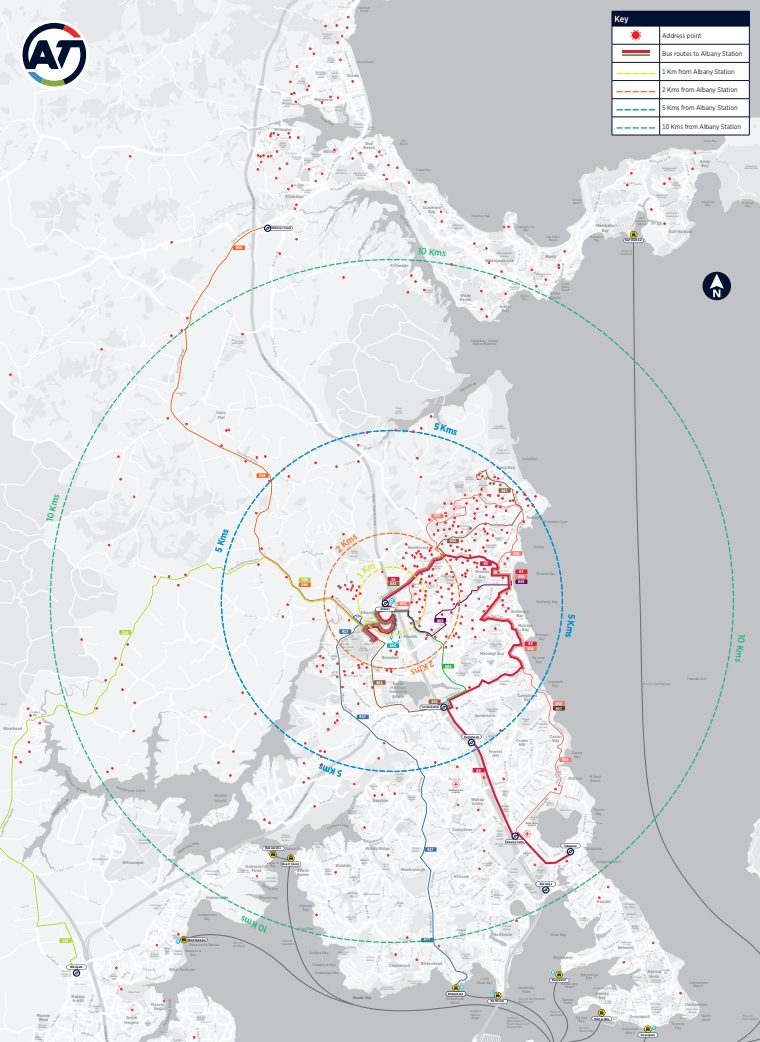
The next map takes a closer look, focusing on those within 5km of the station. It appears from this that many of those driving to the station live in relatively close proximity to a number of bus routes.

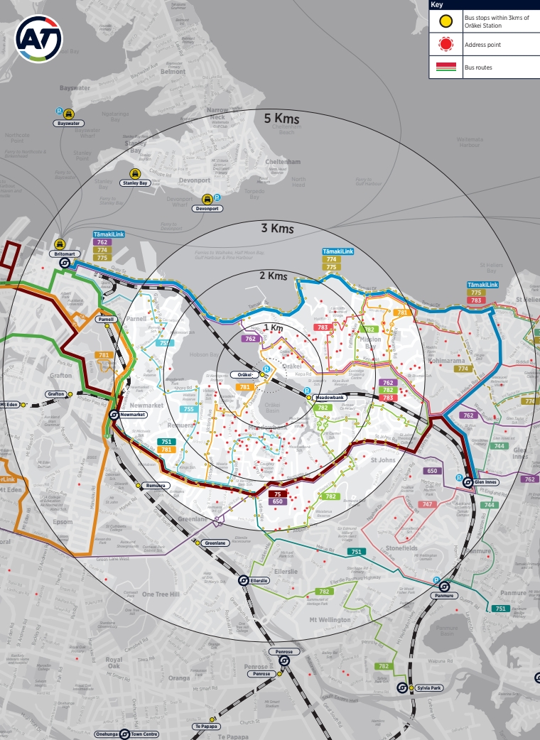
Orakei
The Orakei P&R is quite a bit smaller than Albany so there are fewer dots but again you can see most are clustered within 2km of the station, which would be very easily cyclable if AT were to put safe facilities in place. Some of the outliers are quite interesting too with them having driven past a few very frequent bus routes and even other train stations in order to park at Orakei.
Hibiscus Coast
Like with Albany, there is clearly a smattering of rural users at this P&R, including some from Warkworth, and unfortunately a bit hard to see on this map, but the vast majority are from the surrounding suburban areas.

Again it’s the 5km version that provides some fascinating insight. Like the previous maps, there appear to be quite a few people living on feeder bus routes.

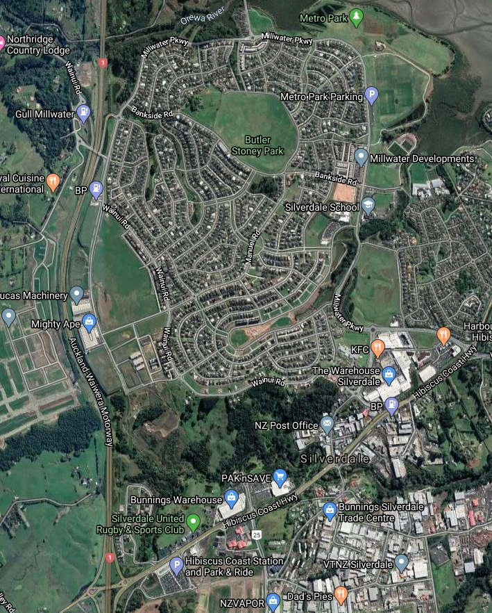
Another thing that stands out to me is the large cluster of users in the southwest of Millwater (just north of the station). Millwater is a classic example of car centric planning as the street network and urban form, such as the location of schools etc, means there is no easy way to thread a feeder bus through there that doesn’t either skip a lot of people or be so wiggly and slow that no one would choose to use it.
In all of these examples there are clearly a lot of people driving from close by who could easily get to the station by another method and it begs the question of what AT are doing to promote and improve these connections. Charging would help encourage this a shift too, and if nothing else, give AT another revenue stream. It seems strange that they’re so hesitant about it.
Related to all this, previously it has been suggested that charging for P&R happen by way of integration with HOP. Another interesting aspect in the response to Clr Darby was that AT no longer intend to do this. They say it would cost around $500k to do this and that it doesn’t stack up because most P&R users are already PT users – although this seems to be mainly in relation to stopping people not making PT trips from using the facilities. As such, any charging for P&R will by via their AT Park app and Licence Plate meters.
Developing P&R Stations
P&R is topical for another reason too. Recently AT have been visiting a number of local boards about ideas to develop some of the existing facilities, which they’re doing in partnership with Panuku. This has come about as part of an “Integrated Development Strategy” they’ve created. We first heard they were looking to develop some sites back in 2018.
The agencies have come up with 10 of AT’s P&R sites they’re looking to develop with any proceeds used for other transport projects. An example of the report to the local boards is here and in it they say:
3. Several credible development companies have enquired with Panuku Development Auckland and Auckland Transport about the prospect of partnering to progress opportunities. Potentially significant opportunities have remained untapped to date. Panuku Development Auckland and Auckland Transport have worked together to scope the opportunities which exist in the AT managed portfolio and develop a framework to progress the opportunities. Our proposed strategy seeks to integrate transport service requirements at designated council owned park and ride sites with mixed use development. The focus is on current park and ride sites which have the potential for the airspace above the site to be sold for development or another disposal component, while the underlying transport asset is retained in council ownership.
4. The Panuku and AT Park and Ride Integrated Development strategy seeks to achieve increased public transport patronage and strong urban regeneration and urban design outcomes at selected park and ride sites. It also seeks to increase density and intensification around transport nodes and provide the Auckland region with additional housing supply and a range of housing typologies
and
The objectives of the Panuku and AT Park and Ride Integrated Development strategy are:
- increased public transport patronage, active modes and safe access;
- strong urban regeneration and urban design outcomes;
- increasing density and intensification around transport nodes;
- increasing housing supply and delivery of a range of housing typologies as a priority;
- the ability to partner with developers capable of delivery;
- the release of capital / latent value from park and ride sites; and
- future proofing for imminent strategic transport requirements.
It’s good that Panuku are involved, when we last heard about this concept for Constellation was shown.
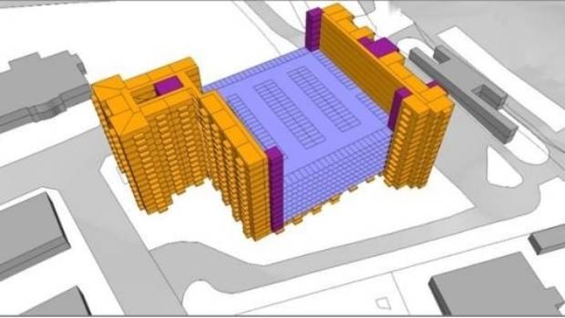
What worries me about this proposal overall is that like they’ve done in Takapuna in order to let Panuku develop the Anzac St carpark site, AT will likely try to use this process to demand an increase in the number of carparks as the base requirement. And with them only selling the air rights above the P&R, that we’ll end up with a bunch of townhouses, or maybe apartments plonked on top of a podium of carparking – much like was done at New Lynn.
I’m also concerned what message these kinds of developments will send. The council through its various plans wants more people living closer to and using high-quality public transport. These sites will of course be very close yet the people who would ultimately live in these developments are the ones who will be paying to allow those living in the suburbs to have free (or heavily subsidised) parking. They’re also the ones who will have to put up with the noise, emissions and local congestion caused by those people accessing the carparks. If anything it should be the other way around with the drivers subsidising the development.
The ten P&R sites they’re looking at first are:
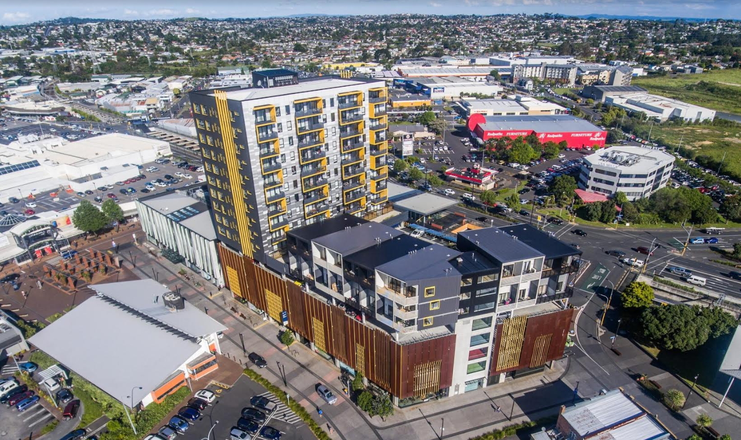
- Orakei Train Station
- Manurewa Train Station
- Selwyn Rd, Manurewa
- Homai Train Station
- Sturges Rd Train Station
- Papakura Train Station
- Constellation Train Station
- Albany Train Station
- Next to 20-26 Symonds St – this is where they want to build a large city centre bus station but haven’t yet been able to justify it.
Before any of this happens though, the first step needs to be that AT start charging for P&R. Doing so would give a better feel for just how much demand there is for more capacity and can also help financially contribute towards the construction of that capacity.

 Processing...
Yikes, analysis is very artificial by pigeon-holing people into buffer zones. Ggives some people a reason to exist.
The analysis is an interpretation of the data. The data is of real travel patterns as it relates to driving commutes and the users of PnR.
There is nothing artificial about it.
In an ideal world we would want people to leave their cars at home and catch the bus to the station. But today in Kapiti it is cold and the rain is pouring down. For most people to catch the bus they will have a walk quite a distance (in the dark on often poor footpaths) to the bus stop in the rain – then wait without any shelter for the bus – for a slow ride amongst all the other traffic to the station. I can see why they might want to drive out of their garage for a quick trip to the station. Maybe some/many would pay for this parking but at some price point they will instead drive on the free road and pay for the parking at their destination instead. It seems the whole system needs to be re-organised with proper road pricing, higher charges for parking in the city, fast feeder buses, good shelter at bus stops etc.
What they need is some kind of minivan that will pick you up from your door and take you to the local train station…
If an assumption was made Park n Ride added one zone for price (which also helps target those needing the facility), it would mean over $1 a day per park. At that rate it would be paid for relatively quickly. I also can’t see how a basic implementation could be anywhere near 500k.
This also promotes car share as paying per car.
All that is needed is allowing car plate recorded on AT profile, and a seperate touch pad for those parking cars, essentially they are simply transitioning like between bus and train.
The fact AT parking app seperate to hop card is another failure by AT which if done would add other options.
Ah, good idea
“What they need is some kind of minivan that will pick you up’
Auckland already has this service. It’s called a taxi, which will pick you up from your house, or a bus, will will pick you up a few hundred metres away. Try using the AT Metro Journey Planner.
That tower at New Lynn is an eyesore.
The tower is housing and is fine, the carpark stump it is on is absurd and unnecessary, it just generates driving through a supposed pedestrian space.
Transit Oriented Urban Parking is a profound stupidity.
That proposal for Constellation is truly ghastly.
Honest opinion; it’s like a carbuncle sticking out.
It might not be so bad if it wasn’t sitting on top of a car parking building.
In my opinion: They should build car parking on top of the station trench.
Albany and Constellation Drive were designed to be paid parking areas. A last minute loss of nerve by the Busy Project team saw them changed to free parking. They were worried about looking silly if too few people used the bus.
” Constellation Train Station
Albany Train Station ”
Wishful thinking there
Millwater is a clusterF in street design. Milldale will probably be the same.
However, looking at that map, there certainly is the opportunity to have a bus loop operate through Millwater and back to the PNR via Silverdale. It could operate along Millwater Parkway and Wainui Rd quite easily as these are relatively bigger straighter roads. It could even take in a notch towards the centre somewhere to provide a bit more coverage, but should be a fairly quick, easy, efficient service running in clock and anticlockwise directions if there is demand but just one direction to start with.
Am I missing something here? There’s already a bus (Route 985) which travels from Orewa to Silverdale P&R via Grand Drive, Millwater Parkway, Bankside Rd and then Millwater Parkway again. It only runs hourly (like all the other local services in the Orewa area) but it’s there. By chance I was out at Orewa yesterday (Sunday) and noted that there actually were a handful of passengers on it as well.
Yes, but hourly is not that usable. How much to run it half hourly verses all these P&R costs? Perhaps an 1/2 hr alternating slightly overlapping route would work there (where all those red dots are showing as people driving to the P&R).
Sorry that’s not true. Both have been masterplanned with AT public transport input on bus routes, cycleways and pedestrian access.
Millwater has masterplanned collector roads designed for buses that are accessible within a 5 minute walk. (Wainui, Millwater Parkway and Bonair Crescent). The curvilinear design matches the steep contour to create a terrace effect and maintain walkable streets. A grid layout could have been adopted but streets would be steep.
Milldale has a similar strategy with major collector roads connecting to Wainui & Silverdale.
The missing link is curly ave to provide a direct connection point to the busway.
So did AT say to the designers that at that density, the bus would only be hourly? Guess they didn:t need to. The designers would’ve been fools to think anything better could be achieved. Had they wanted an accessible development they wouldn’t have put it there.
The logic of the area was a transition of low density on the Orewa fringe then build towards another town centre in Milldale where higher density can be co-located with major transport route through Silverdale West the proposed industrial area.
In the short term the logic isn’t clear but when fully built out the area will be well connected to jobs and public transport.
Gee, that’s how they justify sprawl, is it? Even though the poor people living there are definitely stuck in traffic.
But can you answer my question – was AT honest that buses would be hourly? And did the ďesigners not care?
Rate of buses was not decided at that stage. The high level planning considers bus corridors and where bus stops are required. The demand drives the frequency and it evolves over time.
Curly Ave is a key road link from Millwater – P&R that I expect the bus could travel along. Developers can’t afford it and council do not have the money to do it. This is creating a barrier to an efficient link service, hence the use of the P&R.
So the success of the development depended on bus frequency, which would only be supplied if enough people needed it, which they wouldn’t because it was a low density development and the frequency wasn’t enough to work for anyone. And on something about Curley Ave -? – which depended on money… which there wasn’t.
And we wonder why we have car dependent development.
Gee, what will we tell the kids as carbon emissions soar? I suppose we say that some good souls tried to explain that transport is supply – led but the people making the decisions thought they knew best? And maybe that yes, of course we could only make a compact city by, you know, making it compact, but that in the old days people without the ability to see where things were going wrong and how to use logic were still allowed to make decisions.
But at least the decisions were made at the high level planning stage.
“Masterplanned” haha, haha, haaaa! Master planned by a child with a crayon?? Millwater is the single worst piece of road design I’ve seen in Auckland.
As for buses, even on the main roads in Millwater they have to swerve around cars on the narrow streets. It’s an absolute maze for pedestrians and cyclists who find it easy to get lost. It’s basically Albany loops on steroids but even worse.
Millwater Parkway, Wainui Road, Arran Drive and Bankside road are all full width roads that allow for buses to navigate easily. Parking is out of the live lane so buses will have no issue navigating those roads.
The narrow inner streets are designed in a way to create a slow speed environment through a meandering design with curvy roads and cars blocking lanes. These are not designed for buses and are local streets.
It also boasts one of the largest continuous shared pathways in Auckland connecting multiple schools, estuary, parks and shops (8km and counting). Masterplanned at the start.
Just because a road is physically wide enough to fit a bus on doesn’t make it a good route for a bus network. You only need to look at the torturous path the bus has to take through Millwater to see that. That design is not only long, indirect and slow, its expensive to run as a result. It also fails to provide decent coverage of the homes at the same time. Less than half the sites are in walking distance of a bus stop, it basically just bankside that has any service. The fact there are bus stops built on one side with no buses serving them, and a whole other side without any access to buses at all just shows what a planning failure it is.
Paths connecting parks to estuaries might look great on a master plan, but they’re pretty useless for anyone not taking a scenic jog. Most of those paths are in the middle of a grass median of a road that already has footpath either side, which is not only useless, it actually serves to make it that much further to cross the street and actually walk somewhere.
You could have tried connecting homes to bus stops for a start.
D- masterplanning, doing a 100% car based plan with some of the streets wide enough for buses and drawing on some squiggly paths after the fact doesn’t make it multimodal.
Ok it fails at good public transport and Density is lacking. This describes development in Auckland for last 20years.
What developments in Auckland have done better?
Apartments on existing bus routes.
Millwater provided $33million in development contributions for auckland transport. It paid for the park and ride. Necessary evil?
“It’s an absolute maze for pedestrians and cyclists who find it easy to get lost”
How do people who live in big cities in Europe or the USA cope?? Why is it that only Millwater cyclists get lost??
I have no trouble navigating around the Auckland CBD and most other places for that matter. I’ve managed to get lost trying to find my way out of Twizel a couple of times though, never underestimate a 1960’s style small town or suburban street layout!
Why not implement that you need to swipe your AT Hop card on entry and exit to P&R; or make use of the AT park number plate recognition app – Should be a single app in my opinion.
From there, AT transport make an analysis of what is the home address entered on the AT hop card registration and we can further understand the users using the park and ride.
This way, when AT transport do decide to implement paid peak parking, its easily implemented with no additional site work required, and we can understand the car users using the P&R are from afar or not.
I also have a few friends who live in Hibiscus coast, and park at Albany. Also offers a lot more carparks.
Maybe another discussion/post, but something I am sure is impacting Albany park & ride spaces would rather get close as possible via car to P&R, then take public transport, when they should be using Silverdale P&R.
We also need to make use of the Hooton Reserve carpark for P&R Albany just down the road. Why not have a small shuttle bus or minibus between Hooton Reserve carpark and Albany – even if its for peek times only. This can be paid for by implementing paid peak P&R to the carparks: Hooton Reserve carpark & Albany P&R
I think AT transport should show how these funds gathered from the AT park & ride are used for – such as a poster as your walking up to Albany P&R, showing AT park & ride Albany fees has paid 12% of new Albany to Constellation public transport extension, or 30% paid for maintenance on P&R car park, updated every 6 months.
Do we have stats on the feeder buses? That is, how many people currently board a local bus and transfer on the NEX.
It would be good to understand the recent growth there. You could also measure changes if they chose a pilot project foe PnR charging.
Excellent analysis and pretty damning of who actually uses the P&R. If that is not a case for charging for it, I don’t know how there could ever be. Surely AT should see the light here, particularly given it will give them a revenue source.
So AT should build a row of shops or units for various enterprises at the Park and Ride. For instance you could drop your car off in the morning and board your train or bus.The cars get a service, warrant or repair then you pick it up in the evening and drive off home no pain. Another one would be a laundromat same deal. Of course there would be coffee and food shop. Another useful thing could be manned drop off point for your groceries or for parcels so you don’t end up going for a drive on Saturday because you weren’t home to pick them up when the courier calls. Your car is there let the services come to it while you are commuting and working during the day. Less running around less congestion and less petrol getting burn’t and better for peoples lungs and better for the planet. Another potential use would be a depot for hire bikes and E scooters or a co-ordination point for ride share taxis etc. Just need a switched on outgoing person coordinator type to run it.
Wasn’t there (or still is?) a Countdown pickup your shopping service from a couple of the big stations they trialed a while back? ahhh yes Google:
https://www.countdown.co.nz/news-and-media-releases/2016/september/click-commute-and-collect
Don’t think it’s still running by the looks.
Greater Auckland = Northern Auckland ?
be good to see some southern P&R examples included. Where’s the data ?
Zero public transport where i live (Clarks beach) Busses scheduled for 2021? due to special housing area’s coming online. Ferry service is progressing. Park and float.
Probably they could provide at least an hourly bus direct to Papakura Station via Kingseat and Karaka. This is especially considering all the newer development along Hingaia Rd west of Pararekau Road which has nothing either.
Actually there is a 985 service M-F peak only (2 runs morning & again at night) for Hingaia Rd.
985 is a North Shore route
Sorry meant 395
Hard to see Clarks getting an hourly service when AT don’t even provide that level of service to Waiuku (with its much greater population).
I imagine that a Clarks Beach bus service would start with one or two peak trips and some kind of shopper service.
Yes Waiuku needs amping up also. Perhaps a Clark’s Waiuku Pukekohe service
Grant – it’s a shame AT can’t use the DMU’s on that route to Papakura .
Cost too much.
They could extend the 396 bus that currently runs 2 hrly from Pukekohe to Waiuku via Patumahoe to go to Clarks Beach then onto Papakura as well. Another earlier and later service perhaps. This service is obviously not targeted to city bound commuters with the start time of around 8 am.
This could work in with a few more runs from the peak only 395 Waiuku to Papakura direct service.
Just to comment again that the Waiheke ferry car park (Matiatia) is a park and ride (or park and float as South Auckland Rules puts it above). And it has cost $6 a day to park in it since ages ago. It still gets full.
How much should P&R cost in the places mentioned in the article? The same rate for all of them, or differential pricing depending on location, demand, what have you?
It’s been on GA before, but can someone please remind us of the actual cost of providing some of these P&R the parking spaces?
Yes, I think the costs were pretty high, but it would be good to hear what they were again.
Do they need to charge more at Matiatia to make sure there’s a park available for people who really need one or do they need to provide better footpath to the bus stops, and better shelter?
Better bus services would help reduce car demand at Matiatia. They’ve made some bus improvements, which will help many. (But my road used to have a bus route and now doesn’t, so I’m a long way from a bus stop and it’s not practical for me to use the bus except occasionally).
Yes, they do need to charge to manage demand. Perhaps it will have to increase to more than $6 to make sure there are parks for those who really need/want them.
They should also surface and paint lines in the somewhat hick free car park, which is 10 minutes walk away from the ferry. Currently it’s a bit hazardous to drive and walk on sometimes (it’s a bit steep for gravel) and people squeeze in where they think there’s a space and inadvertently block other people off from leaving sometimes too. There are no markings at all and it’s an irregular shape, so one has to guess where to park.
I’ve just thought: If they ever do anything about the exorbitant ferry prices (PTOM review anyone?) that’s going to put a lot more demand on the car parking as the high ferry ticket pricing limits travel currently.
“I’ve just thought: If they ever do anything about the exorbitant ferry prices ”
The Devonport and Waiheke services were granted an exemption by the last government from inclusion in the city’s council-controlled public transport system.
This is the price that you pay to live on a remote island. Why should Auckland Ratepayers subsidise your ferry ride?
Bus Driver ;- So Devonport is now an Island ?
A (probably out of date) estimate was $10,000 per park for a multi-storey parking building.
One at grade like Orakei’s is, is still expensive per park, probably at least $6k per park. As paving doesn’t last forever. And of course, there is also an opportunity cost of using that land for all day parking for a hundred or so cars, rather than some other activity (that generates revenue), be that P&R, or commercial development.
There are collection/enforcement costs for a P&R to allow for.
But at $10K per park, if you charged $10 a day per park and it was used 220 days a year (all working days except public holidays more or less).
You’d get a gross amount of $2,200 a year from that park.
So in theory it would pay itself of in about 10 years, depending on collection and enforcement costs.
Still, thats optimistic. Not every P&R park is full all the time.
Orakei is a special case currently because its in effect an extension of cheap parking for CBD workers, being only 2 stages each way from town.
So currently, its the cheapest all day parking available – for the cost of a 2 stage HOP fare each way. Plus a drive to/from the station.
And with Orakei itself those from Orakei , Mission Bay and Kohi have this long walk up the hill next to a busy stretch of highway with no shelter as there is shelter as such going the other way into Remuera .
That’s decades out of date.
Surface level carparks are about $10k per space – although some can be nearly twice this.
Multi-storey carparks are about $50k per space
Greg, the NEX PnR would be full more like 250 days per year (weekdays less some public holidays and Xmas period). Even on the weekends they’re still half full or more generally so you’re really looking at more like $2800 pa per park cutting that time frame down to 5 or so years.
Fraggle the council is still trying to claw back the Millions they paid for the piece of land they bought were the carpark is .
And you could use the old Woolies carpark which is free ans at long last the have reinstated the old bus shelter to keep you dry .
Shouldn’t that be true of every council car park that’s being used for P&R? I mean, they bought all of it…so why not charge for the parking if they want to claw back the money?
I support charges for the Matiatia carpark…but not quite so much when they aren’t charging for any other park and rides.
NB old Woolies carpark would be park and ride (and wait) and ride, which is getting to add a few too many transfers and waits – before even getting to the downtown terminal and onward travel from there…
Just a point about transport to Manurewa Station.
Where I live one doesn’t walk at anytime of the day. 25 mins to the station, 10 mins to Mahia Road for the hourly 361. It ain’t safe to walk at all.
That is a terrible indictment of postwar planning in Auckland.
So the success of the development depended on bus frequency, which would only be supplied if enough people needed it, which they wouldn’t because it was a low density development and the frequency wasn’t enough to work for anyone. And on something about Curley Ave -? – which depended on money… which there wasn’t.
And we wonder why we have car dependent development.
Gee, what will we tell the kids as carbon emissions soar? I suppose we say that some good souls tried to explain that transport is supply – led but the people making the decisions thought they knew best? And maybe that yes, of course we could only make a compact city by, you know, making it compact, but that in the old days people without the ability to see where things were going wrong and how to use logic were still allowed to make decisions.
But at least the decisions were made at the high level planning stage.
Try this for a park and ride spot on the western line today ;-
https://www.facebook.com/akltransport/photos/p.2639646496363801/2639646496363801/?type=3&theater
And how do rate this ?
If that happened we would go back to driving, we have started using the Glen Innes Park and ride, for two of us it costs just over $15 to take the train each day, we live on a bus route that runs every half an hour but actually turns up +/-10 mins of its timetable time, so if you just miss one you can wait up to 40 mins for the next one, so we drive to the train. (We are not cycling as I don’t want to be sweaty when I get to work). We can drive to the city, and park for $15 a day no stress, and only pay petrol. Timewise it is very close so any additional costs for using PT would put us back on the road.
There is only one bus an hour to Hibiscus coast station, clearly that is not convenient and if anything goes awry with that one bus the whole journey is ruined, no one can take that sort of chance, especially not to get to work.
I’ve tried to use the Orakei park and ride several times however it was full by 7:30am. Even though I live 2.5km away from it there is no bus I can take (without a 15 minute walk). I have a disability and biking isn’t an option. So I normally drive to Newmarket and catch the train there. I would prefer to use a bus/train combination via Newmarket however the transfer from train to bus to get home is far too unreliable.