Yesterday Auckland Transport removed a section of temporary cycleway on Tamaki Dr, despite only days earlier quoting a 91% increase in the number of bikes on their counters.
In a response to Waitemata Local Board member Graeme Gunthorp they said they removed it because of an increase in trucks and safety concerns and as such, cyclists would need to once again share the narrow shared path with pedestrians.
Hi Graeme, the majority of the pop up space of Tamaki Drive is not being removed. We have removed a the section between The Strand & Solent Street, in light of the safety concerns raised with the increase in truck activity. Additional signage will be placed on the shared path.
— Auckland Transport (@AklTransport) May 4, 2020
The issue seems to be that trucks accessing the port are used to racing down the rise from the Strand and sweeping through the slip lane at Solent St. There is currently no zebra or even light controlled crossing of that slip lane so trucks can travel at speed through here.
AT rolled out the temporary cycleways pretty quickly and I’m happy to accept this section may have had some flaws. But if an increase in trucks, presumably treating the intersection as they always have, is causing a safety issue, AT should have redesigned their temporary installation, not removed it all together.
As you can see with the video below, even without signs on the shared path it is already too narrow and with them is basically single file in places while there are six lanes on the road next to it.
https://twitter.com/seen_in_ak/status/1257177682871123969
The whole thing really makes me question AT’s priorities and their commitment to vision zero – which they themselves state people make mistakes so “it’s the responsibility of those who design and operate the transport infrastructure to provide a safe system“. It also increases the chance we’ll see more sections of Tamaki Dr and other temporary installations chipped away at fairly quickly. That would likely leave the Queen St changes as the only ones we’ll see any lasting change for and that would represent a massive wasted opportunity.
The issue of priorities was also highlighted yesterday as at about the same time as AT confirmed the section of Tamaki Dr had been removed, they announced they would build the Matakana Link Road as a four-lane road because the community want it. Granted, the decisions on Tamaki Dr and Matakana Link Rd come from two different parts of AT and are unrelated to each other but it certainly doesn’t help the impression that they are far more responsive to calls for more car capacity and not responsive enough to issues such modeshift, climate change and safety.
The project in itself isn’t bad as it gets cars heading to Matakana and nearby beach areas out of the notorious Hill St intersection but it does reinforce the notion that the Puhoi to Warkworth motorway is actually more about serving that traffic than it is about improving connections to Northland.
Matakana Link Road is being future proofed with the capacity to allow for four traffic lanes along the full length of the road.
Auckland Mayor Phil Goff says the extra lanes are something the Warkworth community has been asking for.
“Auckland Transport (AT) has developed a plan that will allow all four lanes of the Matakana Link Road to be built within in the existing $62 million budget,” he says.
“Building four lanes from the outset will ensure that the new road can accommodate growth in the Warkworth area, which is expected to see a population increase of 20,000 over the next 30 years.”
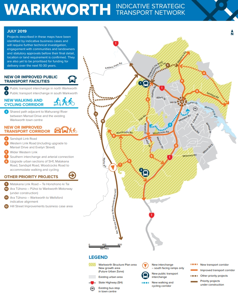
Matakana Link Road is a 1.35km link between State Highway One and Matakana Road. This route will provide an alternative around the frequently congested Hill Street intersection for traffic heading to Leigh, Omaha, Sandspit and Snells Beach.
Rodney ward Councillor Greg Sayers says the news is a “double win” for the local area.
“I am extremely pleased that the four lane option has finally made it across the line. When completed – this new road also creates an alternative traffic route, relieving pressure on the Hill Street intersection allowing bulldozers to finally go in and build a permanent fix with minimal disruption to everyone.”
……
AT’s Executive General Manager of Integrated Networks, Mark Lambert, says AT is looking to have the road built in time for the opening of Waka Kotahi NZ Transport Agency’s Pūhoi to Warkworth project.
“Preparatory works started last week – prior to the main construction works – and involve lizard trapping and relocation, tree felling and service relocations on Matakana Road.”
The project will employ up to 120 staff over the construction period and the work will include provision for safe walking and bike riding. AT is also building a new bridge which will involve the removal of vegetation and some replanting.
AT will ensure that any wildlife in the area is relocated safely.

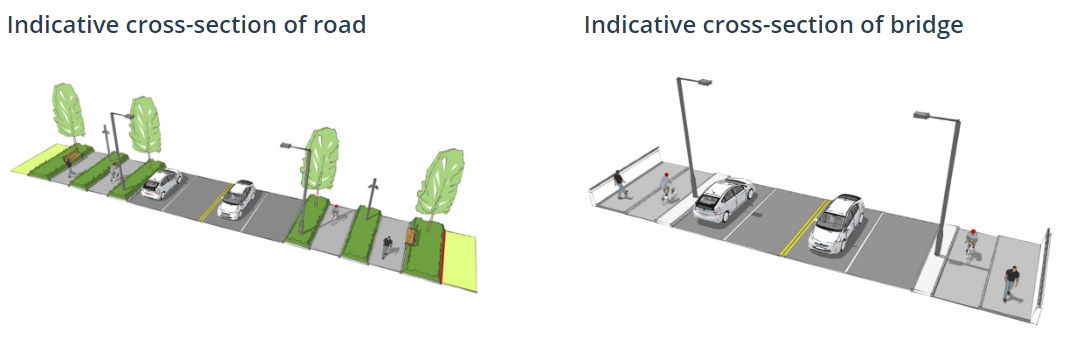
That AT have done this without increasing the budget is somewhat positive but I am concerned as the press release also mentions there will be a shared path alongside the road when the previously agreed plans had separated walking and cycling facilities – the previously announced cross-section is below . More road lanes at the expense of proper walking and cycling facilities is not a great outcome. Furthermore, ATs modelling suggests the traffic capacity of a four-lane road is not needed for 20-30 years. Building that capacity now risk encouraging more traffic sooner and also that traffic driving faster, especially as there are currently no intersections planned on the road.
I also still don’t understand how a four-lane, 50km/h road is going to cost more per kilometre than the Puhoi to Warkworth motorway, a project that includes vast amounts of earthworks and viaduct structures.
Finally, while it doesn’t change any of the comments above, it’s worth pointing out that while Warkworth could grow by 20k people over the coming decades, most of that growth is south and west of Warkworth, away from this project.

 Processing...
Worth pointing out that this is the side of the road that the Glenn Innes cycleway is going to feed people into. It’s going to become an extremely busy piece of shared path. This side of the road doesn’t really matter for the bulk of Tamaki Drive but it’s going to be super-important shortly.
As stated previously, the whole length of Tamaki Drive needs to be reviewed through the same lens that finally saw action on High Street. In any other city in the world, a piece of coast like this so close to the city would a jewel in the city’s crown. If this means extending the sea wall, removing car-parking or adding a boardwalk to open up some public space in places, then let’s talk about it now. At some point we’re going to have to redo the bits that flood, we might was well get some really decent outcomes from it that at least make it safe to use.
100% agree but good luck with the local politicians, business associations and vocal residents. Plus fighting the Port to allow safe transit across Solent St.
Another good reason to get POAL out of there!
Downers have started a $14.4m construction to raise the flooding section by 0.5m and take the bike path to the seaward side, with bridge clip ons and reduced parking (unfortunately not all parking). The GI cycle path will be taken to the seaward side at the Ngapipi lights:
https://at.govt.nz/projects-roadworks/tamaki-drive-improvements/tamaki-drive-cycle-route/
https://at.govt.nz/projects-roadworks/glen-innes-to-tamaki-drive-shared-path/
Are those cross sections what they planned on the left and what we’re now getting instead!? We’re doomed aren’t we? Seriously AT are giving in to some ‘people’ who want to race to the end of life on earth, so they can get to the pretty beaches without being bothered by trees along the way… fighting for nothing but concrete and tarmac….I can’t even. We fukt.
It leads to a long country two lane road, shouldn’t we be calming these drivers down on the way to their holiday, not enabling the continuation of m’way style driving behaviours? – this is how the world ends- with excessive road capacity.
They’re going to have to put a permanent speed camera there.
I also don’t understand why they bothered? It’s a restricted access arterial with separated cycle path. Put in a narrow central median and make it 60 km/h. With 50 km/h your going to get terrible speed compliance and people will have no idea why you posted it at 50.
Typically, this matter could not be considered without supporting bikes rather than cars and trucks, with an obligatory reference to Climate Change! Surely they could have squeezed in a reference to Sea Level Rise, just to complete the propaganda?
Do you believe in pandemics?
For the link road, the 2 lanes heading towards the beaches will at least reduce the long queues that will back up at the roundabout at end of the Puhoi to Warkworth section. It would have been better if the link road directly linked to the motorway though to better clear the traffic, as I still see the queues blocking traffic heading north – much worse and more often than the queues at the tunnel due to the roundabout which of course was designed assuming Warkworth to Wellsford was going ahead.
If they’re going to go ahead with this, they need to improve the Hill St intersection at the same time, by closing Matakana Rd there. Making that intersection safer by lowering traffic volumes was probably seen as a positive of this project, contributing to the business case. But there are a few reasons why in a few years, the traffic going through the intersection onto Matakana Rd could be as bad as it is now – or not sufficiently better to warrant the project at all:
– they have not properly included the level of traffic that will be induced by the Puhoi to Warkworth motorway nor by this Matakana Link Rd, because their processes are set up to systemically ignore this.
– the roundabout where the new link road meets Matakana Link Rd is at the pinch point where many lanes go into one. With priority given to the traffic coming directly from Warkworth along Matakana Link Rd, more traffic will take the existing Matakana Rd than if priority was given to the new road.
– this new road will be seen as a reason for rezoning land into new subdivisions, in the usual roading sprawl development pattern we know so well.
I completely agree here. Hill Street should be changed to a single lane oval roundabout. Matakana Road should be closed at the bottom of the Hill. There is going to be a massive reduction in traffic there, so we need to lock in the benefits of that.
Agree. It really looks like a disconnect between NZTA motorway design and AT with the link road connection and design. I think every long weekend people will soon realise that it will be better to exit at Puhoi and use old road, particularly if you are going to Sandspit direction but even Matakana as you will have priority over motorway traffic.
Roundabouts don’t work when there is uneven traffic flow. Look at the improvement now (well pre convid) at the airport once they changed to lights.
It is the same issue with traffic from Warkworth heading north via SH1 having priority over traffic exiting the motorway for Warkwork/Matakana.
The new roads will induce traffic, but also concentrate/move the bottle neck so ironically make things worse than now (well should improve Warkworth centre)
Yes completely agree too. Lock in the benefits and allow the new roundabout to work better by closing Matakana Road at the bottom of the Hill. How can we get this happen, need a local or Greg Sayers to campaign on this. Perhaps he needs to meet up with someone who could show him the benefits for the town of doing this.
Why do the trucks need to travel on the Tamaki drive could the port company build a ramp so they would directly enter the port from the intersection.
Yes obviously that should be straight through to the port rather than that dangerous dogsleg with so many competing users, but is claimed as port traffic only by PoAL. Instead of building car parking buildings they should fix that intersection.
I had a quick look on street view and couldn’t really get the best of views as there was a large container truck blocking where I wanted to look.
I agree this is an option that should be looked into.
Why do road works signs get placed on paths at the sides of roads, blocking half the path? Its been the same on Ian McKinnon Drive for several months. I was cycling behind a woman who crashed into a sign there.
Surely there is more space in the road lanes?
I thought the Matakana link road was going to line up with the motorway access. Looks pretty dumb to route what will likely become the main traffic flow through two 90 degree turns
“Why do road works signs get placed on paths at the sides of roads, blocking half the path?”
Answer: to provide exercise for the populace in a time of lockdown so we can relocate them to verges – the place for signs and car parking.
Clearly I’m no engineer, but I hoping someone can jump in here a let me know if this idea has any merit. Could the problem of port trucks on Tamaki Drive between The Strand and Solent be fixed by constructing a ramp within the port land up to The Strand intersection? Making this a signal controlled 4 way intersection where the majority of trucks would be expected to enter and exit the port straight onto the Strand/Stanely state highway and motorway system. Could then the Tinley St and Solent St gates of the port be restricted so that heavey vehicles would use the new heavy vehicle gate and they wouldn’t continue to randomly clog other roads in the CBD?
You could do that. You would build it parallel to The Strand on what i think is called Sunderland Street, then have a corner at the top to connect in to the existing intersection. It would require port land to do what they currently do within a public road so the Port would probably oppose it.
The port company are proving very slow to understand social licence. It is this, in my view, that condemns the port to move north, or anywhere, it is being run as if the city is there to serve it, and not visa versa.
Why would they oppose getting their trucks out of a bad conflict zone with the public? It defies all reason. Not only is it immoral; it’s just plain stupid.
+1 I think the port will complain that it affects operations too much, but at the very least they could create a one way (inbound) road to take any vehicles turning left from Quay Street or straight throungh from the Strand. Then Solent Street would be outbound movements and right in only, all of which could be signalised. This would avoid the current dangerous slip lane arrangement and give them a signalised place to cross the proposed cycleway.
+1
Surely if the Port wants to remain in the CBD for the forseeable future – which they most definitely do – they need to be a “partner” with the city and start giving a little on things like this to improve the CBD and address negative views of their impact?
Although in reality, they would probably only provide it in exchange for more harbor infill.
Yes good discussion on this. The Port talks big on climate change and its proactive changes and plans in doing their part as a “good citizen”. If this is true then making it safe for cycling & active modes along here should be something they can be doing to help encourage more of it.
Yes, it’s the obvious thing to do. And the Council needs to direct the port to do so. AT will still need to reallocate the northside traffic lane to walking and cycling as the shared path is inadequate even if the trucks cross over it at an intersection rather than turn and drive along it.
To fulfill its responsibility to provide a safe transport network, AT should have removed the traffic lane years ago. The port wouldn’t have been happy but it would have pushed them to redesign their entrance as you’ve suggested.
This recent decision demonstrates yet again that AT doesn’t understand whom it is they are serving.
Does everyone remember that the creation of AT was originally hailed as a breath of fresh air, because political control (by the then ARC) had led to stasis, motorway madness, and politicians holding the system to ransom over pet projects?
If we had a Right-wing, pro-car anti-PT anti-cycling Council majority and mayor again, I bet we’d be defending AT’s independence.
It’s their apparent belief in independence from their responsibilities that’s at question.
They are required to provide a safe system. They’re not doing so.
I still support AT’s independence, but they have to show they are really following evidence and being pro-active, no longer captive to broken traffic models and vehicle Travel Time savings as the only metrics. Or as a veto on change (this still looks like the case).
Additionally there does need to be clear leadership from the Mayor; look what Brown achieved in much more trying circumstances. Getting the city, and especially our streets, climate appropriate should be Goff’s mission and legacy…
There will always be tension between the political and the technical levels, but this should be productive, it’s best each stays in their lane, while fully understanding of the other’s role. The political needs to set the strategy, the why and what, and the technicians the how. Getting on with it, with way less foot dragging and hand wringing.
I reckon Len Brown should stand again – I’d vote for him!
Just been along Ponsonby Road and its an absolute s**t show, if that’s tactical urbanism then we are all doomed.
Instead of replacing on street parking with cycle lanes, then have just put cones out where the parking was and shunted the parking into the traffic lane, with signs Pedestrian and Cycles one side of the cones ‘Parking for local business’ the other. Nobody wins here as it is impossible to park in the middle of the active lane of traffic and Aucklanders being who they are, are simply moving the cones and parking lanes (I spotted people doing this the other day).
Wherever there is already consent for a cycling lane (has gone through all the ridiculous amounts of consultation) then they need to get some physical planter boxes and yellow paint and start fast tracking. This throwing a load of cones out for a couple of weeks till we move to L2 is helping nobody.
I would agree with many of the points made above.
On Matakana, surely after the massive behavioural changes observed in Covid 19, future business activity unknown, and immigration based population growth stalled for up to two years, previous traffic growth modelling is now suspect. Would it not be wiser to wait till the Covid 19 restrictions are fully relaxed and we can see where the economy is at before deciding on four lanes?
If a decision must be made on Matakana now (why?) AT should build Matakana as two lanes, designed to be expanded to four lanes in future, if and when that capacity is actually needed.
Interesting re Matakana Link Road. You will note the fully separated walking and cycling facilities on both sides of the road – some may see the provision to the north as being not needed right now, as there is no development there as yet. But to be honest they might as well do the earthworking for it all at once as it would be a pain to try and do it later. Ditto the bridge – might as well build it once. Not sure how they managed to get the cost down other than land acquisition being less than they allowed for.
It may well cater for the Omaha/Matakana set during the weekend (of course it won’t solve the Matakana weekend congestion) but it will definitely help those that live at Snells Beach and Algies Bay, who are often caught up in queues to Hill Street by mid-afternoon.
Design-wise, the road currently lacks side friction (it will have up to three intersections to service future development on the northern side) and I agree the four lane configuration will encourage speeding despite what I believe will be a posted limit of 50km/h. Ideally there should have been a raised median in the centre and some parking along the edges – or just keep it to two lanes.
There’s no doubt that if Puhoi to Wakrworth is going to be of any benefit at all, this link will need to be built – but it does little to address the need to dramatically lower our carbon footprint. I’d be more convinced if the walking and cycling paths actually connected to something meaningful.
“Phil Goff says the extra lanes are something the Warkworth community has been asking for.”
The developers and land-bankers of Matakana and surrounding areas, yes. Omaha beach-house owners, sure. Anyone in the Warkworth community, I highly doubt.
This expensive extra bit of road perfectly justifies why the whole boondoggle was called the Holiday Highway.
“Auckland Mayor Phil Goff says the extra lanes are something the Warkworth community has been asking for.”
So what are you saying Phil? That you are a ballot box politician?
What about the 50% odd of the population that are saying, you need to be doing something about carbon emissions? Auckland Council doesn’t even seem to have the semblance of a plan.
“Building four lanes from the outset will ensure that the new road can accommodate growth in the Warkworth area, which is expected to see a population increase of 20,000 over the next 30 years.”
So not only does Auckland Council plan for emissions to grow, but it seems to continue to grow.
Has Council learnt nothing from the Covid crisis that a world out of balance is likely to beget more problems. Hell, Auckland is bumping along the edge of a climate caused water crisis and we don’t seem to care.
What is most distressing is that Council’s target for emissions reductions by 2030 is 30% above the scenario recommended by the C40 city organisation. I truly fear for the future of my 20 something year old kids.