We’re living through some fairly extraordinary times of late but there there have been some silver linings. It’s been incredible to see families out together during this time. Normally quiet neighbourhoods are bustling with people walking and cycling. Even many normally busy arterials have until now been so quiet that families feel comfortable enough riding on them with their children. It has shown there is a huge latent demand for better walking and cycling facilities.
That’s why we’ve been critical of the response we’d been seeing from Auckland Transport and other agencies. As well the need to provide more safe space all the people walking and cycling, many places have been seeing more people on bikes than in cars, we should also be looking at how we can lock in some of changes. Afterall, getting more people using active modes on a more regular basis is part of the city’s and country’s goals.
So it was great to see on Friday that AT had started to roll out the first of what is hopefully many changes – I just wish they had communicated they were going to do it earlier.
Temporary Cycleways
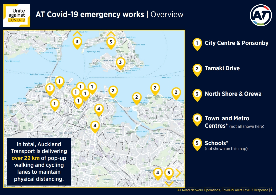
On Friday, Auckland Transport started to install the first of as of this morning should be 17km of temporary walking and cycling facilities – although their accompanying map suggests 22km
Auckland Transport (AT) is delivering the first of a rolling set of initiatives on 20 roads and popular walkways across Auckland to assist with safe physical distancing when the country moves into Alert Level 3.
By Tuesday, 17km of temporary cycle space will be installed across the region.
Tamaki Drive (between The Strand and St Heliers Bay) will be the first location to benefit from the initiative, with the measures being installed on Friday morning where the pathways are narrow. Carparking on the sea side of the road will be temporarily removed and replaced with a wider space for people walking or cycling, giving Aucklanders the ability to keep 2 metres apart from each other’s ‘bubbles’.
AT is trialling these as temporary measures, providing the ability to adapt available space on the road to reflect their use by Aucklanders during different alert levels.
Here’s an example of what they’ve installed on Tamaki Dr. This is a good start from AT although it feels like it should be wider.
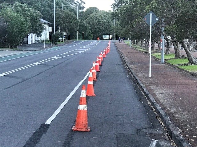
Also, the (initial) implementation was a little lacking with signs blocking it on a regular basis.
https://twitter.com/jdeheij/status/1253878905615745024
However. the advantage in this being done with such quick and cheap materials is that it is very easy to change and AT have apparently already told the contractor to do so. I also appreciate this is a bit of a learning experience for both AT and their contractors and so assume things will improve the more that they do.
The good news yesterday was that it appears they have learnt and on Oteha Valley Rd they’ve given cyclists a full lane each way.
On Oteha Valley Road, the extra space for those walking or using bikes is in place! One lane repurposed in each direction, 30km/h safe speed applied. pic.twitter.com/0CYTdWMq7F
— John (@johnage) April 27, 2020
Other initiatives to support the increased number of people walking and cycling across the city are also being rolled out. Signage and markings reminding those out and about to maintain physical distancing have been installed and most pedestrian crossings switched to auto-mated, reducing the need for people to touch the request button.
Included in the rollout for widened spaces are temporary emergency safe speed limits where applicable to increase safety for all road users. With more people driving to get to work and freight services returning to normal it is expected that roads will be busier than what they were at Alert Level 4.
Other locations Auckland Transport is installing new walking and cycling measures:
- Queen Street
- Quay Street
- Customs St/Queen Street intersection
- Ponsonby Road
- Oteha Valley Road
- Lonely Track Road
- Mangere town centre
- Otara town centre
- Manukau town centre.
AT will continue to roll out these temporary measures on a responsive risk based approach and is responding to local boards’ requests for safety-based interventions.
Auckland Transport is also reminding people who may return to using their car to be aware of vulnerable road users when they travel. More than ever people are using their road space to walk or use a bike, and as a collective Aucklanders can all play a role in keeping everyone safe.
I still wish they would put some signs up on traffic lights to let people know that crossings are on automatic. People are still pushing buttons because they can’t tell which intersections are and which ones aren’t. I also like how they’ve adjusted their safety messaging from last week.
What isn’t quite clear at this stage is what happens when COVID restrictions are lifted. Are AT going to suddenly rip out all these new temporary improvements and put an end to the bike boom, is parking cars along the waterfront going to be considered more valuable than safety? Alternatively, do AT start working to changes permanently. I think that over the coming weeks AT are going to need to explain what the process will be.
Queen St Closed to cars
One of the most exciting changes coming from both AT and the Council is that the Queen St works include first section that I understand will become bus and bike only. This first section is only between Customs St and Shortland St but it’s a start and hopefully should quickly extend further south. It seems we could be getting the first parts of the new City Centre Master Plan implemented much faster than previously thought.
The emergency response initiatives rolling out to support safe walking & cycling on Queen St, Tamaki Dr, Ponsonby Rd, Otara & Manukau centres, & schools are just an appetiser. Hang around for the main course – Innovating Streets and speed limits that don't kill. You'll be smiling pic.twitter.com/5oJTgd2qzl
— Chris Darby (@DarbyatCouncil) April 26, 2020
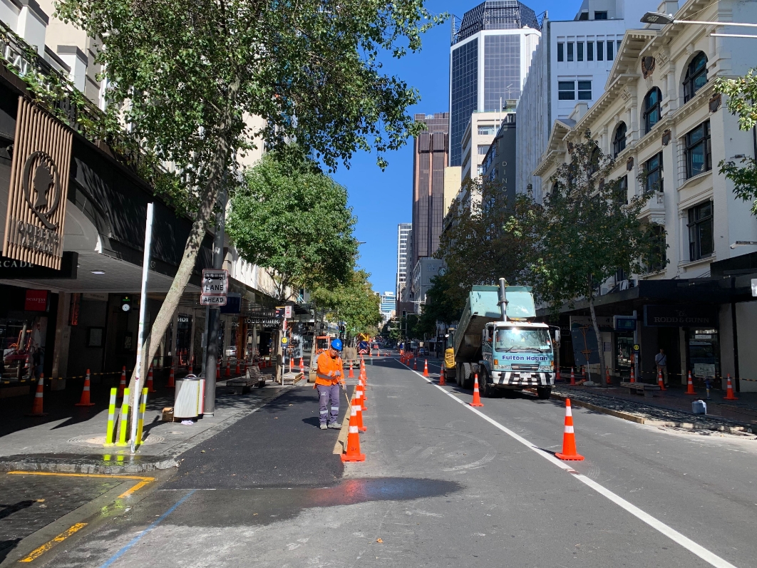
I look forward to seeing more of their plans for Queen St
Pick up zones
Councillor Chris Darby tweeted out these signs that will be rolled out
As fast as they can @AklTransport is rolling out local business pick up signage in anticipation of a big lift in online shopping and need for courier (and private vehicle) collections and drop-offs. pic.twitter.com/nCsNjIjdeH
— Chris Darby (@DarbyatCouncil) April 27, 2020
What next
We’ve long been fans of the idea of open streets, also sometimes known Sunday Streets or as Ciclovia in the city that pioneered it, Bogatá, Columbia. The idea is a simple one, once a week turn the many of the streets in the city over to those on foot and on bike.
It doesn’t have to be a big organised street festival, like the few times we tried it here have been, just get the cars out and let people use the streets as they wish. The lockdown has given many of us a taste of that could look like.

Dominion Rd

Meola Rd
https://twitter.com/kentslundberg/status/1253582219689340928
It must be the sharrows pic.twitter.com/g6rDP0Qa9Q
— geogoose (@geogoose) April 26, 2020
Misc pic.twitter.com/n7vQQdB3kS
— geogoose (@geogoose) April 27, 2020
We need Auckland Transport to start coming up with ways to enable these kinds of scenes to be seen everyday – and that’s something we’ll focus on a lot in coming weeks, months and years. But in the short term, how about we start by just opening streets every Sunday. By opening streets I don’t mean the heavily curated 1km like we’ve done before, but more like the now 120km that Bogatá does every week, and needs be spread across all corners of the city.

 Processing...
Wonderful start! Gracias AT and councillors!
Having seen what is actually planned for the ‘town centres’ eg Otara, Manukau I take the announcement with a grain of salt. Majority of it is signage warning people to stay 2m apart.
Centrally the focus looks to be on the routes into the city rather than the suburbs. Will be interesting to see what comes, however kudos must be given for something happening.
I am heading to Manukau this morning to check out what AT have done
Will report back with Photos
Yes please. Photos?
I couldnt do any photos as there was zero meters of any tactical cycleways done in Manukau
Maybe tomorrow. Fingers crossed.
Interesting. Your map at the top seems to just show rich white person land. Waitemata shoreline. Do you have, or does AT have, a map for the vast rest of Auckland, especially the poorer land further south and round the Manukau harbour? There’s a lot more to Auckland than what is shown here.
That is ATs map, the only one they’ve put out so far
Lmao Tamaki Drive gets some road cones – the first improvement in cycling in about ten years – and someone complains about it.
That’s the area the Super City was set up to benefit. The rest of us only exist so they can collect rates to spend in that area.
It only takes a short walk in the city centre to confirm this is actually true. Observe the contrast between:
Wynyard quarter → rich people
Victoria quarter → poor people
You should probably remind the Council of that then. Last I checked, Central East Auckland still had fewer bus services than it did five years ago, Tamaki Drive still floods, there’s no east-bound bus lanes (not even a clearway), the ‘shared path’ is not fit for purpose after it diverts to GI for the cycle-way about 10% of the way along and the beaches are unusable after a decent downpour. Still get the stonking huge rate-bills though.
If the Council is meant to be lavishing money and upgrades on Tamaki Drive as a core order of business, then it has failed abysmally and should be dissolved.
Hell, if I can convince anyone to give Tamaki Drive the same treatment as any other beachfront promenade in the world, I’d be over the moon. But if people are going to froth about class when someone puts some cones out, what chance do we have. Let me know when a Council “waterfront” plan goes further east than the Port, looking forward to seeing these streets of gold we must be getting any day.
That struck me, too. It does say:
“Town and Metro Centres (Not all shown here)”
and clearly there are works happening elsewhere. Hopefully the next step will include maps across the whole city, showing clearly an equitable spread of safety measures.
I guess is that those living in “rich white person land” pay more rates than “poorer land further south” so maybe deserve more services.
Or is it that the MAWMILs have spoken.
A good start… can AT also close vehicle access to large parks and reserves such as Cornwall Park/One Treel Hill once a week? it has been great to see families going out on their bikes and scooters. Parks ain’t supposed to be designed as throughfares.
I also noticed on my short bike ride this morning at 7am, there are more cars/utes, and some of them are driving rush and fast. The good gain of safer roads for all during the lockdown can easily be lost.
The Domain should be number one to be closed at weekends at least, if not permanently to through traffic.
Why are cyclists still (illegally) riding on footpaths when the roads have never been safer? And the footpaths have never been more unsuitable for cyclists due to large numbers of people perambulating!
Do you mean closing it to through traffic or totally removing vehicles past the gates?
I think that both the Domain and Cornwall Park could be made with “filtered permeability” – by this I mean that cars can enter but not drive across the Parks and bikes and walkers can. The Domain is a regular rat-run from Remuera and Parnell to the City as is Cornwall Park a short-cut to Royal Oak.
I applauded the initiative for Cornwall Park to stop this thoroughfare in the mornings (pre-lockdown), but I can see no reason for it to be opened at all. Possibly Cornwall Park could do more to make it filtered on bikes. Access from (especially) Campbell Rd once the gates are shut is pretty tough with a bike. Some of the gates are harder to negotiate on a bike but that is OK.
The Domain may need a little more thought, but equally do-able.
Cornwall Park has been bliss for bike-walks this month. Ride to the park, lock up bikes then take a walk. So many more people can fit in the Park with social distancing etc if you exclude cars.
I have been reminded of the “50 Bollard Game” here on Bike Auckland – a good read:
https://www.bikeauckland.org.nz/14353/
I think Cornwall Park Trust controls the roads in Maungakiekie. So lobby them.
There’s an online petition on change.org for Cornwall park
The photo of Dominion Road with six cyclists shows how lucky we are that some twit hasn’t build two light rail lines right up the centre of the street.
The old days were trams, pedestrians and bikes. The future can be light rail, pedestrians and bikes. There’s space for this. The only thing getting in the way is some cranks thinking the space-inefficient system favoured during the interim years needs over-representation. Often it’s because they harp back to the legal possibilities of widening the road corridor to “fit it all in” as if that sort of land use can be warranted any more, and as if that would be a benefit.
Well that is the issue Heidi. If it can’t be warranted then AT should drop the designation. I haven’t seen any signs of that though. They probably figure if the railways can keep the Avondale to Onehunga designation for over 50 years then they can do the same.
I reread your comment Heidi. Nobody at AT is even considering doing it like the old trams. In the old days trams cars and bikes shared the same spaces. If you were on a bike and got your wheel in the tram track they figured you could just bloody well fall off. Surely you are not promoting a shared use?
The scheme now is to take out the centre space for what is misguidedly being called rapid transit and squeeze every other road user into 3m at either side. It is barking mad and if actually built would be such an epic failure it would kill off any sensible light rail scheme permanently.
I can’t agree Miffy. They need to get rid of the parked cars. Maybe that really doesn’t leave room for a proper cycle lane and that needs to follow the alternative routes that went in earlier. But then at least those using D Rd wouldn’t have to worry about the car doors.
In Flat Bush the bike lanes are just a line of paint about 1meter from the gutter. They mostly short lengths and not continuous. I rarely see people using them. Bikeways need to be on roads that are useful and going to a school, station, shopping center or local park.
If the roads aren’t useful, Jim, maybe they should close them? 🙂
The new Ormiston Shopping center, with large car park, will become very busy. It’s disappointing that there are no multistory apartments nearby and no encouragement for people to walk or bike to it.
Flat Bush is huge urban sprawl with 1000s of tightly packed 2 story houses
Oh please yes, close streets to cars on Sundays regularly! Yes! It’s been lovely to see all of the parents and children biking together in Sandringham.
The Sandringham ‘big block’ bounded by Dominion, Sandringham, Mt Albert & Balmoral is crying out for the filtered permeability treatment too.
And @AklTransport when oh when will you get to sorting the Sandringham/Balmoral intersection for bikes?
Agree!
Yes – would love to see safe Sunday biking on the streets, and use of filtered permeability for suburban blocks, as well as definitely for Cornwall Park and the Domain!
The Northern Pathway online feedback form confirmed that NZTA still do not know how many people, at what time and for what purpose will use the latest pathway design. In today’s economic environment there’s an imperative to validate out of date business case predictions with real data, especially as a stated 10% of (tourist) economic uplift has vanished overnight, not to mention changing patterns of bridge use from remote working and a probable 15% or more not having any work to do at all in the near term.
How do you validate data? By re-purposing Curran St and Stafford Rd ramps (there’s room to divert vehicles to the inner lane if need be) and using the outer western lane over a 6-12 month trial for pedestrians, cyclists and micro mobility modes. A moveable traffic barrier, 2.5 kms of metal no throw fencing, surveillance cameras, mobile wardens, a 60km speed restriction in the nearside lane, entry and exit by free AT HOP card gates to generate usage data (as well as monitoring point to point speed). Cost would be around 1% of the latest Northern Pathway project budget ($3.6 million), providing local employment, regional manufacturing and of course, a pedestrian, cycle and micro mobility route across the harbour in time for spring.
Sounds great. AT must be wanting that data as much as we’re wanting to be able to walk and cycle across.
GA, any rumours this might happen? AT’s stepping up – are they actually thinking forwards like this yet?
I am looking forward for the queen st cycleway.
This will be very popular for the e-scooter. Hopefully they extend south.
I really hope that AT don’t put a cycleway on Queen Street. A transit mall would be appropriate. But I honestly think it should be bus and bike only or bike only. Judging by those temporary boarding platforms, they are creating a tansit mall.
The number of people on bikes in Devonport is just incredible. Not quite Dutch but definitely German levels of cycling. Small children cycling everywhere, happy families out enjoying their neighbourhood.
Nothing was even needed to make this happen. Just less cars and because bikes are dominating the street scape, the cars are driving much slower.
When the separated bike lanes happen on Lake Road, we will see an explosion of cycling in Devonport. I hoenstly believe AT’s 10% mode share target for Dervonport is achievable, especially when we are at 6% already.
Goosoid
It’s great that Devonport residents have chosen an environmentally friendly way to move around the suburb. I hope that they also choose to use environmentally friendly ways to travel out of the suburb. As a resident of Takapuna who regularly uses PT I hope that includes not wanting to seize the current Esmonde Road bus lane for a T2.
Nothing to complain about with this.
But I hope that AT works towards segregating cycleways entirely.
This shows more photos. It’s great: https://twitter.com/Claire_AKL/status/1254910329789624321?s=19
Any reason for the Queen St cycle lanes stopping at Shortland st and not going further up?
Queen Street isn’t cycle lanes, it’s being closed to cars. I’d imagine they are keeping it open south of Shortland Street because the want to use Wyndham Street for East-West traffic when they have to close parts of Quay, Victoria, and Wellesley Streets for the CRL and Dowtown works. It seems foolish to me as there will always be at least Mayoral Drive and Customs Street open.
Thanks – I misread the post obviously. but no cars = plenty of space for bikes.
Agreed – cross-city traffic can (and was always planned) to go through Mayoral and Customs, one each east and west. They should just bring it in now. The issue of closing the other downtown streets for construction, the Albert St and Commercial Bay closures showed it had minimal effect on traffic flow.
With the bottom of Queen St now closed to cars, there is even less reason for the private vehicle to head there. Its a chance for AT/AC to be proactive – just do it now.
Absolutely nothing here in Manukau
Where is it AT?
Can’t exactly show photos of status quo that is roads full of trucks and painted non existent cycle lanes
If we want to support and encourage new biking habits formed during lock down, we need to make these cycle ways available where the biking was taking place – namely in the suburbs. And then consider how to encourage people to bike for commuting by having safe routes into the city and to parks and shopping areas.
Spot on Joanne. The people who seem to be riding now are those often regarded as the hard to reach, yet give them a safe, pleasant environment to ride and they leap to it. I think we need to actually look to the Dutch model which is based on community first which leads to culture shift toward riding bikes. Rather than Cycle Highways first which many people are still unhappy to ride to as there is no community links to them.
I am all for more cycle ways etc, but lets do it proper
No need to rush and stuff it up like so many already. No science behind needing them for a Covid-19 “eliminated” country is there?
We need to save money for all the important stuff we dropped in the last few weeks, people are going to have very uncomfortable lives and die early from other factors, and we are doing cycle ways?
Also, the idiot with Jandals and no helmet on Meloa didn’t listen to Jacinda!
Lol. Where have you been? Make it safe, people cycle. Before Covid people had very uncomfortable lives and lots died early. Why would we want to go back to that?
Went for a ride through the city this evening.
The uphill half of the Nelson St cyclelane blocked by a large road sign for vehicles advising of detour ahead. Ironic or just sloppy how often they block this cycle lane to advise of a lane closure ahead?
On Queen St the new coned off pedestrian section was completely blocked by a parked blue undercover Police car with nobody about. 1 step forward 1 step back!
Yes common for the signs to be placed wrong as per their rule book I think.
Re the general post it’s great to see something being done. I’ve had a bit more fun cycling lately on the calmer streets. After a pick up in recreation cycling initially (pretty unfriendly cycle area), I noticed a drop around here even when getting close to level three time.
“I just wish they had communicated they were going to do it earlier.”
I wonder if this was so they could just get it done with virtually no time for the media & usual opposition tangle it up in politics & prevent from happening (or water down the result) when it’s very much a safety issue that needed to be done.
It was right on the eve of the drop to Status 3 & everyone was concerned about getting back to work, organising themselves, ANZAC Day & other COVID-19 related issues.