We may all be in lockdown but while there may be no physical works going on, projects in earlier stages of the design process are still able to be be progressed.
Yesterday the NZTA announced a new consultation on their latest designs for the Northern Path Skypath and Seapath. These new designs include some notable changes, particularly on the northern side.
This follows an earlier consultation in August last year on accessing the path over the bridge, the announcement in January that the project would be funded from the government’s NZ Upgrade Programme, and an announcement in February that the agency had already shortlisted two companies to design and build it.
Design work on the Northern Pathway has reached an exciting new stage, with Waka Kotahi NZ Transport Agency calling for feedback on the plans for the path which will connect people by foot and on bikes between Westhaven and the North Shore.
The Government is investing $360 million in the first section of the Northern Pathway between Westhaven and Akoranga as part of the $6.8 billion NZ Upgrade Programme. The walking and cycling link over the Auckland Harbour Bridge will be built as a continuous path at the same level as vehicles and will eventually connect all the way out to Albany, opening up the whole of the North Shore for people using active modes of transport.
Transport Agency Senior Manager Project Delivery Andrew Thackwray says the route of the pathway is now set and the preferred designs for the connections at Westhaven, Princes Street, Sulphur Beach Road, Stafford Road and Onewa Road have been updated. The pathway now follows an existing coastal route from the Harbour Bridge, with a walking and cycling bridge crossing the motorway to Stafford Road Reserve in Northcote.
“This further stage of asking for feedback builds on the years of public discussion about this pathway that has fed into the designs so far and our engagement last year. This is an exciting part of the design process, because we’ve taken all the feedback we’ve had to date and looked at some different options along the route. Now we have a preferred design for the key pathway connections, and we want to share it with the local community and everyone who will use it.”
“We are confident that our proposed design will create a pathway that will serve generations of Aucklanders and visitors for years to come. However, we still want to hear about any local issues, challenges and opportunities that we should consider.”
Usually the Transport Agency invites people to face-to-face discussions during the engagement phase, but because of the Covid-19 pandemic we won’t hold public meetings for health and safety reasons. However, we will continue to progress this project as infrastructure will play a critical role in the economic recovery of New Zealand.
We encourage people to review the information online or read our update brochure and provide feedback in the way that suits them best. The project team will be available to discuss queries through the Transport Agency’s project webpage or email.
“Your views are very important to the project. We encourage you to look at the designs and have your say. We value your contribution and will carefully consider the feedback you provide,” says Mr Thackwray.
Public engagement will run from 30 March until 12 April.
The key changes are summarised in this graphic which is part of the an engagement brochure.
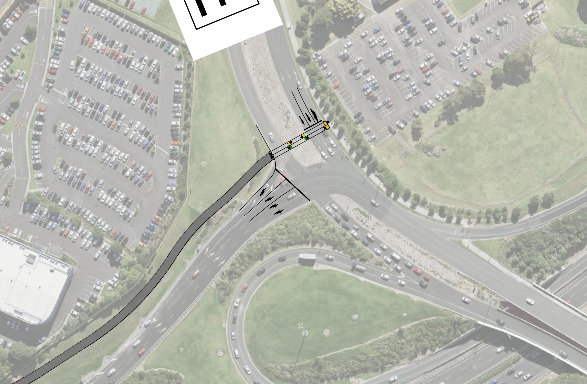
The biggest of these changes relates to where the path will cross the motorway. In the previous plans, the path would head down to Sulphur Beach and users would then use Sulphur Beach Rd, which would still be shared with cars accessing the area. It would have also required crossing Stafford Rd. Now the plan is to carry on alongside the motorway for long and then pass over the motorway on a bridge.
In addition to this there are also changes in how users would access Princes St as well as Onewa Rd. For I think the first time they’re also showing that path just north of Onewa Rd will be elevated for a portion.
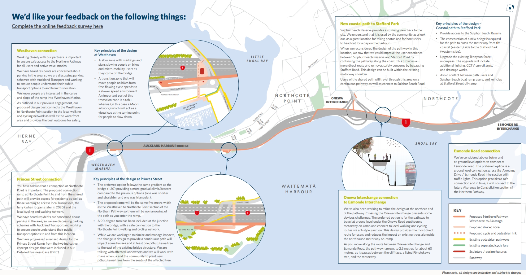
More detail is able to be gleaned from the route map. Working South to North.
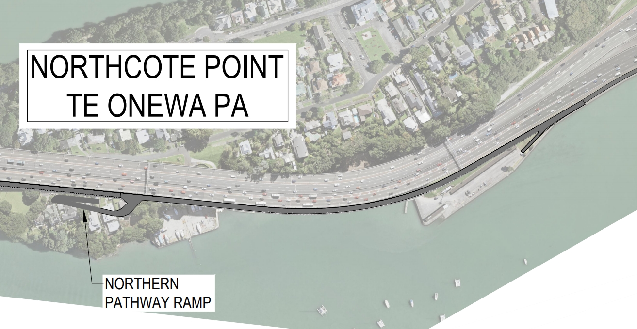
The Westhaven Connection looks to be unchanged from even the Skypath days with a ramp that doubles back on itself to get users back down to the level of Westhaven Dr.
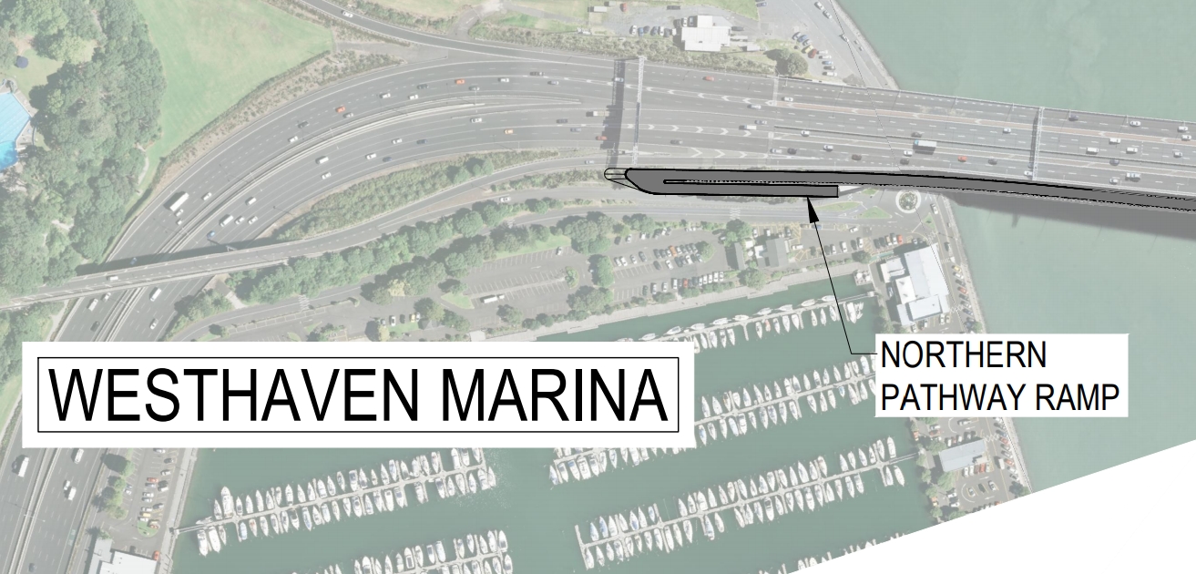
The first noticeable change is with the Princes St access which now shows a path that also doubles back on itself and would appear to require the removal of the remaining houses on the Eastern side of the bridge. On this they say in the brochure image above:
While we are working to minimise and manage impacts, the change in design to provide a continuous path will impact some houses and at least one pōhutukawa tree to the east of the existing bridge structure. We are talking with affected landowners and we will work with mana whenua and the community to plant new pōhutukawa trees from the seeds of the affected tree.
Losing houses is never a good thing but at the same time, if it’s going to happen, that land would make a great addition to Stokes Point Reserve. You can also see the path continuing on down to Sulphur Beach and then alongside the foreshore
It’s the next step that gets interesting and concerning. The path rises up to cross over the motorway on what I’m sure will be a stunning bridge. It’s not entirely clear if it stays elevated or if drops back down again but it then has to cross over the motorway northbound off-ramp before dropping down to get under the southbound off-ramp. It then does the reverse for the two on-ramps. As well as being a bit of a rollercoaster, this feels like it would encourage some cyclists to get up as much speed as possible heading down one ramp to make it easier to get up the one on the other side. But of course in the middle of all of this they’re also putting the junction to access Onewa Rd.
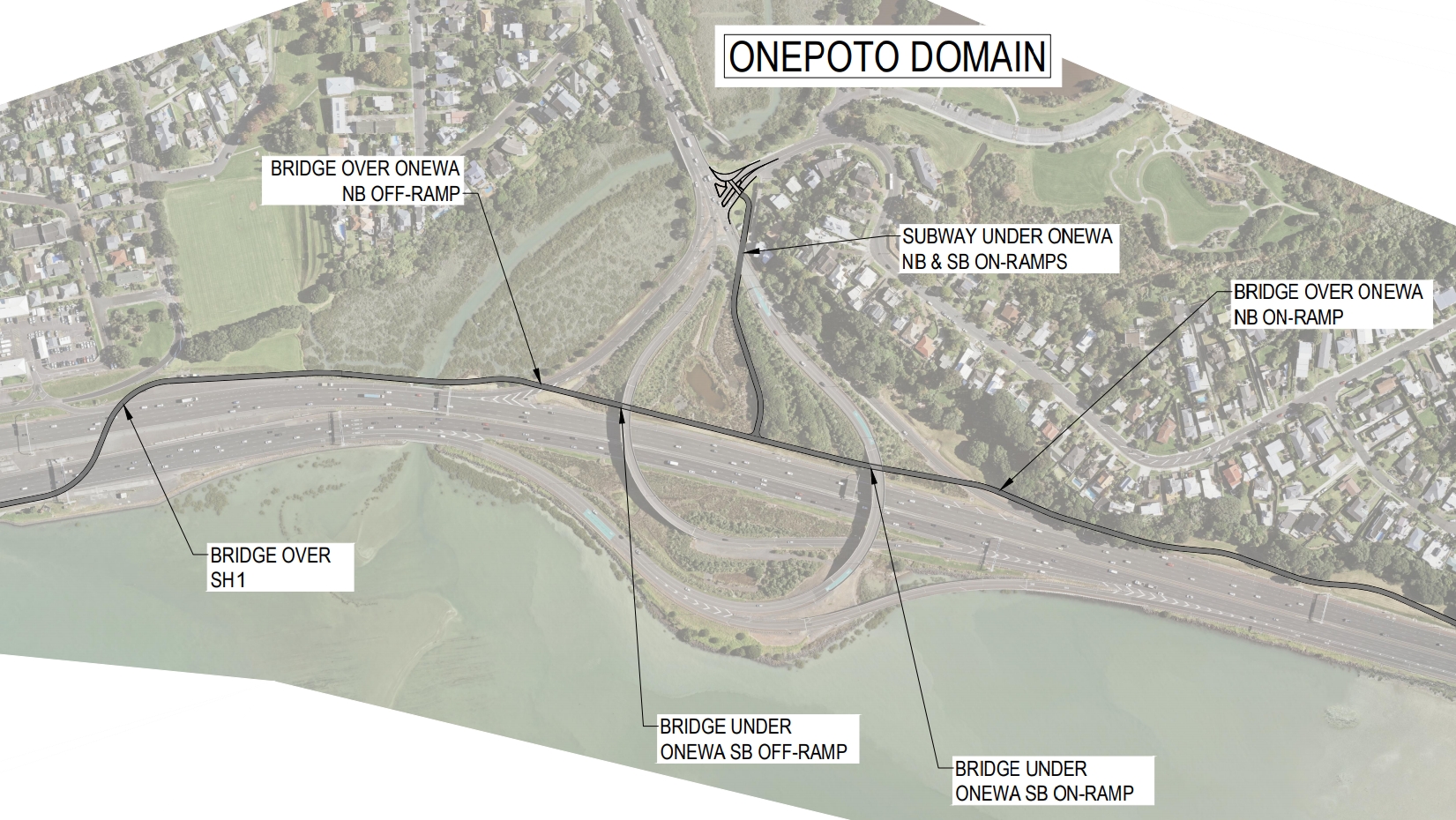
I wonder if they couldn’t go around the Onewa Interchange first before bridging over the motorway
Moving along, they say
As you move along the route between Onewa Interchange and Esmonde Road, the pathway narrows to 2.5 metres for about 60 metres, as it passes between the cliff face, a listed Pōhutukawa tree, and the motorway.

Given how quiet the motorways are right now, perhaps we should just take a lane off it?
Finally, at the northern end they’re working out how the path will cross Esmonde Dr. They say they’ve considered above and below ground options but prefer an at grade option with what appears like it could require waiting at two sets of lights – which I certainly hope is not the case. I also think there should be a footpath added on the southern side of Akoranga Dr up to The Warehouse Way.
Consultation is open from now till 12 April – although given the time frames involved, it does feel a bit like a box-ticking exercise.

 Processing...
The Onewa Rd interchange looks a mess. Given the time and money they’ve thrown at this surely they could have come up with something better? Maybe a slight detour that follows the Onewa on and off ramps and only has one road crossing – by the Sylvan Ave intersection??
Again given the money why are they even considering an at grade solution at Esmonde. Not another Lincoln Rd please!!
If as late as October they had a landing option at Northcote Point that didn’t mean taking out eight houses at probably $20Mill why have they changed it?
My first thought on reading this was it’d be nice if all the engineers involved could ride from their the CBD out to Westgate along the north western, notice how easy it was to go under the Rosebank and Te Atatu connections and how one stopped in their tracks at St Lukes and Lincoln. (with any luck Freddy the Fork is still taped to the pole at Lincoln rd).
Rather than have 3 bridges crossing the m.way and the two Onewa ramps why not have the bike path follow along past the bus lane then over the motorway once somewhere north of the Pohutakawa.
And one would like to think after the inganeers had ridden out along the North Western they could come up with something better for Esmonde. There is enough slope there to put a tunnel through.
Agree. People working on council projects and decision makers should all be daily commuters by the method of travel they’re working on. No exceptions.
I think that’s a little short sighted.
If for example Jarret Walker, who consulted on the New Network for buses didn’t use buses for commuting, should he have been excluded from providing input?
I think a more reasonable question is have the views and opinions of those who will be utilising this mode been sufficiently canvassed.
There are a number of great advocacy groups, such as Bike Auckland, who can be a voice, particularly in parts of the city, where there isn’t a large enough group to feel comfortable in submitting into processes like this.
No path along the reserve connecting to Exmouth St? That seems like a glaring omission.
Yes it does seem like an omission.
That’s the Heath Reserve which connects to the trail around Tuff Crater:
https://www.aucklandcouncil.govt.nz/parks-recreation/get-outdoors/aklpaths/Pages/path-detail.aspx?ItemId=44
Subway under Onewa NB off and NB on ramps, ala Rosebank Rd, and under the two off/on bridges at road level. Total, three subways. Done.
I had a look around on google maps this morning. That won’t work because the path would be below the high tide line. IMHO the best option is probably to continue along the eastern side of the motorway until it gets past the pinchpoint then swing across to the west. Then you would include a path back to Onewa Road. People coming down Onewa Road would then have good access to the north on the path and access to the south would be down Queen Street.
I think this option is significantly cheaper and gives better outcomes too.
You could always add another bridge at Stafford Park if you really wanted to connect there.
Sailor Boy, I agree your suggestion appears to have merit. It would remove the 2.5m pinch point from the “main trunk” of the route and maintain great views across to Bayswater. I believe there may be dotterels living in the area but this section of pathway could be bridged to protect the dotterels.
Why can’t the path drop down and cross under the Bridge/Motorway and feed onto Princes St. either at Stokes Point or a bit further along where the driveway down to the boatyard passes underneath?
The driveway drops steeply down to the waterfront and leaves heaps of headroom below the Bridge deck.
The boatyard was told by the council several months ago to remove all their boat cradles from the piece of land under the Bridge north of their driveway which they were using as storage space. It was assumed this was because preparatory work for the SkyPath would be taking place there.
This is what pisses me off about the RMA… a listed Pohutukawa tree is adversely affecting a major project!
I do say chop it down and replace it nearby with 2 or more pohutukawa instead! Better result for everyone including the environment.
I’d prefer it was moved, so that the ecosystem that evolves around mature trees can continue, if not slightly displaced.
There are some serious flaws to this design. I add my voice to the concerns about lights at Esmond. This is going to be a major crossing and pinch point for cyclists coming from Takapuna and Albany – it simply must be a bridge or underpass. Not just for flow, but for safety also.
The point made about Exmouth Road is also very good. When you think there is access at Princess Street, Sulphur Beach and Onewa, it seems too much is being spent on ramps for Northcote Point and not enough for Northcote.
Looking at the ramps individually:
Princes Street:
Looks like the plan is to remove 6 houses and the AHBA office (an old vila) and at least two trees. This will cost more than 20M. There is ample space there to not have to remove any homes and only take out the Govt owned AHBA office.
Sulphur Beach:
Does anyone believe that an on ramp is needed here? The Southern end of Northcote Point does not need to access points. NZTA need to decide if it is Sulphur beach or Princess Street.
Onepoto Domain:
Five bridges and a subway? I am not even sure as a cyclist I want to access the pathway from Onewa Road.
Exmouth Road:
There should be an access point here to serve Northcote central.
Esmond Road:
This needs to be a major point of entry/exit with ramps, bridges and tunnels. It is probably going to be the busiest intersection on the path.
I would have thought that the pathway should run on the seaward side with access points at Stafford park (serving Northcote Point and Onewa), Heath Reserve (Serving Northcote Central) and Esmond road (serving AUT, Warehouse, Takapuna and Milford). Doing it this way will save a huge amount of money on ramps and tunnels where they are not needed and put the infrastructure where it is.
I couldn’t agree more. I haven’t read the justification for running the “Seapath” (s/b “Motorwaypath”) on the landward side, but whatever it is, they’ve made a major error. Seaward side removes so many problematic crossings and then deposits people in the heart of Takapuna, which will be the prime destination. Thta’s near the beaches, shops, main bus routes, Devonport etc. Use overbridges to access points near Onewa and Akoranga.
I am opposed to the last-minute change of access ramp design which will now require compulsory taking & demolition of houses in Princes Street Northcote. There were earlier, less costly plans, which were perfectly viable, and to suddenly decide to destroy heritage homes is not acceptable.
Overall, constant changes in design details for this project have led it becoming such a moveable feast that I’m losing faith in the planning process.
Heritage home lol. They are worth nothing in heritage value
Doesn’t matter – we shouldn’t be destroying people’s homes, and if the path were on the correct (eastern) side of the motorway it might not be necessary.
Do you think they haven’t published a long section of the paths elevation because they haven’t done it or because it would highlight the major flaw in the loop-D-loop design!?
Adding to the chorus of people who suggest the path should run along the Eastern side of the Motorway. This was my immediate first thought upon seeing the proposed design.
From south to north:
Princess Street could be serviced by an elevator. I know these are unpopular, but it’s got to be so much cheaper than buying up and demolishing houses on the point. And this access really only serves the tip of Northcote Point.
Northcote road has a couple of options – an elevated cycle roundabouts, a la Eindhoven; or, as Sailorboy above mentions, simply have the Northcote Road access follow what is currently the Northern Onramp from Northcote road, then cross the motorway with a single bridge. Another crossing at Sulphur Beach would be a nice-to-have.
Staying on the Eastern side, that pinch point issue is removed.
Finally, getting to Esmonde Road, the existing Busway underpass is currently wide enough to accommodate cyclists and buses. It was constructed to be bi-directional, but is only in use for southbound buses.
In time it may be utilised for light rail, but that gives us 10+ years of good cycling before we re-design the interchange for what works at that time.
Crossing at grade at Esmonde road would be a disaster.
I believe it must be possible to mitigate negative environmental impacts in order to construct the cycleway on the Eastern side.
“On day two of the nationwide lockdown, residents of Princes St on Northcote Point said the New Zealand Transport Agency foisted a last-minute design change on them, which meant the Crown would now need to acquire their homes.”
https://www.stuff.co.nz/business/property/120758213/auckland-homes-to-be-demolished-to-make-way-for-harbour-bridge-cycle-path
How are they going to practice Social distance. 2 people walking side by side each way, going north and south = 3 meters
2 cyclists abreast going north and south = 4 to 5 meters.
Total 8 meters minimum
OH NO its only 5 meters wide some of the time.
ACC claims just like the scooters.
Why do they not up grade the under pass off Sulphur beach road and save the cost of 2 bridges. 2 less ups for the cyclists.