While Auckland’s bus network has radically improved over the past few years, many of the bits that go with it – things like wayfinding, announcements, reliability, shelter and transfer quality – have not changed much or have only had slight enhancements.
One of the things that feels particularly like a relic of a past age is the way AT communicate diversions. A good example of this was the recent New Year’s Eve street closures in the central city. If you were planning on taking a bus down to the celebrations, this is what you got:

There are several pages of this, and a list of closed bus stops at the end. I’m not totally sure why the adjusted routes are presented as turn-by-turn descriptions from the point of view of a bus – but I’m guessing that these are instructions given to drivers which have been copy pasted into the website directly, instead of creating something useful for customers. And unfortunately, this is the usual way bus diversions are communicated – it’s not just a New Year’s Eve thing.
The most obvious alternative would be to present a map of the adjusted routes – perhaps a simplified version of the normal city centre route map – so you could see at a glance where the buses will go without having to mentally parse a huge table and turn it into a map in your head.

An added benefit of this is that it would show all the routes at once, so you could see alternate ways to get anywhere, with transfers, instead of just having to take “your bus”. At a deeper level, AT’s reluctance to present this sort of information as a map perhaps indicates that they’re still struggling with the concept that the new network is in fact a network, and not just a disjointed collection of routes into the city centre that people use for commuting.
AT did eventually publish a map of the street closures. But while it was useful for seeing where you could hang out, or motorists to see where they wouldn’t be able to drive, it still required you to cross reference the wall of text to work out how your bus might be affected. Provided you were lucky enough to be able to read the stop numbers through the tiny font.
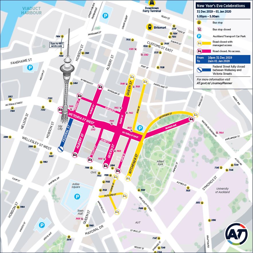
It’s unlikely that anyone at AT actually thinks that presenting information in a way that might be most appropriate for a 1960s robot is actually good for customers – it’s probably because it’s the way it’s always been done, and it’s easy. But if we can get it right for motorists, going a bit further to draw some lines on a map for bus users as well doesn’t seem like it would be that hard.

 Processing...
Thanks for the post. The other issue I encountered is the bus and train cancellation. For example, my parents were trying to catch a bus 75 from Remuera to Newmarket in one Saturday during the Christmas. Their bus stop has no electronic signboard, thus they were unaware that multiple #75 buses were cancelled on that day (it became one every 4 buses). This was very disappointing, and they went home and drove in frustration.
Another day (it was a Friday afternoon) I arrived at Britomart and found that a number of trains were cancelled due to track fault near Britomart. I would have thought AT will push such significant disruption notice disruption through the AT app, rather than rely on individual users check Britomart status.
Hopefully they will get better in communicating service outages as it really give a negative impression to non-regular PT users.
I had a similarly joyous experience. Journey planned on the AT website at home and it recommended the 751 bus to Newmarket. Went to the stop and pulled out my phone to track my bus on the mobile app, only to discover the bus was cancelled.
Called to check and was told cancellations were posted someplace on the website. Suggested they should have been visible on the Journey Planning page. Let the other would-be passenger standing at the stop know. Went home and took my car instead.
Don’t remember seeing anything at the stop notifying people that their bus might not come either.
Yes those diversion instructions are hideously non user friendly to most people.
There are many examples of poor information for casual user.
For example AT still doesn’t provide a map that shows all the minor bus stops. How do we expect casual user to know?
Not only that, the online ones still have mistakes, 1.5 years later from the new network.
Glad it’s not just me. I gave up trying to figure it out.
Mistaking the relationship with the operator not the user as the key (or only) one?
Staring all day at spreadsheets not getting out and experiencing actual service?
No one owning whole-of-network and user relationship as final check over details?
Lack of enough and empowered deep knowledge service specialists?
Focus on bus vehicle journey rather than user journey?
No one in charge of bus stop user experience?
And obviously not one single person at AT has ever experienced the Link Vic Park engine off driver change clown show or that would have been fixed years ago…
And of course:
Still using models that over-prioritise private vehicle road use (no question mark for this one; this is certainly true, why else do buslanes still disappear at intersections so drivers can have dedicated lanes for every single turning option and entire light phases for minor movements).
…
Yes.
Btw, the “Link Vic Park engine off driver change clown show” has migrated up to College Hill. Yesterday we had an 11-minute wait there while both the inner and outer links waited for new drivers. At one stage there were four buses clustered, one double parked with its hazards flashing, and the 20 struggled to get past them all.
When the drivers arrived I heard one say, “It takes ages to get out of the depot,” which might just be because Wynyard Quarter – intended to be a walkable precinct – has become clogged with vehicles due to poor planning and too many car parks.
Heidi, to be fair the target for car mode share for Wynyard Qtr is 30% by 2030. I suspect AT simply don’t care what it is now because it isn’t 2030.
I am surprised that there is a problem for buses getting out of Halsey St because there are three lanes and very good light phasing. This phasing is to the detriment of buses on the RTN route going from the city. These buses can be delayed for four or five phases at the lights.
Strangely AT have engaged a consultant to look at the problem. Is this too big for any traffic engineers that AT have employed? Are all the current engineers busy designing plans for the placement of cones around the city? Are AT too timid to make a decision that may compromise the movement of cars?
Issues such as mode share in the Wynyard Qtr are reflective of the fact that despite all the rhetoric AT views Auckland as a car centric city and lip service is paid to other mode shares.
“not one single person at AT has ever experienced the Link Vic Park engine off driver change clown show or that would have been fixed years ”
INCORRECT: Try doing some research before posting.. 1. See the Cross Town Bus Consultation project that is on the AT Web Site, here: https://at.govt.nz/projects-roadworks/central-crosstown-bus-changes/, 2. Driver changes are now a requirement of the Employment Relations Act. See: http://www.legislation.govt.nz/act/public/2000/0024/latest/DLM58317.html
I think there is a much bigger problem on display; that catching a bus from the central city is almost impossible if you don’t know where from. Almost every route has its own departure point(s). A dominion Road bus is different to a Sandringham Road bus which is different to a Mt Eden Road bus, and somehow you just need to know all this.
Couldn’t we have a central bus station? We seem to have money to build these all over Auckland but for some reason not in the city!
And where are the buses actually going in the CBD? If you catch a bus heading there you could end up in Queen St, mayoral drive or even Albert St. Why don’t buses going into the CBD display their final destination instead of something vague and confusing like Central Auckland!!
Sorry meant Lower Hobson st not Albert. Happened the other day with a 13… something much to several passengers’ horror who pleaded unsuccessfully to get off.
“Why don’t buses going into the CBD display their final destination”
They already do.
Any CBD station would be an order of magnitude bigger than any of the suburban stations. I can’t think of any land that is sufficiently central that would be big enough for the Manukau station let alone one needed to handle all the buses in the CBD.
There’s plenty of land that could accommodate a bus station on the ground floor when redeveloped into a higher value use. For example the Downtown Carpark, Britomart Carpark etc.
The Downtown carpark’s footprint is only marginally bigger than the Manukau bus station yet a CBD station would have to handle significantly more buses.
Also I’m not sure that the surrounding streets would handle the bus traffic, especially if there is LR on Customs St at some point.
I can’t see the logic in what would be a significant investment to have all the buses arriving two blocks away from Britomart. It would take NEX buses further from Britomart than they already will be on Albert St.
Maybe in your alternate universe, but there’s no way a dirty, noisy, smelly bus station would be acceptable to high value redevelopment on very expensive land.
Dirty, smelly, noisy ya? https://architecturenow.co.nz/articles/christchurch-bus-interchange/
Even if we had 3 or 4 city stations that would be a big improvement on just trying to find a random bus stop somewhere.
I agree there should be 3 – 4 major stops that are well signposted, have good shelter and facilities and every bus goes through at least one.
However, I think it is more efficient for these stops to be in-line with the street for easy through running of services.
Where would this central bus station be located?
Somewhere. Underground maybe? Maybe have multiple stations? Surely there has to be a better way than just random bus stops scattered around!
In my opinion, a better use of the huge amount of money an underground bus station would cost, is reducing the number of buses by investing in light rail.
” that catching a bus from the central city is almost impossible if you don’t know where from.”
SOULTION: Use the AT Journey planner app.
“Couldn’t we have a central bus station?’
Where? How about Henderson? Henderson is very central to the West.
AT isn’t alone in being a little wayward with bus diversion notices. When Queen Street between the town hall and Mayoral Drive was closed for repaving over Christmas, it involved closing a Sky Bus stop for its airport service. I presume this is used by tourists with little knowledge of Auckland and little or no knowledge of the English language, but the only notice they got was a little notice on the lamp post stating the bus stop was now in Mayoral Drive opposite Subway (I think) – no directions, or any other mention about how to get there, not even a person on the ground to point them in the right direction. The result was tourists running round in circles with their suitcases on wheels, getting into panic mode about where this new bus stop was on a road they had never heard of before.
‘but the only notice they got was a little notice on the lamp post stating the bus stop was now in Mayoral Drive’
How do you know this? Perhaps everyone who booked a SkyBus that week was also advised using the following channels: 1. on the SkyBus web site. 2. By email. 3. By text, 4. by the ticket agent, 5. by each SkyBus driver, 6. via Twitter etc