Here’s our weekly collection of smaller pieces.
Road Funding
The discussion about how much money we spend on roads has been high on the agenda this week, particularly in the wake of the government’s announcement they’ll be investing $6.8 billion extra in transport over the coming years. But that’s not been the only topic of discussion and on Monday we had the Road Transport Forum absurdly blaming an imaginary lack of road funding on extreme weather washing out hillsides.
The group representing the road transport industry blames a lack of investment in roading for the degree of damage caused by storms.
Weather over the weekend caused mayhem in the South Island, cutting off road access and stranding hundreds of people after bridges washed out and hillsides slipped on to highways.
NZ Road Transport Forum chief executive Nick Leggett said vital supply lines were cut, including those needed to get food and supplies in to stricken areas, and produce out to markets and retailers.
He said investment in highways had decreased in the last couple of years, when it was needed to counter the effects of increasingly damaging storms.
“If you talk to road users – people who drive cars but also truck drivers, they say the maintenance standards are slipping, and actually, if you have well-designed, well-built roads what you find is that they don’t fail as much in extreme weather.”
As mentioned yesterday, we’re spending billions annually on new roads and also on maintaining the existing ones. Despite the rhetoric from some, the overall quantum of funding remains high. But I would be surprised if any of the sites that have experienced slips or flooding recently were on priority lists to do something about.
But if the RTF and politicians want something to blame for there being not enough funding for rods, then a prime candidate would be other roads. For example these two excerpts come from the NZTA’s August board minutes and show that over just two projects there has been hundreds of millions in budget blowouts.
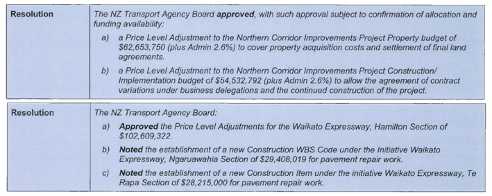
I suspect these won’t have been the only projects this has happened to.
Henderson Valley Rd
Henderson is one of the areas Panuku Development Auckland are developing and a part of that is improving the northern end of Henderson Valley Rd. Their proposal looks great and includes:
- the under-grounding of power-lines
- over 20 new street trees
- new footpaths
- pedestrian crossings
- protected cycle paths

It would be great if more streets looked like this.
Consultation closes 20 December.
Drury Consultation
Supporting Growth, the alliance planning the transport infrastructure out on the fringes, have released another consultation for Drury. This time they are consulting on the draft preferred option, which follows the indicative network that was released
One good thing I noticed is the station sausages have gotten smaller and unlike earlier consultations, look to be in about the right places.
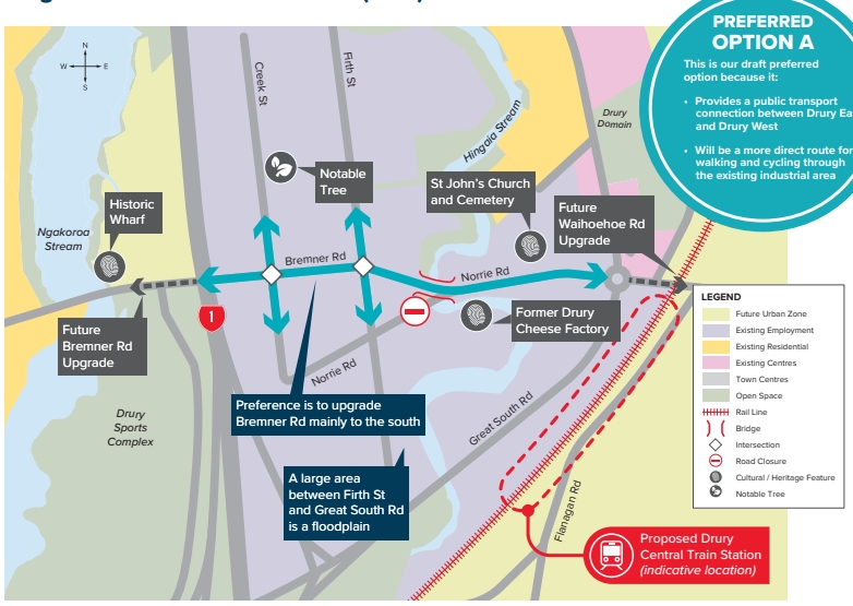 Consultation closes 24 January
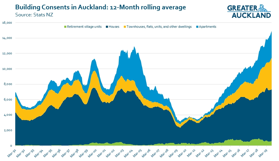
Building Consents
The October number for building consents came out recently and they continue to show strong growth with the 12-month rolling total increasing to 14,900, another all-time record. Assuming the current trend continues then once the November stats we should have crossed the 15,000 milestone. That’s a far cry from where things were a decade ago.
As you can see below, there has been a strong uptick in consents and importantly, now only 45% were for single houses, that’s a record in its own right with it being the lowest percentage we’ve seen since records began.
Sydney Light Rail
Eyes will be on Sydney this weekend with the first branch of their new light rail line opening to the public tomorrow. The line runs between Circular Quay and Randwick with another branch to Kingsford opening in March next year.

One of the key features of the route is a transit mall on George St which would be similar to what was planned for Queen St before the Superfund got involved.

The port will move – eventually
The government’s Cabinet discussed the report on moving the port and have declared that its current location is not viable in the long term. But there’s a long way to go before the port is moved and yesterday it was announced that more work will first be completed
“To maintain momentum on this work, Ministers have instructed the Ministry of Transport to undertake further work on funding and financing options, governance and commercial considerations, land use planning, legislative and regulatory considerations as well as some additional transport and logistics analysis.
“I expect this analysis to consider environmental effects, including on New Zealand’s overall greenhouse gas emissions, and consideration of Government infrastructure investments in roads and rail, for example, building a rail spur to Marsden Point.
“Ministers have also requested that officials work with the newly-established Infrastructure Commission to ensure we’re taking a holistic view of our logistics network and the major infrastructure needs of New Zealand.
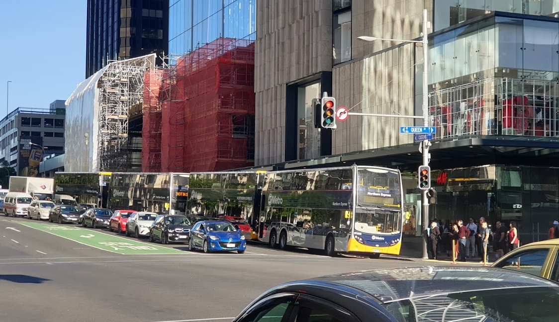
The temporary bus stops are better
Lower Albert St is currently closed till 9-February while the road is rebuilt as part of the Downtown works. That has required the NX1 and western North Shore buses to move. For the NX1 they’ve moved the bus stops to Customs St with buses dropping off outside H&M while departing buses leave from outside the Dilworth building (between Fort Lane and Queen St).
As someone who transfers between the NX1 and trains on a daily basis I have to say that these temporary bus stops are far more convenient than the ones on Lower Albert St. So much so that I think AT should consider making them permanent – although they would also need additional bus priority to ensure they remained reliable.

 Processing...
I am guessing you mean the new location of the NX bus stops are better as opposed to the constant shambles of temporary stops. Of that I could not agree more, Albert St was hopeless for buses.
However on that subject, they have now moved Birkenhead buses almost out of the CBD to Hobson St, 6th move in a couple of years and yes, AT’s version of “Where’s Wally” is getting pretty tiresome. It’s better than the warzone that was Quay St but all of it speaks volumes about how low-grade PT and its users are considered when the main terminating/departing stop is wherever a dart lands on a map on any given month, this time a decent hike away from anywhere. Where next, Beaumont St perhaps?
Perhaps this is AT’s ironic reverse logic way of “luring motorists out of their cars” because doing this sort of thing all of the time kinda makes the sheer convenience of cars all the more enticing!
https://www.stuff.co.nz/auckland/118107176/auckland-and-government-agree-a-plan-to-get-motorists-out-of-cars
I couldn’t agree more. It’s bluntly obvious, even in the header photo – who gets the priority here. AT really needs to look at its priorities. Forever trying to ‘maintain the flow’ is not going to “lure anyone out of the car”. Space in the city centre is at premium and dedicating so much to single-occupant cars is plain insanity.
I would agree I couldn’t find the bus stop for the 975b or any other Glenfield bound bus.
Lucky I had my e scooter with me I ended up catching a nex bus from the last bus stop on fanshawe, and ride the scooter from smales farm station to Glenfield.
It’s also hard to find as there are no shelters or seats and looks like any other street.
But you will get AT’s best wishes with Auckland’s rainy climate, waiting for buses and or getting to them!
Waspman
Here was the clue to set your expectations low, “The mode-shift work does not introduce any radical ideas.”
A South African colleague of mine refers to it as the nafai (nah-fee) approach – no aptitude, …. all initiative.
It never ceases to amaze me that AT collectively see the end user of public transport as a nothing. It’s almost like “this stop will do for these losers” type of attitude. There is absolutely no forethought by them to making bus use experience as good as it possibly can be, because largely, buses are all we have. Rather its as amateur as it can get.
They fob off minimum standards of buses and delivery of services to the contractors but when it comes to infrastructure like a central city bus hub that they are responsible for all care goes out the window. AT seem to think the nomadic bus terminus, anywhere, anytime with zero amenities is acceptable. And yet Goff, (and not surprisingly Twyford), think this unacceptable situation will draw motorists from their cars. What idiots!
As a daily commuter using train and NX1, I would think the Lower Albert Street is not good in its current state due to simultaneous construction of Commercial Bay and Quay Street. Wouldn’t it be possible in future, the passengers can take a short cut via Commercial Bay Shopping Mall ground floor, which is a direct route.
I don’t feel the current temporary bus stop next to the Commercial Bay construction site is safe (for Britomart stop). It’s a tight spot with lots of foot traffic. Something needs to be done even if it is a temporary for 2 months.
It’s exactly what they are planning. A lane way through the building though perhaps a bit narrow.
To add insult to injury, the route planner still thinks it stops on Albert Street.
I’m intrigued by the picture of the Henderson Valley concept and I’d love to know more. It appears to be modern, with cycle-lanes, grassy berms, even a thin strip of green right down the median strip, and other modern signs such as children on scooters and lush Henderson greenery everywhere. So far, so good.
However it also has a car, looking suspiciously like a Ford Anglia 105e (last made in 1968), as one of the few signs of automotive life in this otherwise bucolic scene of very urban / suburban life. There are at least 17 people in the picture with five on bicycles and two on scooters, but only one truck, and only one and two half cars. I’ve heard that Henderson is out West, and possibly situated in a slight time warp, but even the notorious West family drive more modern cars than an Anglia, and I believe that in areas containing four-storey apartment buildings, there are likely to be more cars (and possibly more likely Holdens than Fords) on the streets. What exactly are we meant to be reading from this illustration? Is it significant that the MP for Henderson is none other than the Minister for Transport, Mr Phil Twyford? Is it in any way significant that there are only white people in the picture, seemingly most likely middle class due to their attire, and everybody seems to be having a great time walking arm in arm with their family on the streets? Is it just an illustration of a road crossing possibility, or is it a more sinister revisionist view of history, or should I expect to see Marty McFly in there as well? It’s all a mystery to me.
Talking of green Henderson, that greenery covered wall at the station opposite westbound platform is an absolute delight. I fear it will be destroyed when the CRL station upgrades get underway and that would be a shame.
Not sure if it has already been posted here, but KiwiRail have released an Expression of Interest for Civil and Structural Design of W2QP (Wiri to Quay Park). This project is primarily the third main from Westfield to Wiri.
Hopefully this is a sign that progress is being made on the project.
The EOI includes quite a lot of information including track layouts. You must be registered with GETS in order to access the files:
https://www.gets.govt.nz/KRG/ExternalTenderDetails.htm?id=22012403
On a more serious note, the Port. I’ve said it before and I’m going to say it again: the Port does not need to be thought of as ONE port, in ONE place. Clearly it has outgrown its current location, and yet it has multiple functions. It has vast number of cars coming in, and vast numbers of containers coming both in and out, as well as a certain amount of other cargo – in bulk – possibly logs, possibly cement, etc.
Can anyone say why it cannot be broken up into logical different functions? There is no reason why all the containers (clearly not time-dependent cargo) need to go right in and out of Auckland at the footstep of Parnell – they could easily be shipped elsewhere – more usefully for the rest of New Zealand, probably Tauranga is a more useful destination – North Port much less so.
The cars are different – mostly destined for Aucklanders in that car-oriented city – and surely ultimately destined for car yards on Great South Road or Barry’s Point Road – there is little point in the being paraded at Parnell in that vast, ugly, and soon to be completed (or demolished?) car parking building being built by the Port.
Bulk cargos such as Cement are already shipped to Manukau – they are different cargos, on different ships, and a shining example of how the different Port locations could work together for a better outcome for New Zealand. Can’t we all be better thinkers than just saying “Move it all” to X or to Y?
Most of the containers are destined for Auckland as well.
Jezza, yes, to an extent. But Auckland is not a really large manufacturer – there are few manufactured products going out of NZ, it is more likely to be primary products like butter, sheep meat, wine, wool, etc, none of which are primary products of central Auckland as a city. Shipping outward makes more sense from a smaller, more provincial port – logs out from NorthPort and milk products out from Waikato to Tauranga Port.
Instead, the container traffic coming inwards to Auckland is going to be mainly domestic products from China – household goods destined for the Warehouse, clothing for Westfield, floor tiles for the Tile Warehouse, lawnmowers and drones in boxes for Christmas trees everywhere – yes, destined for the majority population base, which is not north of Auckland, but in fact if aimed at a port situated south of Auckland, encompassing Hamilton, encompassing Tauranga, Rotorua, etc – there is only really one logical location for a port for the future, and that is simply not central Auckland.
Sounds a lot like it’s not 150km to the north of Auckland either.
Guy – what you are describing already happens. Export products from the central North Island generally go out through Tauranga and to a lesser extent Napier. Auckland is primarily an import port.
Tauranga has been very successful with metroport because the export nature of the port means there is a lot of import capacity on the ships. The market has already sorted out what you are describing.
I agree with you that the logical option for a port is a little bit south of Auckland but not too far ie. the Firth of Thames, but there are some significant cost and environmental hurdles to this option.
My point was that the majority of containers arriving in Auckland are destined for Auckland, it’s a myth that they are being transported through the city to locations further down the North Island.
You are correct, there is not a lot of Export volume from POA, it mostly goes out of POT, but there is a massive amount of Imports, and nearly all of it stays in the Auckland region. Also, a large amount of the import volumes at POT are also trained to Auckland.
You can see stats per port at https://www.transport.govt.nz/mot-resources/freight-resources/figs/trade/tables/
It is not true to say containerised freight is not time sensitive, maybe not as much as air freight, but every extra day in transit is adding at least $100 in cost for things like storage, handling and extra labour. It cost much more if it is refrigerated freight.
Containers from Tauranga destined for Auckland already add 2-3 days transit from Vessel discharge to customer delivery when compared to freight unloaded in Auckland. It would be similar delays if containers were in Northland. Without a major upgrade to the North Auckland Rail, this would be 5 days plus with current volumes.
(I work in Container logistics in Auckland)
Bold – what causes the 2- 3 day delay with containers to Metroport. I would have thought with the number of trains running each day this shouldn’t be much more than a day.
Bold, That is interesting.
The next question that needs to be answered is; Would container transit time from Northport to freight depots in Auckland be any better then from Tauraranga?
Surely the solutions for both are the same, in enhancing the rail connectivity but the challenges with both routes need to be assessed against each other.
A guess is that these challenges are less initially from Tauranga but ultimately duplicating the Kaimai tunnel needs to be considered.
Thanks Jezza for the corrections – and huge thanks to Bold, for some real life facts. I stand corrected. But both of you therefore really confirm my suspicions – that aiming the proposed “new” port north of Auckland would be a serious mistake in the case of containers. If, as Bold says, most of the containerised imports are aimed at Auckland, and seeing as we don’t have a decent rail link from north of Auckland, but we already have an excellent main trunk line leading south from Auckland, and lots of land that containers could be stored on south of Auckland (south of the Bombays maybe?) then surely, the best place for the Port must be Tauranga. There’s just no contest.
I do feel sorry for the western line users here if the port (fully or even partially) moves north. I’m not sure how slow cargo trains can be slotted in with the post CRL frequencies here.
Agree, each cargo type needs to be analysed and both its initial, and then final spread of their contents destinations ascertained.
If it is found that the primary destination of import containers is South Auckland, and from there 50 of the contents are distributed within Auckland and the vast bulk of the remainder distributed south, then it makes little sense to land these containers in Northport and transport them through nearly all of Auckland. Long term obviously Auckland cannot land the bulk of import containers for all of New Zealand. It is also obvious that long term these cargoes must be landed south of the Auckland city centre either at a new port or a combination of expanding and reallocating capacity at Tauranga and other existing ports.
Similar exercises must be made for each cargo type and determine appropriate options.
The cement doesn’t go to Manukau anymore. As you drive down Quay street you will see cement silos. The square ones are Golden Bay the round one is Holcim.
Golden Bay plant at Portland is close to the rail line near Whangarei, Holcim imports its product.
However you do have a point. If a suitable location could be found for the cars and the break bulk like the cement and the scrap steel and gypsum for the wallboards then containers could be handled at Marsden Point and Tauranga. However nobody has being able to come up with one yet. Maybe the Firth Of Thames but it would require dredging and some sort of a causeway to get out to deep water. One thing in its favour is it wouldn’t necessarily require a rail connection as these materials are usually trucked. Although a Port at the Mouth of the Waihou river at Thames is fun to consider. We could reopen the Thames branch.
Off course instead of driving down Quay street you should be walking, scootering or cycling you can even see them from a bus and maybe from a train.
Cement shipping into Onehunga stopped over two years ago and the ship (Milburn Carrier) was sold overseas. Cement now comes in bulk to Auckland and is stored in three silos before batching into road trailers. Some cement bagging is still done at Onehunga.
I’ve been through the papers they released for the port move last week and I’m disappointed that they declared that the existing port is not viable. It seems like they’ve pre-determined much of the question the follow-up study is going to address.
The Treasury advice noted that the BCR for the move might only be 0.3 (whereas the working group had been saying it was 2). In coming up with that assessment the Treasury didn’t seem to put much emphasis on the land value potentially being lower than claimed by the working group, and it is not clear if they have identified that costs at the Port of Tauranga claimed as part of the bill for keeping the existing port open would still be needed if the Northport move went ahead. So, the economics could be even worse.
And the environmental and social impacts of the move may be worse than staying.
The Northport move apparently requires dredging on the door step of a marine reserve in an area used by orca, whales and dolphins. Whereas I haven’t heard anyone say the Rangitoto Channel, where dredging is required if they want to accommodate bigger ships in Auckland, has particularly high environmental values.
And though the working group are disputing it, it does seem the port move would have to push up consumer prices in Auckland. The question still is how much.
“a shining example of how the different Port locations could work together for a better outcome for New Zealand.”
Didn’t cement just recently move from Manukau to Auckland?
https://www.nbr.co.nz/article/holcim-progresses-cement-import-plan-signals-exit-lime-business-bd-158225
Is now the time to resurrect the campaign for the Taupo Line branch? Seems to tick all the PGF and tourism boxes. I’d use the absolute hell out of it. Run it right into the city centre and offer services daily. Bonus points for being able to get from Taupo to National Park if at all possible.
https://en.wikipedia.org/wiki/Taupo_railway_proposals
BW
Yes probably rail to Taupo should be examined. In a carbon zero economy in 2050, is travel by car by the masses still going to be possible. I know that the powerful automobile industry would like to think so, but many countries in Europe are turning/have turned to rail for intercity transport. Sure the scale of travel is many times greater in Europe, but the smaller population in NZ makes the construction of roads expensive when considered against the taxation base. It is also becoming increasingly inequitable for people who have chosen not to own cars to pay significant amounts for building or maintaining roads.
Just popped into Papakura Museum today (opposite Papakura Library, convenient access to both the train station and several busses) and noticed the current special exhibit is about the local train stations. Of course, this is newly topical what with the bit about Drury’s potential new train stations mentioned in today’s post. I encourage everyone to come have a look, especially the GA volunteers. Entry is free.
(There are also aerial photos of Papakura showing the area through “the ages” if you’re interested in urban change.)
Slightly off key , I got this from AT today ;-
Waiheke bus service changes from Monday
From Monday 16 December, a number of service changes to the Waiheke bus network will be launched.
The Waiheke Bus Company has advised us that despite big efforts and a recruitment campaign, the driver shortage is affecting its ability to provide the full schedule of services on Waiheke.
For these reasons, services between Onetangi and Matiatia will be reduced to half-hourly, by temporarily removing route 50B.
Several options were investigated before making this decision. This option has been selected because it means that no area will lose a bus service completely, while all passengers will still be able to connect with the ferry.
Routes 502, 503 and 504 will continue to operate as normal.
Service changes to Jellicoe Parade / Wellington Rd:
50A Buses to Matiatia from Jellicoe Parade / Wellington Rd: Every second 50A service will divert around Jellicoe Parade / Wellington Rd on the way to Matiatia.
50A Buses from Matiatia to Jellicoe Parade / Wellington Rd: Every second 50A service from Matiatia will only divert around Jellicoe Parade / Wellington Rd if the driver is requested by a passenger on board the bus.
New temporary service for Ostend Rd:
50A Buses to Matiatia from Ostend Rd / Wharf Rd: Every second 50A service will divert around Ostend Rd / Wharf Rd on the way to Matiatia.
50A Buses from Matiatia to Ostend Rd / Wharf Rd: Every second 50A service from Matiatia will only divert down Ostend Rd / Wharf Rd if the driver is requested by a passenger on board the bus.
As these are temporary changes only, timetables on display at bus stops will not be changed.
The Waiheke Bus Company will be restoring full timetabled services once they have sufficient drivers. We apologise that the Journey Planner, AT Mobile app, and printed timetables cannot be updated in time to reflect these changes. To find more information, visit our website.
There was a petion from the locals concerning the Ostend/Wharf rd route that had been in operation for around 70 odd years which under AT’s wisdom was removed and now has been reinstated . This route was used by a lot of aged that lived in the area .
And finally they have listened to the people who where affected by the removal .
And at long last some one has stood up and said there are a shortage of drivers . And over the last few summers Waiheke were bringing drivers over from H+E to help with their services . Wiether this will happen this year who knows .
And you have these to strange ideas from them 1 ;-
“50A Buses from Matiatia to Jellicoe Parade / Wellington Rd: Every second 50A service from Matiatia will only divert around Jellicoe Parade / Wellington Rd if the driver is requested by a passenger on board the bus.”
What happens if a passenger wants to go to the Supermarket ? . Do they 1st go to the ferry then return to Ostend to do their shopping . And that could take upwards of 1-1/2 hours
2;-
“50A Buses from Matiatia to Ostend Rd / Wharf Rd: Every second 50A service from Matiatia will only divert down Ostend Rd / Wharf Rd if the driver is requested by a passenger on board the bus.”
And do they do the same here ? Or if they want to go to Onetangi , What is the matter with AT’s logic or has it been left on the pillow when they wake up , it’s the most idiotic idea or do the drivers have x-ray vision to see who is waiting at the various stop along those areas.
That Henderson plan does look nice having had a quick look at the plans earlier. I remember the rush to not miss a train on a Sunday a couple of years ago after cycling the streams pathway and what a horrible experience with my wife & child to cross Henderson valley Rd and find the station. They got tooted after getting stranded half way across the road or something when lights let the cars go like a drag strip.
Regarding the picture of Henderson Valley Road, could someone explain for me how that intersection is supposed to work?
If a car travelling the same way the truck is turns into the side street in the foreground, it has to cross the cycle lane and the pedestrian crossing. This raises some questions:
1) How does the driver know the cycle lane is clear, when it largely comes from behind, with extremely poor sightlines? Or will cyclists be required to give way or stop?
2) Where does a turning vehicle stop for either the cycle lane or the pedestrian crossing, when there clearly isn’t enough space for a vehicle to do so, without blocking Henderson Valley Road?
It seems to be very poor design that has thrown safety out the window.
That building consents graph just goes to show how poorly (putting it nicely) the previous National government was. That huge dip in consents is roughly about 20,000 homes (which is a good chunk of the shortfall).
They failed to support the building industry and builders during the GFC and many of them simply left for Australia etc. If there had been that support we’d not only have those extra 20k homes in Auckland, but our current rate would also be higher due to those builders etc still being in the country. Construction costs would also be lower.
This was not one of Matt’s stories of the week, but none the less a story of the week.
https://www.stuff.co.nz/national/118158607/new-years-eve-aucklands-biggestever-street-closures-for-revellers
“Auckland Transport told Stuff 26 services contracted from NZ Bus didn’t happen, while another 32 after-midnight services were late departing.”
While AT might blame NZ Bus, from the perspective of someone who was there, clearly it was AT who was the problem. But where to start? That all (yes all, not some) of the buslane on Halsey St was occupied by parked cars ensured that Halsey St was badly congested and the bus we were on (the 82) took an eternity passing down Wellesley St and Halsey St. Little wonder buses didn’t run to timetable and hardly NZ Bus’ fault.
City congestion is exacerbated because AT’s parking buildings are so damned cheap – $2 an hour for some. Until AT ditches the concept that they have to provide “cheap parking”, and I know that they profess not to operate this way, but the evidence is that clearly they do, then this will contribute to people not using public transport.
I am not going to talk about the failure of AT to close roads, but it was evident from as early as 10pm that was a real problem.
Let’s hope that the changes AT have made this year ensure a better event.
I realise this isn’t entirely on point (ok, it’s not at all), but it’s part of a response to “getting people out of their cars/mode shift”. Reliability.
Does anyone know what’s happening with Birkenhead Buses this morning? (Saturday). I checked my journey planner to find several random cancellations of buses from Beach Haven to city/TPuna? No info on AT or anywhere else. This kind of screws up my work day.
Here’s some videos of Sydney’s Light Rail opening day. It replaces more than 200 buses through the CBD for each hour of the peak. It was going a bit slower on opening , being cautious and due to the free day packed to the rafters, teething problems etc:
Bit of a negative slanted news article on it: https://www.youtube.com/watch?v=BbuGgdTGWpM
A longer video blog of the day: https://youtu.be/zAHG_ohVBoU
Also interestingly a section of London’s CrossRail is opening today from Reading and Paddington. I think a lot of the other sections have been delayed still. Here is an early soft opening run on the new trains from the other day winter morning on a 7 car length set (they will be 9 when all up and running I think I gathered). Great purple branding. Warning he says the word “purple” many times in this video.
https://www.youtube.com/watch?v=SXV95PR7pEc
Note we are not the only country that has things delayed, both of these projects have seen delays.
And if you think our AT HOP system is rubbish, checkout the intricacies of the London system where “On the London Rail and Tube Map, Brookmans Park has appeared with a ‘Contactless’ symbol next to it, denoting it can be used for Contactless PAYG travel, but NOT Oyster cards!”
Also their signage, maps and such were all a little out of kilter related to that:
https://www.youtube.com/watch?v=m0xDbHj4K_E