The council are currently consulting on a refresh to the City Centre Masterplan (CCMP). One of the key goals of the CCMP is to make the city centre more people friendly and that means needing to dedicate more space for pedestrians, bikes, scooters and public transport and less for cars. Perhaps one of the flaws of the CCMP is it tiptoes around that last point without actually saying it. We think that reducing the number of cars in the city should be a much more explicit goal as that would help when thinking about the impact of various projects, including big ones like a potential additional harbour crossing so officials can’t use the ambiguity to push ahead with potential versions which would increase car volumes in the city.
With all of this in mind, I thought I’d have a look at how traffic volumes to and from the city have changed over time. In particular, I’m going to look at what’s happening with the motorways as there’s much better data available for them than there are for local roads.
First up, let’s look at what’s happening overall. As you can see below, number of vehicles using the on and off ramps in the city fringe dropped significantly after 2006 when the final central motorway junction works were completed that allowed for motorway to motorway connections between State Highway 16 and the North Shore and meaning vehicles no longer needed to use the city as an interchange. Perhaps also partially related to Auckland’s public transport renaissance, the volumes then stayed flat up until the last few years.

So let’s look at those in more detail.
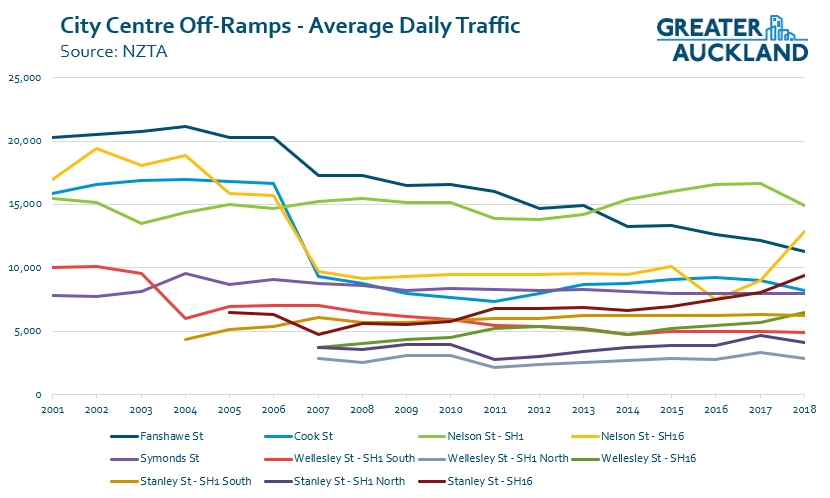
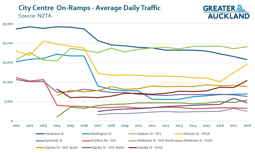
On/off-ramps
There are a few things that really stand out here.
- Fanshawe St: There has been a significant decline in the number of vehicles using the ramps at Fanshawe St. This is likely the result of the opening of the direct link to Grafton Gully at the end of 2006 and the opening and subsequent growth of the Northern Busway in 2008. With so much change, perhaps it’s time consider re-prioritising some space.
- SH16 ramps: The drop in traffic following the opening of the motorway links was significant with volumes almost halving on the likes of Cook St and Nelson St (from SH16). But those SH16 ramps are what now appear to be driving the recent increase in usage with Nelson/Hobson St the most significant. There’s only one thing I can think of that has changed within that time frame that would have caused traffic volumes to jump so much so quickly – Waterview.
- Southern Motorway: It’s a bit hard to see but most ramps to/from the Southern Motorway are either relatively flat or are declining.
City Approach
Due to the number of ramps in and around the city, those charts above are quite busy, so I’ve tried to simplify them in this next chart. Here, I’ve looked at the number of vehicles approaching the city centre from the North, West and South. In each case it starts with the volumes at the last on-ramp before reaching to the city, this means from Onewa Rd, Western Springs and Gillies Ave. I’ve then shown at a high level where these vehicles are going and how that has changed.
Again this highlights that traffic to the city and city fringe from SH1 in both directions has declined but numbers are up significantly from the west – only a small number of which can be accounted for by an increase in heavy vehicles to the port. There has also be increased volumes of North/South through traffic and also from the North to the west – which will also be related to Waterview.
This is notable as I’ve re-looked at the traffic assessment used to justify Waterview and there doesn’t appear to be a single mention of it having an impact on the city centre. I also wonder how much the volumes on the Northwestern are being impacted by the lack of a dedicated rapid transit route. Had that have been built at the same time as Waterview and related works it may have helped to moderate the increases.
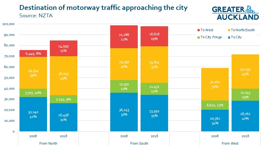
So it appears Waterview has significantly increased the number of vehicles in the city centre, undoing years of work that had seen volumes reduce. It reminds me of this cartoon
I’ve also put these maps together to highlight the current state of the information above with the width representing the number of vehicles travelling.
North

South
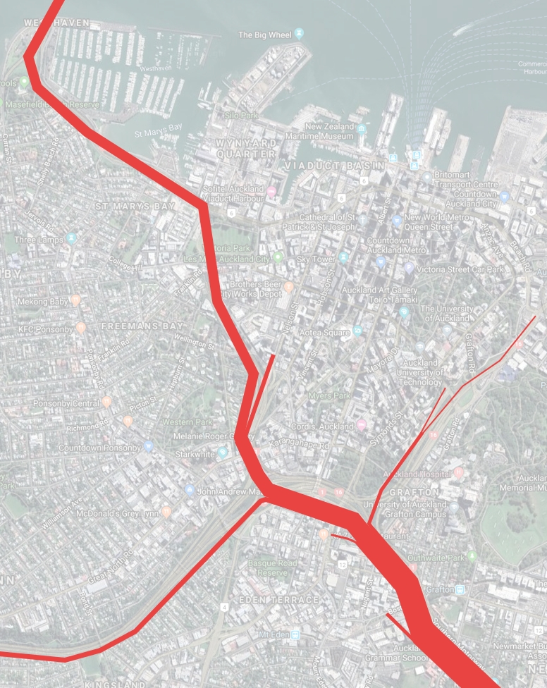
West

It’s interesting to think that the City Rail Link will eventually have the capacity to move more people in two hours than any of these motorways do in day (The Southern Motorway between Gillies Ave and Khyber Pass is the busiest section with just under 100k vehicles per day towards the city.
While traffic numbers across the entire day are up a bit, data from AT over the last few years is showing a fairly steady decline in the number of vehicles entering the city at peak times.

What do you make of the numbers? Do you think we should have an explicit target for reducing vehicles in the city centre and if yes, what should that target be?

 Processing...
If you put the jobs in the suburbs instead of the CBD, problem solved. De-centralisation of employment is the key. Centralisation only benefits the rich owners of the businesses there (so-called agglomeration benefits) , who pass off the resulting transport and housing costs (which increase the closer to the centralisation you get), onto society.
In towns and cities that haven’t gone high-rise in the CBD, you don’t have the resulting high transport and housing costs.
Putting jobs in the suburbs is what we’ve been doing for decades. Currently only about 13% of jobs are in the city centre and about 25% in the wider central area, including Ponsonby, Grafton, Newmarket and Parnell. The dispersal of jobs is a key cause of congestion getting worse in Auckland compared to comparable cities.
It might surprise you to learn that in most cases, couples don’t work in the same place and so it’s not possible for everyone to live close to where they work. Perhaps you didn’t read the post but less than half the people on the motorways near the city are traveling to or from the city. It’s not the city that’s causing the congestion but everyone else.
If the city centre had a larger share of employment it would be easier to justify more investment in higher capacity modes like rail that would get more people off the roads.
I understand from those graphs that most traffic on the motorways in the CBD is cross-town traffic. Decentralisation will make that worse. At least if you work in the CBD you can much more likely take public transport.
Geoff, do businesses want to be in the suburbs?
It looks like when they’ve been forced into the suburbs, they’ll return to the city centre as soon as they can: https://i.stuff.co.nz/national/115839528/suburban-offices-sit-empty-as-city-centre-fills-up
I think the problem many firms face is that they need to interact and trade, which is far easier in the city centre, where distances are short, than across suburbs where distances are long.
Firms that will succeed in a suburban context have plenty of premises at or near suburban town centres to choose. If they don’t want to go there because footfall isn’t high, there’s something to learn from that, too…
Decentralisation doesn’t avoid traffic congestion. Tysons Corner, Virginia is the text book example. It attracts people from the wider Washington DC area by car along the I495 Beltway and is famous for traffic.
Among all the other reasons given to you Geoff which I’m sure you won’t pay any attention to, Businesses like to be together. This is why Cities have become Cities throughout History, because being close to each other meant information and knowledge was shared.
The fact is, my Company is based in the CBD as are all our suppliers and parnters, this makes it easy to attend many meetings on a weekly and daily basis without having to spend all day in a car and killing the environment and productivity.
Would like to see some of your evidence you state around high Rise CBD relevance to Transport and Housing costs. Notably cities of simialr size aka don’t compare Ashburton to Hong Kong. I’d also like to see the data around productivity etc, because those low housing costs might be due to the fact the place is unproductive and undesirable. Over to you 🙂
It’s ok Geoff, I tend to somewhat agree with you.
Many cities have satellite hubs that are connected to the same rapid transit network as the CBD allowing for more diverse employment opportunities. We could have done the same if places like Manukau, Takanini and Henderson had the some loving care as the CBD.
The best way to reduce car dependency is to reduce the need to travel long distances and so creating mixed use developments where people can live, work and play all within waling and cycling distance stops them needing to drive long distances just to either get to work or go to the shops.
Sure not every single person in the household may work in the same neighborhood in which they live, but if one of them does that’s 50% less traffic.
But you haven’t agreed with Geoff at all as he promotes jobs in Suburbs, rather than multi-centralisation which is what you are advocating for which funnily enough is what the Council/Government are ‘trying’ to advocate with their policy of Transit Orientated Developments.
You are right around our so called Centres needing more TLC though and better connected Transit. Look at Manukau’s sea of surface carpakring and subsidised AT Carpark..only one type of mode in which that is promoting.
Agree with you regarding mixed use. However, there will always be a degree of centralisation/clustering of employment as businesses generally like to be near other businesses and also central to the biggest pool of talent possible.
Manukau and Henderson have had plenty of love from their respective councils over the years but they have never thrived anything like the CBD simply because they are not central.
I agree there will always be the big CBD.
Wealthy companies like banks and lawyers will always want their vanity buildings which in turn will always result all the supporting business to hang around.
I’m pretty sure when Geoff says “jobs in the suburbs” he’s not literally meaning random factories and office buildings turning up down in residential neighborhoods but rather not having almost every office job in the city being located in the CBD meaning the average person needs to travel 10-20km to work because they can’t afford to live any closer.
Vanity Buildings? Sorry have you seen the state of the architecture in the CBD?…and there is the thing, its just assumptions without evidence.
In the realm of NZ budgets they are some of the flashest buildings we have.
“and there is the thing, its just assumptions without evidence”
Can you rephrase that please, I don’t have a clue as to what you’re on about sorry.
You are making assumptions and sweeping statements around businesses setting up in the CBD because of ‘Vanity’ buildings with zero substance or evidence.
You mean statements like this:
“This is why Cities have become Cities throughout History, because being close to each other meant information and knowledge was shared.”
There is a lot more reason than vanity for employers to be based in the CBD. My CBD employer (which has nothing to do with banking) has staff from the North Shore, Massey, the CBD, Glen Innes/Panmure, Botany, Mt Roskill amongst others.
If we moved from the CBD to say Henderson, Takapuna or Manukau there would likely to be a significant number of resignations. My employer is happy to pay a CBD rental to ensure we have access to the widest recruitment pool possible.
The majority of my office (75 %) uses public transport, a move to any other of those locations would probably increase driving.
I never claimed the only reason any company is based in the CBD is for vanity reasons, I just gave two examples of companies that could largely be located anywhere with a sufficient employment base but choose to be there because the have the money to pay for the image it gives them.
Once these companies are there they attract all sorts of other companies as their workers need services such as food.
The employment base argument is a bit of a double edge sword, yes the CBD has the best transport connections but they are also the most crowded connections. So you are both losing workers and gaining workers by being in the CBD.
Whatever the reasons for centralization, if you’re sitting in that congestion going towards the CBD, then the majority of people around you are not actually going to the CBD but to the more decentralized places further afield.
People working in the CBD have more tendency to take public transport and thus not increase congestion as much.
So how is decentralization supposed to lead to less congestion?
“People working in the CBD have more tendency to take public transport and thus not increase congestion as much.”
The issue there is that the most effective way to get people to take PT is to make it their best option which in turn means making the other options worse. So to get into a position like we are in now were most people get to the CBD by PT you need to have made driving worse to offset the time penalty. So rather than letting people drive into town in 30mins you need to increase congestion so it takes them 1.5hrs to get in so that way they’re happy to spend 1.5hrs on PT.
Having business’s outside of the CBD may reduce congestion to a degree, but the bigger benefit is that people can get to work faster rather. It can also reduce the need for hugely expensive infrastructure projects such as the CRL (Note: I’m not attacking the CRL, just using it as an example of an expensive project).
This is why Cities have become Cities throughout History, because being close to each other meant information and knowledge was shared.”
Nothing sweeping about that comment Richard, this has been proven a 100 times over, Triumph of the City is a good book to start with.
From my understanding Joe, the rise of cities came about through improvements in farming which meant more of our population was able to specialise in things other than collecting food.
The size and spread of cities were then influenced by the technology at the time along with their function, 1st being based on a reasonable walking/riding distance, then how far you could take a train to today where it’s how far you’re reasonably willing to drive.
The type of specialisation you got in cities was driven by its size and again how far people were willing to travel. So where most people would expect to be able to post a parcel from the town they lived in, if they wanted to buy a new saddle or get a rotten tooth remove they were willing to travel further. Also if you wanted to operate a bar you would more likely open it in a city with a large population (which would generally be a port city) rather then some town with a population of 100 expecting people to train in from 4 hours away to get a beer.
Unfortunately banks are closing all over West Auckland and so areas like Glen Eden (with a train station) or Te Atatu Peninsula (proposed transport hub) don’t have a bank branch any longer. So business staff have to commute to New Lynn, Henderson, Lincoln Road or Westgate to use a bank. De-centralisation needs the support of more than simply transport infrastructure. Less than 1 percent of enterprises (2,560) had 100 or more employees, but they engaged 48 percent of all employees in New Zealand. https://www.stats.govt.nz/information-releases/new-zealand-business-demography-statistics-at-february-2018.
Glen Eden has plenty of banks.
A pint you miss is that some (but not all) of the increase on the NW motorway from Waterview will be substitution, eg airport to city trips would typically be along the Southern motorway pre Waterview, nowadays they are typically along the NW motorway. Though of course the increase on the NW is bigger than the decrease on the Southern.
Still, I agree some kind of “sinking lid” style goal (like is talked about for pokie machines) for private vehicle use would have merit. It would need to be achieved by improving the alternatives and managing the pipeline of long term projects rather than large initial cuts to capacity. Though a steady level or downward trend in private vehicles going into the CBD is what Auckland has already achieved in the past 10 years? Ie we are already on track, just need more of the same, including more carefully directing the long term big projects?
I think you miss a key benefit of Waterview- the reduction in traffic on key suburban north/south routes such as Dominion and Sandringham roads. Traffic from the city no longer uses them to got to the south and airport. That reduced traffic is making it easier for PT and other users
It makes it easier one way, but the PM peak west-bound is an absolute shit-show, on a route with no PT. All it’s done is shift the bottleneck to a place where there is almost no alternative to sitting in the congestion.
That’s because it’s taken the motorway construction between Lincoln and Westgate an eternity to complete! Yes it will induce some more traffic, but by opening up a 3rd lane (and not driving through a construction site) will move the bottleneck from Lincoln to Westgate (several k’s away) and moving the tail further west.
RT is absolutely needed, I’m just pointing out that the motorway works have taken about twice as long as they should have by NZ standards and 3x as long by international standards.
In the meantime they shoulda kept use of the HR line to Kumeu using the old diesels and take hundreds of cars off the road.
This is a post about the effect on the city centre, not a critique of the Waterview Connection, which had different effects on different parts of the city. Should further motorway connections be designed without analysing what effect they’ll have on the city centre? The Waterview Connection analysis also didn’t look at what would happen on the local roads through the inner west.
Yes Heidi, this is not a criticism of Waterview, just noting it’s impacts and that those impacts either weren’t expected or more likely, excluded from the reports.
This is off topic I know but agree – as a regular walker in this area during the morning peak, I noted that the drop-off in the residential streets between Mt Albert Rd and Balmoral Rd, and on Balmoral Rd itself, was also striking.
On topic – the bus service on Sandringham Rd is now so good that it’s easy for me to say “I don’t drive into the city ever” and I also note how many other Gold Card users are catching city buses eg 75 to Remuera. Never been promoted that I’ve seen, however.
Love all your data work. I guess Newton ramps are not defined as in the CC , would be interesting to see their trends.
Hopeless that cc traffic impact wasn’t a concern to NZTA. We’ve got the tools, we need to use them comprehensively to understand the wider traffic and emissions impacts of our investments.
Yes a tough choice as to whether to include them or not but choose not to, especially for the line graphs as they were already busy enough.
But you can see the impact in the stacked graph
I can tell you exactly why SH16 – Nelson St off-ramp traffic has climbed. NZTA’s moronic ramp lights at the SH1 feed.
They turn these on before 3.00 pm most weekdays and the build-up begins quickly tailing back beyond Newton Rd off-ramp. Stopped cars on a motorway lane live land that is very high risk and for no other reason then the boffins who love their gadgets thought this a brilliant idea to keep SH1 flowing. Ever thought of closing Wellington St on-ramp at peak??
So we all deviate into the city to avoid the massive stop-start queue. In fact, they seem to turn them on at a whim. Once it dawned on most people that this was not something that was going to be fixed or abandoned you detour to avoid it. An own goal by NZTA all the way.
Whoever the geniuses were who thought those ramp lights were a good idea are probably the same imbeciles who gave poor old Phil Twyford the finger and syphoned off the Light Rail funds for more roads.
U right
Those ramp lights were installed in 2006 around the time there was a dramatic drop in ramp volumes. I think you are drawing a very long bow suggesting they are the reason for a dramatic spike in 2017!
According to the graph, the growth in Nelson St traffic hasn’t spiked, it’s taken off from late 2015 and kept on going skyward every since.
And unsurprisingly northbound traffic no longer had to go through the city to join SH1 so of course, the numbers dropped. Very, unfortunately, they reopened the Wellington St on-ramp in late 2012 after the Vic Park tunnel was opened and when traffic actually started flowing even better making the link work well and that meant NZTA just could not resist the temptation to use traffic lights there.
But I don’t think the link has ever reached its potential because not only does NZTA put the red lights on from 2.45ish each afternoon but they do it in the morning peak too whilst the bridge is down to 3 lanes northbound and the delay is huge.
And if you agree with this blog site you would believe that there is far less traffic entering the CBD every day according to stats which either makes Nelson Street a liar of that or there is something else happening and I go back to what I experience every day I use it, those ramp lights diverting traffic to Nelson St and rat-running through Freemans Bay or the western part of the CBD fringe on different roads to get back to SH1 via another on-ramp.
Matt L could also be correct, the volume pumping out of the Waterview tunnel could easily be contributing to the numbers but that didn’t open until July 2017, but again I reckon, based on the real thing, NZTA has made it quicker to bypass the link. A very poor side effect of piss poor motorway management.
I mean who the hell would put traffic lights in the middle of a motorway?
Ironically, a system where speed and flow is prioritised.
https://www.greaterauckland.org.nz/2019/04/11/are-ramp-signals-fundamentally-flawed/
As for this example, here’s my anecdata from living in Freeman’s Bay:
– The tailback is real, and dangerous, and leads to worse gridlock on SH16 at peaks
– It consistently blocks the Newton offramp so people drive up the chipseal shoulder. Cops are on the hillside taking photos every once in a while but somehow nobody gets that its a system design issue. People also block the nelson st exit trying to merge into the queue.
– When congestion gets that bad even the buses use the rat run. 134x & other SH16 buses get off at Pt Chev and use GNR to Grey Lynn shops where they divert to the SOV Williamson ave-Ponsonby Rd-Hopetoun St slip lane. Some drivers even cut up Beresford Sq and turn left to Pitt St to avoid queues at Hopetoun/Pitt intersection.
– There are so many rat runs for SH16-SH1 movements and SH16-city whereby the huge unnecessary VPDs and user desire for motorway-like travels speeds destroys the urban fabric of the western city fringe and creates extreme danger and displacement for anyone not in a car. Gundry St, K Rd, Hopetoun St, Howe Street, Wellington St, Pitt St.. That’s just the beginning
– It doesn’t even make driving the Wellington onramp any safer, because people switch into the inner lane anyway, because they know it is going to be kept mostly clear by the system. so drivers see more room to speed up and undertake.
– Wellington St was only reopened because a few Herne Bay gentry were worried the same effects happening to their area instead, so instead of fixing the system NZTA spreads the jam.
It’s really unfortunate that like SH16 PT this is all in the too-hard don’t-care basket for NZTA and as impacted communities we have to rely on local boards and council strategy like the CCMP to get basic local safety considerations.
It’s clear though the huge spike upwards for the SH16-Nelson St off-ramp is from 2017. Interesting the on-ramp climb starts in 2016 though, then really climbs in 2017. Is the 2016 climb to do with ramp signals or something else changing? It could be the peak morning was affected by finishing of Lincoln Rd then Te Atatu Interchanges complete in 2015 & 2016 respectively. Don’t’ know the month off-hand.
What the links done during that quite sharp 2015 decline time, or was the SH16 road works disrupting this & pushing people to the train..ahhhh yes perhaps that & the electric EMU’s were getting rolled out West during this time.
Grant, I don’t think Lincoln Road had a lot to do with it. The new over bridge purpose was purely to allow a wider motorway underneath. They could have done so much more to improve flow but instead added more intersections and more traffic lights and killed any chance of emptying Lincoln Rd faster. It’s a shocker in the morning. Te Atatu similarly changed little.
Did they add more capacity through and on/off these interchanges & SH16 lanes towards the city though? (I’m not that familiar with them myself).
* oh my comment above from yesterday should read:
“Interesting the *Hobson St* on-ramp climb starts in 2016 though, then really climbs in 2017.”
To me it’s worrying how much vehicle traffic has increased in this ten-year period when we know so much about the severity of climate change. I don’t think it’s Waterview, rather it is the lack of investment in transit stations and rapid transit lines. If there’s only one transit line to the West and only one to the North and zero new investment for a decade, there’s only one possible outcome, which is the steep increase in traffic that we are seeing here.
I agree with the concern, and so believe an overt target of traffic reduction needs to be stated. I think there needs to be one for the city centre, and another for the city as a whole.
The lack of investment in transit and active modes, and the investment in increasing roading capacity are of equal concern.
Do you remember this post: https://www.greaterauckland.org.nz/2013/04/05/the-mot-and-the-ccfas/
in which Matt showed that the MoT actually treat latent demand differently for driving, buses and trains. While the whole roading investment is based on meeting fantasy modelled latent demand for driving, they say of the other modes:
“We do not, however, agree with the report’s argument, presented on page 182, that “latent demand exceeds capacity on rail in 2021”. The level of demand refers to only occurs in 2021 when the CRL is in place and is therefore not latent and does not exceed capacity. This is a different issue to the demand for travel by bus, which occurs without the need for significant capital investment.”
Who authored that MOT opinion?
It’s on page 12 of the “Central Government’s Officials’ Comment on the Draft CCFAS Report” https://docs.google.com/file/d/0B0f0ymGg1y-8TFVCMTZIQ3Q4bDg/edit . It says “This note provides comment from Ministry of Transport, NZ Treasury and NZ Transport Agency officials…” and is sent by a Martin Glynn.
“MoT actually treat latent demand differently for driving, buses and trains”
This is a somewhat clear an obvious things however, you seldom see an empty road with legions of people sitting on the side waiting for the next bus to come along. Neither do you see the busway or any of our rail lines operating near capacity in the middle of of the day.
Roads however regularly go over capacity outside of the standard peaks.
This relates to the question I was trying to ask the other week in which you said your preferred mode of transport when your completely unconstrained was bus.
if that were true, its a remarkable land owner cabal that has managed to exist since the first humans created cooperative settlements.
Also there is plenty of potential for employment and other services to have located randomly across the city, rather than clustering but for *some reason* it hasn’t and doesn’t.
Maybe its not a conspiracy but rather the natural order of things?
Looking at the plan it looks as though Grafton Gully will be largely be removed as a vehicle connection so that looks like a pretty big step to removing vehicles from the CBD (I’m assuming the port will need to be closed before that happens however).This would of course send them off somewhere else and so you would need to progressively keep on locking down more and more roads.
Why would the port need to close to deliver the Grafton Gully Boulevard, one of the reasons for it is it includes freight lanes so trucks have better access to the port. It’s even shown in the diagrams

Mainly because it would be a very poor performing freight connection. Restricting heavy vehicles to a single lane would create issues as issues with all freight being limited to about 15km/h.
There would also likely be complaints about the noisy smelly trucks from the cafe owners and apartments that are proposed to line the street.
Where do you get the 15km/h from, other than choosing the lowest number possible from your head to try and backup your claims?
Do you also really believe Cafe owners are likely to close the Ports of Auckland down?
Do you also really believe that apartments can’t exist next to noise? Train lines for instance?
Thanks for the attempted insult, however I got the 15km/h from vehicle stimulation software used to assess the effect of grade on heavy vehicles.
In regards to the other two questions, people buy and move into houses next to stadiums, race tracks and airports and then start complaining about noise resulting in such things being closed down or noise restrictions put on them. So it’s only logical to expect the same here.
“vehicle stimulation software”
Kinky!
It’s the same grade as today, but with shallower curves and eight lanes across instead of four.
Lol, very kinky.
‘It’s the same grade as today, but with shallower curves and eight lanes across instead of four.’
It’s irrelevant because they are shutting the Ports of Auckland down to a noise complaint from John in apartment 32
Sounds like someone is being a bit of a silly billy.
Looking at its declining volume, would closing the Symond St onramp to SH1 South affect the new plans for city centre access??
While there is a large increase in Nelson St-West aligning with Waterview opening, there is also a corresponding moderate decrease in Nelson St-South, and there will also be a reduction in Pah Rd, Dominion Rd, Sandringham Rd.
It will be mostly redistributed traffic, rather than huge induced demand.
Yes think you are correct here.
A lack of rapid transit along north western motorway fueled with popular growth in the northwest is the culprit.
It is a shamed not to build a bus lane when they widened the 16 state highway.
I think the flatish Southern Motorway ramps would be mainly due to the lower south motorway works & probably more so due to the huge success of the rail line uptake which mirrors the motorway alignment pretty close generally (even a big chunk of the Eastern Line).
Zero of course. Keep the motorised vehicles to a ring road, and allow trade vehicles during restricted hours. The Queen Street gully needs to be smog free, such an urban valley will never be pleasant while the air is so un healthy. My interim proposal is to make Nelson Hobson a closed loop, and the Port offramps the Eastern part of the ring road. Maybe not even a ring, just two parallel access to the waterfront. With Albert Park Tunnels, CRL, Victoria Linear Park etc. paradise might just be refound, and there won’t be space for those smelly motorised beasts!
The first graph is interesting. Why is there a difference between the number of vehicles entering the city (off-ramp) and exiting the city (on-ramp)? Are ten thousand vehicles being manufactured in Auckland city each day? Are ten thousand vehicles entering Auckland city by local road and exiting the city by motorway each day? It would be an interesting case study to see where these extra vehicles come from.