Last week the Supporting Growth project released their indicative transport network maps for the greenfield growth areas in the North, Northwest and South. Combined these areas are expected to see more than 130,000 new homes and 76,000 new jobs – basically adding about two and a half Hamilton’s.
But if the council is serious about the climate emergency, and its finances, then it needs to make sure most of this sprawl never happens and these roads are never built.
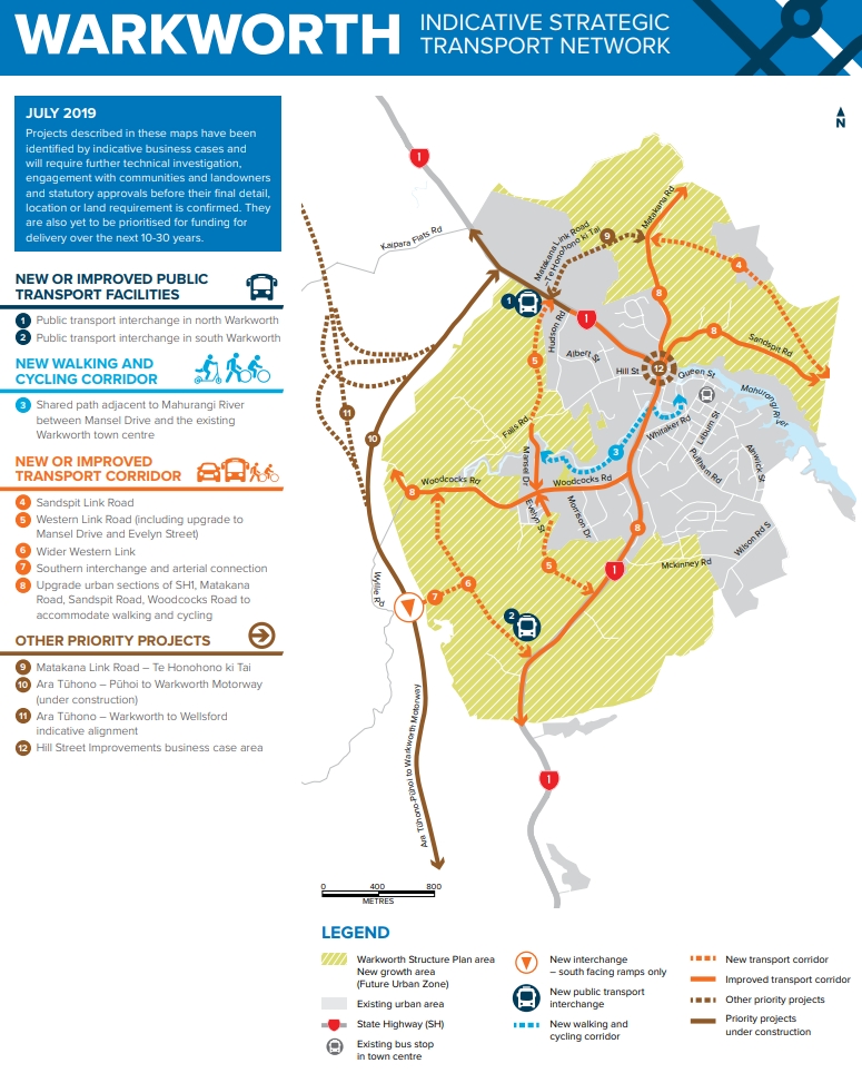
The Supporting Growth programme has achieved a significant planning milestone with the publication of new indicative transport network maps for Auckland’s future growth areas.
The Indicative Strategic Transport Network plans identify what transport projects are needed over the next 10-30 years to support the development of new communities, employment and industrial areas in Warkworth, north, northwest and south Auckland.
The plans are developed by Te Tupu Ngātahi (the Supporting Growth Alliance), a collaboration between Auckland Transport and the NZ Transport Agency, with consultants Beca, AECOM, Bell Gully and Buddle Findlay, to plan ahead and provide certainty to the community and stakeholders about what transport networks will be developed over the next few decades, in line with Auckland Council’s land use planning.
The NZ Transport Agency’s Director of Regional Relationships Steve Mutton says the plans aim to provide safe, accessible and sustainable travel choices that connect these new areas to the rest of the region and promote a greater use of public transport.
“The plans set out a shared vision by central and local government for long-term investment in Auckland’s future growth areas. It shows their commitment to working together over the next few decades to plan, fund and deliver a well-integrated transport network.”
Each of four main areas encompassed by the project were consulted on last year and some of the issues consulted on were issues such as whether the Northern Busway extension from Albany to Orewa stick close to the motorway for speed or divert a bit through all the proposed development.
Here are the indicative networks. Overall there is not a lot of change from what was proposed during the consultations. It is also worth noting that these are just the high-level strategic networks, such as the main arterial routes. If the developments happen it will require a lot more local roads that come off these. Also, while they show some active mode routes, these are just likely to be the main off-road routes as all arterial roads are expected to have separated bike lanes.
Warkworth
They have confirmed they want a southern interchange on Puhoi to Warkworth which even more begs the question of why such a massive interchange if the motorway is ever continued on past Warkworth. One thing that does seem to have been dropped from the consultation are the arterials on the Southeastern side of SH1.
North
An extension to the Northern Busway will divert away from the motorway and through the middle of the development which should mean that stations have a wider catchment which is positive. What’s also interesting it’s not flanked by an arterial road. It also appears, but is not clear, that it would shift the Silverdale station to the west of SH1 and possibly stop in Milldale. I do wonder how long the airport will be able to stay once all the development starts and if that happens, if there’s an opportunity to ease the sharpness of the busway diversion away from SH1.
There are also a couple of new motorway interchanges planned, one for Penlink and another at Wilks Rd.

Northwest
One of the first things to notice is the planned State Highway bypass of Kumeu-Huapai, as well as the first part of any Rapid Transit route, would divert off almost directly after the Brigham Creek interchange. Given the RTN route could initially be just a two-lane busway, I wonder if that part could be prioritised to happen relatively quickly. It also looks like they’re really setting up the bypass to also eventually be extended past Waimauku.
There was also a discussion during the consultation as to whether they build a new North-South arterial or upgrade Nixon/Taupaki Rd. They have chosen the latter which would mean at least it would have some safety improvements.

South
The South still has a bunch of big arterial roads planned, such as the Mill Rd Corridor running all the way from Manukau to Pukekohe. I still don’t see how they’re going to create an east-west connection between Mahia Rd and Rangi/Popes Rd as in ~500m the new road would need to cross the railway line, stream and the motorway. That seems like it would end up a very large and expensive bridge.

While all of this work is really just a future proofing exercise and most of it not expected to until the long term, as mentioned at the start we really can’t afford for all of this to go ahead. The press release talks about the aim being to “provide safe, accessible and sustainable travel choices” but even a high PT and active mode-share in these areas will still result in a lot of people driving. That’s a lot more emissions and a lot more congestion.
The final kicker in all of this is the cost. The press release stating:
Early estimates for the cost of transport improvements over the next 30 years to support the growth areas are in excess of $10bn, with funding to be secured from both public and private sources.
My understanding is the figure is the actual figure is significantly in excess of $10 billion effectively working out at over $100,000 per home, and this is before the costs of delivering local roads off these arterials, or any of the other infrastructure that will be needed. Imagine if instead we took that money and poured it into making PT better within the existing urban area. It could be enough to add perhaps up to a dozen new rapid transit lines across the region which would benefit not only new residents but existing ones too.

 Processing...
This is great work in making us think about how we should provide for the future and still being able to change direction as required and to suit future growth and transport choice.
As far as the Northwest goes, there are already houses there with no access to rapid transport. They would also benefit from the increased connectivity in the area. Good to see it visualised, but wasn’t NW rapid tranist a decade one priority under ATAP? Has this now officially become a decade two project?
Recouping $100k per dwelling using a targeted rate over 50-years with a 5% p.a. cost of capital = ~$5,250 p.a. per dwelling. Broadly the same as body corporate fees for my apartment.
So while the $10 billion infrastructure cost is significant, it’s probably not a show-stopper provided the developments also deliver a broader sense of urban amenity / value.
Personally I think that’s the bigger question for g’ field areas: Given the cost of infrastrucute, can they offer sufficiently high levels of amenity?
Perhaps …
Stu
Who pays the carbon cost if these dwellers choose substantial commutes to workplaces?
they will, hopefully.
Assuming that we’ve moved our policy settings to a point where the marginal costs of carbon emissions are internalised via prices.
What are you suggesting? No-one’s paying for their carbon costs, which need to be in excess of $250/tonne.
As Matt said, the $10 billion is only a lower limit. There’s the cost of all the other roads and infrastructure, too.
Then if “they will” also pay for the other costs associated with the driving they’ll be doing, including the public health, trauma, space for parking throughout the city, road runoff, water pollution, costs, it doesn’t make this an affordable option.
People are keen on this sort of development only because those costs haven’t been taken by the new residents.
I’m assuming these dwellings won’t be built for, say, 10-years. By then I *hope* people are paying a reasonable price for carbon.
And road pricing, for that matter.
At $250 a tonne we could probably convert carbon back into coal and bury in a pit somewhere.
Which humanity is basically going to have to do, by some name or another. All the IPCC scenarios include carbon capture and storage to stay below 1.5 C.
There’s also the external house maintenance extra a body corp normally covers. We are talking standard Auckland local rates on top of this in both cases aren’t we?
yes.
It only needs to be half that Stu. The other half could be paid by residents and businesses in the CBD given that is where the other end of the railway/light rail/motorway is.
yes, fair point. Transport operates in both directions and public transport infrastructure connecting the periphery to the city centre definitely benefits both. In the case of the city centre its largely the businesses that benefit, although they also pay rates so we’re fine.
I’m not exactly sure whether these costs include the city-side? And what do you think is a fair split? Maybe 50% for the RTN and 100% for local stuff, given that the latter primarily benefits the growth area.
In the case of the northern and southern growth areas, the Northern Busway (from Albany into the city) and southern rail line (from Pukekohe to Papakura) are largely complete sans a couple of stations.
So ceteris paribus you might expect those areas to have lower transport infrastructure costs than the north western growth area.
Good comments Stu. This is how green and brown field TOD’s should be funded.
With the added congestion and carbon taxes tilting the playing field towards transit and active transport modes and away from single occupancy vehicles and the internal combustion engine.
But those that can afford to live closer to the city, but still get the benefit of improved choices, don’t have to pay? Think about why people choose to live in different places. Many of the close in suburbs are pretty awful in terms of streets / lack of affordable housing options for families etc. Think of where transport spending is in Auckland and you’ll see we’re doing virtually nothing to make suburbs, even close in suburbs, nicer places to live. The entire focus in Auckland is enabling peak time commuting , and this includes roads, transit and cycling.
Not a showstopper perhaps, but a heckuva lot higher than Aucklanders are used to paying in rates – I think the current average rates bill is somewhere around $2,500-$3,000. And it’s also $100 a week, which is substantial in the context of rents etc.
This is why it would only work for new created property titles. The new residents would vote with their feet. For instance deciding that $5000/year for a TOD house is good value because they can drop a car that costs $10,000/year.
Adding $5000/year to existing ratepayers though would be political suicide….
This means rapid transit if funded by targeted rates needs to have a large brown or green field component. Or a large area of government owned land that can be intensified, like HNZ suburbs.
How do we get it so the public understand the consequences of sprawl is adding vkt to our roads, so that this makes it political suicide?
Spatial planning rapid transit i.e. in Auckland the congestion free network. Congestion charging roads. On-street car parking allocated by pricing and where there is better use reallocated for that purpose (cycle lanes etc). Removing off street car parking minimums everywhere and introducing a carbon tax. These would go along way to making autocentric sprawl not viable and alternative housing and transport options more viable.
Brendon,
I am just perusing the Auckland Council Framework consultation document under, “Deliver clean, safe and equitable transport options.” Nothing about parking – I wonder if they see this as a mechanism as you suggest?
Using pricing as a traffic demand management tool should be there. After spatial planning it is the most effective way to allocating a cities scarce spatial resources. Cities can either target the cars when they are moving and/or when the cars are parked. Space and congestion should be paid for. Hidden car subsidy schemes, like the private sector paying for car parking minimums should be removed. People facing the real consequences of their choices will lead to better outcomes.
adopting road pricing means we don’t have to worry about “sprawl” from a transport capacity perspective. Basically, transport price signals (i.e. road and parking pricing) communicate the costs of certain locational choices.
This is why road pricing is so urgent: The more sprawl that occurs now, the more people who are making locational choices in the absence of important information. And that may ultimately be inefficient in the wider scheme of things.
Price signals are the information the public need to understand the consequences of their location / transport choices.
I think it’s one thing they need, Stu. But there’s plenty of information, too, about how people don’t behave as the “rational economic man” economists assume.
The narrative also has to change. And government needs to be leading, with quality education. They’re leaving the public’s understanding up to the results of corporate messaging far too much.
for sure.
And I personally don’t mind whether these areas proceed or not. If they do, then my only concern is that they cover their infra costs.
In the case of RTN, a larger city with a larger PT network will benefit businesses in the core as well as residents on the periphery. So it probably makes sense to split those costs somewhat. In the case of regional road networks, we should ensure we have approved (if not implemented) a road pricing scheme before any of greenfield areas proceed. And finally, for local infrastructiure, I’d hope these areas cover their own way.
Personally, I’d like to see greater use of targeted rates to ensure new residents contirbute a fair share to the necessary infrastructure.
I think you should care, Stu. It’s not all about transport networks and pricing mechanisms.
Auckland’s ecological footprint needs to be reduced. Sprawl is increasing it. It’s about soil, biodiversity, food security, teenage access to opportunities. It’s about basic geometry dictating the future city’s energy needs.
It’s way too important to leave this up to the market with some pricing mechanisms added.
Surely by now we have might have learned that it would be better to fix the transport issues in the existing residential areas, before creating new problems in new housing zones? Most especially with carbon emissions getting very close to being taken seriously. Light rail to the northwest should be a far higher priority than greenfields development. And clearly the train between Auckland and Northport needs to be made functional so this train can also serve Kumeu etc. passengers. Auckland is already one of the most sprawling cities in the world, with a relatively tiny population, why do New Zealanders need so much space? And I thought it was already decided to build up rather than out?
Because the bits with the transport in the inner bits don’t want to go up or intensify, and unless we all sit around adding no new houses to our housing stock until someone sorts that out, new housing zones are the only thing providing any real relief to home buyers looking for somewhere to actually live.
But absolutely agree, the NW Light Rail should be going in, and Council should only be able to consent new developments in these areas once they meet a certain scorecard (proximity to rapid transit etc).
The flipside is that as there is no rapid transit in the North West servicing the existing, the cost can be spread over existing housing + any new development + the recovered productivity currently lost from hours per week in congestion. We just need NZTA to actually do the business case bit.
I agree with you.
Any broad figure for brownfield development for the same population/ housing increase to compare with? Also that $100,000 was just the transport aspect, doesn’t include the three waters, rubbish disposal, parks, sports, libraries and other amenities.
Thanks, Matt. You’ve said it straight. We cannot allow this “Supporting Growth in Emissions” programme to go ahead.
What I think the planners don’t get is each household on the outskirts undermines the benefit of probably hundreds of households built as part of good density.
The 100,000’s of other homes we’ll be adding into the isthmus will bring benefits of more connected communities, less vkt through better public transport and because vkt goes down with intensity (Don’t believe it? Look at Barcelona’s vkt for 3 million people in a small area).
Putting even 100,000 of these homes on the outskirts will negate that intensification benefit by increasing vkt everywhere. Those sprawl households end up with car dependency and their travel is so much higher than average households.
Allowing even a little sprawl is how to have neither cake nor get to eat it.
Auckland’s 1.6m people live in 4894km2, Barcelona’s 5.3m live in 4268km2. I love how we have so much space.
Well yeah, you’ve just shown it there, nearly x4 as much
Not only Northwest, aka Westgate to Waimauku but also Northeast, Whenuapai and Hobsonville are hopelessly marooned in car reliant transport. SH16 is abysmal southeast of Hobsonville Rd now at morning peak. SH18 equally so toward the North Shore. The pressure these areas are bringing to bear on the motorways is awful right here right now and of course worsening. I am hoping AT are not deluding themselves that an extra number 114 and 122 bus service here and there is going to do a thing.
There is no strategy that i can see planned that can deal with this mess, only far too little far too late ideas which is what these plans are really about. And that’s the really worrying thing about this uncontrolled housing.
Yes. I think the Council planners have to fight so hard to try to get any rapid transit in, they give up on the bigger issue: that the sprawl shouldn’t be happening anyway.
Then again, I saw some tweet about last night’s Auckland Conversations on density suggesting the Council planners think density is hard because of our hills.
Ha ha ha ha. Roll me out the door. Hong Kong? And the isthmus has a lot of flattish land.
The invisible hand of supply and demand will play a big part in our future growth.
Qualified people are coming to NZ and we need to give them and all of us choices so as to make NZ the best place to do business. Lifestyle, amenities, work conditions.
So for say an IT business operating in Auckland and with customers in several countries it will need to be competitive and employ staff to live a place best suited to them. For a manufacturing company that needs to bring together many components for its products high transport costs will hinder growth.
Auckland is a very desirable city but I feel sprawl should be reduced.
I understand council’s final solution (once all areas are developed) but it isn’t clear how their interim options will work as the land is developed piece meal.
In the Silverdale West / Milldale development it doesn’t appear to leverage existing infrastructure / bus services well. If new occupants are to utilise the public transport then services need to be convienant and in place before they arrive or they will continue to use cars. I fear that bus services will arrive long after driving has become entrenched.
The challenge will be continously adapting the transport options as land is developed and planned routes become available. I expect the solutions proposed here will be decades away (if at all). Concerntrating on the main transport hub in each area and indicating a progressive bus loop as developments grow would make more sense in my humble opinion.
To be clear. I mean that transit oriented development in green and brown field areas should internalise their infrastructure costs by using a targeted rate on the created property titles to pay off their infrastructure costs/debt. If the debt means Auckland Council exceeds its debt limits then a Special Purpose Vehicle can be created which would be independent of local government so not restricted by the debt limits.
Is a special purpose vehicle to sidestep the debt limit wise when the debt limit is there as a check on good governance?
The Special Purpose Vehicle itself will need a sound business case to get debt financing.
A good concept but will never happen as planet warming and its resulting erratic weather patterns and sea level raises will make sure it never happens.
NZ is already facing a $8 billion and growing bill to start future proofing our critical infrastructures from erratic weather and sea level raises, so where is the money is going to come from for Auckland’s urban expansion?
As a country, we need to take a serious look and implement long term plans in our urban housing and transport planning, how are we going to grow food under ‘farm to suit land and climate’ scenario and so on.
Urban sprawl is the not the answer, intensified urban and transport long term planning and implementation is the answer to reduce carbon, etc footprints in our main centres and regional cities.
Planet warming and its resulting erratic weather patterns and sea level raises doesn’t care a damn about humans so us humans will need to adapt or face severe consequences.
We’ve got nearly 60,000 densely living in the city centre and we can’t even get money for missing footpaths.
But 100k for each home in sprawling suburb is no problem.