Before I start this post I’d like to thank Cornelius from Frontier for the wonderful images.
Complaining that public transport in Auckland is of low quality is so accepted amongst the public that most people don’t bat an eyelid when it’s suggested. In fact, most people will probably jump in with their own tales of woe from trying to use it. To be fair, is there a city in the world where locals think their PT system perfect?
Despite the rhetoric, PT in Auckland has improved significantly over the last 10-15 years and these improvements and others are clearly reflected in the numbers, with ridership nearly doubling over that time.
Perhaps one of the important changes we’ve seen over this time, and has mostly happened in only the last few years, is that there is now a broad consensus both at a political level and by officials on what needs to be done for the future. In particular that priority needs to be given to building region-wide Rapid Transit Network. As such, the next 10-15 years is going to be equally, if not more transformational as we build out and optimise our RTN.
![]()
Key parts of that are now underway with four major projects under construction, or just about to be. These are the City Rail Link, Eastern Busway, Northern Busway extension and most recently, the first stages of the Airport to Botany line.
But while the people who read this site are probably aware of what’s planned, I wonder how many of the tens of thousands of others who catch public transport daily know what’s being done to make things better and expand the network, let alone the rest of the general public sitting in their cars. For example, how many train users actually understand what is going on behind the walls Britomart when they get off the train each morning? Even many of the people working on the CRL don’t seem to fully appreciate what it will do to the entire rail network. How many Northern Express users know the trains even exist and that they can transfer to them to extend the reach of public transport (and visa versa)? Do people even know the Eastern Busway is under construction which will enable them to easily reach Pakuranga and eventually Botany? What about the plans for a busway from the airport to Puhinui as well as light rail through the Isthmus and to Mangere?
Given many people are still ‘discovering’ the rail network and Northern Busway, for most it will probably require these projects to be completed and services operational before most properly understand them. However, I can’t help but think that Auckland Transport could be doing more to ‘prime the pump’ and help show that improvements are actually happening. Here are a few ideas for how AT could do this.
Brand the RTN
The Underground, the Metro, the Subway – many cities have effectively branded their rapid transit system to distinguish it from other parts of the public transport network.
In planning documents our rapid transit network is specifically defined (map above) and currently about 28% of all boardings take place on it but as the network expands that number is only going to grow and could easily double. So why not come up with a specific name/brand for it.
AT already use the Metro name brand to the wider PT network so that one is out but how about a name from a past proposal such as Auckland Rapid Transit or ART for short. I’m also sure some clever marketing people could come up with a lot of fun ideas to incorporate that name into campaigns.
Treat the RTN as a single network
Again in planning documents, AT do treat the RTN, and even the wider PT network as a single network. But on pretty much all of their customer facing material, buses, trains and ferries are treated completely separately. For example, the bus network maps show the rail line but don’t mention there are services on it. When there’s a fault on the rail network, AT say that HOP cards will be accepted on buses, rather than reminding people we have integrated ticketing and fares. Even when they talk about the impact of the new network, it’s only buses they mention, even though the design of the network requires many people from South and West to transfer to or from a train for part of their journey.
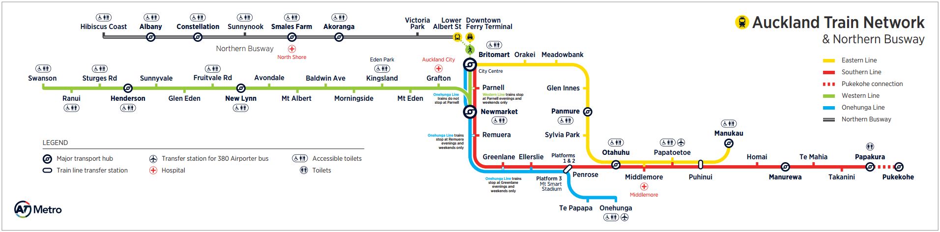
Perhaps about the closest we’ve had comes in the form of the strip map that appears on our trains – 8 per carriage. A few years ago the maps were updated to include the Northern Busway – although again the busway feels very much tacked on as an afterthought and so is another reflection of how AT treat buses and trains as separate things. This is further reinforced by the “& Northern Busway” text and that despite being a core part of the Rapid Transit network, these maps don’t appear on the Northern Busway or the buses that run along it. Also, if you look at the versions of these at the entrance to Britomart, you’ll notice they don’t include the busway at all.
Show what is being done
Thinking about that strip map and how it will need to change in the future was the inspiration for this post. Put simply, it is not designed in a way to be able to easily updated in the future as these new lines start coming on stream. In fact it doesn’t even represent now that well as we have the NX2 services that go via mid-town to the universities.
Instead of constantly redesigning it, why not come up with the future state now and then also use that to highlight what’s planned. This is is where Cornelius came in to help me visualise it. The goal was to flatten the ATAP map above into a map that could fit on the train in place of the one above. It should also be at least put on the NX1 and NX2 services. We wanted to show lines that are under construction or at least in more detailed stages of planning on the map in grey.
Firstly, here’s the network as it exists today along with the current projects under construction or likely to be completed over the next decade. The solid lines indicate there are some form of services currently but not the full RTN infrastructure – NX servives and trains to Pukekohe. You can also see the ART name.
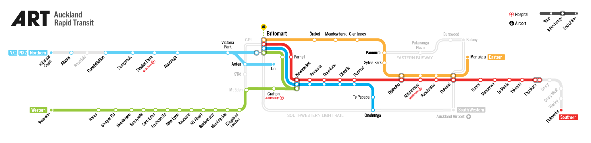
The biggest omission here is the NW route. This is because the priority is on the City Centre to Mangere Light Rail project and so there’s less going on here.
Of course, we can’t just stop there when drawing maps so when the these projects are completed, this is what it might look like, along with the next likely cabs off the rank shown as in progress. These include Northwestern Light Rail and an Upper Harbour line.

And another version with those lines completed.

Finally with a bit of extra flourish, including converting the Northern Busway to Light rail and an additional line from our Congestion Free Network to serve the western North Shore.
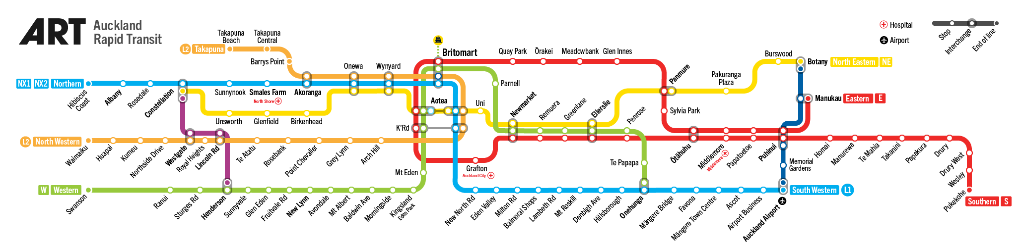
There’s even an animated GIF version

Showing what the future plans are isn’t something new and after we started work on these I came across this example from Tyne and Wear from after they started building their metro network As you can see they also showed the parts that were under construction. There are likely other examples around.

AT and other agencies have seemed to have had a reluctance to promote things “under construction” other than in project specific information but with so much underway, perhaps now’s the time to change that.

 Processing...
Looks good and should be rolled out immediate (in which we know AT wont)
Just one comment:
The second Map where you show Airport to Botany stopping at Puhinui you might want to extend to Manukau where the 36 will actually terminate (even if it needs to be a dashed line from Puhinui to Manukau) otherwise there will be confusion.
The other thing in the map when the CRL is open is the train that will run from Henderson through Grafton and on to Otahuhu .
And the GIF map is the one that should be installed in the 3 ciy Railway stations to show commuters were and when the routes are/going to be .
The other thing in the map when the CRL is open is the train that will run from Henderson through Grafton and on to Otahuhu .
And the GIF map is the one that should be installed in the 3 city Railway stations to show commuters were and when the routes are/going to be .
Have there been any user PT user satisfaction surveys done that can’t be touted to counter perceived poor service?
…can be…
Every month in AT Board reports.
100% on showing what is coming – needs to be “real” i.e. budgeted and planned though. Otherwise people will stop paying attention!
A good opportunity for my usual complaint that we call the train lines “Southern” “Eastern” etc in the apps and timetables, but when I get to Britomart it says “Manukau” or “Onehunga” and I have no idea what train I actually need to get on….
+1. Needs to be real.
The Tyne and Wear map shows ‘under construction’
These Auckland maps are complete fiction where LR is included since there is no LR under construction and it’s looking less likely any physical construction will happen in this gumints term. Drawing lines on a map doesn’t mean it’s going to happen.
Nice artwork though.
Yeah there were dinosaurs saying similar things 15 years ago too.
If you wish to strengthen the political will for LR, sing its praises.
If you want to support the anti-LR brigade, and try to slow its path, keep casting doubt on it.
i was just pointing out that a comparison to TyneWear transport map/figure was not kosher. I have used various opportunities to promote LR, my latest was seriously suggesting an LR clipon to the harbour bridge and I have often said I want NW LR. My enthusiasm for LR falls on deaf ears. My disappointment with LR inaction has blunted my enthusiasm. I fear after the PM’s broken promise for LR in 4 years and a transport minister big on announcements but a failure at delivering PT, that all the LR talk will always be just that – talk.
However, I do have one small faint flicker of hope for LR, the impending budget will announce several $m for LR early works starting this year. Please tell me Im not dreaming again.
Well I certainly share that hope! 🙂
Bogle. Twyford is still firm on LR to upper west within 10 years of that original announcement, so make that 8.5ish years as of today. And this is after that public meeting where NZTA I think it was fudging any commitment.
Bogle – “big on announcements but a failure at delivering PT” – just wondering, exactly how fast do you envisage delivering PT should be taking?
I presume you are not talking about months, but that you at least recognise it will take years. Commission consultants, design and plan out the track layout, design and evaluate all the stations, have them QS’d and value engineered, design bridges, design tunnels, hold resource consent hearings, put it past a planning commissioner, draw up for building consent, submit for building consent to a BCA that actually doesn’t know what it is looking for, so it takes a while, pose several hundred RFI, answer several thousand RFI, eventually gain Building Consent, tender the packages, appoint contractors, search for all the services, move all the services, build route, lay track, lay signalling system, reinstate former services, order trains, wait for trains to get built, and then commission and test the completed system. At a reasoned guess, I’d say 4-5 years minimum is likely, probably more like 10 in the end.
But you, armchair critic extraordinaire, think it should all be done by now?
Waspman, So I understand, he is firm, he has said so. What he says goes, right? Lets do this, stand firm, he is us, we are us, we want NW LR, its firm, its us, go LR,
she’ll be right tomorrow, 8.5 years of tomorrows left, plently of time, be firm, be Phil Twyford, he is us, go NW LR, it will happen, on the way, nuf said.
Guy M, actually I completely agree with your asessment of time and the boxes that need ticked off.
What I get, or dont get, is the big talk about the plans for Aucklands future rapid transport but we seem to be incapable of just getting past the earliest first step in the whole necessary convoluted process. Its the on again, off again, on again announcements that have me confused.
I know we can do a lot lot better, just look at the first stages of CRL from Britomart up Albert St, that was completed in a very few years. Why cant the same ‘can do’ attitude be applied to get the LR up Queen St, surely thats a much easier project when compared to AlbertSt tunnel.
I attended that Labour party meeting at Henderson where the NW LR was trumpeted as the only real RT solution for NW. “Lets do it once and do it right” was the mantra of the day from Phil Twyford. No silly bus RT needed. But later his infamous “Money doesnt grow on trees” was the explanation why there may not be NW LR, but he was firm on his 10 year promise. Yay! Go Phil, go Labour.
Bogle you have to let it go, you regurgitating old arguments again. Stay Calm and Carry On, there is progress and Norwest Auckland’s turn will eventually come. Lets get the Puhinui interchange built, airport rapid busway underway, Ameti moving along and NS busway pushing north, and CRL next stages happening, new Emus arriving, Otahuhu 3rd platform and loop, then Henderson 3rd platform and works underway. Be patient, not everything for everyone can happen at once. Can you notch back the sarcasm level a bit too. FART very funny. 🙂
Bogle, simply quoting a Minister of the Crown.
We had 9 years of nothing but budget cuts to virtually all public services with the exception of motorway initiatives from National plus a surging population as discussed last week. Even the North Western was rebuilt without public transport being factored in, how unbelievably retarded is that??
Twyford has achieved almost nothing thus far but Rome wasn’t built in a day and the pent up demand on all public service fronts is, I think, unprecedented.
To me the jury is out, see how things shape up by 2020 to see if there is any measurable progress.
I wouldn’t say he has achieved next to nothing. Since he has become minister we have had:
1 CRL being expanded to take 9-car trains
2 Eastern Busway construction commenced
3 Hamilton trains confirmed
4 Contract signed for Puhinui Interchange
One, three and four were a pipe dream under National, while the second had stalled for years. I agree there hasn’t been much progress on light rail and a couple of other things, but like you I will pass judgement in 2020.
Jezza , with #3 that service that has now been pushed backed , but we can’t blame the Transport Minister for that , the people to blame are KR as they have to get parts from overseas why I don’t know as the carriages were all upgraded at Hillside .
This is the article that came from the TRON Fb page via the Herald :-
https://www.nzherald.co.nz/hamilton-news/news/article.cfm?c_id=1503366&objectid=12233967
“I know we can do a lot lot better, just look at the first stages of CRL from Britomart up Albert St, that was completed in a very few years. Why cant the same ‘can do’ attitude be applied to get the LR up Queen St, surely thats a much easier project when compared to AlbertSt tunnel.”
The tunnelling under Albert Street started in 2016 and won’t be ‘finished’ until 2020. The ‘finished tunnels won’t have tracks signals or centenary.
The tunnel designation was granted in 2014.
You are right that this section was built quickly, but from designation to ‘finished’ was six years. Maybe stop bashing Twyford for working within the constraints of the law and existing construction methods.
SB, Six years seems a stretch. I thought it was between three and four years but depends largely on what you define ‘finished’ meaning.
https://www.cityraillink.co.nz/property-owners-1
‘On 10 November 2015, following six appeals heard in the Environment Court, the CRL designation was confirmed.’
Then excavation starts mid 2017,
https://www.nzherald.co.nz/nz/news/article.cfm?c_id=1&objectid=11892156
Tunnel completion mid 2019 then to end 2019 reinstating Albert St.
https://www.cityraillink.co.nz/albert-st-lower-area-city-rail-link-construction
Did I miss several years somehow and the Albert St tunnel really took 6 years?
As for Phil Twyford, he is a grown up and as a politician should expect robust criticism of his performance as a minister. But, like others have said, 2020 could be judgement time.
“Did I miss several years somehow and the Albert St tunnel really took 6 years?”
No, as you just said, and as anyone walking up Albert Street could see, it isn’t finished. I had forgotten about the appeals on the designation though so you are quite right. Next year will be five years to ‘finish’ the tunnelling and recovering, but still not have tracks, wires, or signals.
Let’s not forget that the designation application was lodged in 2013!
I think there is a balance to be found. I agree if they don’t happen people will loose interest but I think it could actually help public approval of these projects, this is always beneficial as it means other governments are less likely to drop them.
I like the idea of branding the RTN. I suggest calling it ‘Purgatory’.
A special line just for you, prehaps.
Ah Miffy, A Wellington welcome awaits.
I prefer Future Auckland Rapid Transport or FART for short
+1
The strip map, while admirably comprehensive, is quite difficult to follow, especially for a new user. I’d suggest that it would be better to use a map that more closely follows the geography of the city.
The strip maps suit the spaces available on buses and trains, though. I’d suggest both should be used, with identical colouring, line type, names, etc, and where there’s space in the stations, should be placed next to each other.
I agree with you – Auckland is not a horizontal linear city!
These maps are great and a big improvement, but they are trying to serve the horizontal area above train windows.
There’s a more suitable portrait spot next to the train doors that would be more suitable. Currently used for AT messaging (and perhaps advertising?) so hopefully an easy replacement.
Agree, if you to any other city with a network that is too big for a strip mapm such as Sydney or Melbourne they just find somewhere else in the bus, train or tram to put it.
The only reason it is a strip map is because our rail network is so small.
AT certainly have the advertising space, since they currently waste all that space in and around PT services threatening people to pay up or else.
But, as this site has frequently observed, 20 minute frequencies do not constitute a rapid transit network, no matter the spin. And were I to need to go to the Shore I might contemplate using the Northern Busway if I had an idea where it now connects with the rail network but that link isn’t legible to casual users when you’re at Britomart. Actually, at some other interchange stations, notably Newmarket, the connections seem actively obscured or difficult to access thanks to priority given to traffic flow and vehicle parking.
Well for frequency the Busway shows up rail badly. Twice last week I had to go to the Shore and both times returning to the city I didn’t even break step from approaching the station straight onto a service; 2min frequencies gives you that.
Additionally these schematic maps are not wayfinding maps, but indicator ones. Local accuracy is not the point, but communication of the big picture. The idea is that a rail user like you can see that the NB is transferable to from Britomart, but this map isn’t designed to show you how. It’s bigger picture than that.
Also the current AT strip map is still overly mode focussed; it doesn’t treat the NX1 and NX2 as lines, which it should.
Network, not mode, thinking is a tricky change to make, it seems, even for the pros….
There’s the issue, the Northern busway doesn’t connect to rail, you have to find it, tucked away in a shitty construction site road, at least for now with few spaces for buses. Theyll move it one day ,again, and you’ll have to go looking, again.
Auckland simply will not house the modes anywhere near together to seamlessly connect to for ease of use. Rather we have a clusterf@%k where you need to have an intense almost obsessive interest in the network for finding connections between rail and elsewhere in the city CBD. This has to change!
iirc lower albert st/quay st is going to be finished next year for the boatrace. then the wellesley st bus-only corridor, accessible by LR up queen st.
it’s not the distances, its making the pedestrian environments better by reprioritzing. A4E
Yes, well. Under A4E would the person that killed someone on Queen St yesterday morning have even been driving there?
Under A4E would the driver that hit the person on Symonds St yesterday afternoon have even been driving there?
Unless AT moves from the generic “we support A4E” into “we’re implementing this part here now, and that part there next month, and the final part there, next year”… we’re going to continue to see unnecessary death and injury. If anyone is holding it up, they need to realise they have blood on their hands.
Yes of course I agree it’s achievable.
It’s all linked and the end result will be greater than the sum of parts. Drunk driving, local movement, safety-oriented place making. So many factors to progress on all of them.
The opposition of those who say it’s not worth it, those who say they can’t leave their cars at home, need to be reformed not appeased. It’s Auckland’s gun debate.
It’s not only the distances, although in the rain that is a pain in the arse in itself, rather its the fact that to navigate Auckland by PT means finding a connecting service is akin to searching for buried treasure. As you leave the ferry buildings or Britomart to make your connecting service you somehow have to know what street (or what part of the street) this week and in what part of the greater CBD AT have placed your connecting service departure point.
It’s a terrible, discouraging, totally un-user friendly way to run a so-called integrated PT system.
We do have road works, etc, making it more tricky. Yet I completely agree with you, as our need for constant, incremental improvement means we will always have road works, etc. Their wayfinding needs to be so good as to overcome this.
When Journey Planner is *still* directing pedestrians as if they are driving – through service stations, over major roundabouts, etc… AT needs to put some focus on wayfinding:
1/ for reasons of safety
2/ for reasons of modeshift.
Which happily coincide with AT’s top two priorities.
I guess what I am trying to say Heidi is AT, put the buses in one place namely very close to Britomart or in the future spread out to one of the 3(?) CBD rail stations. Yep, it will cost, but anything less keeps us firmly in the current substandard era where compromise and “that ‘ill do em” attitude rules supreme!
Doesn’t make sense to me to spend a whole lot of money on a bus facility near Britomart that would only be needed for five years until CRL opens anyway.
Better to put some decent investment into wayfinding.
No Jezza, the time is now. Our PT needs this sorted now. The way nothing connects is a debacle!
A bus station that takes all services going into the CBD would be a significant piece of work. By the time it is consented, designed and built it would likely be obsolete as CRL would be ready to open as well.
Seriously waspy, do you get just how many buses come into the CC everyday? If we didn’t distribute them smartly there would have to be some vast area with no city, only buses, bus station, and approaches.
Anyway, a key point of this post is to show the value of thinking of a network made up of lines. Especially running, and communicating, the top-tier bus services like lines: NX1 NX2, soon to be NX3. And the very point of these different high frequency lines is that they go to different CC destinations… So people on the busway can chose between downtown, Midtown (unis), and the P Rd ridge.
Plus we are building the CRL in part because there is limited utility in dumping everyone in one corner of the city.
So no. We do not want one place where every bus and train goes in the CC. But a legible and well communicated set of main options distributed to the main attractors.
Waspman, the network plan for Auckland has everything connect to everything else once the CRL is finished and the bus corridors are reinstated where they are supposed to be. However, they’ll do these connections across four points (Downtown, Midtown, Wynyard, University), rather than one enormous station. Every rail and bus line will serve at least two of those interchanges allowing you to connect from every line to every other line. Well, except the ferries due to the fact they can only go to downtown, they’ll miss a direct connection with 1/4 of the bus routes (of which half are from the north shore, so no huge loss).
As it is, these four interchanges will need to be large facilities and will span more than one street across a couple of blocks, so yes, there will be a short walk to connect most of the time.
But the alternative of bringing everything to one point is impractical. There are around 350 buses an hour coming into town at peak. At a terminus you need a minimum of one bus bay for every six buses an hour, ideally double that to ensure really reliable staging and timekeeping. Have a look at ATCOP online, each bay needs to be 15m long with 11m separation between them.
So around sixty bus bays for 350 buses. Grouped into stops of two or three bays, and split around four locations, that is functional and achievable.
In one place, well that’s a different story. That place would need to clear twelve buses in and twelve buses out on every two minute cycle of the lights. It would need around 1.6km of continuous bus stops, say eight platforms each 200m long. It would need all the circulation space to accomodate around two dozen buses in motion at any given time. The tracking on a bus is huge, you need a 30m diameter just to turn around, which is why the easiest thing is usually just to drive around the block.
I mean sure, there are places that have built those sorts of facilities as enormous underground stations with multiple portal ramps, Brisbane being the closest. But do we see that as viable for Auckland? It would surely cost into the billions if you could find a place to put it.
I get the thing with the roadworks and everything, but still… is there really nothing we can do to improve the wayfinding? Just making bus stops more prominent would help. I have a smartphone with GPS and internet and even then I am barely able to figure out where to go.
We should also improve the ‘level of service’ for pedestrians at traffic lights. If we are supposed to walk half a kilometre between buses, at least make sure not to add extra minutes of waiting unless necessary. I end up crossing against a red man because no cars are crossing my path every single time.
Also, how much of that hassle is due to every single of those buses terminating at Britomart? Can’t we have any through-routing over there? Line 881 was quite successful.
Roeland , what they need to do is to go back to the old days were they painted 2 black rings with a silver center on a power pole which denoted were the bus stop is and the sign was above that , and I agree with you some are very had to find .
What is the definition of Rapid Transport? To me it’s something that is rapid, goes above the posted speed limit in its area of operation.
Our trains are rapid, at least on the eastern line and to some extent on the southern, and very occasionally on the western. Our rail services are a massive improvement on the awfulness that was there in the 90’s.
The Northern busway, although slower than the motorway on a good day is rapid when compared to the suburbs it cuts through and south bound to the harbour bridge at peak, less so north bound at peak.
But it would be a total misrepresentation to call the rest of our public transport rapid, it’s the antithesis of in fact. Less than an average 40 km/hr (probably less than 30), easily for a trip, rarely if ever reaching the posted limit. It’s better in some places service wise, worse in some areas. And I can’t use it to commute to work because unfortunately I have to cross the city and start by 7.00 am and our bus services are still back in the day where starting at 8.00 was the norm. So AT have an awful long way to go to claim Auckkands PT is anything but low quality.
But here’s hoping the LRT thing will a), happen and b) expand. And the CRL plus improvement to the rail network around Otahuhu will aid in its transformation there too.
Rapid is clearly defined in transport planning as primarily a function of separation and frequency. Our rapid network; rail and the Busway, approach these ideal conditions but neither fully achieve it.
The Busway gets closer; very high frequency, but of course merges with general traffic across the bridge, and at city intersections to some degree.
Rail, outside of the peaks, is too low frequency, anyway is mixed with other traffic; both freight and at level crossings.
It is very generous to include the Onehunga line at all on these maps, but makes sense for completeness and clarity.
However the current transit revolution in Auckland has largely been built on incrementally improving these and other services in ways that creasingly bring them closer to full Rapid conditions. This continues.
Low rail frequency is really the most critical failure at the moment. More track so freight and Metro can separate more and more over time is going to be an increasing issue as both grow.
Improving priority for arterial buses too.
Agreed.
Re the Onehunga line. Its not exactly quick as in speed on the branch nor frequent, but it is very direct to Britomart and has the potential to be so much better. So in my mind it’s better than taking the car and a winner in PT.
With the quick connection onto the Western line at Newmarket, my wife can get from Tepapapa to Grafton station in 14min.
Good connections work for commuters. Freq is needed for adhoc trips = what is needed for mode shift.
More track to separate metro and freight has been on the cards for near 10 years now. Why is the need for more track, such as the W2W 3rd main, so obvious to you and many others yet it never ever gets serious attention. This gumt seems no different in that regard to the previous clowns. The convoluted process of AT having to apply to NZTA for funding for KR to build 3rd main when the gumt should just fund such a strategic resource is showing there is likely another clown heading the transport ministry.
To me, the OP comes across as rather pointless. I guess it turns on the definition of what constitutes quality of service and how relevant quality is to the somewhat arcane “transport planning” definition of “rapid” used in your post in the minds of the general commuter.
For example, quality is (to me) determined by customer satisfaction with their PT experience. If the average commuter uses the rail system ten times a week (going to and from work) and is affected by a service disruption once a month then the “rapid” rail network has (a very poor) journey reliability of 97.5% for that commuter. Remember, people have an expectation that their private car will run reliably for YEARS without an unplanned disruption.
So “rapid” is meaningless if a quality failure means once a month a commuter is left standing about with little information for hours waiting to get home, because of a signalling or track failure or whatever.
IMHO, quality is an equation that includes not just speed and frequency but also reliability and customer service. Talking about a RTN without consideration of all other factors is to me a meaningless conversation.
There is a service disruption more than once a month on the motorway network.
True, the entire motorway network is one big disruption on a daily basis.
Yes but does your car break down every week?
A car breaks down/crashes everyday on AKL motorways, disrupting that network…
Zippo – No, but my car doesn’t rely on overhead wires, signals and tracks. Instead it relies on other drivers and other cars, which fail much more frequently than the three things I listed above.
No, but my car doesn’t rely on overhead wires, signals and tracks. Instead it relies on other drivers and other cars, which fail much more frequently than the three things I listed above.
Congestion doesn’t really count as “disruption”. It slows you down, but it happens every day and it is fairly predictable. So you can plan for it.
An example of something I would count as a disruption is an accident on the harbour bridge, which will leave you stranded somewhere on the motorway for an hour longer than expected. That only happens a couple of times per year, which seems to be way less often than faults on the train network.
I wasn’t thinking of congestion, I was thinking of breakdowns and accidents. They occur daily on different parts of the network and can easily add 10 – 20 mins to a commute, definitely more common than disruptions on the rail network.
Incidentally the disruptions last week added about 10 – 20 mins to my trip each time and a much more crowded train. If they happened twice a week every week it would be a big problem but they don’t
“Rapid Transport”?
I assume you meant Rapid Transit. This is how encyclopaedia Brittanica defines rapid transit:
“Rapid transit, system of railways, usually electric, that is used for local transit in a metropolitan area. A rapid transit line may run underground (subway), above street level (elevated transit line), or at street level. Rapid transit is distinguished from other forms of mass transit by its operation on exclusive right-of-way, with no access for other vehicles or for pedestrians.”
https://www.britannica.com/technology/rapid-transit
And that’s how I’ve always understood it.
Auckland Transport has a different definition. I suggest you read the Auckland Regional Public Transport Plan, section 4.1.
This is a quick excerpt that notes that rapid transit can be rail or bus but it requires both high frequency and a dedicated running way. It also notes that our rail doesn’t meet the full service level definition for rapid transit, and the busway has sections without a dedicated running way.
•
• • • •
RTN services operate at least every 15 minutes (currently rail achieves this frequency only in
the peak), on dedicated right-of-ways (rail and busways, though routes on the busway have
segments without right-of-way), removed from the congestion of general traffic lanes.
And I’ve said it before, but motorway shoulders are not part of the RTN.
Indeed, which is why they acknowledge that their RTN services aren’t in fact all to the standard of RTN. Nonetheless, the Northern Busway and the trains do work pretty well all considered.
I suppose Auckland transport can now declare that its ferries are hydrofoils or that it’s humble buses are now limousines….
I’d forgotten about Encylopaedia Brittanica!
It’s still a reliable source for information. Unlike Auckland Transport and a certain mouthpiece (probable employee) of theirs.
Flip it 90 degrees. Many people interacting with this will be doing so on a phone and so the orientation could be better.
Vertical versions are easy to add; these ones are not for that purpose however, but for the horizontal strips above train windows…
I think that’s a good idea. A set of three: vertical strip, horizontal strip, and standard poster layout, all developed at the same time, with the same information.
Agree with having the three variants for differing applications. Poster for display use, Strip for PT transport vehicles, and a simplified vertical for mobile devices.
What really is needed though is more urgency in getting those grey double lines, indicating future coloured in as operational.
Agreed, three versions for ease of use. Good post Matt: maps can be great self -fulfilling prophecies.
The animated one brings out my inner geek. I love it.
AT needs to advertise the RTN (Rapid Transit Network) & Map images more on Radio Stations, Print Media, Social Media & on the back of Buses, etc. Also stating work has started, progression & planned for the following projects: City Rail Link, Northern Busway Extension, Eastern Busway & Airport to Botany line. Of course Greater Auckland needs more advertising to educate the masses.
Brilliant! I’ve been thinking along the same lines myself. The maps, however, are a great advance on anything I’ve been able to come up with. My only (minor) criticism us that there are still three future initiatives which have been left off. Reference to the RPTP shows the following which will also become RTN “lines” in the future and one rail “line” missing:
* The NX2 will be extended to Whangaparaoa (presumably Gulf Plaza) when Penlink is completed.
* The 866 will become the NX3 when its frequency is improved in the next few years.
* The Henderson to Otahuhu via Grafton rail link is not shown. This would definitely qualify as “rapid” but (like the Onehunga line) not “frequent”.
All of these added to the map would provide an even better impression of the overall rapid network. To accommodate the NX3 though might require a redrawing of the central part of the map with a larger scale.
Then there’s the name. ART isn’t bad, but doesn’t really resonate. How about just “the rapid” – it resonates more like “the tube” or “the subway”?
And then there’s line nomenclature. Having lines identified variously as L1, NXx and NE emphasises their difference (mode) rather than what they have in common (rapidity). I fancy a system which has three “levels” based on level of service:
* a letter “the D line” for rapid services
And, as now
* two digit numbers for frequent bus services
* three digits as now for local and connector buses
These are minor suggestions, though – the important thing is that AT should get on to thinking about the marketing issues and come up with a plan. And Matt’s suggestions here are a great starting point.
David, by the Auckland definition a route must be frequent to be rapid. It’s a definition that includes both infrastructure standards and service standards.
So the Onehunga branch lie and other similar services don’t actually meet the definition, although nobody seems to split hairs over it and it’s usually included regardless.
Yes I appreciate that – perhaps the “non-frequent” parts of the “rapid” network should be represented by a dashed line, rather than solid. Assuming off-peak frequency on the rails does eventually reach every 15 min, that would include Onehunga, Pukekohe and Henderson to Otahuhu via Grafton for starters. Also buses from Albany to Hibiscus Coast. But yes, your point is well made.
By the way, AT – once you have the NX3 in operation to replace the 866, how about an NX4 connecting the north with New Lynn via Pt Chev and Rosebank, joining together the N, NW and W lines? That would make for an even better connected network in the isthmus as well.
Being budget week I’m expecting to see plenty of funding for LRT’s, 3rd/4th mains, electrification, Hamilton/Tauranga services and NAL.
Please comment a reply after the budget and tell me this is not ‘yer dreamin mate’ wishful thinking. I wonder if the budget announcement will include pearls of wisdom such as ‘Money doesn’t grow on trees’
I wouldn’t expect any budget announcements over these things as funding is now dependant on the NZTA as the govt added a “transitional rail” class in the govt policy statement. The problem is people within the NZTA are delaying by putting the projects through new business cases etc.
Shane Jones has already been quoted as saying there is money for rail in the budget.
I’m picking third main Homai-Westfield and possibly wires to Pukekohe although I’ve been told that might be four years away.
Now thats an interesting point, clearly there is nzta money then other money. So not all rail financing is nzta money. Maybe there is hope afterall, should I hold my breath? Shane to the resue of rail? Do we have our hero? Does he know about light rail? Or is he only a real rail hero? Only the budget will tell 🙂
(Has he heard of Kumeu?)
Better not be 4 years away, thats a ridiculous amount of time, pretty much 2 elections away. Sure the motorway bridge might take 2 years to build but that shouldn’t stop progress on putting in all the supports for the wires and upgrading signals or anything else required. The battery electric hybrid trains were cancelled in 2017 because electrification was coming, there’s no reason it should take so long https://www.stuff.co.nz/auckland/98658251/aucklands-battery-trains-sidelined-for-133m-electric-train-deal
3rd/4th mains must be a done deal and I’m sure Shane Jones will have money for the NAL
Apparently there is a 3rd main in the plans from Pukekohe to Papakura which has to be completed before wiring
If Shane is involved it will more likely be rail outside of Auckland, something like the Marsden Point line maybe.
It’s no good winding up the advertising if the product is not performing. Two train debacles in one week will undo any amount of rebranding.
Unsure what those “debacles” were but the rail network badly needs more flexibility to divert trains from one line to the other. As it stands it is very substandard. For example, if there is a drama between the Strand and Panmure (Tamaki) and vice versa, there is no ability to trains to change lines to avoid it. That is utterly hopeless in this day and age and it means a breakdown or “incident” stuffs the network up big time.
Overhead ‘issues’ at Puhinui or between Puhinui and Westfield depending on who you believe led to a collapse on the Southern line morning peak on Wednesday 15 May and again on Thursday 23 May. Despite the first problem being supposedly fixed at 8.10am, many trains, packed trains, remained stopped/stranded until well after 10am. One incident like this is bad enough, but twice in 1 week is a sure way to get people back in their cars. This is not first world rapid transit.
That’s what happens when you go for overhead line instead of third rail.
LOL
OLE has nothing to do with being able to switch lines… is just as easy to install as a 3rd rail (if not easier). There is a reason why almost all electrification installed in the last decade around the world has been OLE.
In the diagram, Aotea and Kroad are separated by a line connecting left and right.
The map can be simplified by joining them together. So we have one Aotea and one K road station.
Otherwise it looks like we have two Aotea and kroad station and transferring looks more complicated than it should.
There will be two Aotea and two K Rd stations, one for heavy rail on the CRL and one for light rail on Queen Street.
Hang on a mo. Missing is the section of the western line going to Waitakere township then further norwest to Kumeu/Huapai. Since we are probably looking 20 years into future where is the western metro going on to Helensville, and South-south-western to Waiuku and Southern on to Mercer/Pokeno. Should there also be something to indicate the Auckland to Hamilton RRR and Tauranga/Rotorua etc on the 20 year future map.
Doesn’t include Onehunga to New Lynn does it?
Too right about PT satisfaction. I’ve visited London the past 4 years and I think PT there is fantastic, but Londoners moan like mad about it.
The ‘debacles’ that Zippo mentioned caught me out, too, I saw multiple problems
last week, with trains not running, or running late, all put down to ‘overhead wire
problems’, ‘train faults’ and ‘staff problems’.
Its still happening today – my shuttle this morning from Pukekohe was five minutes
late (thus missing the connection with Southern Services) and this was blamed on
six speed restrictions between Puke and Papakura. It was like this last week too.
To add insult to injury, we have no service (again) over Queen’s birthday weekend.
I notice AT have given up mentioning these rail ‘issues’ on their twitter account after being shown as hopelessly out of touch/misinformed about the extent of the meltdown on those two power failure days. Come on, the overhead infrastructure is virtually brand new, unlike Wellington, it should be extremely reliable especially considering there was no weather/tree or any other outside event to blame the outage on. Is it a side effect of the problems at CAF?
Zippo , could that wire problem be caused by the work they are doing in the Otahuhu area and by someone rushing to get the job done before knockoff ?
I think that as soon as the funding is committed it should be put onto the map and progressively rolled out to all parts of the network, showing what will happen.
That planned elements should be easily available to those that wish to look. which would necessitate keeping websites and other resources current.
I love these strip maps and agree they should be using something like this to better communicate the existing network and build interest/demand for future parts. Also, I agree that future services should be under construction or at least committed funded before appearing on the map.
Good post. Yes the separation of our current rail may be, at least in part, as a result of Kiwi Rail, Transdev & AT been separate from each other. Also reflects in communication when there is a track fault etc though it’s improving slowly.
I can only assume that the author of this has rapid transit confused with mass transit. They’re not the same thing; rapid transit is a niche type of mass transit.
This is how encyclopaedia Brittanica defines rapid transit:
“Rapid transit, system of railways, usually electric, that is used for local transit in a metropolitan area. A rapid transit line may run underground (subway), above street level (elevated transit line), or at street level. Rapid transit is distinguished from other forms of mass transit by its operation on exclusive right-of-way, with no access for other vehicles or for pedestrians.”
https://www.britannica.com/technology/rapid-transit
And that’s how I’ve always understood it.
Nothing in New Zealand comes close to rapid transit. The only rail systems left in New Zealand that aren’t to the mainline standard are in museums and inherently have pedestrian access.
I expect that one day there will be rapid transit in New Zealand, probably if the northern busway gets upgraded to a light metro system. But that will merely be one line.
There are many definitions of rapid transit. However, Auckland has a specific definition of Rapid Transit in the Regional Public Transport Plan, which is a statutory document that specifies routes and service levels for procurement. That doesn’t mention whether the tyres are made of steel or if they are made of rubber, rather it focuses on the important characteristics of a dedicated running way and widely spaced stops to provide speed and reliability.
The author is referring to the Auckland definition that is used for planning and service delivery in Auckland.
Curiously, there is no specific definition of Mass Transit in New Zeland. It’s just a term the last government started using so they wouldn’t have to meet the speed and priority characteristics in the rapid transit definition. So by default, Mass Transit in Auckland means Rapid Transit that isn’t rapid.
Oh okay.
Auckland’s somehow decided to have its own unique definitions for things. It can now pretend to have rapid transit (smirks).
This is Monty-Python level absurd.
Every transit agency in the world sets it’s own service definitions, they are all unique. I’m perplexed why you would think an obsolete encyclopedia from a country on the other side of the world is supposed to be the one source of universal truth for how transit agencies plan and procure their network.
What is truely pythonesque is your insinuation that Bus Rapid Transit doesn’t count as rapid transit.
“Every transit agency in the world sets it’s own service definitions, they are all unique.”
As per usual; no source for this latest outrageous claim.
Across the world; Rapid transit means the same thing.
The exception being a small minority of people amongst a majority in some minor city in some far flung outpost country that’s irrelevant and barely heard-of to the vast majority of the world, but some of who have miraculously got into a local body council’s transport agency.
If you are referring to me, I work for a private transport consultancy in cities across the Asia-Pacific market. I know that agencies each have different definitions because I have to use them in each city I work in.
I would certainly love it if there was one definition for anything, it would make my job a lot easier. But there isn’t, so it isn’t!
I could send you a series of links to various policy documents, but I think it’s best if someone like you learn how to do their own research and apply some critical thinking. The best approach is to learn and research to inform your position, and be open to changing your position as you get more information or the context changes. Don’t start with a position then go off to try and find anything you can to support it.
That makes Auckland look almost like a proper city…
That Birkenhead–Glenfield line is something we have to take seriously, soon. Congestion is visibly worse over there than just a year ago. Buses are already getting stuck in the morning when they reach Coronation Road. AT has consulted on a very timid first step, with a rather embarrassing response from our local MP… Oh well, given that state of our leadership we should perhaps manage our expectations.
For anyone on the North Shore there is that other crippling limitation.
Say, we have the lines from Birkenhead, Takapuna and the busway to the Britomart. Add NX2 to Wellesley Street, NX3 to Ponsonby and Newmarket, and NX4 to Kingsland (because connecting to the Western train line via Britomart is stupidly slow). 6 lines to serve every possible combination of origin/destination pairs. People from Takapuna and Birkenhead could connect to those extra NX services at the Onewa Road station… if that station were actually there. Now we have our 2 not really frequent services (866 and 966) to Ponsonby – Newmarket and that’s it. Now what.
Some NW1s and 2 needed also, while awaiting LR…
Thank you Mat, appreciate your efforts and hope that AT adapts it or talks through it’s adaptation with you.