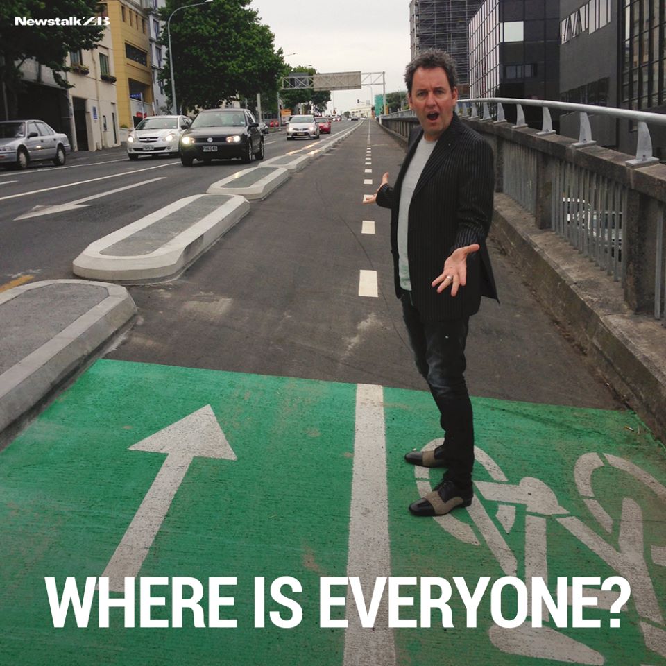
February is bike month and often the busiest month time of the year for people riding bikes. As such it’s a good time to look at the numbers to see how we’re progressing. Are the bike lanes empty, like Mike Hosking and some of his friends often like to claim or are they being used?
Auckland Transport now has 43 sites across Auckland where automatic counters have installed and that they publish the results of monthly – mostly in and around the city centre. They have published the data up to the end of January this year.
The counters are showing good growth and of the 31 for which we have at least 2 years of data, they are showing a 6% increase on a 12-month rolling basis. As you can see from the graph below, we’ve been seeing good growth, of generally over 5% for some years now. Note: AT calculate the increase differently, only looking at the results of 26 sites.
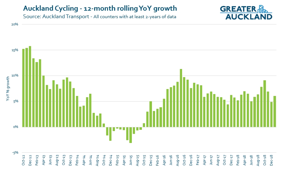
What’s notable about that is for some time now we’ve been seeing more rain in Auckland than normal, for example NIWA data suggests that over the last year we’ve had just under 1,400mm of rain. That’s around 24% more than normal. In saying that, rainfall seems to have more impact on the monthly numbers, for example using a similar method to above, we can see that numbers were down by 6.4% in December which is perhaps unsurprising given we had 224mm of rain, 260% of normal.
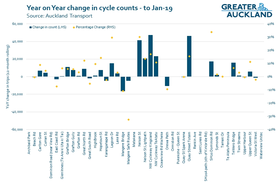
The graph below gives an idea of how each counter is performing. The empty ones are because we don’t have enough data yet for the comparison. As you can see, most routes have shown an increase with the biggest decrease being the Mangere Bridge. While some of the decrease may be because of the closure of the old bridge the diversion to the one attached to the motorway, numbers had been trending down at this location before that.
I’m not going to go into detail on every counter but here are a few of the ones from above.
Nelson St
This is of course the site of the famous picture of Mike Hosking above. Well anyone who’s been down that way recently will know it’s humming with bikes at peak times and it’s not not unusual to see cyclists queuing up at the lights. That is being reflected in the numbers with the counter registering 20k trips in January, up a whooping 54% on January last year.
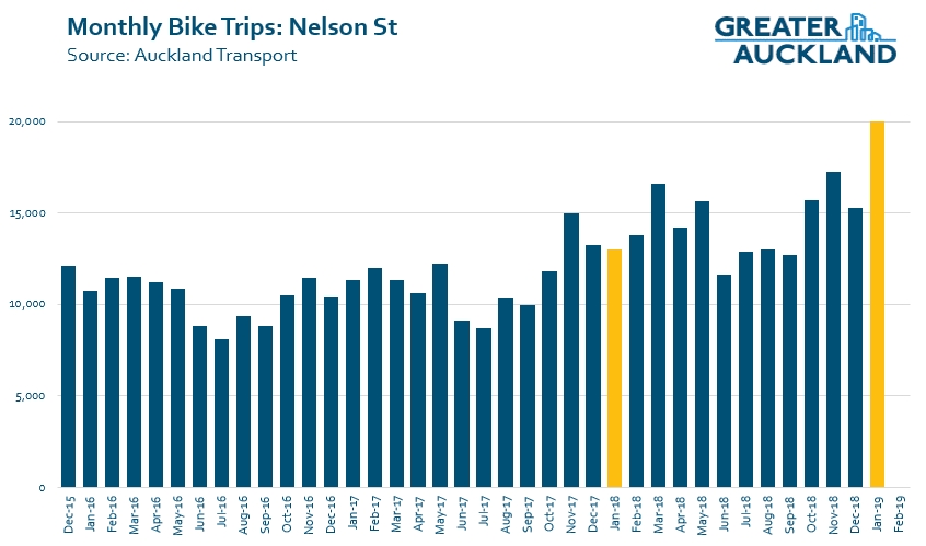
I wonder if this a flow on effect from the opening of the Ian McKinnon Dr cycleway in December? Speaking of which….
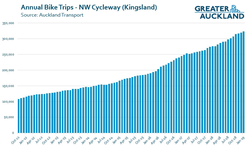
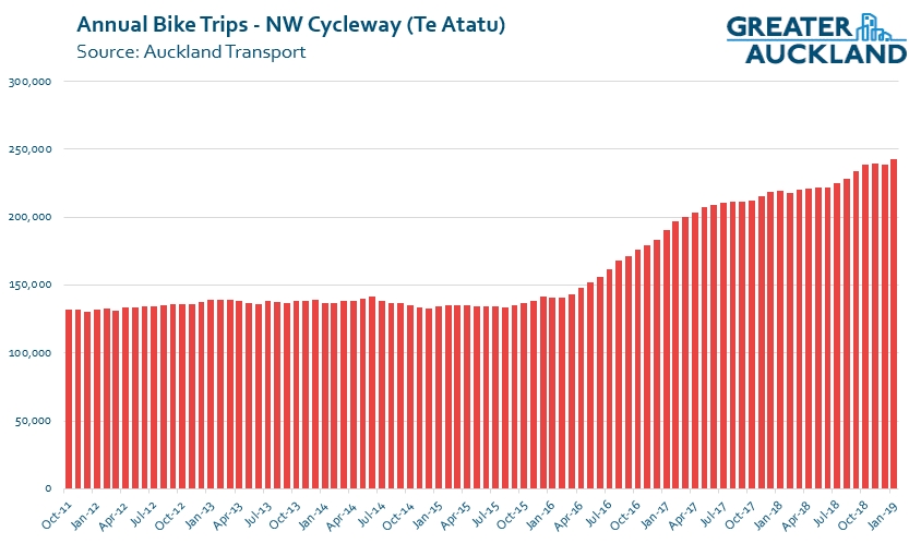
Northwestern Cycleway
The Northwestern has two counters, one at Kingsland and the other at Te Atatu. The Kingsland counter our ‘old faithful’ of bike growth and has been showing good growth almost every month since the counters started at the end of 2010. You can see this quite clearly in the 12 month rolling numbers with usage having risen from just over 108k trips annually to 323k. and there are only two months where the rolling year on year growth has been less than 10%
Further out, the cycleway numbers really took off after the motorway works finished.
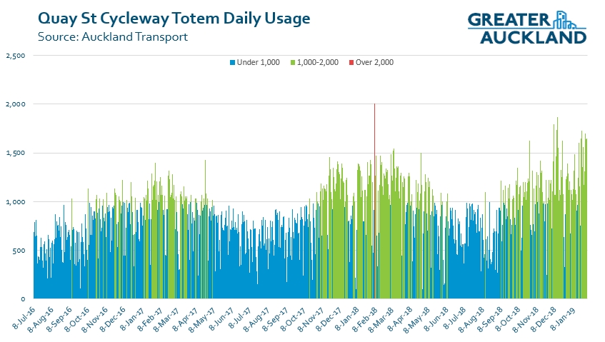
Quay St
Quay St has been a hive of activity with the downtown works underway and having narrowed the street – but retaining a separated cycleway for as much of the route as possible. A temporary counter has been in place after the original one was impacted by the works and AT say it and Nelson St have also been adjusted to detect scooters. Usage of the cycleway has been noticeably increasing for bikes and scooters and you can often see bunches of each riding along. This is reflected in the numbers where we’re seeing a lot more big days.
Finally, it’s also interesting to look at when people are riding. For this I’ve used the 26 counters that AT use as a cross-section of the city. Compared to the same period the year before, we can see that weekdays remain the busiest but that there has been some change and Wednesday’s have become the most popular day of the week for getting out on a bike.
Note: while public holidays are excluded, some of these results may be slightly skewed by them, e.g. the Christmas eve Monday sandwiched between a weekend and Christmas was significantly down on the other Mondays which is likely why it has been dragged down a bit.
 Overall we’re seeing some good numbers coming through from our cycleways as more and more people get out on a bike. This growth has also occurred at a time when Auckland Transport haven’t rolled out all that many new pieces of bike infrastructure. If they can get on with the delivery, we’ll see these numbers really jump up.

 Processing...
Does anyone know if Lime scooters and other escooters trigger the sensors?
Oops I reread the section about quay and nelson st st being adjusted to detect scoots. Presumably this means that the other detectors around the network do not detect scooters?
Hopefully they change them, because Lime already have lots, and some other companies are thinking about launching.
When I started riding to work again regularly about 5 years ago I’d typically see only 2 or 3 other cyclists on my whole trip. On Monday I decided to count the number of cyclists I saw coming the other way while I was going up the Grafton Gully pass, don’t know why, probably because there were so many waiting at the Alten Rd. lights, crowding out the traffic island. Anyway, in the 5 minutes or so it took me to get up the gully, 31 cyclists and 1 e-scooter came past me the other way.
And yesterday I spoke to 2 cyclists who were brand new to commuting and needed a little help wayfinding through the more confusing parts of the network, so there’s anecdata of new growth.
Now is really not the time for AT to be dithering with the already glacial roll-out of new bike infrastructure. The demand is obviously there so just get it done. And while much has been said of NZTA’s heel-dragging over light rail, I fear the same is happening with SkyPath. This is a really vital piece of the network, that will hopefully see some quality infrastructure being built on the shore, because apart from the compromised Northcote Safe Cycle Route, we’re lucky to even get a painted line over there.
The glacially slow progress has been bad enough, but plenty of communities are looking at the proposed programme and have realised that it’s not coming their way. Some of the gaps might be filled by the local boards, but if not, I’d predict some serious community-led tactical urbanism will spring up to satisfy demand for allowing children to cycle to school safely. Let’s hope Auckland Transport changes its culture quickly enough to be able to respond to this appropriately.
Weekday cycling certainly stronger than weekend cycling. It’d be interesting to see the difference for a period that doesn’t span the Christmas break.
The differences for days of the week just raise question marks for me. I mean, I can make up stories to account for Monday and Friday being lower, but not for why they’ve swapped in popularity. And why was Wednesday lower than Tuesday before but now is about the same? Or why are both of them stronger than Thursday? Any ideas?
I don’t cycle to work on fridays because of Friday drinks.
That’s the reason you do 😉
Soooo, you drive instead?
My initial assumption when reading this was Brook took PT instead of cycling. That’s been my default options for almost a decade now in 3 different cities.
The Quay street counter really tells half the story. I, for one, don’t use the cycle lane when coming into town from St Heliers. I would suggest that the amount of cyclists making the trip along Quay street is triple what the counter says.
Large groups of confident cyclists use the road when heading into town along quay Street. It may pay to have a counter just after the port to capture accurate stats.
Jason – I’m the opposite, i only cycle from Britomart to Victoria Park (last leg), so don’t use much of the cycle way at all but still add 2x counts a day
The one on Puhinui Rd is still deserted.
What is your definition of deserted? If it used to be car parking used by 20 people a day and now it is cycle lane used by 25 people a day, that is a net gain. But most of the time it would look deserted. (not saying this is the case, just an example).
Puhinui Road is an example of a badly designed, badly enforced and leads-nowhere cycle lane.
– It doesn’t protect riders from heavy traffic (paint is not magic) so only confident riders use it
– Confident riders (and everyone trying to use it) will constantly be forced to unsafely merge back into traffic because of cars parked in it
– There’s a massive gap in the middle, across the railway section, which is very intimidating if you are not already happy to ride in traffic
– there’s no bikeway to the airport in the west
– at the east end, there’s no safe link to the town centre, it just spits you onto a massive Great South Road intersection
Surprising it is badly used? It’s like a motorway for cars – if motorways had lots of main battle tanks driving all over the place, had a deep ford in the middle, and some kilometres before the end, suddenly turned into a gravel road.
Last para needs preserving for posterity. Best comment I’ve read in a long time.
It’d be really great if AT decided to upgrade the stretch of NW Cycleway (to a proper cycleway standard) between Takau St and Nixon Park as suggested by Bike Auckland. That stretch is really busy (and really bumpy).
It’d be great if it followed the grade of the motorway westbound and got rid of the hillocks, wiggles and on road sections all the way to the gt nth rd cycle bridge prior to the causeway including underpasses at Luke’s rd and carrington rd. it’d also be great if there was a bridge providing a more direct link with less elevation climb between the pink path at k’rd and cycleway westbound.
AT need to coordinate their bike lane infrastructure, better or maybe just have a plan.
Northcote Point had anywhere from $10 million to $18 million, depending on who you talk to, spent to create bike lanes…….to nowhere, for very very few users.
Upon its completion they almost simultaneously closed Northcote wharf, imperfect through its design was with no real plans to fix it or its crap design and have made NO progress it appears on Skypath.
This bike lane was a hard sell to very skeptical residents with plenty of money and pull and this waste only serves to prove the Hoskings of this world right.
It also stuffed up businesses, in the least, for no return. Surely the money wasted, I suggest on the back of emotive illogical lobbying, vis a vis Grey Lynn, would have been better spent connecting other well used lanes such as from West Auckland to the rest of Aucklands CBD.
The point you make about extending the current network versus creating islands everywhere is similar to the question of what should be built in each location. It all boils down to how much budget is there and what will provide the best benefit to the most people.
I think while we should be extending the network, we also need to create some islands of infrastructure, so that more communities get to benefit, reducing the possibility of the objection around the development of cycle infrastructure being limited to specific suburbs.
I’d like to think that every time there is a road renewal, an appropriate level of cycling infrastructure is installed, acknowledging that if there is no other infrastructure in the area, it is going to look empty for a while, as people adjust and start to use it.
I think the root problem is that we want to build some kind of best practice infrastructure, and nothing else. As a result, any investment we make will give us only a minimal amount of extra kilometres. So we have to pick winners and losers.
The road renewal is a missed opportunity. One way to arrange this is to paint cycle lanes right now, and upgrade it when maintenance comes along. Any of these new bits will immediately be part of a network. Painted lanes are not best practice but they’re much better than nothing (the status quo is usually swerving around parked cars).
See Damian’s comments about Puhinui Road above as to why the painted option is only a very small improvement for most locations.
No. Only his first point is a disadvantage of painted lanes.
There are other countries which consider Copenhagen lanes best practice. Copenhagen lanes have only a small kerb which is easy to mount for cars in case you’d like to, say, park on that lane. You need that enforcement.
You also need that connectivity. A common problem is lack of continuation over crossings. This is not specific to any type of cycle lane. You can’t usually continue those concrete blocks across intersections.
The most immediate problem in Auckland is that only a few percent of the population has access to bike ‘infrastructure’ at all. The Dutch also started out with painted lanes.
My assumption is that painting bike lanes is much cheaper and easier than building the more substantial options like off-road cycle paths or Copenhagen lanes. So you can roll them out much faster over much wider areas. That has 2 advantages. Even though not that much people will use them, a few percent over a wide area is better than 20% over a couple of ‘winners’. Second, the long play. Now you can combine upgrades with regular road maintenance, section by section.
Great that the cycling numbers are increasing so strongly. Really obvious how LITTLE rain affects numbers. December’s numbers down only 6.4% despite rain being 260% of normal is a good stat to quote: that’s a lot of riders who don’t get put off.
I’d like to see Auckland Transport do some research into:
– to what extent workplace provision of bike and gear storage, hanging spaces for wet gear, and showers affects rainy day downturn in cycling numbers
– to what extent the route that people use affects rainy day downturn in cycling numbers. Does, for example, a route that mostly uses an off-road cycleway have a different turnout on rainy days to routes that include a fair bit of on-street cycling?
In fairness a large chunk of December’s rain fell on the 24th and 25th, so these may not have been big cycling days anyway.
That photo is really telling. Yes there are no Cyclists. But there are only 6 cars (Back to the lights). Therefore they only need one lane right? I would like a nice urban park and it seems like there is plenty of room. Maybe GA should repeat the photo at peak traffic time showing stopped cars and freely moving bikes.
Anyone noticed that Hosking has got even more obsessed since the election. Almost every article I read is either a Labour beat up or National promotion. Its like there are no other subjects to talk about. I wonder how much the National party pay him?
You cannot hope to bribe or twist –
Thank God! – the Kiwi journalist.
But seeing what the man would do
Unbribed, there’d be no reason to.
Very good. Humbert Wolfe apparently, Kiwi’d. I was also wondering if payment would even be necessary…
You just know everything is in perfect synchronicity when the Hosk is telling us Cindy is taking us to hell in a hand cart. Well him and the old coot Soper.
The sky has not fallen in thus far Chicken Littles!
He actually wrote a couple of positive articles about the government late last year so I thought he might have reached the acceptance stage of grief, but it looks like he is still in the denial stage.
Jimbo – They don’t need to pay him, he’d be in the bracket that personally benefit the most from proposed National tax cuts
Its usually a 1-2 hit job on the Govt, in the Herald. A jab from The Hosk, followed up by one from the wife.
The big question for me is the opportunity cost of implementing cycling infrastructure versus other public transport (bus and train) infrastructure and congestion pricing technology. They might not be mutually exclusive physically but if there’s a limited budget, then they might be financially. I’d guess that more dedicated bus lanes and even no parking zones are a more cost effective way of getting people out of cars per passenger per km etc, not to mention implementing congestion and parking taxes/tolls.. i.e. cycle ways, like ferries are a nice to have but should they be a priority?
Mmmmh. At less than 5% of the budget (and much less actually being spent – they are always late and thus in practice massively underspend on their budgets) – why do you think they are a priority now? They aren’t. Not really. AT is several years behind the 3 year programme for Urban Cycleways. NZTA is late in delivering SkyPath and SeaPath. I could go on.
Also, I feel like you are a bit doing hunger games – “bikeways OR busways” – thinking here. Why not both? There’s a huge roads pot which is still not *really* being touched. Most of it still goes to enabling and maintaining single person car use. And bikeways support, not hinder, public transport – if we actually made it easy to ride to bus and train stations…
Exactly. And it might be worthwhile looking at some of the facts.
Europe found: “The automotive system is subsidised with a staggering €500 billion per year.” … “Due to positive health effects, cycling is an external benefit worth €24 billion per year and walking €66 billion per year.” – https://twitter.com/stefangossling/status/1088575145277513728?s=12
The UN guideline is: “Set aside at least 20% of the total transport budget to fund NMT
programmes at national and city level” NMT = cycling and walking. We’re more at 2%, I think.
Cycling investment repays itself $10 for every $1 spent (Victoria University research)
So it’s not cycling or buses that have to be traded off. It’s that roading budget needs to be reallocated to public transport, cycling and walking. And we will reap a good investment from doing so, in terms of lower public health costs.
It’s important to remember that the cycling network complements the bus network.
Damian, you’re not arguing the point I made, which is if there is a fixed budget (and unfortunately there is), where should it be prioritised? What gives most bang for buck? And I would agree it is probably not roading projects – my guess is buses and trains should be the priority over cycling and then roading and ferries in that order. But interested in actual analysis of this. And I also agree that riding to bus stations for example is a good symbiotic thing. But it is easy to be passionate about cycling because of all the feel good without backing it up with facts. Nice of Heidi to quote all the subjective health benefits (“facts”) of walking and cycling but realistically how many people can take advantage of those in Auckland versus taking public transport?
For most people the most frequent public transport lines nearby go every 15 minutes. And you have to walk to that bus stop. In the same time on a bicycle will already be a couple of km away.
For short trips (a few km) bicycles are unbeatable. And it just so happens that we have vast swathes of low density suburban developments where many people are a few km away from things like shops, rapid transit, anything.
You’re talking about how much bang for buck. I think you underestimate how cheap cycling infrastructure is compared to the rest. 600 million over 10 years? That is what, 1/5 of the cost of our planned light rail?
Is there some sort of robust study of dollars per km per passenger for each transport node in the Auckland context? Don’t get me wrong, I’d be on a bike to get to work if it was safe for me to do so (and that would require a dedicated cycle lane) but equally I am not sure if I’d be doing so on a wet winters day or when I’m 70, or if I have a heart condition, or if I lived in up in the Waitakeres and not an avid cyclist. But how much is that going to cost the ratepayer, what return is that on investment compared to other alternatives? These are all factoids being offered up here.
Dollars per km per person is not the right metric, because with good planning, trips will be shorter. Land use needs to be planned together with transport. We wouldn’t have sprawled so far if we hadn’t been subsidising driving so much, and a more compact form would assist other modes better. We have what we have, and buses definitely have to be a big part of the solution, but even with our huge area, we can provide good access for people if cycling and walking infrastructure is improved so people can get around their local neighbourhoods and also to the public transport. Some people will also cycle longer distances.
Heidi, yes you are right. So is there a robust study of dollars per journey/time per passenger or whatever metric for each transport node in the Auckland context?
Probably not if you’re going to consider public health outcomes ‘subjective’. I don’t imagine any analysis will be sufficient.
They’re very cheap to build, the only reason they look expensive is they are often done as part of a street renewal project, such as Beach Rd.
That’s why I think it should be part of the road renewal, not a cycling project.
As we reallocate corridor space away from SOV, it shouldn’t automatically be labelled something else.
Of course it should, with provision for safe cycling being a standard feature of all street renewals on every single street in the city. This must easily be the most efficient way to provide universally available cycling infrastructure.
Jezza, is the street renewal decision independent of the bike lane installation? If they are independent decisions, then the costs of the bike lane (estimated on a stand alone basis) need to be separated out to assist with the campaign for more bike lanes. If not, then that argument cannot be used.
There’s a good case for a bike lane along Bayswater Avenue on the North Shore. I now own an e-scooter and scootered down there to the ferry terminal a couple of times. I was passed by quite a few bicyclists, all on their way to catch the ferry. The avenue is plenty wide enough for a lane.
It seems to be part of the future programme: https://at.govt.nz/media/1152675/Proposed-Auckland-Cycle-Network.pdf although I’ve no idea when.
I found a 2013 suggestion from Bike Auckland for a different route: https://www.bikeauckland.org.nz/cycle-streets-a-cycle-boulevard-for-bayswater/
That’s my Bike AKL article Heidi! From a few years ago. When I was a wide eyed newcomer to Auckland and believed the Devonport-Takapouna Local Board cared about anything except cars and parking cars. Nothinhg ever happened with that boulevard idea of course.
Bayswater Ave had a painted cycle lane for a while in the ’00s I believe. But it was removed after local became apoplectic about a metre of “their” road being taken. I believe not even parking was removed.
It is a prime candidate for a separated bike lane (as many cyclists travel to the Bayswater ferry) and it is constantly discussed. But as the Local Board is against any cycling infrastructure, it will take a clearing out of the local board to get it done.
Thanks for the background, guys.
Does your “cared about anything” mean this instead?: cared about nothing
A problem of success is that heavy bike-lane usage means the question of safe usage becomes ever more acute.
I was moving at a normal speed onto the NW cycleway at Kingsland when another cyclist came barrelling down the hill right towards me. Thankfully everyone was able to apply the brakes and there was a controlled collision causing no injuries and no serious damage. But this raises the question of whether we should be giving speed warnings / Give Way signs on cycleways.
Perhaps some steep gradient at intersection signs too. I’m thinking of where you join the NW at Rosebank Rd to go east and have to check for fast cyclists from either direction while going down a steep grade, giving way and turning…
Of course the other big thing is – if they’re going to use FUMES paths (Following Unhealthy Motorways Easy Solution) then they need to design it in from the start – with plenty of separation for noise and air quality reasons, and use easier gradients to go under or over every on and off ramp. Really, to retrofit paths into the network, motorways aren’t the best place to start.
I’ve been commuting on the NW since 2005 and agree that it’s become a lot more demanding to ride safely. Apart from the Ian Mac section, even the “new” 2009-era part is starting to feel a bit narrow, and the original bits are now, I think, totally inadequate.
Pressure of numbers is the main issue. People don’t seem to have mentally adjusted to the likelihood (actually a near certainty in peak times) that someone else will be coming around the next corner in the other direction. Overtaking on corners with no visibility is completely routine. You *might* usually have gotten away with it ten years ago, but in 2019 the odds are truly against you (and the poor person coming the other way).
Ebikes are the other development and for sure there are some recklessly fast riders out there, but I think we would be seeing a big lift in ridership anyway with the other changes that have happened. Ebikes sadly add extra speed and weight to collisions but I think it’s inadequate path width that has become the issue.
I’d be in favour of give way signs where needed but perhaps also yellow no passing lines at identified blind corners – which internally should also be a sign to AT/NZTA that the path needs widening there (hey, we can dream).
https://www.nzta.govt.nz/resources/roadcode/cyclist-code/about-cycling/cyclist-responsibilities/
In the shared path section there is reference to ebikes to use lowest power setting.
However how many actual collisions are actually happening and how many involve e bikes ?
Mangers bridge is manually counted by security guards now, who are only there from 7am.
And who often stand together talking and maybe forget to count.
How do the security record their counting? What hours after 7 am? How can they be trusted? Is their counting visible to passersby?
I wonder if AT is doing any projections on e-scooter usage?
The cycling trend upwards is great. But the introduction of Lime, other players joining the market and the eventual rise in private ownership that those two things will drive, means these are going to be booming in numbers. And I assume the cycleways are the best place for them.
If I was considering a cycleway construction program properly, e-scooter usage uplift has to push the agenda more urgently. Surely/
Imagine the numbers for Te Atatu if there was proper infra to connect in, Peninsula luckily has something to the shops (apart from the nasty northbound crossing half-way where it switches to lanes – which has yet to have the signalized crossing fix implemented).
– Te Atatu South has a bike lane Southbound but a suuuuper bumpy shared path Citybound, esentially its a mess, then the bike lanes end in the middle of nowhere just past the Countdown or at School Rd if you are heading Edmonton way.
– The western side of Te Atatu South has the Henderson Creek shared path and this also ties in Henderson with a Shared path but this is super narrow for most of the way, its essentially a re-designated footpath, this ends in Henderson with a slightly wonky connection to the Opanuku Shared Path which is nice and wide and then there is the Oratia Stream Shared Path and West Coast Rd Shared Paths which are kind of isolated unless you are happy on the unfriendly roads in between…
– There is then a connection further down the NW to Central Park Dr shared path and the Triangle Rd cycle lanes, which offer some fairly decent connections, but Te Pai Pl is still yet to be designated properly, so the cycle lanes on Pomaria are kind of isolated from everything…
– The concourse has a Shared Path but kinda just ends across the bridge and is followed by some industrial roads which are not nice, and a coastal connection that could really use a bridge over to Te Atatu Peninsula
– Then there is a Shared Path from there opening in September to hook up various places on the way to Westgate
It really is just a mess, imagine if all this existing infra was linked together properly and had a few more legs forking out, the NW cycleway is essentially the cycle highway of the West until the Rail Corridor Cycleway is eventually implemented, yet is is not being used at full potential because of a lack of a networked approach and further infrastructure feeding in properly…
Its like having the NW motorway but without as many local roads attached to it… you might get the people living along the motorway and on the very few local roads attached, and those brave enough to take the muddy dirt roads (a crude comparison to cycling without infra) but thats about it…
We need foresight, action and haste from AT/AC/NZTA to get these numbers looking even better! But seems to be in short supply!
Don’t forget how the new extension from Lincoln Rd to Royal Rd requires 4 pedestrian phases to cross Lincoln Rd. At Royal Rd there is no through connection to Westgate. You will have climb up to Royal rd cross over then back down to the cyclepath beside the motorway. I have questioned NZTA many times at meetings about these poor designs but got no where.
This site gets more retarded every day. 5-6% represents good growth on millions of dollars of investment? Have I tripped across The Onion?
5% on 5% on 5% etc etc is good
I wouldn’t look at the traffic growth rather in response to billions of dollars of spending if I were you…
DrM – maybe you should go back to reading the herald and listening to 1zb…
This is pretty pleasing growth. Looking forward to even better once other routes are done or completed and more of a connected network is created.
Get out of the bike lane, Mike!
I think considering the general disjointedness of the bike network, such growth is impressive, and more than proves that the city deserves much more and better cycle infrastructure. I am in the process of setting up a bike group in Glen Eden (through Bike Auckland) and if anyone else has an interest in cycling in the New Lynn – Glen Eden – Sunnyvale area, I would appreciate your input. Comment on this message and we can join forces to connect Sunnyvale to New Lynn via bike!
My theory is that not all cyclists are arseholes, it’s just that there is a higher proportion of arseholes in the cycling population than in the general population.
https://www.radionz.co.nz/news/national/382903/auckland-s-northwestern-cycleway-too-dangerous-for-primary-school-children-principal
tried riding on cycle path once neally got run over not for me would tell my family young ones not to use them as to bloody dangerious , what planet are these people on that want you to =cycle with cars and boses . they should have a list every week of the peopie that are hurt or killed
And your solution is? Should it be to ban the cars and busses/bosses that encroached on YOUR space when riding a bike. Or should it be to ban bikes for daring to take away cars, and buses, and trucks assumed right to the entire roading corridor?